Monday, June 29, 2020

1927+1966 Cicero Avenue Bridge over the CS&SC in Chicago, IL

(Bridge Hunter; Historic BridgesSatellite)

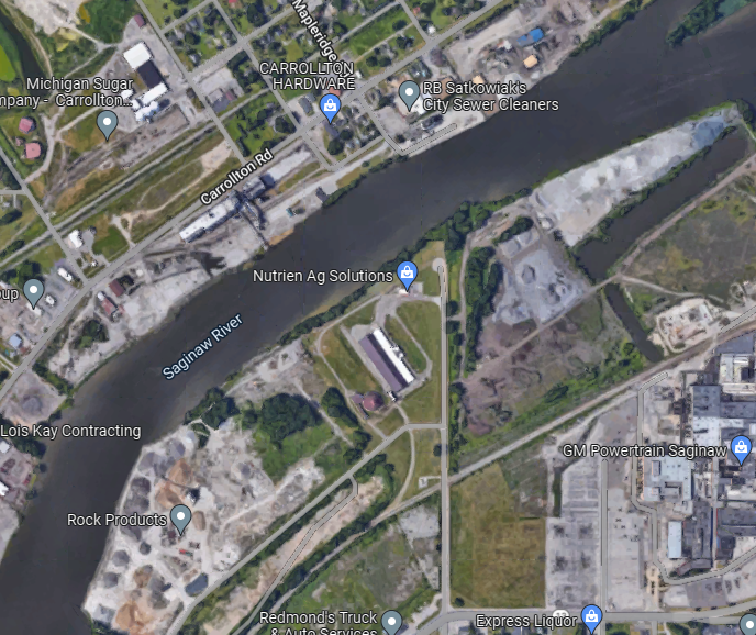
CS&SC = Chicago Sanitary & Ship Canal

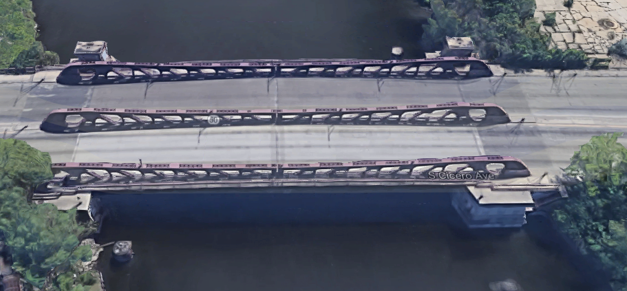
Historic Bridges indicates this bridge was designed by Strauss Engineering instead of the City of Chicago.

If you can find a place to park, it is easy to take photos of railroad bridges from road bridges. But the converse is not true. So I'll use a satellite image.
3D Satellite

MWRD posted
A soil boring crew works along the Chicago Sanitary and Ship Canal collecting samples for the foundation of the north abutment of the soon-to-be-built Cicero Avenue Bridge in Chicago, Illinois, on August 12, 1921.
[Are the piles still left over from the digging of the canal?]
Dennis DeBruler: This is also a nice view of the powerline that went from the Lockport Powerhouse to the switchyard building just west of Western Avenue.
MWRD posted on Jan 29, 2023

MWRD posted
The Cicero Avenue Bridge construction site on July 2, 1925, viewed looking north from the south side of the Chicago Sanitary and Ship Canal.
Dennis DeBruler According to Historic Bridges, the bridge was opened in 1927 with just two pony trusses. The third one was added in 1966 when the width was doubled. That is why the bridge looks so narrow in this photo.
https://historicbridges.org/bridges/browser/?bridgebrowser=illinois/cicero/
That expansion must mean that the trusses were overdesigned by at least a factor of two because the center truss now holds the weight of a whole leaf rather than just half a leaf.

MWRD posted
A view to the south showing flooring installation for the Cicero Avenue bridge over the Chicago Sanitary and Ship Canal on July 13, 1926. 
 
MWRD posted
A view to the southeast showing flooring installation for the Cicero Avenue bridge over the Chicago Sanitary and Ship Canal on July 13, 1926. 

MWRD posted on Feb 22, 2023
A view to the north from the Cicero Avenue bridge over the Chicago Sanitary and Ship Canal on October 11, 1926, during work on the north approach to the bridge. The Sanitary District of Chicago (now MWRD) built the bridge between 1924 and 1925 and the south and north approaches to the bridge were constructed between 1926 and 1927.

MWRD posted
A view to the east showing workers paving the northern approach to the under-construction Cicero Avenue bridge over the Chicago Sanitary and Ship Canal on November 5, 1926.

MWRD posted
A view to the north showing construction of the Cicero Avenue bridge over the Chicago Sanitary and Ship Canal in Chicago, Illinois, on September 7, 1926. The bridge was completed in 1927.

MWRD posted on Jun 4, 2022
Dredging for a cofferdam on the Chicago Sanitary and Ship Canal prior to construction of a bridge at Cicero Avenue on July 18, 1924.

Sunday, June 28, 2020

Steel is stronger in tension than compression

I've talked before about members in a truss bridge that are in tension are cheaper to build than members that are in compression. When I saw this photo I was reminded that steel is weaker in compression.
John Snyder posted
And when I saw this photo a week later, I decided that was close enough for my "2 in 2" rule to write about steel in compression.
William HBaird posted
Covered Hopper MOCX 426425 appears to be the victim of a very hard shove or a collision. Andy Cassidy took this shot in the CP yard in Coquitlam BC in June 2020. www.canadianrailwayobservations.com
Cameron Blanchard Looks like hump damage.
Tom Srb Looks like a Trinity Industry built car, they never did hold up even in normal usage situations.
Dave Drake Took more than a hard shove . Iol
John White Hit pretty hard to bend the sills like that.
Jerry Maddax I’m thinkin,a smidge over 4 mph

Rick Carpenter commented on William's post
And the demonstrations just kept on coming.
Screenshot
Walter A. Keil A fully loaded reefer like I assume that one is need to spread a bar across the top so it picks up straight up not towards the center.
Jim Snowy With the slings angled like that, there is compressive force created in the container. Normally they are lifted with a spreader so the force is purely lifting.
David Carnes commented on the above video
Containers are designed to be lifted from bottom 4 corners when loaded. Top will overstress and buckle them.
https://www.containertechnics.com/en/blog/safelyLifting
Brett Patrick David Carnes They're always top lifted at container terminals, but the jigs they lift with eliminate the included angle component which caused this failure.
Paul Marcati Directions on the side lol
Never pick loaded container from top pick points
Always use lower pick points
Any old truss bridge shows that members in tension are much cheaper (less metal and less fabrication) than members in compression. This is an example of v-lacing compression members.
Old Renwick Road
HAER explains that the truss members were fabricated in their shop and then shipped to the site and assembled using a local work crew under the supervision of a field agent who worked for the bridge company.

Morris Terminal RR Bridge over I&M Canal
This Big Four Bridge over the Ohio River is so big that even the "simple" members are rather substantial.
20151009 1090
Another bridge that has been converted to pedestrian use and allowed me to get up close and personal with the truss members was the 135th Street Bridge in Romeoville, IL.
20200313 1689

20170121 7700, Abandoned C&NW in Carpentersville, IL
This bridge is basically a Warren Truss. They evidently don't have pure tension members. But the vertical members are thinner than the diagonal members.
HV/C&O over Hocking River

The swing span is a Warren Truss, but the approach spans are Pratt trusses and the diagonals have just tension so they are simple bars.
Wabash Cannon Ball over Wabash River


Saturday, June 27, 2020

Three Swing Bridges over Saginaw River in Bay City, MI

Going downstream:
1890-1976 Lost/Third Street: (Bridge HunterSatellite)
1905 CM/MC + CN/GTW: (Bridge HunterHistoric BridgesSatellite) CM = Central Michigan
1892 LSRC/Detroit & Mackinac: (Bridge Hunter; Historic Bridges; Satellite) LSRC= Lake State Railway

You can tell that shipping is active on the Saginaw River because the railroad bridges are normally open.

Lost Third Street Bridge

JA Garfield posted two images with the comment: "Third Street Bridge 1889-1976, Bay City, Michigan. It opened in the middle of the night for a ship, and collapsed. Drawing by Scott Shaver."
1

2
JA Garfield posted seven photos with the comment:
More pictures of the Third Street Bridge, over the Saginaw River, that connected the east and west side of Bay City, Michigan. It was built in 1872, and collapsed June 18, 1976 as it opened for a ship at 3:10am. It had been struck by another ship passing trough the day before, which probably did structural damage.
Dan Mathers What is happening to the bridge today?
JA Garfield Dan Mathers Unfortunately they pulled it down, and built a typical DOT type drawbridge downstream to replace this, and another two lane swing bridge in town. Both new bridges have been nothing but trouble, and are down for repairs, more than they are open to traffic.
[I could not find a two lane swing bridge.]
JA Garfield When I was a kid, when we would hear a ship blowing for the bridge downstream, we would ride our bikes to this bridge, and ride the span when it swung open. We'd get a great close up view of the ships as they passed through a couple feet away.
[Bridge Hunter has newspaper clipping concerning the collapse.]
1

2

3

4

5

6

7
JA Garfield posted three photos.
1, cropped

2

3

Central Michigan/Michigan Central and Canadian National/Grand Trunk Western

Also known as the Bay City Bridge.

Street View

C Hanchey Flickr, Jun 2012, License: Creative Commons Attribution-NonCommercial (CC BY-NC) via Bridge Hunter
Central Michigan Railway Saginaw River Bridge (Bay City, Michigan)
Through truss swing bridge on the Central Michigan Railway over the Saginaw River in Bay City, Michigan.

Fred Sibert, Aug 2019
[This is obviously the MC Swing Bridge. It was mislabeled the Liberty Bridge. The Liberty Bridge is on the right in this photo.]

Marty Benard shared
Central Michigan RR Excursion with U23B 8904 built as Missouri Pacific 669 in Jan. 1973 crossing the Saginaw River in Michigan in 1992, Karl Miller photos.

Dennis DeBruler commented on Marty's share
Judging from photos and satellite images, this bridge is normally open.
https://bridgehunter.com/mi/bay/bh52118/
I found a Jun 2016 Google Earth that shows the bridge operating. It is almost in the closed position.


Lake State Railway/Detroit & Mackinaw


Street View

JA Garfield commented on a post
It was abandoned for many years and has recently been rehabilitated for use by the Lake State Railway, which runs on some of the old Michigan Central, and New York Central tracks in mid Michigan. A picture from September [2018]:

2 of 5 photos posted by Ben VanOchten with the comment: "The Dorothy Ann / Pathfinder was back in town over the weekend. She headed to Saginaw and then headed outbound towards Stoneport. Got some neat pictures of her going through the train bridge!"
a

b

I found several piles of aggregates on both sides of the river in Saginaw, MI. 
Satellite

Todd Shorkey posted
John J. Boland inbound on the Saginaw River at the Lake State Railway Bridge, headed to the GM dock in Saginaw to unload coal. Olive L. Moore/Menominee is in the background, tied up at the Port Fisher Terminals Dock in Bay City. October 1, 2022
[The GM plant is a "metal casting operation." (How many aluminum castings does an eletric car need?) Casting needs a lot of sand. That plant used to have its own slip. But now it must share the "GM Stone Dock" [boatnerd] that is across the river. A satellite image shows that all of the piles are shades of grey. But coal is black. In this day and age of closing power plants, who would be trucking coal from this dock?]

Friday, June 26, 2020

1905 BNSF/NP Bridge over Missouri River at Bismark, ND

(Bridge Hunter; no Historic Bridges; John Weeks III3D Satellite)

"Built 1905, reusing the piers from an 1882 bridge." [Bridge Hunter]

BNSF is going to build a new bridge. It wants to replace this one. Some citizens want the new bridge to be on a new alignment so that this bridge can become a trail.

Street View, Aug 2019
[This is another reminder that the nation got a lot of rain in 2019.
This post taught me to try to get a street view from I-94.]

I was surprised the Missouri is so wide this far north.
John Weeks III

USGS-keelboat, (Credit: Brent R. Hanson, USGS. Public domain.)
The Missouri River flooding Keelboat Park and Keelboat Boat Ramp in Bismarck, ND. In the background is the Burlington Northern SantaFe Railway Bridge.

USGS-tie-gang, (Credit: Brent R. Hanson, USGS. Public domain.)
A tie gang traveling to the site to change ties or traveling away to pack up for the night. Tie gangs are part of the maintenance crew.
[Note that during this June 9, 2011, flooding the ice breakers on the piers are almost covered.]

USGS-ice-cover

Brian Ambrose updated
Rich Wallace There is a theory that when you leave a location, the train will come. Seems to have been my experience when I have seen others shots who were also at that location. Now I try to get them to leave. Ha!
Dennis DeBruler I was at Union Depot in Joliet to meet my uncle and his railfan friends. BNSF was dead. I kidded them that I'd go check out Brandon Lock so that the trains would start coming. Sure enough, they did come after I left.


Brian Ambrose posted
Well I got my shot at the Missouri River bridge this morning. But the clear blue skies were gone replaced by bright overcast. Instead of going straight to the bridge I went down into Mandan to see if anything was there ready to go east. I should have done that yesterday! But while driving there I heard the dispatcher on my scanner talking to a westbound already west of Mandan saying they'd be meeting two eastbounds at Lyons. Ah, there were two coming at least. But checking Mandan I found there was already an eastbound autorack train here and figuring it would have to leave before the other two eastbounds arrived I had better get up to the bridge now. Arrived at the bluff and back to my spot from yesterday, set up the camcorder, and horns blowing from the west. It was almost here! Single SD70ACe up front of the long autorack and no DPU on the rear. Not sunny but at least I got something. It was 80 and rather humid too.
Paul Birkholz Perhaps empties going to storage with just one unit?
Richard Olson Nice, and the autoracks help keep your eye following the train beyond the bridge.
Brian Ambrose Good point. Coal hoppers or grain cars would not have had the same effect.

This was a popular railfan location.
Jim Kleeman posted
A new crew has just hopped on board the head end of a loaded Powder River coal train in Mandan, ND. They new lead their three EMD SD60s (9020/9026/9055) across a not-so-wide Missouri River onto the BNSF Jamestown Subdivision. Next stop Dilworth, MN. We're overlooking the action at 8:50 AM on 9/24/2004 in Bismark, ND.

These 1882 piers are made with granite. The spans were built in 1905. [John Weeks III]
Brian Ambrose updated
Brian Ambrose And this is the second train of the morning approaching the bridge from down below along a walking trail. Now it is raining, and 78 humid degrees.
Jim Weisenbach Icky weather... sounds like 'home' (NJ)
Dennis DeBruler A nice view of the ice breaker on the pier.
Maybe BNSF would be better off moving the new bridge to a new alignment.
Based on a paper written by Ed Murphy of the ND Geological Survey, the railroad (first Northern Pacific, and now BNSF), have had endless problems with the eastern pier of the High Bridge. Just after completion, the east pier began shifting towards the Missouri River at a rate of 3 to 3-1/2 inches per year. A number of repairs were attempted, but none seemed to work. In 1898, the pier was dug out and moved back onto a larger foundation. By 1902, the pier was already 4 inches off center. After further investigation, it was suspected that the city water reservoir located on a hill above the railroad track was leaking large amounts of water, causing the entire hillside to slide towards the river. The NP built a tunnel under the area to try to drain the water, but the pier continued to move. More projects were completed in 1918, 1923, and 1940 to try to slow down the landslide. In 1951, the NP undertook a major project to cut down the hill and regrade the area. This helped the situation by slowing down the movement to 1/3 of an inch per year, but did not stop the movement. [John Weeks III]
According to John Weeks, BNSF runs most of their trains over the former GN route. This NP route became busy hauling Powder River Basin Coal. But that traffic is drying up as coal-fired power plants are being converted to gas or shuttered. So the cost of stopping traffic on this route while they replace the bridge might not be high enough to help save the old bridge with a new alignment.

Michael D Thoreson posted three photos with the comment: "A loaded coal train crosses the Missouri river bridge between Mandan and Bismarck, ND on Sunday morning, 9/19[/2021]."
1

2

3

(new window)


3 photos with a standard cab BN livery locomotive

safe_image for Rail bridge dispute continues
"The bridge was completed in 1883 making it almost 140 years old."
Dennis DeBruler: 1883 would be the date for the predecessor bridge:
This bridge has a date of 1905:
However, the piers are from the older bridge.

safe_image for Preservation group working to save historic railroad bridge over Missouri River
The 1883 railroad bridge was “crossed in the early years by notables including former presidents Ulysses S. Grant and Theodore Roosevelt, as well as Sitting Bull.”

inforum
A rendering of proposed changes to the 1883 [actually, 1905] Bismarck-Mandan Rail Bridge, including a walking and biking path. The group Friends of the Rail Bridge maintains the historic bridge and a new BNSF bridge can coexist.
Contributed / Friends of the Rail Bridge