Showing posts with label rrMonon. Show all posts

Saturday, May 17, 2025

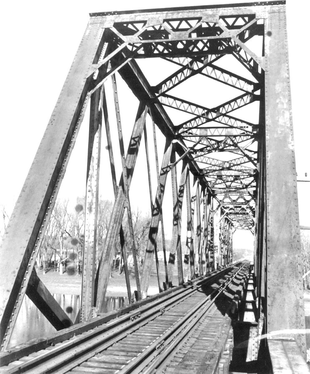
1895&1890 Lost/Monon and 1890,2011 Tioga Road Bridges at Monticello, IN

Monon: (Archived Bridge Hunter; Bridge Hunter; no Historic Bridges; Satellite)

Darin Patrick posted four photos with the comment:
Dear Friends. Happy St. Patrick’s Day! Today often reminds me of my youth and high school track practice.  
And our annual St. Patrick’s Day plunge off the Monon Bridge! 

During my illustrious high school track career of the mid 80’s, on St. Patrick’s Day the track team would run down to the Monon rail line bridge that crossed the Tippecanoe river just north of Highway 421 coming into Monticello (see photo 4). 
The Sportsman Inn can been seen in the far left of the Photo.
The Plunge participants would leave the track, run 1.5 miles down to the bridge, leap off the top, then run back to the high school. Oddly enough this annual practice was coach approved. As Solomon said, with every time there is a season, and with every season there comes changes in coaching practices…lol
But as we used to say on the run back to the high school…. May misfortune follow you all the days of your life, but never catch up!
Happy St. Patrick’s Day! 
I took these photos some years later, before they demolished the bridge. Enjoy the view.
Darin Patrick shared with the comment: "Happy St. Patrick’s Day. Monon rail fans."
1

2

3

The US-421 Bridge had a lot more character back then.
4

Note the road bridge behind it. And this image clearly shows that the truss was pin connected.
BridgeHunter

1910 Postcard via BridgeHunter
.

Tioga Road Bridge


2013 Photo by Tony Dillon via BridgeHunter, cropped

Note the railroad bridge behind it.
1910c Postcard via Bridge Hunter

HistoricBridges
When this was restored in 2011 as a footbridge, it recreated the original ornamentation and railings. I added the label "bridgeRare" because Nathan says Whipple truss bridges are rare, especially multi-span bridges.

Paul Fischer, Dec 2012

Street View, Oct 2023

Bonus


Neil Riley commented on Darin's share
Would this be the same bridge? Pictures from when my father was a remc lineman that went to white county to assist after tornadoes in the early seventies.
Dennis DeBruler: Neil Riley Judging from the piers and girders, this looks like the TP&W/Pennsy bridge, https://maps.app.goo.gl/oaLyaqpvkZ9MFCRH9.


Friday, September 15, 2023

Monon Trail Freedom Bridge over IN-25 near Delphi, IN

(Bridge Hunter broke Mar 22, 2023; Satellite)

I got my masters degree at Purdue in Lafayette, IN, and my hometown is Fort Wayne, IN, so I drove IN-25 several times between those two towns. Parts of that road followed the Wabash river so closely that it was a twisty, 2-lane road for many miles. And you could not pass a slow vehicle because of all of the curves in the road. It is nice to see that Indiana finally replaced that road. And it is nice that they did not allow the new road to sever the trail on the Monon Railroad RoW to the High Bridge over Deer Creek. And it is even nicer that they preserved a pin-connected truss to build the trail bridge. Taking a quick look at a map, it appears that US-24 between IN-25 and Fort Wayne has also been upgraded to a 4-lane highway. Now if Indiana could just get a third lane added to I-65 all the way between Gary and Indianapolis, I would be a happier camper. Google Earth shows that the new IN-25 by Delphi was built between Dec 2013 and Sep 2014. And it looks like that might have been the last segment of the new highway.

Street View, Aug 2018

It is obviously a pin-connected truss.
Street View, Aug 2018

2 of 5 photos posted by Kevin Culver. 
Kevin Culver shared
a

b

Because of the economic legacy of the Wabash & Erie Canal, there was a lot of truck traffic on this country road. That made it even more significant that Indiana finally made it easy to pass slow traffic. Judging by the photos on Google Maps, Indiana took advantage of the federal funding for a new highway and built a fancy interpretive center as well as preserved a truss bridge.
Amanda Gorringe, Jul 2019, cropped

Tuesday, February 9, 2021

Dyer Junction: Monon vs. EJ&E & Michigan Central and Monon Depot

(no CRJ; John Haynes Track DiagramSatellite)
NorthAmericanInterlockings: none
Chicago and Northern Indiana Railroad Interlocking Towers (click the marker for the correct information)

American-Rails.com posted
Monon C420 #507 leads a southbound manifest across the Penn Central (ex-New York Central) and Elgin, Joliet & Eastern at Dyer, Indiana on March 27, 1971. David Hawkins collection.
Jeff Ewoldt: Note the International Harvester combine, manufactured in East Moline, Illinois.
[Some comments discuss the high signals by the depot concerning train orders. Others discuss the car with the man sticking out of it.]

Bill Molony shared

Jeff Michaels commented on America-Rails.com's post
My father and me were there about 7 years later.

The brown roof blends in with the brown field. I would not have been able to spot it without knowing it was in the northwest quadrant of the Monon vs. MC crossing.
1938 Aerial Photo from ILHAP

The red rectangle identifies the depot and the yellow rectangle is for the junction tower.
1938 Aerial Photo from ILHAP plus Paint

The town started south of the tracks so it is interesting that they built the depot north of the tracks.
1938 Aerial Photo from ILHAP

Jon Darmon posted
Dyer Drone Picture looking east.
They been working on both bridges all summer.
Skip Burch: Hart Ditch flowing under the J and the Monon.


A Roger Puta Photo
Marty Bernard's comment:
MONON F3A 208 with Train 5, The Thoroughbred, rounding a curve after crossing the NYC and EJ&E at Dyer, Indiana on February 10, 1963.
Since Marty indicated that a different picture with Train 6 was northbound, this train would be southbound.

I believe the building on the right is the depot.

Sunday, August 9, 2020

Davis Ferry and CSX/L&N/Monon Bridges over Wabash River

1912 Davis Ferry: (Bridge Hunter; Historic Bridges3D Satellite, now part of the Wabash Heritage Trail)
Monon: (Bridge Hunter; Historic Bridges3D Satellite)

Davis Ferry

Street View

Bob Kalal photo via Bridge Hunter comment

Monon


Photo via search result via SHAARD search
The Pennsylvania Steel Company of Steelton, Pennsylvania, built at least the plate girders of this six-span structure. The two all-riveted Warren through spans at center are flanked by a pair of plate girder approaches at each end, the whole of which rests upon cut-stone abutments and piers to the east and a concrete substructure to the west. Each Warren truss uses I beam verticals to demark its six panels. Collision struts of two pairs of laced angles brace the endposts. The diagonals are fabricated from a pair of channels and battens, the channels used being much heavier toward midspan. Attached at the lower chord, heavy girder floor beams carry two sets of timber ties to which the rails of the two tracks are spiked. [StructuralTab]

Street View

Photo via StructuralTab

Statement of Significance:

The masonry foundation for the substructure suggests a 19th century crossing. The present trusses are the only double intersection Warren throughs known to exist on Indiana's rail system. The spans are heavy, unadorned, and appear to retain their original members, except for the 1924 replacement of the most northerly through span. [Historic Bridges comments: "This railroad truss bridge is noted for its uncommon double-Warren truss configuration."]

Architectural Description:

Seated upon a concrete-over-stone substructure, this six-span bridge consists of two deck plate girder spans at each approach and two double-intersection Warrens across the main waterway. The structure carries a single track upon the usual timber tie deck.

Each through span is riveted and subdivided into eight panels. Crafted I beams provide the only vertical--from the top chord-endpost connection to the initial floor beam. Diagonals of crafted I beams cross the two most central panels, (and are riveted to plates at the intersecting points), extends outward from the 2nd, 3rd, 6th, and 7th top panel points, and provide an extra diagonal from the lower region of the endpost to the first floor beam. Pairs of angles riveted together stretch inward from the 1st, 2nd, 7th, and 8th top panel points to complete the pattern of diagonals. Both floor beams and stringers are made of girders riveted to the trusses above the lower chord.

A wreck in April 1924 caused the northernmost through span to collapse, and thus three double-intersection Warrens were reduced to the present two and a pair of shorter plate girders replaced the demolished span.
monon,org
The Wabash River bridge, spring 2003. After record rainfalls the river is coming close to the tracks. -Courtesy Gene Cassman-
[This monon.org page has a couple more photos taken with a high river level. One of them shows a dog on the track. It also has three photos of the train 1924 train wreck on the bridge.]


Sunday, January 12, 2020

Lost/CSX/L&N/Monon over Wabash River at Delphi, IN

1949 Steel Girder Bridge: (Bridge Hunter; no Historic Bridges; Satellite, even the piers were removed)
1897 Truss Bridge: (Bridge Hunter)
ca. 1852 Wood then metal, Crawfordsville & Wabash Railroad: (Bridge Hunter)

1949


Indiana Historical Bureau posted
On January 11, 1956, the Chicago, Indianapolis and Louisville Railroad officially adopted the "Monon" Railroad name. According to Traces of Indiana and Midwestern History, the line became one of the US's first entirely dieselized railroads and was one of the most used railroads in Indiana during the Civil War due to its alignment with the directional pattern of the war.
Learn more about the Monon Railroad with this issue of Traces: http://bit.ly/39rhvSM
The image below is courtesy of Wikimedia Commons.

Jeffrey Kennan The image was created by famed artist Howard Fogg.
Howard was also a WW2 fighter pilot
" he flew 76 combat missions in P-47 Thunderbolts and P-51 Mustangs and was awarded the Air Medal with three clusters and the Distinguished Flying Cross with one cluster."
Https://en.m.wikipedia.org/wiki/Howard_L._Fogg

Bob Pooringa shared
[Bridge Hunter also has this image.]

I didn't notice that they added concrete piers between the stone piers until I saw this photo. I assume the concrete piers were added in 1949 when the replaced the truss spans with steel girders.
Photo taken in 1949 (courtesy of Mahlon Eberhard) via Bridge Hunter

Photo taken ca. 1990 (courtesy of Carroll County Historical Museum) via Bridge Hunter

Abandoned RR Map

1897


Postcard courtesy of Carroll County Historical Museum via Bridge HunterCirca 1920

Photo taken ca. 1949 (courtesy of Mahlon Eberhard) via Bridge Hunter
Note new piers under construction. Soon these trusses would be replaced with a new bridge.
[Confirmation of my theory that the concrete piers were added when they replaced truss spans with girder spans.]


1852


Photo courtesy of Carroll County Historical Museum via Bridge Hunter
It appears that most of the wooden Lattice spans have been replaced with steel Pratt truss spans.

Photo courtesy of Carroll County Historical Museum via Bridge Hunter1890 Train wreck in which the approach collapsed.


Saturday, December 21, 2019

Sazerac's Northwest Ordinance Distilling in New Albany, IN

3D Satellite

This distillery occupies a former Pillsbury plant. General Mills has abandoned quit a few large plants in the Midwest. The plant was 55 years old when closed and had 400 employees. "The job loss does not end at Pillsbury. The adjoining Sonoco plant, which made packaging for the Pillsbury products, is closing as well, taking all 76 jobs with it." Demand for the products of this plant was down because Americans are eating less carbs and trans fats. [WDRB]

The distillery is of particular interest because it is causing CSX to rebuild their Monon tracks in New Albany, IN. I'm surprised the satellite image shows railcars at the building because the CSX tracks have been unused for five years. Google Map images are normally more recent than five years. "The rails run from the Kentucky & Indiana Bridge through portions of uptown, running along East 15th Street and eventually making their way down Grant Line Road....In total, the line will affect 21 street crossings and nine alleys." [IndianaEconomicDigest]

Saturday, May 11, 2019

Aban/CSX/L&N/Monon Bridge over Tippecanoe River at Monticello, IN

(Bridge Hunter; no Historic Bridges; see below for satellite)

Built ca. 1895, demolished ca. 1986. [Bridge Hunter]

Ted Gregory posted
What an interesting design on this structure. Looks like it's upside down from your typical through truss bridge. An Indianapolis bound Monon freight crosses the Tippecanoe River near Monticello, IN.
Photo from Monon Railroad Historical Technical-Society.
By Mike Schafer
1971

Two photos from the Indiana State Department of Natural Resource, Division of Historic Preservation and Archaeology via Bridge Hunter. The water level on the piers looks like these photos were taken after the Oakdale Dam was built.
1

2

Satellite plus Paint
The piers before the dam was built.
Photo from monon.org Monticello page's 


Screenshot
James Torgeson This footage looks like it could be part of a John Mellencamp video!
USGS Topo, 1953 Danville scale 250,000

The right-of-way was still intact in 1999, but the bridge was gone.
Google Earth, 3/26/1999


Tuesday, October 9, 2018

Burnt/CSX/L&N/Monon Bridge over East Fork White River near Bedford, IN

Satellite
(no Bridge Hunter? I saved the satellite image to catch the log jam)
Carlton Crasher posted several photos with the comment:
Someone else posted back in February about this trestle thought I would bring some perspective from the other side of this bridge in Bedford, IN. On this side you have to cross a gate and walk 1/2 a mile or so. This is the one that burned in 2010.
1

2

3

4

5

6

7

8

9

10

11

12

13
Richard Koenig commented on Carlton's posting
Here's a shot of the same bridge, from the 1970s...

Power Far From Home

Canadian National GP38-2 number 5518 is on the point of a southbound L&N train on the former Monon between Louisville and Chicago. The location is the East Fork White River, just south of Bedford, Indiana.

Image by Richard Koenig, taken on 15 May 1977; from the collection of John Rust.


Some comments from Carlton's posting:

Dan Meno Great post Carlton! I especially appreciated the video. Can I assume this was an arson fire back in 2010? (if u know) I'm from INDY with family who grew up in Bedford. This trestle is crossing the White River I'm guessing?? Thanks!!

Carlton Crasher Dan Meno it was under suspicion at the same time the tulip trestle in green county caught fire multiple times that year. I'm actually not from the area and i don't know if they ever had a ruling on it. Just a bridge lover and had to stop!

Dan Meno Carlton Crasher Thx for your reply. I didn't even know abt the TulipT fires.

Carlton Crasher Dan Meno yeah same year from what I've read in 2010. CSX was offering a reward for information at the time. From what I've read this line was inactive other than some non CSX trains using it between Bedford and Louisville. CSX supposedly hadn't used it themselves since '93. Definitely nothing going across since 2010 though.

John Wilson I worked on the Old B&O line from Cincinnati to St Louis. From the late 1990s to 2007 we had trains out of Louisville that came through Mitchell, and used Washington, IN as a crew exchange terminal. In 2007, CSX rerouted the trains through Evansville/Vincennes/St Louis. Now, no trains run that way and the line Flora, IL to St Louis is shut down 93 miles.