Showing posts with label wwMiss. Show all posts

Sunday, July 13, 2025

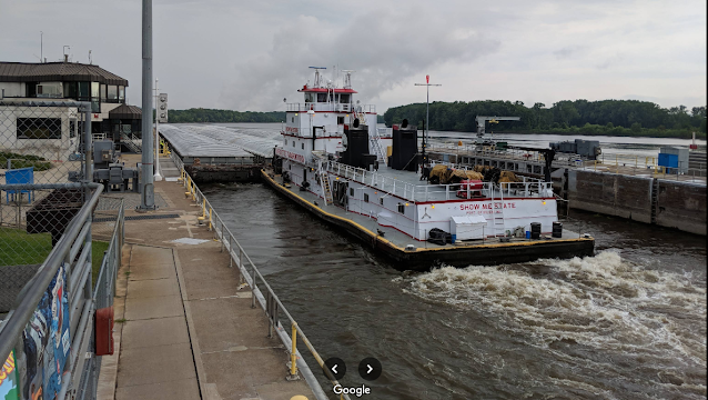
1938,1991 Mississippi Lock and Dam #3 near Red Wing, MN

(Satellite)

USACE
"Constructed and placed in operation July 1938. The site underwent major rehabilitation from 1988 through 1991. The dam is 365' [111m] long with four roller gates. More than 2,000 feet [610m] of earth embankment with a series of upstream spot dikes completes the structure to create Pool 3."

USACE, St. Paul District posted
In celebration of our 250th anniversary we #TBT to July 21, 1938, when construction was completed on Lock and Dam 3 in Welch, Minnesota.  
The dam is 365 feet long and includes four submersible roller gates. With 2009 federal and American Recovery and Reinvestment Act contributions, an 862-foot-long guide wall extension was completed in April 2011 and a closure dike to mitigate outdraft conditions near the guide wall was completed in October 2011.

RepublicanEagle, File photo

A view with the roller gates all of the way up.
2:14 video @ 0:41

Steve Nieckarz, Aug 2018

Steve Nieckarz, Aug 2018

USACE_report
I'm writing this on Jul 13, 2025, and the gates are all the way up for dams 3, 5a, 9 and 10.

The lock closes when the flow exceeds 125kcfs. [RepublicanEagle]

Tuesday, December 10, 2024

1881+1913,1963 UP/C&NW/Chicago, St. Paul, Minneapolis and Omaha Bridge over St. Croix River at Hudson, WI

1913: (Archived Bridge Hunter; Historic BridgesSatellite)

Mark Boettcher, Sep 2020

Mark Boettcher via HistoricBridges
In the late 1800s, much of the original bridge was filled in so that what is left is 568' (173m) long with a main span of 314' (96m).

"This bridge is strengthened and electrified in 1963." [BridgeHunter_1913]


Monday, November 25, 2024

1884,1890-1965+1965,2012 Washington Avenue Bridges over Mississippi River in Minneapolis, MN

1965,2012: (Archived Bridge Hunter; John A. Weeks IIISatellite)

"The first bridge at this location was built in 1884. The 1884 structure was reconstructed in 1890 to accommodate streetcars. Streetcar service ended in 1952, and the bridge was determined to be obsolete shortly after that time and was dismantled in 1965." [JohnWeeks]
The bridge was strengthened so that light rail could be added in 2012.
 
Robert Swann commented on a post
Washington Avenue Bridge, about 1885.

Photo via umn
1940

JohnWeeks
This photo "is from a historic display located on the University of Minnesota campus. It shows the original Washington Avenue Bridge circa 1905. This iron truss bridge was in place from 1884 to 1965."
[Note the number of people that used to live on the Bohemian Flats flood plain.]


Photo via umn
Campus Views. View from SW showing Washington Ave Bridge under construction, 1965
.

1965 Bridge


Street View, Sep 2013

The upper deck is dedicated to pedestrian traffic because the University of Minnesota built an expansion of the campus on the west bank of the Mississippi River. Because the winters get cold in Minnesota, the students have the option of an enclosed walkway. Unfortunately, according to the Google search results, this is a popular suicide bridge.
Street View, Sep 2014

Street View, Oct 2023

The traffic capacity was reduced by half to add the light rail.
Street View, Oct 2008

"So, when is a bridge a girder--and a steel stringer--and a deck truss--all in one? This bridge started out in 1965 as a plain deck girder bridge and remained as such until 2010, when a massive project began to upgrade the bridge to carry light-rail traffic. The plan was to add stringers to increase the load-carrying capability, but the original stucture's rigid cross-members didn't allow it. The design engineers came up with a very creative and innovative way to address this--instead of solid stringers, trusses were designed and installed, one member at a time, to fit around the existing sway bracing without having to remove any of it! And so, as a result, the main spans still retain their full original girder system, with multiple 'stringer-trusses' to support the light rail vehicles." [BridgeHunter]

This view caught the construction after the trusses had been added to the east lanes, but before they were added to the west lanes. So we get a good before-and-after view of the stringers. And since the Warren trusses had not been painted, we can easily see the trusses.
Street View, Jun 2011

MNDOT
"Design and construction of a double-deck, welded, haunched, continuous plate-girder bridge using A441 high-strength steel."
"This bridge was one of the first in the nation to use A441 high-strength, low-alloy steel in its superstructure, which allowed for the structural connections to be welded rather than riveted."

History’s Mirror posted
The Washington Avenue Bridge under construction in 1965 marked a significant shift in Minneapolis infrastructure, designed to link the East and West Bank campuses of the University of Minnesota across the Mississippi River. As steel beams and concrete piers rose over the water, the bridge's distinctive double-deck structure began to take shape—upper deck for pedestrians and bicycles, lower deck for vehicles and transit. Cranes hovered over the river while workers in hard hats maneuvered rebar and poured concrete, braving Midwest weather to stay on schedule. Barges floated nearby carrying supplies, and scaffolding clung to the bridge’s skeletal form. From the riverbanks, curious onlookers watched as the city expanded its reach. More than a functional crossing, the bridge was an architectural response to the university’s growing student body and the city’s evolving transportation needs. When completed, it would become a defining feature of Minneapolis, offering views of the skyline and a vital connection between academic and civic life.


Wednesday, November 13, 2024

1995 Veterans Memorial Bridge over Mississippi River at Gramercy, LA

(Archived Bridge Hunter; no Historic Bridges; John A. Weeks IIISatellite)

The bridge is 3,009' (917m, 0.6 mile) long. [BridgeHunter]
It has a main span of 1,460' (445m) with a clearance of 165' (50m). The bridge cost $110m. [GribbleNation]

This must be one of the last cantilever bridges built in the US because cable-stayed bridges became standard practice for large bridges.

Boat View, Nov 2016

I was going to skip this view because the levee blocks the view of the bridge. But the levee itself is insight as to how dependent lower Louisiana is on the continued integrity of levees. And it is a decent view of the cantilever towers.
Street View, Mar 2023

United States beauty posted
The Gramercy Bridge, also known as the Veterans Memorial Bridge, spans the Mississippi River and connects Gramercy and Wallace, Louisiana. Opened in 1995, it provides a critical link between St. James Parish and St. John the Baptist Parish, enhancing regional connectivity and facilitating the movement of goods across southern Louisiana.
As a cantilever bridge, it features a distinctive structure with steel trusses, designed to withstand the river’s powerful currents and the area’s sometimes challenging weather. The bridge supports both vehicle and pedestrian traffic, offering a reliable alternative to the ferries that once served the area. The Gramercy Bridge is part of Louisiana Highway 3213 and is essential for connecting local communities to major routes like Interstate 10, which runs parallel to the river, and other nearby highways.
[It is the piers, not the trusses, that are designed to withstand the powerful currents. The trusses, and piers, do have to withstand winds.]
Named in honor of military veterans, the bridge is also a symbol of resilience for the region, and it’s been beneficial for economic activity, supporting the sugar, petrochemical, and other industries vital to Louisiana’s economy.
Henry McKee: That is a part of Cancer Alley on the Mississippi River between New Orleans and Baton Rouge.

GribbleNation, this webpage as many more photos of the bridge.
"In the aftermath of the George Prince ferry disaster that claimed the lives of 78 people in October 1976 in nearby Luling, LA, the state of Louisiana began the process of gradually phasing out most of its prominent cross-river ferry services, a process that remains a work in progress today. While the Luling-Destrehan Ferry service was eliminated in 1983 upon completion of the nearby Hale Boggs Memorial Bridge, the ferry service at Gramercy, LA in rural St. James Parish was seen as a safety issue and planning for a bridge in the area commenced shortly thereafter....The desire to eliminate the ferry crossing in Gramercy was an unnecessary overcorrection. Passenger ferries themselves are not dangerous modes of transportation when they are placed in the hands of competent, sober crews. The regulatory changes brought about by the George Prince tragedy ensured that this would remain the case all the way to the present day. The ferries that continue to operate on the lower Mississippi, whether in Plaquemine or in greater New Orleans, do so safely to the highest of standards with a terrific safety record. The Gramercy Ferry was not unsafe, but the disaster downriver in Luling caused an overreaction that led to one of Louisiana’s largest boondoggle projects of the last 50 years."

As of 2003, the daily traffic count was just 7,600. [JohnWeeks]

"It should also be known that this bridge is used for all wide/tall loads to cross the river as it has more clearance than the rest in the area." [Arthur comment on GribbleNation]

I looked at a portal view to try to determine the vertical clearance. Then I looked at the other five street views to try to find an 18-wheeler on the bridge for a better scale measure. Not only were there no trucks in the views, 4 of the 6 views have just one car visible and the other two have only three cars. Instead of a 4-lane bridge, it appears that a two-lane bridge with wide shoulders would have been more than sufficient.
Street View, Jan 2023

Friday, July 26, 2024

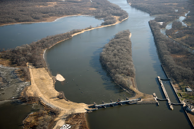
1935 Mississippi Lock and Dam #20 near Canton, MO

(John A. Weeks III; HAERSatellite)

USACE_instructions

"The maximum lift is 10.5 feet with an average lift of 5.3 feet....The movable dam has three non-submersible roller gates (20 feet high by 60 feet long), 34 non-submersible Tainter gates (20 feet high by 40 feet long), and six submersible Tainter gates (20 feet high by 40 feet long). The submersible Tainter gates submerge three feet." [USACE]

USACE, Rock Island District posted two photos with the comment:
Today we have another 'Then & Now'! This one takes us down to Lock and Dam 20 in Canton, Missouri. The first photo was taken in July of 1935 and shows construction of the steel forms that would later make up piers 8 and 9 of the dam.
The second photo was taken earlier this month [Oct 2024] and shows what the completed dam looks like today. Both photos were taken looking west towards the lock.
USACE, Rock Island District posted these two photos again with the comment:
Today [Jun 9, 2025] we wish a "Happy Birthday" to Lock and Dam 20 in Canton, Missouri! On this date in 1936, Lock and Dam 20 on the Mississippi River opened for operation. As only the second lock to go into operation on the Mississippi River within the Rock Island District, LD20 has been helping commercial traffic navigate the river for 89 years!
Robbie Quiller-Tallent: You used to be able to get so close that you could talk to the deckhands while they locked through.
1

2

Note the high river level. All of the gates are out of the water. There was flooding on the Mississippi in 2024. Some of the locks closed in July.
Street View, Jun 2024

In the only other comparable view available, we can't see the river level.
Street View, Jul 2012

And then it occured to me that I could get a different view to compare the river levels.
Street View, Jul 2012

Judging by the height and maintenance of the levees behind the tracks, there are times when those tracks are under water. According to the 2004 SPV Map, those are CB&Q tracks that are now used by BNSF and NS.
Street View, Jun 2024
 
The gates were also out of water in 2008, but the river level wasn't nearly as high on the lock walls.
Johns Weeks, 1 of several photos

Johns Weeks

David Webster posted two photos.
Mirandaandseth Wyman: Lock 20 Canton Missouri
1
[The river is still running high on Jul 23, 2024]

2

NOAA

Those trees on the right are near the westernmost point of Illinois.
Street View, Jun 2012

David Webster posted
Mirandaandseth Wyman: Lock 20 canton missouri
[The grain elevator in the background on the other side of the river is Ursa Farmers Co-Op Co.]

Tuesday, July 9, 2024

1916,1947 UP/C&NW+CPKC/Milwaukee Bridge over Mississippi River in St. Paul, MN

(no Bridge Hunter? no Historic Bridges; John A. Weeks IIISatellite)

This is one of the flood incidents of 2024.

According to a topo map and John Weeks, this is UP/C&NW/Minneapolis, St. Paul & Pacific (Omaha) and CPKC/Milwaukee Road. The locals refer to it as the Omaha bridge. A more official name is River Bridge #15. John explains that this structure was one of the original 15 bridges to span the Mississippi River. The first crossing here was built in 1869, and it was a wooden drawbridge.
 
River View, Aug 2016

A bobtail bridge always has a counterweight on the short end to balance the bridge over the pivot.
JohnWeeks
The bridge is 1,055' (322m) long with a navigation channel of 160' (49m).
"Despite a fair number of trains using this crossing, the bridge is maintained in an open position except when trains are using the bridge. The unusual feature of the swing span is that the pivot point is not in the middle of the bridge. Rather, the river section of the swing span is 185 feet [56m] long, while the other side is only 75 feet [23m] long. This feature is called an asymmetrical swing bridge [or bobtail bridge], and it is the only bridge like it on the Mississippi River.According to a local legend, once the bridge was erected, the owner of the land adjacent to the rail line objected to having the bridge swing over his land. To solve the problem, the railroad simply cut off that part of the bridge, and balanced it out with the large concrete slug that hangs off the back end of the swing span. The real reason for the non-symmetrical swing span is that the navigation channel is so close to the shore. The result is that half of the swing span would swing over dry land, so why span that dry land with expensive steel when cheap timber and cheap concrete would do the trick?
[John also describes the corporate history of the bridge.]

Another view of a normal river level.
JohnWeeks

Becky Haag posted two photos with the comment: "I finally got a fairly decent photo of the asymmetrical 1915 Omaha Swing Bridge and the approach in St. Paul this fall on a Padelford Riverboat cruise. It's still used by UP and we got a wave from the bridge tender."
1

2

Andre Wehrle commented on Becky's post
Nice. I got some shots of it in 2021 also from a Padelford boat.

Becky Haag commented on her own post
My dad hit the jackpot on one of his rides. The river was low enough that they could make it without opening the bridge, but he said it was pretty close. He'd never seen the bridge closed, let alone have a train go over them.

.

Flood of 2024


Compare the height on the piers to the river view at the top of these notes.
19:31 video @ 6:46


Sunday, May 19, 2024

1966+2026 I-270 Chain of Rocks Bridges over Mississippi River north of St. Louis

(Satellite)

Now we are tearing down UCEBs (Ugly Concrete Eyesore Bridges) as well as truss bridges.

[I lost the Google Maps link.]

This was construction of the 1966 bridge. It took vehicle traffic off the 1929 Chain of Rocks Bridge.
Bridges Now and Then posted
"The new I-270 Chain-of-Rocks Bridge being built across the Mississippi River just north of the old Route 66 Chain-of-Rocks Bridge in North St. Louis, Missouri - 1965" (Jim)
Ralph Mayse: Almost 60 years later, it's replacement is being constructed.
Dennis DeBruler: Ralph Mayse https://www.270mrb.com/CameraViews

Ralph's comment caused me to dig deeper. They are building a new bridge south of the existing bridge. Then they will replace the existing bridge. Both bridges will be able to carry 3 lanes of traffic in anticipation of projects to widen I-270 in Missouri and Illinois. The road currently carries over 51,000 vehicles per day, 17% of which are trucks. [TheIntelligencer]
The new bridges will cost about a half billion dollars. Construction is expected to be complete in 2026. [illinois]
Satellite

270mrb_Announcements, May 2023, cropped

270mrb_CameraViews, Camera #1: View #3

270mrb_CameraViews, Camera #2: View #1

Randy Perkinson posted
Chain of Rocks Bridges over the Mississippi River
Saint Louis, Missouri, USA 
This photo shows the ongoing construction of the new Chain of Rocks Bridge carrying I-270 across the Mississippi River between Missouri and Illinois.  The existing structure was built in 1970 and is functionally obsolete and in disrepair.  The photo is taken from the Old Chain of Rocks Bridge just downstream that carried vehicles from 1929 until 1970 and was converted for pedestrian and cyclist use in 1999.