(
Satellite)
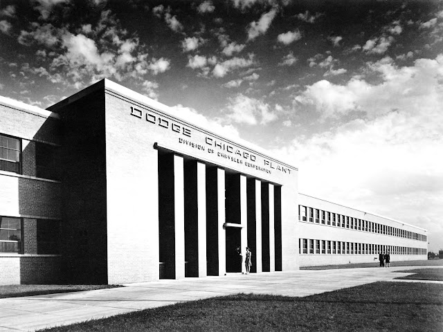
An alternative title could be (Tootsie Roll+Ford City Mall)/Ford/Tucker/Dodge Plant in Chicago, IL.
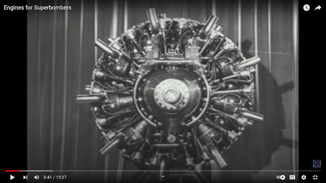 |
15:27 video @ 0:41
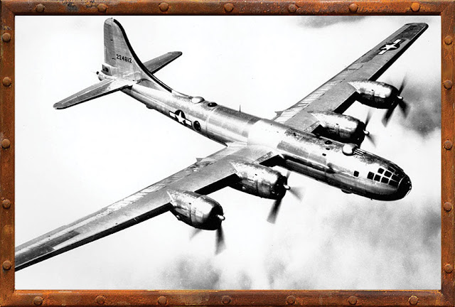
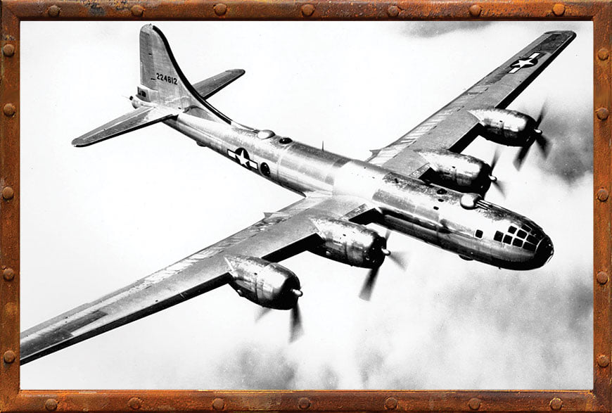
The Write R-3350 radial 18-cylinder, 2,200hp engine powered the B-29 Superfortress Bomber.
From 1942-44, Dodge built a plant that was designed to build 1,600 engines a month. |
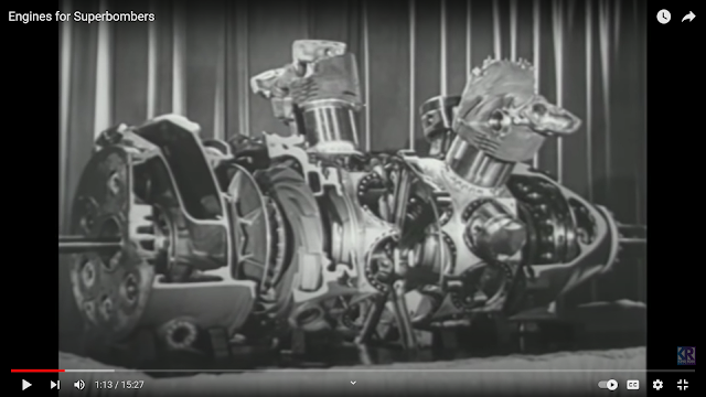 |
@ 1:13
The engine consisted of two 9-cylinder banks.
30,000 people worked here during its peak production. [14:39] |
Bob Beccue
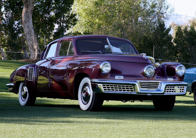
posted three photos with the comment: "1947-49.Tucker Auto Plant at 7401S. Cicero Ave. Originally a B-29 bomber engine plant.about 51 cars were built there.The pins are workers ID badges. (Preston Tucker gave them to my dad after the plant closed)."
John Strong: Tucker was so far ahead of the big three! So many things that we take for granted.What might have been.
Thomas Conforti: Ruined by lies, jealousy, fear and propaganda . A true innovator ahead of his time. That's why he was feared.
Modewon Gee: There is a Tucker @ The Laporte County Indiana museum just South of town. Great museum
 |
| 1 |
 |
| 2 |
 |
| 3 |
 |
Steve Tremulis commented on Bob's post
Tucker designer, Alex Tremulis, in his studio at the Tucker plant in 1948. Inducted into the Automotive Hall of Fame in 1982 and 2014! |
 |
Steve Tremulis commented on Bob's post
Your dad probably owned Tucker #1043, and he used it for many years at the driving range to promote his facility. He had it painted pink and white to match the theme of the range. His car was restored and sold at auction for a still record high sales price at just over $2.9 million in 2013. Did he ever talk about the car? |
 |
Michigan Explore posted
Preston Tucker was born on September 21, 1903, on a peppermint farm near Capac, Michigan. His father was a railroad engineer named Shirley Harvey Tucker (1880-1907). His mother was Lucille Caroline (née Preston) Tucker (1881-1960). He grew up outside Detroit in the suburb of Lincoln Park, Michigan. Tucker was raised by his mother, a teacher, after his father died of appendicitis when Preston was two years old. First learning to drive at age 11, Tucker was obsessed with automobiles from an early age. At age 16, Preston Tucker began purchasing late model automobiles, repairing/refurbishing them and selling the cars for a profit. He attended the Cass Technical High School in Detroit, but he quit school and landed a job as an office boy for the Cadillac Motor Company, where he used roller skates to make his rounds more efficiently. In 1922, young Tucker joined the Lincoln Park, Michigan, police department (against the pleas of his mother), his interest stirred by his desire to drive and ride the fast, high-performance police cars and motorcycles. His mother had him removed from the force, pointing out to department officials that at 19, he was below the department's minimum required age. Tucker and his new wife, Vera (married in 1923 at 20), then took over a six-month lease on a gas station near Lincoln Park, running the station together. Vera would run the station during the day while Preston worked on the Ford Motor Company assembly line. After the lease ran out, Tucker quit Ford and returned to the police force again, but in his first winter back he was banned from driving police vehicles by the force after using a blowtorch to cut a hole in the dashboard of a cruiser to allow engine heat to warm the cabin. During the last couple of months at the gas station, Tucker began selling Studebaker cars on the side. He met an automobile salesman, Michael Dulian, who later became sales manager for the Tucker Car Corporation. Dulian hired Tucker as a car salesman at his Detr [the source stopped there] |
 |
Dr Engines posted
This engine is the remarkable Tucker 589, an experimental powerplant developed in the late 1940s for the innovative Tucker 48 automobile, also known as the “Tucker Torpedo.” Preston Tucker, the visionary behind the project, sought to revolutionize American automotive engineering by designing a car that was decades ahead of its time. To match the car’s radical design, the Tucker 589 engine was conceived as an equally groundbreaking power source — air-cooled, fuel-injected, and capable of direct torque conversion without a conventional transmission. The 589 cubic-inch flat-six engine was unlike anything used in production cars of the era. It featured hemispherical combustion chambers, overhead valves operated by oil pressure instead of a camshaft, and a torque converter system integrated directly with the crankshaft. Rated at a theoretical 150 horsepower and over 400 lb-ft of torque, it promised smooth, silent performance with very few moving parts — a concept inspired by aircraft engineering. Tucker envisioned it as a durable, maintenance-free engine for his futuristic sedan. Despite its innovation, the 589 proved too ambitious for mass production. The hydraulic valve system proved unreliable, and the lack of a traditional transmission made it difficult to refine for everyday driving. Ultimately, the Tucker team pivoted to using a modified Franklin O-335 aircraft engine, converted to water cooling for road use. However, the 589 remained an extraordinary glimpse into what could have been — a daring blend of aviation technology and automotive design philosophy. The engine on display today serves as a symbol of Tucker’s bold engineering spirit. Its exposed mechanical design, distinctive dual exhaust layout, and unique architecture highlight how far ahead of its time the project truly was. Even though the 589 never powered a production Tucker, its legacy endures as one of the most fascinating “what-ifs” in automotive history. In the grand narrative of innovation, the Tucker 589 stands as a testament to risk-taking and creative vision. It represents a period when engineers dared to defy convention — to imagine an automobile not bound by tradition, but driven by the future. Eli Whitney: For "ALL" -{believers and nay-sayers alike}- please DO visit the Extraordinary TUCKER Exhibit in Museum of Hershey, PA ... full Vehicle, various engines, transmissions, prototypes, etc.. John Wyma: Eli Whitney Yes at Hersey they have both the Franklin 0-335 engines and the Tucker 589 engines. Visitors can learn of the 589 failures and the 0-335 success. |
 |
MattStoneCars via FRRaP
[This building was the office building that fronted Cicero Avenue. Most of that land is now a parking lot.]
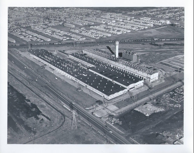
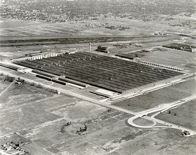
Buildings were built on a 500 acre "green field" that enclosed 6 million square feet or almost 140 acres. "It was the world's largest building at the time." At the end of WWII, production stopped and the machine equipment was sold off as military surplus. Preston Tucker then leased the facilities to design and produce his 1948 "Torpedo." But after just 52 cars were built, the plant was closed in 1949.
[I've seen the claim of the "world's largest" in several sources. But I don't know if they mean the big building or all of the buildings.
This article claims that the B29 was built here. That is wrong. It was the engine that was built here. The B-29s were evidently built in Boing's Kansas City plant. 4000 airplanes were built. Five engines were built for every airplane so that there would be spares. 5*4000*18=360,000 cylinders.] |
Dan Nocchi
posted five photos with the comment:
In order to build his dream car, Tucker needed a place to begin working. An old Dodge plant in Chicago caught his eye. He leased the plant and rapidly began building the Tucker ’48 prototype. The plant itself covered 475 acres, but the main building covered 93 acres.
Too bad the big three and the feds shut him down!
Thomas Conforti: If the big three hadn't rigged things against him out of fear of the superiority of the Tucker over their cars. He probably would have been the biggest. All the lies about him that still exist today are a joke.
 |
| 1 |
 |
| 2 |
 |
| 3 |
 |
| 4 |
 |
| 5 |
 |
Eliseo Carrillo posted
The assembly line for Tucker 48 automobile engines at the Chicago plant in 1948.
Steven Cutler: Tucker bought Franklin Motors for their air cooled engines made for Bell Helicopters. They switched all production for the 52 cars they produced ignoring the government contracts they had to produce helicopters which could have been a cash cow for the cash strapped company. Ryan Tuttle: Tucker bought the Franklin engine company which was going into receivership. The had an air cooled vertical flat 6. Tucker modified the flat six to horizontal added water jackets with intake runs and a down draft carburetor. The Franklin motor did well in testing and propelled the 48 Tucker to over 120mph. |
After Tucker, Ford used the plant to make a different airplane engine.
 |
David M Laz posted
A view of the biggest industrial plant in the world, the Dodge Chicago Plant at 75th and Pulaski Road on Sept. 9, 1945. By 1950, the Ford Motor company would be making 28 cylinder Pratt and Whitney Wasp Major engines for use in Air Force planes. — Chicago Tribune historical photo |
 |
| 1953 Englewood Quad @ 24,000 |
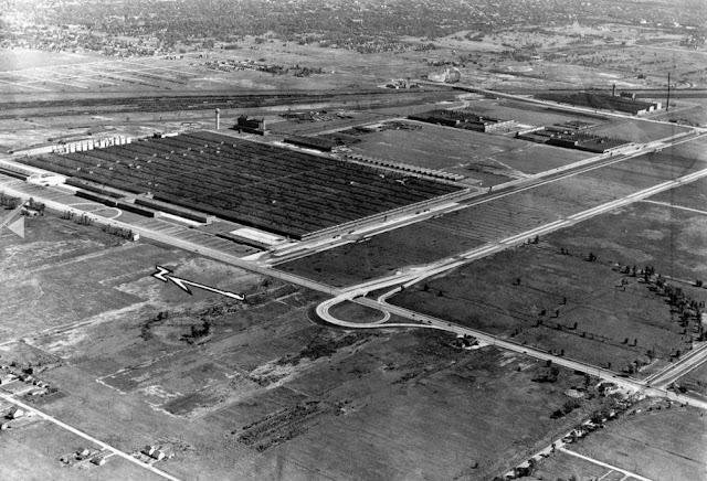
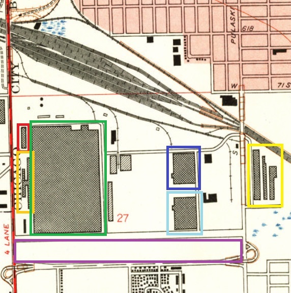
In June 1942, the first building erected was the tool shop (the red rectangle in the northwest corner of the campus). "Over a million-and-half tools, jigs and fixtures were needed." And then the office buildings (orange) were built so the initial staff in Detroit could move to the location. On the opposite side of the campus, a die shop and forge division was built (yellow). An aluminum foundry was built to make the cylinder heads (dark blue) and a magnesium foundry was built to make the required magnesium castings (light blue). The big building (green) was for machining, assembly and testing. The parking lot (purple) could hold 13,000 cars. [@
1:42]
 |
| 1953 Englewood Quad @ 24,000 plus Paint |
This is just the forging part of the complex and this part did not become Ford City.
 |
James Stein posted
Ford City 1960, photo scanned from my dad's collection.
Jim Smith: My grandfather worked for Ford aircraft engine until they closed the plant in '59. |
Some of the forge buildings are still standing, but the smokestack has been truncated.
Three photos
posted by Gail Bob McCabe.
 |
| 1 |
 |
| 2 |
 |
| 3 |
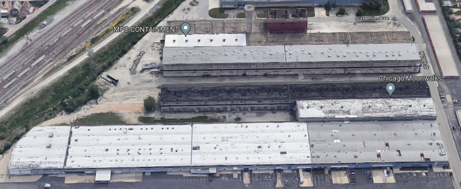
So Ford vacated the buildings in 1959. [Jim Smith's comment on James Stein's post above.] Now I became confused because some Facebook comments say the building became Ford City Mall and other comments say it became Tootsie Roll. By looking at some topo maps, I concluded that both comments are right. The southern part of the big building was torn down to make way for the mall. Tootsie Roll moved into the northern part of the building in 1967 [The date is from a Thomas F Tedesco's comment on a
post].
 |
| 1972 Englewood Quad @ 24,000 |
I came across the following two posts about Tootsie Roll in two days, and that is what motivated me to dig into the history of this building.
.jpg) |
Thomas Cook posted
Driving past Tootsie Roll today and I always wonder why the building was built like that and what those structures are/were for?
[I presume the concrete structures above the roof were part of the test stands.
More than 13,000 parts went into an engine. Then an engine ran on one of the 44 test stands driving a generator for four house at various speeds. (Testing generated about $25,000 of electricity each month.) Then an engine was taken apart so that all of the parts could be inspected! Then the engine was reassembled and had a final test. [11:52]]
|
Thomas Cook was driving down 72nd Street.
 |
Historic Chicago posted
Inside the Tootsie Roll Factory in Chicago. (1960s)
[Many comments referenced a I Love Lucy show and some comments mentioned the beehive hairdo.]
Heather Iffland: My friend and former coworker from another job is the current SQF Practitioner at Tootsie Roll. It used to be an airplane factory during WW2. It’s over a million square feet. He says they have a golf cart to get around. An SQF audit at my work takes a day and a half for 2 buildings and about 150,000 sq feet of building. Their audit takes 5 days.
[I Googled SQF Practitioner. There were a lot of results about SQF training and certification. I finally found "Safe Quality Food (SQF)." The code is up to Edition 9.]
Colleen Blackburn shared |
When I looked at the former magnesium foundry building, I thought it had been replaced because it looks rather modern. But when I watched the video I realized that the architect did build some rather modern looking buildings. So now I believe that this is one of the original buildings. This "little" building looks rather large.


.jpg)


.jpg)


.jpg)


