Thursday, June 30, 2022

1879+1908 (BNSF+Amtrak)/Santa Fe Raton Pass Tunnel

East Portal: (Satellite, just south of the NM-CO border)
West Portal: (Bridge HunterSatellite)

"Built 1879; second tunnel built 1908; original bore closed 1953." [BridgeHunter] It is the highest point on the Sante Fe at 7588' [UncoverColorado]

The Santa Fe and Denver & Rio Grande Western not only fought for the route through the Royal Gorge, they fought for this pass from Colorado to New Mexico. This was the Santa Fe's original route to California. But it has grades as high as 4% in Colorado. Santa Fe completed the 200+ mile Belen Cutoff in 1907, which has easier grades and is more direct. The now closed 1879 tunnel was 2,041' long. The 1908 bore was 2,787' with an approach grade of 0.158% instead of the 1.9% grade for the original bore. [american-rails] Since BNSF has moved its through freight operations to the cutoff, it doesn't want to maintain this route for passenger speeds. But, of course, Amtrak does want BNSF to maintain it. That is why I added the Amtrak label to these notes.

East Portal:
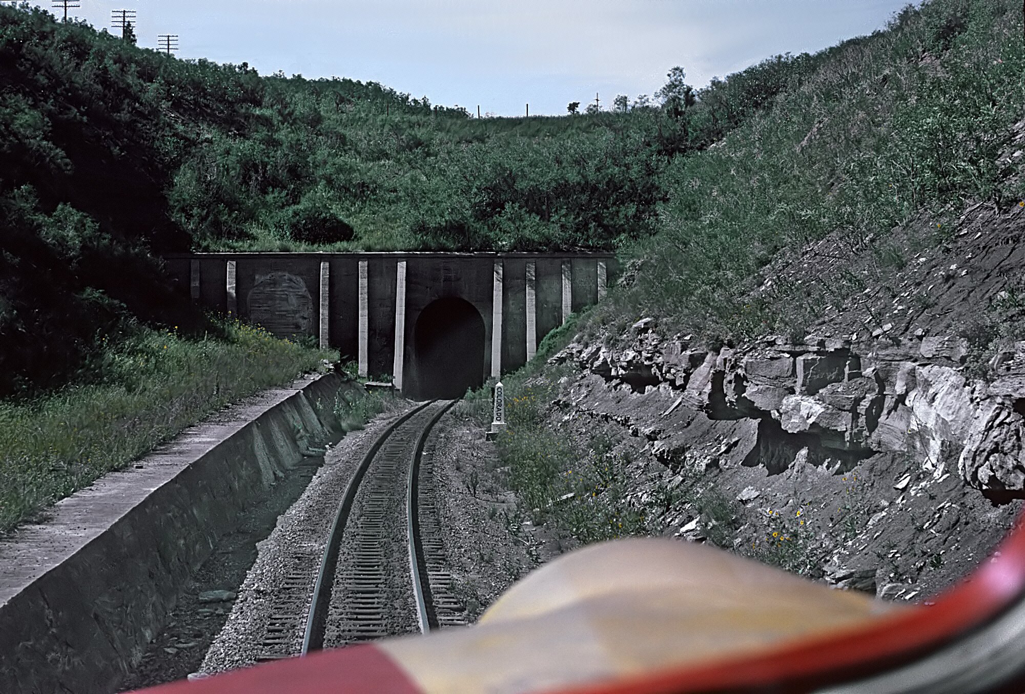
Marty Bernard posted
Raton Tunnel East Portal, Cab View
ATSF's Raton tunnel through Raton Pass, east portal, taken from cab of F7 309L pulling Train #23, the 𝘎𝘳𝘒𝘯π˜₯ 𝘊𝘒𝘯𝘺𝘰𝘯 near Wooten, Colorado (Colorado State Line marker) on August 19, 1967. Roger Puta photograph
Erich Houchens: I worked the Raton Desk (DS18) for five years 2012 to 2017. Still kicking myself for not taking a Road Trip and riding the headend of A3 and A4 over the pass. Of course the FRA rule against using cameras/cell phones on the headend would have prevented me from getting the same picture.

West Portal:
Hinge of fate, CC BY-SA 3.0, via Wikimedia Commons

Back when the original bore was still being used.
1929 CarterMuseum, Public Domain

A very different colorization.
Illinois Central Railroad Scrapbook posted
This postcard specifies an altitude of 7,622'.

american-rails
An A-B-B-A set of Santa Fe F3's have the "Super Chief" on Raton Pass in a publicity photo dated September 7, 1959. Roger Plummer photo.


Wednesday, June 29, 2022

Broadway (Young) Street Bridges over Milwaukee River in Milwaukee, WI

1903: (Bridge Hunter) I can't tell if this bridge was rolling or tunnion.
1982: (Bridge Hunter3D Satellite)

This bridge was raised 3,073 times in 2017. [UrbanMilwaukee]

Milwaukee has already converted its river from industry to, I'd guess, high-priced residences.
Street View, Sep 2021

I'd date this photo between 1890 and 1903 because that is when the first bascule bridge was built. Given the lake in the background and the location on the Milwaukee River, I think this was a Broadway Street Bridge. And today's Water Street Bridge must have been Clinton Street Bridge back then. Given the name "Clinton Street Antiques," 1st Street must have had a former name of Clinton Street.
Association for Great Lakes Maritime History posted
An undated photograph of Milwaukee, Wis. by the H.H. Bennett Studio looking down the Milwaukee River from Clinton Street. The tug Welcome is in foreground right and the Bethel House of the Wisconsin Seaman's Friend Society (est. 1868) is on the right (Image Source: Milwaukee Public Library Digital Collections). Based on the inclusion of the Welcome in the photograph, it would date the image to between 1890 and the early 1910s or 1920s.
[The description goes on to provide a history of Welcome.]

2:23 video @ 0:29 via Bing Owens share

Postcard via BridgeHunter-1903

Broadway Street now appears to be a parking lot and Catalano Square blocks its connection with the bridge.
Satellite

2010 J.R. Manning Photo via BridgeHunter-1982
East Elevation as seen from the north approach span to the C&NW Swing Bridge. In the distance, on the left edge of the photo, is the Menomonee River Swing Bridge.

"If you feel like you’re getting stuck more often waiting for a bridge to come down to cross the river, you’re right. In 2014, the city’s 21 movable bridges were raised 14,003 times to accommodate boat traffic. In 2017, that number had climbed — by 60 percent! — to 23,244 openings. The increase is due to a confluence of factors including higher Lake Michigan water levels, a strong economy and a growing number of waterfront businesses. The river level is up two feet since 2014, causing an increasing number of boats to require bridge openings to navigate the rivers." [UrbanMilwaukee] I noticed in the above video that the bridge kept going up long after the boat had passed underneath. That delays traffic even more.


Tuesday, June 28, 2022

1930,2013 Cherry Street Bridge over Ship Channel in Toronto, ON

(Historic Bridges; Satellite)


Historic Bridges reports that the trunnion was replaced as part of the 2013 rehabilitation.

Street View

It looks like a good sized boat is docked on the right.
Jonathan Konopka posted
This is the Cherry Street Bridge in Toronto, Ontario. It is a bascule bridge that was built in 1930 and carries Cherry Street over the Toronto Harbour Shipping Channel.

I got the 1930 build date from HistoricBridges. So is this 1918 date a different Strauss bridge?
Bridges Now and Then posted
Toronto's Cherry Street Bridge, 1918. A Joseph Strauss design, it was built by Dominion Bridge Company. (City of Toronto Archives)

Monday, June 27, 2022

1903 CP/Milwaukee Bobtail Bridge over Menomonee Slip in Milwaukee, WI

(Bridge Hunter; Satellite)

Street View from 6th Street
 
BridgeHunter

South 6th Street opened 24 times in 2017. [UrbanMilwaukee] But I doubt if any of that traffic came down to the south slip because the old flour mill or malt house looks closed.

Wisconsin History via BridgeHunter, License: Creative Commons Attribution-Share-Alike (CC BY-SA)

Bing Owens posted five images with the comment: "CP - Burnham Bridge in Milwaukee, WI today...A bobtail swing bridge over the Menomonee River...beautiful day for an outing..."
Dennis DeBruler: Per Wisconsin History,
"This counter-balanced swing bridge was built in 1907 by the American Bridge Company for the Chicago, Milwaukee & St. Paul Railway Company. Constructed of steel, the 203-foot-long bridge replaced an earlier wooden swing bridge, which dated to 1872 and had a clear opening of 49 feet. The Chicago, Milwaukee & St. Paul Railway wanted to replace the original bridge with one of similar dimensions; however, property owners in the area and the Merchants & Manufacturers Association successfully petitioned the Corps of Engineers to widen the canal, thus necessitating a larger bridge with a clear opening of 65 feet. The subject double-track bridge appears to be a variation of a Warren truss." - "Marquette Interchange, Milwaukee", WisDOT ID #1060-05-02, Prepared by Heritage Research (McQuillen) (2001). 2020 - The bridge rotates on a circular drum placed atop evenly spaced rollers, and is an example of a “bobtail” swing bridge, in which the bridge is not symmetrically centered over a swing pier, but instead has a longer end spanning the majority of the channel, and a shorter end anchored with a counterweight. A small operator’s shed, constructed of wooden frame with clapboard siding, is located along the north side of the bridge face.
1

2

3

4

5


Saturday, June 25, 2022

Lock #2 on Welland Canal at St. Catharines, ON

Lock: (Satellite)
Bridge: (no Historic Bridges; Satellite)

This is Lock #2 of the Welland Canal.

Street View, Apr 2021, looking downbound

It is clearly a rolling bridge.
Street View

Street View, Oct 2020

Street View, Jul 2012
 
MaritimeHistoryOfTheGreatLakes
Aerial photograph of Lock no. 2 with a canaler in the lock. The view looks north where in the distance Lock 1, Port Weller, and Lake Ontario can be seen.

Richard Haydon posted
Tugs Beverly M l and Amy Lynn D with the bridge bound for Toronto, stuck below Seaway lock #2 Cote Ste. Catherine, QC. due to a vehicle blocking the canal.
 July 1, 2022.
[Michel Demers commented on another post of this docked barge: "A car fell in the lock and close by, a ship ran aground 3 days ago. No signs of pulling it back in the seaway."]

Aug 14, 2023: Rob Shak Hartley posted
Waiting in lock 2,  lock 3 broken

Paul Ingram posted
Csl Tadoussac - Lock 2, Welland Canal - 1600x1200 px, 1.23 mb, 300 dpi - based on a photo by Bruce Jackson.
Bruce Jackson: Thank you, Paul. I love what you do with my photo.
[The river must be really high if water is coming over  the top of  the gates.]

Friday, June 24, 2022

1834-1892-1932 Delaware and Raritan (D&R) Canal Overview

Construction began in 1831, and it opened in 1834. The last profitable year was 1892. (There was an economic panic in 1893.) 1932 was the last year of operation. New Jersey took ownership in 1936. The canal still has water because it was repurposed in the 1940s as a water supply. (For about a million customers in Central New Jersey. [CanalSocietyNJ]) In 1974, 60 miles of the canal was turned into a linear state park. [see "+ Historic Canal" below]

CanalSocietyNJ
The 22-mile branch to Bull's Island was originally a feeder canal. But a towpath was added to facilitate moving coal from Pennsylvania to New York City. The main route was 44 miles. The canal was relatively level with only fourteen 24'x220' lift locks. "The locks were operated by steam-powered winches and valves after 1868....Boats from the Schuylkill Canal and the Delaware Canal, both in Pennsylvania, used this waterway....The canal was a link in the Atlantic Intracoastal Waterway, a link that is missing today. One of the most interesting aspects of the Delaware & Raritan Canal was the large variety of boats that passed through it. Theses included mule-towed canal boats and sailboats, steam tugs towing barges, freight boats, luxury yachts, and naval vessels. Canal boats from most of the canals on the East Coast traversed the D&R." The railroad was originally the "Camden & Amboy Railroad, the precursor of the Pennsylvania Railroad."

I wonder if this is the longest historic (built in 1830s or 40s) canal that still is watered. The Erie canal has been rebuilt, at least once. Indiana & Michigan Canal, Wabash & Erie and Whitewater Canals and Miami & Erie Canal have water left in just some tourist|scenic sections. Although some of those sections have become stagnant algae messes. One advantage of the D&R Canal now being a water supply is that the water is not stagnant.

NewJersey
"Click here for a more detailed history of the D&R Canal"

DandRcanal-locks

Photo via CanalSocietyNJ-gallery
Because of its large locks and lack of inclines, the D&R was more successful than the Morris Canal. In addition to being less of a hassle to use because of fewer locks and no inclines, many types of boats could use this canal, not just canal barges.

Link

The state park consists of the feeder canal and the main canal between the feeder canal in Trenton and New Brunswick. [TrailMap]

So far, the only detail for which I have written notes is the Alexauken Creek Aqueduct.

Thursday, June 23, 2022

2000 US-68 William H. Harsha Bridge over Ohio River near Aberdeen+Maysville

(Bridge Hunter; John A. Weeks IIISatellite)

This bridge and a new bypass highway opened in 2000 so that the 1931 suspension bridge that is a little upstream from here could be closed for rehabilitation. And trucks over 15 tons still use this bridge instead of the old one.

2008 Photo by Kentucky Transportation Cabinet

This bridge was built after the problem of cable vibration was well understood. Many earlier cable stayed bridges had problems with the stay cables vibrating during light rain showers. Older bridges had to be retrofit with a dampening mechanisms. On the Harsha Bridge, the cables were encased in a plastic tube. That tube has a small ridge on it that spirals around the tube for its full length. The ridge provides a small amount of lift that disturbs the air around the cables just enough where the vibration will not get started. This was an extremely cheap solution to a problem that has proven to be very costly to some earlier cable stayed bridge operators.
William H. Harsha was a Congressman from Ohio from 1961 to 1981.
[JohnWeeks]

2010 Photo by Kentucky Transportation Cabinet

A better exposure of a cable connection.
2010 Photo by Kentucky Transportation Cabinet

The new bypass highway includes a significant cut on the Kentucky side.
Street View

I wonder why a bridge that is just 20 years old has "cabling and other deficiencies."
PeoplesDefender
"Repairs are expected to take place in 2023, according to information from KYTC. The two area bridges that span the Ohio River were among bridge projects included in Governor Beshear’s proposed budget with $8 million to address cabling and other deficiencies in the William Harsha Bridge and $23.4 million designated to rehabilitate the Simon Kenton Memorial Bridge which connects downtown Maysville to its Ohio neighbors. Improvements to the Simon Kenton Bridge include suspender cable replacements, steel repairs, and painting, KYTC spokesperson Allen Blair said."


Wednesday, June 22, 2022

1931 US-62 Simon Kenton Bridge over Ohio River at Aberdeen+Maysville

(Bridge HunterHistoric BridgesB&TSatellite)

A cable-stayed bridge was built downstream from here for a bypass highway. Both US-62 and US-68 were moved to the new highway while they closed this bridge for rehabilitation. Technically, US-62 has been moved back to this bridge, but trucks over 15 tons still have to use the bypass highway.

Looking upstream from the Kentucky side. In the distance, around the bend, is the JM Stuart Power Plant.  Once again, I'm thankful for Kentucky's support of fishermen. In this case they built river access on the other side of the flood wall. And for some street view drivers who are willing to get off the beaten path.
Street View

Looking downstream from the Kentucky side. With this link, you can zoom in on the cut-stone pier.
Street View

C Hanchey Flickr, cropped, License: Creative Commons Attribution-NonCommercial (CC BY-NC)

The towers have the X-bracing that is characteristic of Modjeski and Masters designs. John A. Roebling Sons erected the superstructure as well as fabricate the cables. "The bridge retains excellent historic integrity with no major alterations noted." [HistoricBridges] I'm glad that Ohio and Kentucky are willing to tolerate suspension bridges since they seem to be on a mission to destroy truss bridges.
Street View

The last of five photos posted by Bridges & Tunnels with Sherman Cahal
Sunny or cloudy, the historic Simon Kenton Suspension Bridge that links Maysville, Kentucky, and Aberdeen, Ohio is always a stunner. The wire suspension crossing opened in 1931.
➵ Check out more photos and history of the Simon Kenton Suspension Bridge at http://bridgestunnels.com/location/simon-kenton-suspension-bridge/
Larry Klug: It kind of reminds me of a miniature San Francisco Oakland bay bridge.
Monty Fulton: This bridge is actually a model of the Golden Gate Bridge, built first to prove the design worked.

The flood wall blocked my view of the anchorage so I didn't notice them until I saw this photo.
FreightWaves
A view of the Simon Kenton Memorial Bridge in 1933. (Photo: nkyviews.com)
"The Simon Kenton Memorial Bridge was closed for rehabilitation in 2003 and 2004, which included a “deck replacement, structural steel repairs, a new inspection walkway, and a new handrail on the main spans.” In addition, the bridge was painted silver, its original color. At a cost of $5.7 million, National Engineering and Contracting Company completed the rehabilitation construction and painting.

Fast-forward to July 2019; the Kentucky Transportation Cabinet [KYCT] ordered a 3-ton weight limit on the bridge after a routine inspection found “significant safety hazards” in the cable suspension system. The bridge was closed due to corrosion in the suspension cable connectors in November 2019. Then in May 2020, the bridge closing was extended after an inspection of the cable repairs determined that the bridge needed rust-proofing.

The bridge reopened for traffic with a 15-ton weight restriction on June 12, 2020. However, the bridge continues to need major rehabilitation, including replacing all  cables."
[The 2004 silver paint job caused more harm than good?]

PeoplesDefender
"Repairs are expected to take place in 2023, according to information from KYTC. The two area bridges that span the Ohio River were among bridge projects included in Governor Beshear’s proposed budget with $8 million to address cabling and other deficiencies in the William Harsha Bridge and $23.4 million designated to rehabilitate the Simon Kenton Memorial Bridge which connects downtown Maysville to its Ohio neighbors. Improvements to the Simon Kenton Bridge include suspender cable replacements, steel repairs, and painting, KYTC spokesperson Allen Blair said."

nkyviews has several more historical photos. I picked this one because it shows that the river level used to be significantly lower.
nkyviews
Before the current locks and dams.