Showing posts with label rfPazdzior. Show all posts

Friday, July 8, 2022

1920 BNSF/CB&Q Hurds Island Bridges over Fox River in Aurora, IL

East Channel: (Bridge Hunter; Historic BridgesJohn MarvigSatellite)

These bridges carry the BNSF/CB&Q mainline over the Fox River. An abandoned bridge for an industrial spur is just upstream from these bridges. And the Fox River bridge for the IR/CB&Q Streator Branch is downstream of these bridges.

A photo of the downstream side of the West Channel Bridge from a trail bridge.
20170401 8350

An "artsy" photo, but it is more useful as a memory aid photo to remind me that I shot it from the trail bridge.

I had a hard time finding a clear view of the bridges because there are trees along the shores of Hurds Island. This is the East Channel Bridge. Note some leaves of the trees are in the river. I made this field trip because the local rivers were running high.
20170725 0614

This is the West Channel Bridge. Note the river was almost on the trail. There were parts of Hurds Island that were under water. In fact, the drive to the parking lot on the island was closed during this trip.


HalstEd caught the river during a more normal flow. Note the extensions on the north side of the pier. They were covered in my July 25, 2017, photo because of the high river level. The extensions must be more than just ice breakers. I presume that they help the current in the river to use the east and center parts of the river rather than pile up against the west bank and cause erosion.
HalstEd Pazdzior posted
RCHI476 over the Fox River.  7/7/22
[Not only did he catch a Blue Bonnet, the BNSF loco is H1.]

Note that during the Apr 1, 2017, trip the river level was right at the top of the extensions. I was able to park on Hurds Island during this trip. (I don't know why the exposure is so dark. Did I catch a lot of glare off the river?)
20170401 8354

Since the leaves were still off the trees, I got a little more of the East Channel Bridge.

On the July 25, 2017, trip, I caught a train going across the East Channel


The train continued to roll across the bridge as I walked on Hurds Island from the east side to the west side. Note the water under the swings because the river was running high.

Jeff Wojciechowski posted
[On the west side of Hurds Island on the downstream side.]

Chuck Pfeiffer posted two photos with the comment: "Saw this parked on the Fox River bridge just south of downtown Aurora earlier this week. That's a horrible spot to park. The bridge has crumbling concrete."
1

2
[This would be the downstream side of the West Channel. HistoricBridges-west points out that this bridge is skewed.]

Dave Kuntz posted
The massive BNSF concrete viaduct over Hurds Island and the Fox River in Aurora.  Looks like it was triple tracked once?  Also note the abandoned EJE bridge in the far background.
Steven E Kakoczki: Yes.....at Hurds Island it had three tracks. Two of them went to Galesburg and one went west....known as the C&I Main.
[Some comments indicate that the C&I Main is now called the Aurora Sub.]
Harold J. Krewer: Employees also prefer to call Chicago-Aurora the "East End," NOT the "Racetrack." "Racetrack" is strictly a foamer term. On the radio today it's STILL the "East End Dispatcher" (along with Union Ave. Dispatcher on first and second trick).
Three mains once extended all the way to where the C&I (Aurora Sub) and the Main Line (which becomes the Mendota Sub at Montgomery) split. When the dinkies were rerouted at West Eola down the hill to the new Transportation Center, the third main got pulled up west of there.
Wonder if anyone in Fort Worth regrets that decision today.
Rufus Xavier Sarsaparilla: It’s actually two separate bridges. One over the east channel of the Fox River, one over the west. The west bridge has 3 tracks still, Main 1 & Main 2 westward towards Galesburg and the Aurora siding. The turnout to the C&I Main is over the River St Viaduct, the turnout out to the Sheepyard lead is off the C&I Main just west of River Street. The C&I Main goes west towards Sugar Grove, Rochelle and Savanna in IL on the Aurora Subdivision. The two Galesburg Mains are on the Chicago Subdivision.
Davis Shroomberg: The triple track you refer to on the east bridge was the main lead into the former CB&Q Aurora station, which is also where Q/BN/Metra dinkies would lay over before being moved to the current Metra station at the Roundhouse circa 1988.
Steven Holding: Constructed 1917-1932 with time out for WW! Three tracks to just past the bridge at top over the fox where split 2 to Galesburg middle to the Sheep Yard Now the industrial tracks along Ill. 31 and 1 to the C&I to Savanna with the start of the C&I Siding off to the right. OP Aurora Tower 6/73-12/31/73 Dispatcher Cicero till move to Galesburg then Ft. Worth.

Larry Candilas commented on Dave's post
Lots of tracks in 1967 - definitely three across the bridge


Sunday, March 13, 2022

BNSF/Santa Fe Bridge over Des Plaines River in Lyons, IL

(Satellite, BNSF/Santa Fe is the southern bridge. The northern bridge is the C&IW)

ATSF Des Plaines River 4/87
This is the site of the original Chicago Portage which enabled small boats and canoes to go between the Great Lakes and Mississippi water systems. This geographic feature is the reason Chicago became a great transportation center.
 
MWRD posted on Oct 26, 2022
A view of the newly built Santa Fe Railroad bridge over the Des Plaines River between Lyons and Forest View with a passing train "...running full speed" on April 13, 1899.

Andy Zukowski posted
Santa Fe tracks near Lyons, Illinois overflowed by the Des Plaines River 1909

MWRD posted on Mar 4, 2022
Construction of the Santa Fe Railroad bridge over the Des Plaines River between Lyons and Forest View on November 15, 1898. The bridge was one of many the Sanitary District (now MWRD) built during construction of the Chicago Sanitary and Ship Canal. 

From the 47th Street Bridge, the Santa Fe Bridge is obscured by the C&WI Bridge.
Street View

HalstEd Pazdzior posted, this photo has been moved to
"BNSF/Santa Fe Bridge over Des Plaines River in Lemont, IL."


Wednesday, October 14, 2020

UP/C&NW 1927 Bridge over Fox River in Fox River Grove, IL

(Bridge Hunter; no Historic Bridges; John Mavig3D Satellite)

Street View

HalstEd Pazdzior posted
Here's another one from the other day, but at water level. Metx 90 and 402 shove an inbound over the Fox River.
10/7/20
[The yellowish unit would be Metra's C&NW heritage locomotive.]

Saturday, August 29, 2020

KB&S/(Big4+NKP(LE&W)) Bridge over the Wabash River at Lafayette, IN

(Bridge Hunter; no Historic Bridges; 3D Satellite)

KB&S = Kankakee, Beaverville & Southern Railroad

I've seen this view a few times but ignored it because it is yet another truss bridge. But I've decided that about the third time is a charm.

HalstEd Pazdzior posted

"Through Truss 2 Track bridge(currently single track) once shared by the New York Central and Nickel Plate railroads. Reconfiguration of adjacent SR 26 and CSX and NS tracks forced realignment of East approach causing removal of 1 track." [BridgeHunter]
Indiana State Department of Natural Resource, Division of Historic Preservation and Archaeology via Bridge Hunter

Cape Cod And Islands Railroads And Trains History posted
New York Central Railroad Lines Bridge Lafayette, Ind.
- Circa 1909
Seth Lakin: This bridge over the Wabash River is still in use today, although single tracked and one of the deck girder bridges on the east bank (off frame to the right of the photo) has been removed to allow for a tighter curve for the 1990’s Lafayette Railroad Relocation Project.
Tim Shanahan shared

Journal and Courier: February 12 1959 via Bridge Hunter


Ray Gray posted
The Big Four Railroad took a trainload of passengers to West Lafayette moments before the Main Street levee broke, sending the river slamming through the bottom lands and further endangering the city of West Lafayette. Loaded coal cars were pulled onto the bridge. The added weight kept it from being swept away. but it was knocked five inches out of line by floating buildings. History does not precisely define the "fluffy-ruffle brigade", but when the railroad bridge was the only connecting link between the two towns, ingenious Purdue students jumped from coal car coal car to get across the flooded river to visit their girlfriends in Lafayette. Before the river subsided, the on-rushing waters washed out foundations beneath the piers, leaving the bridge suspended, and it also had to replaced.
[Flood of 1913]

Dave Cobb shared

Lew Morris commented on Ray's post
From the Journal & Courier, 1913 https://www.jconline.com/.../february-1913.../79592740/ Note that the little ferry is powered by a paddle wheel. 15 more photos on the link.

Lew Morris commented on Ray's post
Ol' Wabash is looking more little O'Miss.

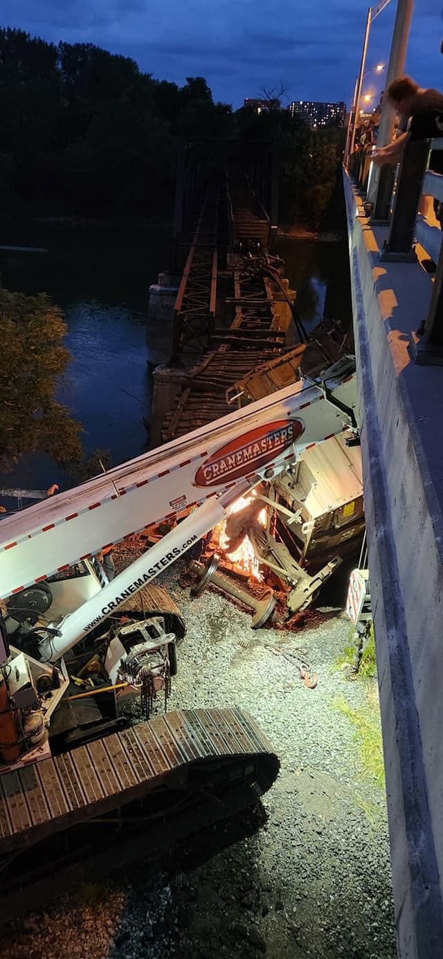
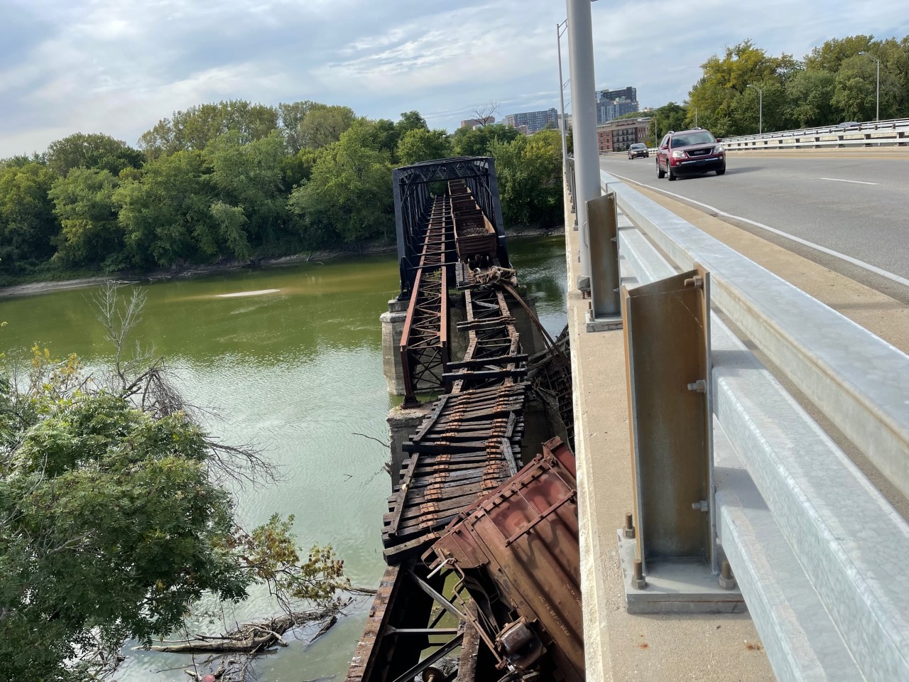
Sep 21, 2022 Derailment


C Kent McKenzie posted seven photos with the comment: "Derailment today (9/21/2022) with significant damage to this old bridge in Lafayette, IN. This is a spur that runs west from the NS mainline, just south of the Amtrak station, next to the South Street bridge. I've seen speculation in other groups that this won't be repaired, as there is an alternate rail route to the served industries. Photos by Clayton St Martin."
1

2

3

4

5

6

7

Brian Pruitt posted four photos with the comment: "Lafayette Indiana:  Kankakee, Beaverville and Southern Railroad. Tracks failed while pushing rail cars for storage. I formally nickelplate, conrail then NS rail bridge."
Eric DeHaan: How many cars got across before it fell in? Going to be interesting getting that fixed/who fixes it and get the cars back lol.
Brian Pruitt: Eric DeHaan I haven’t gone down there yet, but looks like three railroad cars that Norfolk Southern was going to store on kbs rail line for the Nucor steel plant in Crawfordsville.   Now it’s Norfolk Southern’s bridge and owns X amount of feet on the other side. It will be NS that will fix it.
Dan Kleinhenz: Looks like they were loaded with pig iron briquettes.
1

2

3

4

Brian Pruitt commented on his post
Where is his hard hat at?

WISH-TV posted six photos with the comment: "BREAKING: A train derailed Wednesday afternoon on a Wabash River bridge on the border of West Lafayette and Lafayette, the Lafayette Police Department says. What we know: https://bit.ly/3S1IQkz?utm_medium=social..."
(Provided Photos/Jeff Ooms)
Michael Perigo shared
1

2

3

4

5

6


Saturday, June 20, 2020

Goff Junction: EJ&E vs. South Shore and City Track

(Satellite)

George M Stupar posted
1980 Gary IN, Monstrous 88' 10" electric freight motor 803 is seen working at Goff on Gary's east side.
Miguel Chairshiseetos Class 800 or Little Joe
R. Scott Sulich Miguel Chairshiseetos both
Dennis DeBruler I learned of Goff and the junction with EJ&E's City Track just a couple of weeks ago. It is nice to see what it looked like.
https://www.google.com/.../@41.5962972,-87.../data=!3m1!1e3

Charles Rothbart posted his Flickr photo
Two years ago when I was in Chicago we shot a westbound coal train with UP power on the South Shore Railway in Ogden Dunes. I assume this was coming from the NIPSCO plant in Michigan City. How was this train routed past where we shot it? I'm not aware of an obvious connection from the South Shore to the UP, but I could be missing something.
Kevin Vahey they used to go via CN/The J to West Chicago, now we get them off the BRC.
Joel Kirchner Back during CNW days, CSS would deliver the trains to Proviso with their own power.
Matt Lastovich CSX Miller is strictly CSX trains for Arcelor Mittal. The NORX (NIPSCO) trains come via the BRC with DP’ed UP power. We also get NORX trains from the NS at Millers (CP 490-492) and we have BNSF/CP trains that come from Canada via the BRC for Arcelor. Those are run with CSS power and are 98% nocturnal.
The NORX trains with UP power would come via The J at West Chicago to Goff (City Track) but due to our traffic increase with CN at Kirk yard they now come via the BRC.
Matthew S. Smith Matt Lastovich is the CSS going to Clearing to get them? I can't recall seeing any sitting and waiting on the city track anymore especially sense the CSS took over the city track.
Matt Lastovich No, we pick them up at Pullman.
Dennis DeBruler NIPSCO now plans to close Michigan City in 2028. Some are pressing for this plant to be closed before Schahfer is closed.
https://industrialscenery.blogspot.com/.../nipsco-is...
None of my regular references for Chicagoland junctions listed Goff. But this reference allowed me to find it.
Dennis DeBruler commented on Charles' post
 Is this goff?https://www.google.com/.../@41.5972715,-87.../data=!3m1!1e3

So the coal trains have to pull into Kirk Yard and then change direction to get onto the Outer Belt? That would explain why Kirk congestion impacted this routing.
https://www.google.com/.../@41.6291388,-87.../data=!3m1!1e3


The satellite caught a coal train setting on what I presume is the City Track.
https://www.google.com/.../@41.6041376,-87.../data=!3m1!1e3


Matt Lastovich Dennis DeBruler good job doing the homework. The answer to all three questions is yes!

Dennis DeBruler commented on Charles' post
Thanks to taxpayer's money, there is a good connection between IHB+BRC and UP.
http://www.createprogram.org/factsheets/B2.pdf

But how does the CSS and BRC connect? Do they use the IC to get to Pullman Junction? If so, doesn't the train still have to change direction to use the belt railroad?
Ean Kahn-Treras The connection at Burnside is on the north side of the BRC embankment. No direct access from the south as that ramp up to the BRC feeds into the ex-NKP trackage to Calumet Yard. No crossovers allow movement to the BRC from the south side.
Matt Lastovich Dennis DeBruler yep, we either shove up or shove off the Belt with manifest and coal. CN refers to that little area as Fordham.
Dennis DeBruler And shoving (backing) on the northeast quadrant rather than using the southeast quadrant leaves the train in the correct direction for the trip around the belt.
https://www.google.com/.../@41.7234148,-87.../data=!3m1!1e3

Ean Kahn-Treras big guy, are both the north side and south side connection called Fordham?
Matt Lastovich CN actually has a power switch and signals that Desk 2 operates on that south east connection, it’s called 95th St on the sign.
Matt Lastovich Markham General “runs” track 3 and north of 95th Markham runs 4, 3 and Fordham.

George M Stupar posted
3-25-2020, Gary (east side) IN, Coil train on the City Track.
Dennis DeBruler A demonstration that South Shore, instead of EJ&E, now operates the City Track.

Another photo


According to some comments, this train is also on the City Track.
River Rail Photo posted
South Shore Saturday [Jan 16, 2021. Union Station in Gary, Indiana, a 111 year old Beaux-Arts Style building, was added to the National Register of Historic Places in 2019. It is in between and served the Baltimore and Ohio (B&O) the New York Central operated Lake South Shore & Michigan Southern line. It served the newly founded city of Gary, which was rising up near the US Steel Works. There has not been passenger service to this station in may years. Freight is operated by Anacostia Rail Holdings in cooperation with the South Shore passenger operator, the
South Shore Line
. Seen on Saturday, Decemeber 26, 2020, CSS 2005, 2009, and 2002 are all GP38-2s built in 1981 and have spent their whole career working here. The units have been painted in South Shore's orange, a throwback to the heyday of the area's Insull Interurbans.

Marc Glucksman shared
Tad Dunville
 South Shore Freight actually owns/leases the track he’s on from the EJE/CN. The CSX mainline is the two tracks closest to the depot.
The City Track used to be the J’s interchange up and over the complex at Pine Jct, towards the east to Curtis Yard and the B&O, and also the portion pictured here further east to the interchange track at Goff with the CSS, just east of the I-65 overpass.
South Shore Freight only established rights over the City Track about a year and a half ago.
I had no idea who was out there, I just looked out the window and saw a random drone following my train. Where’s the shot of me halfway out the window?
...wonderfully captivated Mr 
Glucksman
, timing is everything, I cannot imagine no vehicle traffic on I-90, amazing!!!

HalstEd Pazdzior posted
Chicago South Shore heading east past the ruins of Gary Union Station
7/5/22
Joe Millspaugh: With a Kirk bound coke train welded to the rail on #2 main. No where to go. Curtis yard is full. Lol
HalstEd Pazdzior: Joe Millspaugh yes sir. They had a crew though.
[The CSS now operates the former EJ&E City Track.]

Tad Dunville commented on Marc's share
Ean Kahn-Treras
 Totally forgot about that. Serves me right for moving south, I haven't seen a South Shore train in person since November. I don't think I've been aboard in over a year.
Also, I notice your NPS profile pic. Supposedly the Gary Union Station is the farthest west land of the Indiana Dunes NP now, on a very narrow spit of land. It would be cool to see the building renovated as the park headquarters, but perhaps it's too far away from the action to be useful.

George M Stupar posted
Line car 1100 is en route to its work site on the South Shore Line, as it speeds through Goff near the east side of Gary Indiana in 1979.

George M Stupar posted
Gary (Goff) Indiana, South Shore Line freight motor 802 is seen sorting out cars at around 0900 hrs in September 1978.

Marty Bernard posted
South Shore (CSS&SB) freight motor 802 waiting for a passenger train to pass near Gary, IN on 11/26/76.
Called 800s, not Little Joes, built by GE in 1949 for the USSR but the Cold War interrupted their shipment and they went to the Milwaukee Road and South Shore. The Milwaukee's were called Little Joes after Josef Stalin.
Paul Arden: Looks like Goff - the then interchange with the EJ&E.