Whoops, this was another <favorite strong language word> duplicate. Info has been moved to the original post. If you are here because of a photo link, please look in the original post for the photo.
Monday, February 28, 2022
Was I-278 1964+1969 Verrazzano-Narrows Bridge between Staten Island and Brooklyn
(Bridge Hunter; Historic Bridges; HAER; Satellite)
Sunday, February 27, 2022
1928+1990 US-22 Bridges over Ohio River between Steubenville and Weirton
1928: (Bridge Hunter; Historic Bridge) Fort Steuben Bridge
Regular and slow speed 1:57 YouTube video of the "energetic felling"
I used this map to determine that the bridge used to connect with Freedom Way. Note that Dam #10 is also gone.
1990: (Bridge Hunter; B&T, Blog; John Weeks is "under construction"; 3D Satellite) Veterans Memorial Bridge
Update: (Archived Bridge Hunter; Bridge Hunter; Historic Bridges; Satellite, between the fishing pier and Freedom Way.)
 |
| Opey Patrick Sr. posted, bottom and top cropped Fort Steuben Bridge.over the Ohio River Bob Marshall: February 21, 2012 |
Regular and slow speed 1:57 YouTube video of the "energetic felling"
HistoricBridges has a copy of the same video and calls it the official ODOT video. I quote from HistoricBridges: " 'When ODOT's not out plowing snow or repairing the roads we also enjoy blowing up old bridges.' -Quote from Ohio Department of Transportation describing the official video of the demolition."
The above anchorage was on the Ohio side. The eye bar chain is much more extensive on the WV side.
 |
| Boston Public Library Flickr Photo via BridgeHunter-1928, License: Creative Commons Attribution (CC BY) |
 |
| Chris P. Bacon posted Approach to Fort Steuben Bridge from Ohio end. Photo taken 1932/09/18. |
 |
| Ohio Memories posted Fort Steuben Bridge in the 1950s The Fort Steuben Bridge spanned the Ohio River from Steubenville, Ohio to Weirton, West Virginia and carried U.S. Route 22 and then Ohio State Route 822 during its existence. The bridge was completed in 1928 and opened as a toll bridge. The Fort Steuben Bridge was weight-restricted in 2006 and closed in 2009 due to deterioration. The bridge was demolished in 2012. Photo courtesy of Adams Antiques of Steubenville |
 |
| Chris P. Bacon posted Fort Steuben Bridge and #10 Lock and Dam between Steubenville Ohio and Weirton WV. Undated Craig Beltrame: The Dam was destroyed in 1965. [It must have been one of the original wicket dams.] Anthony Miller: Looks like the toll booth is still there on the WV. side! |
 |
| Historic Fort Steuben posted “Bridging Industry on the Ohio” 🏭🌉 Soaring above the Ohio River, the Fort Steuben Bridge stands as a symbol of connection and industry in the Upper Ohio Valley. In the background, U.S. Dam No. 10 once powered river navigation and regional commerce. Together, they tell a story of steel, water, and progress—linking communities, livelihoods, and generations along the riverbanks. 🕰️ Fun Fact: Lock and Dam No. 10, completed in 1915, was part of the early slack-water navigation system on the Ohio River. It was **replaced when the nearby Pike Island Dam was completed in 1965. After its replacement, the original Lock & Dam No. 10 structures were eventually demolished in 1975, though some remnants like the lock esplanade and steps still exist. |
Steubenville has another suspension bridge, which is closer to Fort Steuben. But this topo map confirms that it was this one that was close to Dam #10.
 |
| 1942/42 Steubenville Quad @ 62,500 |
 |
| Bobbie Flinders Wilson posted Grand opening of the Fort Steuben Bridge in Steubenville Ohio. 1928. Bill Patterson: My grandmother took this picture in 1925. I have the original print. Helen Kane: This scammer (Bonnie Flinders Wilson) has been snatching photos and reposting them in this group with the wrong info. I have tried to report scammer to admins. [I've learned that they steal photos and post them as their own to try to make their profile look real when they DM you for a fraud scheme.] John Manos: That bridge had scratches on it from one side to the other from tractor trailer mirrors. Marc Harris: I have posted this tidbit on previous posts regarding the opening of the Fort Steuben Brick. My Mom was 7 years old at the time and we had family who had a farm in the Half Moon area. One of the attractions that day was a “wing walker”. The plane crashed my family’s field. My Mom rode on the back of a tractor to the crash site. Unfortunately the wing walker did not survive. Donna Capito Paul: Marc Harris my dad was 9 years old and lived on Freedom Way (a couple houses from the current gas station -still there). He walked down to the bridge to see it and the plane. I’m pretty sure he said the plane flew under the bridge and then he saw it crash. |
 |
| Ohio Memories posted Fort Steuben Bridge in the 1950s The Fort Steuben Bridge spanned the Ohio River from Steubenville, Ohio to Weirton, West Virginia and carried U.S. Route 22 and then Ohio State Route 822 during its existence. The bridge was completed in 1928 and opened as a toll bridge. The Fort Steuben Bridge was weight-restricted in 2006 and closed in 2009 due to deterioration. The bridge was demolished in 2012. Photo courtesy of Adams Antiques of Steubenville Tony Piergallini: It was on the narrow side. In the 70’s I had a job driving and making food deliveries using a refrigerated box truck. If you met another large sized truck on the bridge, there was a good chance you were going to be missing a mirror. After your first one was shattered you remembered you pull the driver’s side mirror in till you crossed the river. David John Mosure: ms consultants, inc. designed the SR22(Steubenville) bypass which includes the largest earth tie-back retaining wall in Ohio. It has a ten foot tunnel behind the wall that provides for drainage. We had mining companies dig the tunnel. Drill and blast, drill and blast |
In terms of David's comment above, I found this cut, but this is in West Virginia.
 |
| Street View, Aug 2025 |
 |
| Paul M Lipke commented on Ohio Memories' post Fort Steuben Bridge demolition |
The tower certainly looks strong with all of those diagonals. HistoricBridges points out the arch in the lower cross member.
 |
| 2010 Photo by Jason Smith via BridgeHunter-1928 [One of Jason's many photos on BridgeHunter-1928 shows the pin connection of eye bars. But this photo shows that they use cables for the suspension. So I don't know where the eye bars are used.] |
 |
| West Virginia Life posted Old bridge from Weirton, West Virginia, to Steubenville, Ohio Photo by Paul McClure DC on flickr |
 |
| History of the Ohio Valley posted Traffic on the W.Va. side of the Fort Steuben Toll Bridge (1928-2009) - ca. late 1940s. Dale Gaynor: Only one bridge left from Weirton to Steubenville the WV ODOT shut the Market Street Bridge down 2 days ago.: Only one bridge left from Weirton to Steubenville the WV ODOT shut the Market Street Bridge down 2 days ago. [Mid Dec, 2023] Rj Williams: Dale Gaynor always add a few minutes and take the new glorious savior bridge in Wellsburg. |
 |
| Danield Steiman commented on the above post Fort Steuben Bridge |
 |
| EngineeringRecord via HistoricBridges, p3 |
This answers the eye bar question, they were part of the anchorage.
 |
| EngineeringRecord via HistoricBridges, p4 |
The above anchorage was on the Ohio side. The eye bar chain is much more extensive on the WV side.
 |
| EngineeringRecord via HistoricBridges, p6 |
The cable-stay bridge was built in 1990, and comments in BridgeHunter-1990 report that it is falling apart already.
 |
| Photo via LC-DIG-highsm- 31930 (ONLINE) [P&P] Credit line: West Virginia Collection within the Carol M. Highsmith Archive, Library of Congress, Prints and Photographs Division. Carol M. Highsmith's photographs are in the public domain. |
 |
| Street View |
 |
| WV The final construction cost was $90m. Engineering studies began in 1961 and the 1970s was spent processing red tape. Construction started in 1979. So it took over a decade to buld. The tower is 360' tall. "When the bridge was under construction, only three cable-stayed steel girder trusses existed outside of Europe or Japan—in Sitka, Alaska; Luling, Louisiana, and Quincy, Illinois." [The railroad bridge in the foreground is NS/PRR (Panhandle)] |
It has six 12-foot lanes [WV]. yet on a 2022 accessed satellite image I could find only one car and one truck using it. Sure enough, Robert C. Byrd helped get funding for this example of pork barrel extravaganzas.
I generously count eight vehicles using the bridge in this photo.
 |
| MichaelBakerIntl [This source says the tower is 431' above the river. The WV Department of Highways hired the company that built the bridge to do an inspection. What are the odds that they are going to be honest about problems in what they built? Using the contractor that built a bridge to inspect the bridge strikes me as being rather stupid on WVDOH's part.] |
So the old bridge was not torn down when the new bridge opened. It was simply allowed to deteriorate until it was no longer safe for traffic. What I don't understand is why a bridge that can no longer carry traffic can't still carry pedestrians and bikes. To rub salt into the wound, HistoricBridges reports that ODOT, after spending $2.3m to destroy the bridge, spent $250,000 to build a new truss for an overlook. Didn't it occur to anyone in the halls of the ODOT office that the old bridge would have made a fantastic overlook? Or, as HistoricBridges suggests, reuse part of the stiffening truss for the new overlook.
This is what $250,000 gets you. Now I can see why they didn't reuse part of the old truss. It would not have fit in that little space.
 |
| Satellite |
 |
| Street View |
I had noticed that "a hazard to navigation" was not used as an excuse for the demolition. In fact, I never did see a statement from the ODOT as to why it needed to be destroyed other than they like blowing up bridges. I can understand why it was closed to traffic because it costs money to maintain it. But I would think it would have to do a lot more rusting before it couldn't hold up itself and people. Since the bridge made it into the 21st Century, it occurred to me that I could use Global Earth to see how the navigation spans line up.
 |
| Google Earth, Nov 2011 |
Almost Duplicate Post
 |
| Historic Fort Steuben posted 0:32 video 🌉💥 Fort Steuben Bridge Implosion – A Piece of Ohio Valley History On February 21, 2012, the historic Fort Steuben Bridge was brought down in a controlled explosion, ending its 84-year span over the Ohio River between Steubenville, Ohio and Weirton, West Virginia. Opened in 1928, the suspension bridge once carried U.S. Route 22 and served as a vital link for commuters, industry, and the Ohio Valley. After decades of service, age and structural deterioration led to its closure in 2009, marking the end of an era for the community. 🎥 Footage by Natalie Campana, CFII with Pier Aviation, based at Jefferson County Airport (2G2) |

 |
| HistoricBridges The 1,585' (483m) long bridge had a main span of 689' (210m). |
 |
| HistoricBridges "'When ODOT's not out plowing snow or repairing the roads we also enjoy blowing up old bridges.' -Quote from Ohio Department of Transportation describing the official video of the demolition." |
I used this map to determine that the bridge used to connect with Freedom Way. Note that Dam #10 is also gone.
 |
| 1958/60 Weirton Quad @ 24,000 |
I used the above street view to confirm that this fishing pier was once the base of the west tower.
 |
| Street View, Aug 2025 |
 |
| HistoricBridges |
Saturday, February 26, 2022
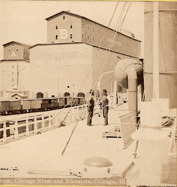
Illinois Central and/or Michigan Central Grain Elevators on the Chicago River
(Satellite, see the 1901 topo map below for better information)
Fifteen of the photos in Evolution of Illinois Central and Grant Park at the Lakefront show at least one of the elevators and have been copied to here.
The IC elevators would be the two elevators in the right background of this photo.
Brendon Baillod posted two images with comments about the ships.
Brendon Baillod shared
Dennis DeBruler shared to RAILROAD HISTORY BUFFS OF ILLINOIS, but I can't get the link
Dennis DeBruler shared to Chicago Area Railroad Historians, but I can't get the link
Dennis DeBruler shared
 |
| 1 |
 |
| 2 |
Dennis DeBruler made four comments on his shares:
 |
| 1 This Sanborn Map index of grain elevators in 1901 shows how a ship could be docked south of elevators 7 & 8. Sanborn fire insurance map provided courtesy of the Map Library at the University of Illinois at Urbana-Champaign. |
 |
| 2 This is a Sanborn Map for elevators 7 & 8. Sanborn fire insurance map provided courtesy of the Map Library at the University of Illinois at Urbana-Champaign. |
 | |
|
 |
| 3 This is a Sanborn Map for elevators 7 & 8. Sanborn fire insurance map provided courtesy of the Map Library at the University of Illinois at Urbana-Champaign. |
 |
| Digitally Zoomed |
 |
| 4 Actually, it looks like the ship was parked in a slip off the Chicago River. 1901 Chicago Quadrangle @ 1:62,500 |
 |
| History's Mirror posted [The only info in the AI-generated platitudes is that this is in the 1880s from the Rush Street Bridge.] Lloyd Scott Hardin shared Dennis DeBruler: Since those two grain elevators were in the Illinois Central Railyard, we are look East towards the mouth of the river. |
 |
| Brendon Baillod posted This interesting, early woodcut engraving arrived today. It appeared in the July 1877 edition of Frank Leslie's Popular Monthly Magazine as part of an article titled "The Great Grain Movement," which detailed the booming grain industry in the US. The woodcut depicts the new elevators constructed in the outer harbor after the fire of 1871. The details are quite accurate, suggesting that the woodcut was created based on an original photograph. An excellent depiction of a big three-masted grain carrier appears as well as early passenger and package freight steamer and a harbor tug. This woodcut is quite large and very finely detailed. Feel free to click on the images and zoom for details. You can read the full article in low res at: https://books.google.com/books?id=iXUqAAAAMAAJ&pg=PA93 Brendon Baillod sharedDennis DeBruler shared An image from 1875. This is looking south along Slip B between Illinois Central's two grain elevators along the Chicago River. The Interstate Exposition Building is in the background just to the right of the center line. Black smoke was still considered a sign of prosperity, so the artist generously added smoke. I've read that grain was one of three commodities that made Chicago and the railroads. (The other two were lumber and meat.) What struck me was the transition from sails to steam. First of all, the steam-powered ship still has a mast. Secondly, both tugboats are steam powered. Tugboats were to water transport as switchers were to railroads --- they handled the on-demand local movements. Just as the transition from steam to diesel started with the switchers, I see that the transition from sail to steam started with the tugboats. |
I added Michigan Central to the title and labels because of this post.
Brendon Baillod posted four images with the comment:
This sharp, early stereoview card arrived today. It is a pre-fire Chicago view made by the notable Chicago stereoview maker John Carbutt.
The view is stated to show Buckingham's Elevator A, which was destroyed in the Chicago fire. It was later rebuilt as the Central Elevator. Based on the maker, the style of card and the the elevator shown, I'd date it about 1869. Another original copy of this card is known to exist at the New York Public Library collection.[The description goes on to discuss the freighter.]
Brendon Baillod shared
 |
| 1 |
 |
| 2 |
 |
| 3 |
 |
| 4 |
Six of the photos in IC Freight Houses Along Michigan Avenue show at least one of the grain elevators and they have been copied to here.
 |
| 1 Paul Petraitis posted |
 |
| 2 Paul Petraitis posted |
 |
| 3 Paul Petraitis posted Our original river/rail connection, 1858, probably a Hesler photo. Paul Petraitis Original in the Chicago History Museum collections, a gift of Mrs. Lizzie Moulton Kneeland. Richard Fiedler shared Rick Powell The Buckingham family owned many of the grain elevators at the north end of the IC tracks. Namesake of the fountain and also the tiny town in Kankakee County. |
 |
| 4 David Daruszka commented on Richard's share Image of the IC holdings in the lakefront and river. There was quite a panoply of railroads using IC's first Central Station (#2 in the image). The CB&Q had their first office building next to the station. |
 |
| 5 Thomas Manz commented on Richard's share What was the last business or industry north of Randolph Street to have a rail connection? Bob Hendricks posted April 10, 1937 – Fire breaks out at 4:00 a.m. at the South Shore depot that sits alongside the Illinois Central Railroad station just east of Randolph Street. It doesn’t take long before “flames burst through the roof of the structure, lighting up Michigan avenue in the vicinity of the public library, and attracting hundreds of motorists and loopgoers to the scene.” [Chicago Daily Tribune, April 11, 1937] The fire brings a large response from the Chicago Fire Department as fire fighters keep their distance battling the 2-11 fire while crowds on the Randolph Street viaduct watch the heroics. The twelve-year-old structure was first used by the Illinois Central but was turned over to the South Shore in 1931. This'll be the second time a fire guts the depot. In a May, 1934 fire, five fire fighters were injured. In the above photo the station stands just to the right of the peristyle, which was torn down in February, 1953. Today this is the northwest corner of Millennium Park. |
 |
| 6 Glen Miller posted 1906 postcard of the Illinois Central's yard. The Michigan Central Railroad, a subsidiary of the New York Central, shared track rights with the Illinois Central. The Michigan Central also shared the IC's Central Station in Chicago as well. A switcher locomotive sneaking behind the freight cars, lower right. Glen Miller Vintage Railroad Postcards David M Laz also posted David Daruszka commented on a posting Markham Yard in Harvey wasn't built until 1926. There were yards at Wildwood, Fordham and the main yards on the lakefront. Here's a postcard image of downtown. Jim Arvites posted Postcard view of the Illinois Central yard in downtown Chicago at Pleasure Craft Harbor and Randolph Street circa 1905. Note the Michigan Central passenger cars. The Michigan Central, a New York Central subsidary, used the IC's Central Station for its Chicago - Detroit passenger service until the late 1950's. David DaruszkaDavid and 3 others manage the membership, moderators, settings, and posts for Chicago Railroad Historians. Other railroads that used the station prior to 1871 were the Chicago & Alton Railroad, the Baltimore and Ohio Railroad, The Galena & Chicago Union and the Cleveland, Cincinnati, Chicago & St. Louis Railway from 1886 to 1893. At one time, and for years, through passenger trains were run between Chicago and Dubuque, Iowa. These trains ran between Chicago and Freeport, Il over the Galena & Chicago Union, and between Freeport and Dubuque over the Illinois Central. Two separate trains ran out of both Great Central Station and G&CU’s Kinzie Street Station. The two trains were combined at Oak Park as one train. On the return the train was split and each section ran to the respective stations. |
 |
| safe_image for Mystery frames river paintings now at Chicago Maritime Museum |
Fifteen of the photos in Evolution of Illinois Central and Grant Park at the Lakefront show at least one of the elevators and have been copied to here.
 |
| 1 |
 |
| 2 |
 |
| 3 |
 |
| 4 |
 |
| 5 |
 |
| 6 |
 |
| 7 |
 |
| 8 |
 |
| 9 |
 |
| 10 |
 |
| 11 |
 |
| 12 |
 |
| 13 |
 |
| 14 |
 |
| 15 |
The IC elevators would be the two elevators in the right background of this photo.
 |
| Glen Miller posted Wolf Point in 1885 Raymond Kunst shared a post Neil Gale My article https://drloihjournal.blogspot.com/.../wolf-point... ChicagoLoopBridges posted |
 |
| Dennis DeBruler shared a Brendon Baillod post via Dennis DeBruler |
 |
| 17:21 video @ 0:18 They original were built from 1855-56. the bigger ones in most of the photos in these notes were built after the 1871 fire. |
Christie Pasieka posted three images with the comment:
I have been sorting stereoscopic photos. I found a mix of Illinois. Finding photos like these give us all a look back to the rush to build and grow. In reading you learn of the number of boats and cargo that came into Peru, but photos are lacking. The ones here does give us the boat designs along with a rush of boats and men in a hurry. Below is the mouth of the Chicago River from Rush St, the photos had several dates, the earliest was 1865.The second photo is year 1895, at the grain elevators in Chicago. The boat is the great whaleback ship(A whaleback was a type of cargo steamship of unusual design, with a hull that continuously curved above the waterline from vertical to horizontal. When fully loaded, only the rounded portion of the hull (the "whaleback" proper) could be seen above the waterline. With sides curved in towards the ends, it had a spoon bow and a very convex upper deck. It was formerly used on the Great Lakes of Canada and the United States, notably for carrying grain or ore.
 |
| 1 |
 |
| 2 |
 |
| 3 |
Subscribe to:
Posts (Atom)