Showing posts with label bridgeRolling. Show all posts

Thursday, July 24, 2025

Amtrak/NYNH&H and Road Bridges over Hutchinson River in Bronx, New York, NY

1908 RR: (Archived Bridge Hunter; Bridge Hunter; Historic Bridges; HAERSatellite)
 
The towers carry electric lines because this is on the electrified Northeast Railroad Corridor.
Street View, Jun 2024

Road Bridges


BridgeHunter_1870
This photo is also in HistoricPelham.
The design was bowstring arch truss. [HistoricBridges_1906]


2019 photo by Geoff Hubbs via BridgeHunter_1906

jag9889 photo via BridgeHunter_1906

HistoricBridges_1906
The bridge is 
a Scherzer rolling lift bridge.

Mosely Iron Bridge built the 1870 spans. Historic Bridges offered this bridge as an extant example of a bridge built by Mosely Iron Bridge.
Historic Bridges

Back to the railroad bridge


Street View, Jun2024

Two of the spans are up while the third is down.
1940 photo by George Votova via BridgeHunter_1908
"Built 1908; originally three parallel 2-track lift spans"

Photo from tugster.files via BridgeHunter_1908

HAER NY,31-NEYO,167--30
30. Hutchinson River Bridge. Bronx, Bronx Co., NY. Sec. 4207, MP 15.73. - Northeast Railroad Corridor, Amtrak Route between New Jersey/New York & New York/Connecticut State Lines, New York County, NY

This is the post that motivated these notes.
Amtrak posted
Many of our infrastructure investments are well-known already, and some you’re going to start hearing more about, like the Pelham Bay Bridge Replacement Project. The original bridge was built in 1907 and today serves over 50 Amtrak, commuter, and freight trains per day. Spanning the Hutchinson River in the Bronx (between Co-op City and Pelham Bay Park), the bridge is part of the Hell Gate Line on Amtrak’s Northeast Corridor.  It is well past its useful life and causes delays due to its age and twice-daily openings. 
A new replacement bridge currently in design will improve reliability, increase efficiency, boost speed, reduce delays, and more. We recently held a public information session with the local community to talk about the project in an open forum. Check out our presentation and learn more about the bridge and the project here: http://spr.ly/6189f6nAS
Nathan Green: I'll also mention that NYCDOT/NYSDOT is in the process of replacing the Shore Rd (vehicle) bridge just south of the Amtrak bridge in this photo. It is also from the early 1900s. It is undergoing the environmental review process right now.

Amtrak
The speed limit will be raised from 45mph to 70mph.
The navigation channel will increase from 8' x 67' to 35' x 100'.
There will be 70% fewer bridge openings.

Amtrak

Friday, July 4, 2025

Great Bridge (Battlefield Boulevard) Bridge over Elizabeth River in Chesapeake, VA

(Archived Bridge Hunter; Bridge Hunter; no Historic Bridges; Satellite)

Arun Ragsac, Jul 2022

avirginiashire

Chesapeake Fire Department posted four photos with the comment:
Just how hot is it today [Jun 25, 2025]? 🥵
It’s so hot... the Great Bridge Bridge wouldn’t close!
The Chesapeake Fire Department is currently on scene working alongside Public Works after a heat-related malfunction caused the bridge to remain in the open position. Crews from Fire Station 5 and Fire Boat 4 are flowing water on the bridge to help cool it down.
Please use alternative routes and stay tuned to the City's social media pages for updates on the status of the bridge. 🔥🌉🚒
Gabi DaCafe shared with the comment: "Overheated bridge won't completely close."
[There are some comments about better ways to spray the water to cool the bridge.]
1

2

3

4

It is obvious that it is a rolling bridge, but it doesn't have the rack and pinion structure that is normally used to move a bridge of this design.
Thomas Jenkins, Oct 2023

This view confirms my theory that they use hydraulic rams to move the bridge.
J C, May 2025

Sunday, June 22, 2025

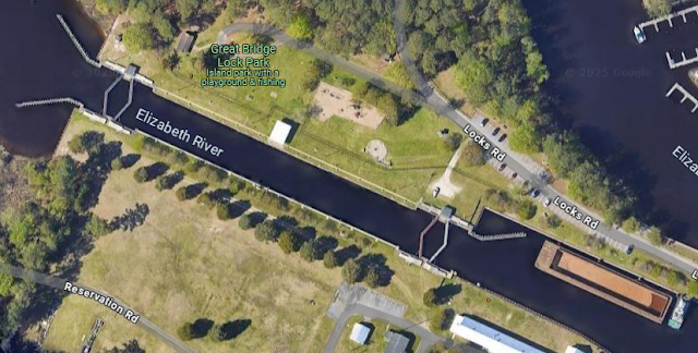
1859 Cheasapeak and Albermarle Canal (Intercoastal Waterway) and Great Bridge Lock & C&A/NS Bridge

Virginia Cut: (Satellite, between Elizabeth and North Landing Rivers.)
North Caroline Cut: (Satellite, between Coinjock Bay and North River.)
Lock: (Satellite)
Bridge: (Satellite)

The lock is more of a guard lock; that is, it doesn't have a lot of lift. The boat on the right is in the lock. On the right side of this view, we get a glimpse of a boat in the lock.
Street View, Aug 2023

carolana

The lock is "a reversible guard lock with double gates at each end of a 220-foot long chamber....The guard lock, reconditioned in 1973 and floored, is unique since it handles alternate heads of water from west and east in the tidal Elizabeth River and fresh water from the North Landing River." [carolana]
Satellite

1902/23 Norfolk Quad @ 125,000

The 75 mile canal had to cut through just 14 miles of land. "The Virginia cut was 8.45 miles long, and the North Carolina cut was 5.6 miles long....The United States government acquired the Albemarle & Chesapeake Canal in 1912 and improved it, first eliminating the guard lock, then in 1932 replacing it with the present six hundred (600) foot steel and concrete guard lock. The channel was dredged and maintained for a twelve (12) foot draft. Covering a distance of almost two hundred (200) miles from Norfolk, VA to Beaufort, NC, the waterway varies in bottom width from ninety (90) feet in land cuts to three hundred (300) feet in open waters. Between 1970 and 1979, commerce on the Albemarle & Chesapeake Canal portion of the Intracoastal Waterway averaged roughly 1.4 million tons annually." [carolana]

The bridge was built by the original Norfolk Southern, not today's NS. The bridge is now owned by the Chesapeake & Albemarie Railroad.

1 of 6 photos posted by Tom Blair, cropped
Took the skiff out for a bit today.  Went out in the Chesapeake and Albemarle Canal (Intercoastal Waterway).  This is the NS drawbridge over the canal, still used today by the Chesapeake and Albemarle Railroad

Some of the views do show it is used by commercial traffic. For example:
Street View, May 2018

A train must be close to the bridge because the bridge is not in the raised position.
Street View, Mar 2023

Tuesday, November 19, 2024

Old Guard Gate and Lost Bridges #7 and #9 on Welland Canal

Guard Gate and Bridge #9: (Satellite)
Bridge #7: (Satellite)

Michel Gosselin posted three photos with the comment: "The old guard gate above lock 7 in Thorold on September 15, 2024."
1

2

3

Derrick Thornbury commented on Photo 1
Here's a photo of it I took in May 2005 from the paper mill...

Michel Gosselin commented on the above post
It was used to regulate water levels and could be closed if a ship took out the lower gates of lock 7, thereby stopping a flood of the lower part of the canal and surrounding areas. They didn’t need this because they put a guard gate at lock 7.

I think these secant gates are the current guard gates. I noticed them when I wasl looking for the former location of Bridge #7.
Satellite
.

Bridge #9


This shows Bridge #9 operating. The road across the gates and the bridge was replaced by the Thorold Tunnel.
brocku, cropped

JD Holmes commented on the above post
Found this one online.
Rick Plato: JD Holmes that pic shows it back when it was the road connecting N.F. to Thorold, prior to the tunnel.
.

Bridge #7


Historical Niagara posted four images with the comment: "Many take the Thorold Tunnel daily but before the 1960s  you had to take a Bridge to cross the Canal Bridge #7 THE PETER STREET BRIDGE was replaced by the Tunnel along with Bridge #9 at the Paper Mill..This was a Bascule style and was used a lot on the Canal ..a few still remain .."
Peter D. A. Warwick: Bascule bridge are actually the most common type of bridge on the present canal. Originally there were 9 such bridges, if you count the ones at Homer as being a double bascule. If you look under the bridge you'll see that they are the same design as the others only instead of having the deck at the bottom they have it on top making them also a draw bridge. Today there are 8. The two newest raised bridges on the canal are bascule: Carlton Street in St. Catharines built about 1968 to replace an earlier bridge that was damaged by a boat hitting it and Mellanby Avenue in Port Colborne, which I don't know when it was built. My guess would be the 1980s or 1990s. There were originally 10. Today only 3 remain. There were originally 2 swing bridges. Today none remain.
1

2

3

4

Monday, August 5, 2024

1889 Carroll and 1905 3rd Street Bridges over Gowanus Canal in Brooklyn, NYC, NY

Carrol: (Archived Bridge Hunter; Historic BridgesSatellite)

A 19:24 video about the canal

Carrol Street Bridge


River View, North elevation, Feb 2015

River View, South elevation, Feb 2015

The building on the left was built between Sep 2014 and Oct 2016.
Street View, Oct 2016

Fortunately, the current satellite image caught the span in an open position and taught me that this is a very rare moveable span. In fact, it "is one of two retractile bridges left in New York, and one of four left in the United States." [BridgeHunter_carrol]
Satellite

I fired up Google Earth to find what it looks like when it is in the closed position. The west part of the span rides on rails on a platform built into, and alongside, the river. The east part is cantilevered over the channel.
Google Earth, Jun 2017

Here is a view that catches it partially open.
Google Earth, Nov 2016

Update: Today's (Nov 6, 2024) satellite image not only shows it open, but also shows some river traffic.
Satellite

United States beauty posted two photos with the comment:
The Carroll Street Bridge, located in Brooklyn, New York, spans the Gowanus Canal and connects the neighborhoods of Carroll Gardens and Gowanus. Built in 1889, it is one of only four retractable bridges in the United States and is one of the oldest of its kind still in operation. The bridge is distinctive for its wooden-planked roadway and its manually operated mechanism, which allows it to retract horizontally along rails to let boats pass through the canal.
Constructed with a simple yet innovative design, the bridge features steel trusses and a deck that slides back rather than lifting or swinging open. When a boat approaches, a small team can operate the bridge by hand, rolling it away from the canal to create a navigable space. Its narrow width accommodates just a single lane of traffic, with an adjacent pathway for pedestrians.
The bridge has survived multiple renovations and repairs, maintaining much of its original character and charm. Today, it is an important historical structure and a reminder of Brooklyn’s industrial past, drawing both locals and visitors interested in its unique engineering and historical significance.
1

2

A 1:05 video of the bridge opening. A 2:44 video of the bridge closing starting at about 1:25
.

Third Street Bridge


Anthony Giudice, Oct 2021
 
This bridge is obviously a bascule bridge. But I was uncertain if it was a trunnion or a rolling bridge. HistoricBridges calls it a rolling bridge. In fact, it is one of the oldest rolling bridges in the country. I wonder what the cables hanging from the bridge are for.
Digitally zoomed
 
HistoricBridges, cropped
"Several Scherzer Rolling Lift Bridge Company bridges were built over this canal and featured in a company catalog. This is one of the photos from the catalog. It is not known which one of the bridges is shown here."
 
1 of 3 photos of this bridge posted by Craig Schofield


Both Bridges


2 of the 3 photos posted by Jammie L Andujar with the comment: "Carroll Street, Third Street Bridges over the Gowanus Canal and Marine Parkway-Gil Hodges Memorial Bridge over the Rockaway Inlet."
1
[This photo shows the cables that pull the span back and forth on the rails.]

2