Showing posts with label wwDPR. Show all posts

Friday, April 28, 2023

Apr 27, 2023: Opening of Houbolt Road Bridge over Des Plaines river in Joliet, IL

(Satellite)

The bridge opened Apr 27, 2023, but the widening of the existing road between US-6 and I-80 is expected to take a few more months. And they expect some truck stops to be built along that road.

fhwa, Source: Credit to I-80 Coalition

CenterPoint is building this toll ridge to help relieve the traffic jams that were created when intermodal terminals and warehouses were built south of Joliet. I've learned to avoid I-80 in Joliet and IL-53 south of Joliet.
map via wjol

hre

hre-about
"The Houbolt Road Extension leverages the industry’s growth and invests in the community’s quality of life. This added route provides a more direct path for trucks to access I-80, taking traffic off local roads like Route 53 and giving them back to the families and our neighbors who use them every day."
[They should have given the local roads back to the residents a long time ago. And I'm sure the truck drivers will be more inclined to serve the area if they don't have to set in traffic jams for long periods of time.]
 
1:19 video @ 0:57
"Houbolt Road Extension – Girder Raising – July 2022"

Note that much of the "land" that we see in the river in the above video was removed when the bridge was done.
ChicagoBusiness
The $170m project was privately funded. It is the first privately built toll road in Illinois.

This is an excellent example of a modern video style that I don't like --- a bunch of closeups that are so close it is hard to figure out what is happening. For example, I guess this chute is at the end of a conveyor belt rather than a part of a ready-mix truck.
0:53 video @ 0:11

Ozinga posted seven photos with the comment: "In honor of Houbolt Bridge opening today, let’s take a trip down memory lane! Thank goodness for this bridge or we’d have to barge your car across the river like we did with our trucks."
1

2

3

4

5

6

7

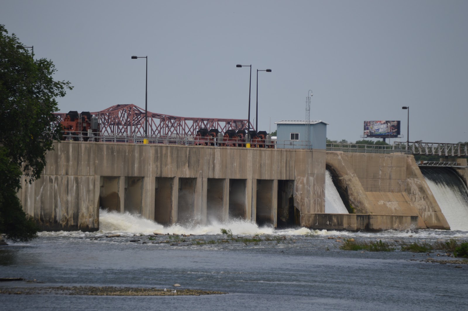
On one of my trips to Brandon Road Lock and Dam, in order to avoid the I-80 jam, I got of I-355 at US-6, took that West to Briggs Street, then South to Mills Road, then West to IL-53. And there I sat through several traffic-light cycles trying to go North on IL-53 to Patterson Road. Now I take US-6 thorough Joliet to Brandon Road. The stop-and-go traffic in Joliet is better than the stop-and-stop traffic around the intermodal yards.

Sunday, April 9, 2023

Brandon Road Lock and Dam and Invasive Carp Barrier

(Satellite)

(Even though this L&D is on the Des Plaines River, I added the "wwIll" label to help me access all of the USACE L&Ds in Illinois.)

Repairs has more information concerning the lock and Invasive Species has more information about preventing fish migration between the Great Lakes and Mississippi watersheds.

USACE
 
USACE, Rock Island District posted
It's time for another #FlashbackFriday and today we head over to Brandon Road Lock and Dam near Joliet, Illinois, on the Illinois Waterway! This photo, taken in 1931, shows construction of the lock chamber. 
Fun fact: Recognizing its historical significance, the Brandon Road Lock and Dam Historic District was added to the National Register of Historic Places on March 10, 2004.

16:05 video @ 2:35

KleinschmidtGroup 2009 Hydro Study

I had no idea the Mississippi comes this far north. It is owned by the USACE, and I understand that it is more of a cruise ship than a towboat.

WaterWaysJournal, Sep 9, 2022
In 2022, slots were added so that stop logs like this one can be used to dewater the lock. The "poiree dam system" had been condemned in the 1990s.

MarineLink, USACE Rock Island District
The replacement of the 90-year old miter gates machinery in 2023 by Brennan will cost $23,484,700.
[Brennan also did the 2022 work.]

The lower gate closing after an upstream tow has entered the lock. 
20150523 1875

Whenever I go to Joliet to railfan, I also try to check out Brandon Lock and Dam. It makes sense to take photos of a dam multiple times because the flows change. In fact, I sometimes make a special effort to go to Joliet after we have had heavy rains to catch how the flow changes.

20170621 9311, cropped
[The truss work in the background on the left side is the I-80 bridge over the Des Plaines River.]

Satellite
Looking at a satellite image, we see that Brandon Road has a bridge downstream of the dam.

Thanks to watching fisherman park on the shoulder of the road and walk out on the shoulder of the bridge, I do the same. The above photo of the dam was taken from this bridge.


20150418

0322

20150523

1806

20150702


2260


Cindy Bender posted
The $1.15 billion Brandon Road Lock & Dam was authorized by Congress in 2020
"Michigan and Illinois officials had reached an agreement in 2024 with the Army Corps to move forward on construction of the project at Brandon Road."
"The project has been held up for months while under review by the Trump administration since December."
"That appeared to change Thursday when the U.S. Army Corps of Engineers announced that the next phase of construction would soon begin on the project known as the the Brandon Road Interbasin Project."
The Civil Works plan released by the Army Corps on April 3 included $28 million to start the contract for the flushing lock and right descending bank's construction.
Assistant Secretary of the Army for Civil Works Adam Telle said in a Thursday statement that he was directing management and execution of the Brandon Road project to be "immediately" transferred from the Corps' Rock Island District in Illinois to the Detroit District in Michigan.
"This transfer will ensure the project progresses in closer coordination with the state of Michigan, which has been a model non-federal sponsor for this project to date," the Corps said in statement by headquarters in Washington."
"Michigan and Illinois officials had reached an agreement in 2024 with the Army Corps to move forward on construction of the project at Brandon Road."
That agreement allows for $274 million in federal funding and $114 million in state funding to be used for the construction of the first of three phases of the project."
Plans involve building a series of mechanisms to block carp from traveling from the Mississippi River watershed to Lake Michigan, including an electric barrier; underwater sounds and an air bubble "curtain" that deters fish; a barge clearing device that makes sure fish don't sneak through; pesticides; upstream fishing; and other methods.
It is expected to take six to eight years to complete.

Sunday, July 24, 2022

I&M Canal: Dam and Lock #5 near Jackson Street in Joliet, IL

(Satellite, the Illinois Waterway Project downed the area of this lock)

I've read about dams and locks in Joliet before, but I can't find that info now. So I'm starting some notes to at least save some MWRD photos.

A new Lock #5 was built when the Brandon Lock & Dam was built.

Please read Joe's comment on his Flickr photo. He explains the location and purpose of this lock and dam. See Locks #6&#7 for an extant example of how a dam's reservoir was used to avoid an aqueduct for a canal.

MWRD posted
A wheelbarrow brigade moving gravel for concrete for a new lock at Jackson Street in Joliet, Illinois, on March 24, 1899.
Frank Stokes: It looks like the lock is still there. Would this be the original spot the I&M connected to the Des Plaines river?

Dennis DeBruler commented on Frank's comment
Frank Stokes The canal connection still exists north of Ruby Street.
41°32'20.7"N 88°04'56.5"W
This lock went around a mill dam, and it was on the west side of the river. The truss bridge in the background of the photo is probably Ruby Street. In the left background and behind the riverfront industries we see the Illinois Iron Works. The building of the Brandon Road Lock & Dam would have put any remnants of this lock under water.

MWRD posted on June 13, 2022
Workers moving gravel for concrete at the construction site of new Lock No. 5 at Jackson Street in Joliet, Illinois, on March 24, 1899.
MWRD posted

MWRD posted
A view to the north showing construction work on the I&M Canal Lock No. 5 in Joliet, Illinois, on March 24, 1899.
MWRD posted
 
MWRD posted on Apr 15, 2023
Construction of Lock No. 5 at Jackson Street in Joliet, Illinois, on March 24, 1899. Construction of the canal was the largest earth-moving operation undertaken on the North American continent up to that time and was notable for training a generation of engineers, several of whom later worked on the Panama Canal. 
 
MWRD posted
Construction of a new Lock No. 5 on March 24, 1899, at Jackson Street in Joliet, Illinois.

MWRD posted on Nov 29, 2021
A barge passes through a newly built lock at Jackson Street in Joliet, Illinois, downstream from the soon-to-open Chicago Sanitary and Ship Canal in 1899.
MWRD posted on Mar 27, 2023
A barge passes through a newly built lock at Jackson Street in Joliet, Illinois, downstream from the soon-to-open Chicago Sanitary and Ship Canal in 1899. Construction of the canal was the largest earth-moving operation undertaken on the North American continent up to that time and was notable for training a generation of engineers, several of whom later worked on the Panama Canal.

I presume the black line on an angle across the river was Dam 1.
925 Joliet Quad @ 62,500


Wednesday, May 11, 2022

Joliet's Movable Bridges Overview

To summarize the following video information, from north to south:
This 0:48 timelapse video of a tow going downbound on the Des Plaines River through Joliet, IL, has motivated me to index my notes concerning the Joliet movable bridges.

0:48 video @ 0:04

I zoomed in so that you can see the leaves of a bascule bridge in the background. These caught my eye because you can watch them go up just before this timestamp. That means another tow is also on the river in Joliet.
Digitally Zoomed

We soon see that the other tow is a local going upbound.
0:48 video @ 0:16, cropped

And that the bridge we saw in the raised position at 0:04 was the Ruby Street Bridge.
0:48 video @ 0:25, cropped

The Jackson Street Bridge is up, but the Cass Street Bridge is still down. On the port riverbank is the Joliet Marine & Drydock and Alexander McKenzie.
0:48 video @ 0:27, cropped

The Cass Street Bridge is almost in its fully open position.
0:48 video @ 0:31, cropped

I added this closeup of the Cass Street Bridge because it shows that the Jefferson Street Bridge is down. That is significant because it had been in its raised position for a couple of years waiting on a part to be fabricated so that it could be fixed.
0:48 video @ 0:34, cropped

For variety, I show the Jefferson Street Bridge on its way up.
0:48 video @ 0:34, cropped

The (Metra+CSX+IAIS)/Rock Island Bridge (#407) is always up unless a train needs to cross it.
0:48 video @ 0:37, cropped

I saved the McDonough Street Bridge as it just started to go up because I wanted to catch the Prairie Creek Grain barge loading facility on the starboard side. The white dome is part of a cement distribution company that is on the other side of McDonough Street.
0:48 video @ 0:41, cropped

Another overview:
1 of 2 photos posted by Dale Bulthuis Jr.
Beau Blessey coming down through Joliet
[Taken from the Cass Street Bridge, we see the Jackson and Ruby Street Bridges. The white bridge in the distance is the BNSF/Santa Fe Bridge over the I&M Canal.]

Facebook Reel

1:21 timelapse video, southbound

1:28 timelapse video, northbound in the dark   Near the end there is a southbound BNSF/Santa Fe train on the I&M Canal bridge and a southbound tow that appears to be waiting for him to come north.

Timelapse downbound Facebook Reel