Sunday, March 31, 2019

Trail/BNSF/GN 1914 Bridge over Yellowstone River near Fairview, MT

(Bridge Hunter, Bridge; Bridge Hunter, Tunnel; no Historic Bridges; 3D Satellite, 154+ photos)
This HAER record is for the nearby Snowden Bridge. I include it because these two bridges have a similar design and the HAER includes several interior shots of the lift machinery.

Unfortunately, this flooded river soon joins the Missouri River so this flood will help prolong the flooding of the Missouri River. Because of the proximity of this bridge to the Missouri River, I have added the "wwMou" label.
Robert Kjelland shared
Chris Marcie Cottrell Why would there be an enormous lift bridge? The Yellowstone is not a navigable river. That looks more like the Missouri downstream of Gavin’s Point dam.
Robert Kjelland Chris Marcie Cottrell when this bridge was built the Yellowstone was classified as a navigable river that not long before saw paddle wheelers, including one that returned Custer’s horse from the Little Bighorn to Bismarck. The Soo Line was forced to put a swing bridge over the Red River between North Dakota and Minnesota for the same reason. It too was never used.

Chalk-a-Lot Dreams & Things posted
Please pray for the Fairview area folks being flooded by the river!
Sheila Eggum Fink Holy Crap!!! I know that river floods, but I haven’’t seen it like that!
[There are more comments about this being the worse they have seen.]

A view of the bridge with a more typical river level.
Flickr Photo by The Goat, License: Creative Commons Attribution-NonCommercial-ShareAlike (CC BY-NC-SA)
This photo shows the different high water marks on the pier. The current flood level is near the top of the ice-breaking slope. That makes it higher than any of the previous watermarks on the pier.

Street View

Note the bluff at the other end of the bridge. That is where the tunnel is.
Richard DeBrunner, Apr 2017
Ethan Akerly, Apr 2017
The tunnel has a curve.
Satellite

Flickr Photo by The Goat, License: Creative Commons Attribution-NonCommercial-ShareAlike (CC BY-NC-SA)

safe_image for The Fairview Lift Bridge
A railroad lift bridge that was only lifted once and became obsolete before construction was finished.
[The article has several more photos.]
Ken Heitzenrater: Fascinating that steamboats were able to travel as far north as Montana.
Eddie Adams: It's fate is simular to the turn bridge at Pierre SD that never seen river traffic.

Saturday, March 30, 2019

Mississippi Lock and Dam #1 at Minneapolis, MN

(John A. Weeks III; Satellite, 44+ photos)

John A. Weeks III
The photo above is a view from the scenic overlook on the East River Parkway. During much of the year, the dam remains dry, and the river current passes through the power house. A small gate next to the power house maintains the pool level behind the dam just below the level of the top of the main dam structure.

John lives in the area, so his page has many photos of the dam from various angles and river levels. This is a small sampling of his photos and commentary.
John A. Weeks III
The dam structure has a inflatable section at the top that can be used to adjust the pool level. The inflatable section on the right side of the dam is a little lower, allowing more water to flow over that side of the dam. The concrete blocks at the base of the dam are called ‘grinders.’ They calm the flow of water at the base of the dam.
John A. Weeks III
John A. Weeks III
This photo is looking down from the pedestrian walkway towards the bottom gate on the western lock as it opens to allow boats to exit from the lock heading downstream. 

Flood of 2019:
[Fast forward to about 5:00 where he does a 360-degree pan of the GN Stone Arch Bridge.]
https://www.facebook.com/CBSMinnesota/videos/463181487555665/
Patty Reese Curtin2:29 50 plus inches of snow melted all in 2 weeks!! I feel for all the flooding south of the rivers! Lord Have Mercy, Amen
Joyce Scalze9:26 Now go over to downtown St. Paul and see what the river does there. They have closed 4 streets closest to the river that will probably be under water....

Just downstream from the lock
Jordan Palmer posted
The beautiful Stone Arch Bridge over the Mississippi River at Minneapolis from a slightly different angle. Built by James J. Hill for his Great Northern Railroad, the bridge opened in 1883. The bridge carried two tracks and was originally all stone, note the steel span over the channel, this was built in the 1960s to allow river traffic access to the northern end of Minneapolis. In order to minimize effects on rail traffic, the stone footings were widened, and the steel super structure built around the two stone arches. Once the main frames were up, rail traffic was halted the two arches were knocked out, and cross-members and tracks installed on the steel span, rail traffic was only impacted for seven hours. Unfortunately the passenger rail continued to tumble and after 1971 only Amtrak used the bridge to access the Great Northern Depot. On March 1, 1978 the new Midway Depot closer to St. Paul opened and was the last day passenger trains regularly crossed the Stone Arch Bridge. It is now open as a walking and biking path following major rehabilitation in the 1990s. I captured these photos in September 2013 from the top of the Mill City Museum.
Boyd Walker It now needs more repair work.

August 2021:
Mary C Kennedy posted
Well, we are below 3 feet in St. Paul.
[So loaded barges are not making it up to these locks. I wonder how far northbound the tows can make it.]

Friday, March 29, 2019

Manitowoc MLC300 Luffer Crane and Microsoft Server Farm

(Update: I made a second trip and caught them loading boom segments onto truck trailers.)

I've been seeing some postings of a 
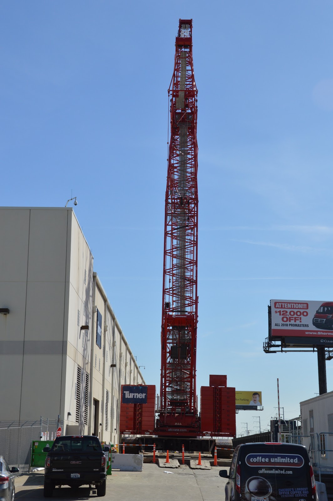
Manitowoc MLC 300 next to I-294. So on the first clear day of this year that wasn't cold and/or windy, March 26, I made a trip up there to check it out. It is working on a Microsoft building. I got there before 3pm, but they had already stopped working for the day. However, the trip was not in vain because I did want to get photos of the crane with a long luffer jib in its parked (jackknifed) position.

In this post, the operator, Frank Bauer, explains: "we start at 95 main and 255 Lyft then go to 95m and 196 l and finish with 95 m and 177 l."

20190328 7454
I started from the side of the building where I could get a clear view because there was a gate in the fencing. Turner is the contractor.


I count ten counterweights on each side for a total weight of 200t. Note the box on top of the right counterweight stack. The toolbox on top of the right counterweight stack "probably holds rigging to put the crane together." [Joseph Hobbs comment on one of my Facebook postings.] Thomas Cassidy The box on top holds the beckets and 2 block weights and stuff like that. Derek Huss That box is a tool box our 300mlc had beckets and some pins in it.


I then walked across Northwest Avenue to get some distance from the crane so that I could get some overview shots. I repeat the photo at the top of these notes to put it in context. I had to move around to find an angle that included the whole crane with my zoom's widest angle of 18mm, to reduce the glare off the boom, and to clear the billboard.


At the other end, I crossed Northwest Avenue again to try to find an overview that was clear of the billboard.


I'm including this "bad" view. Even though the main boom got skunked by the billboard, this angle has a better view of the wheels on the tip that are needed if they want to lower the main boom all the way down to the ground.


A close up of the tip
An even closer view of the tip wheels at camera resolution. I was curious how much detail the camera could capture at ISO 400.
I took a couple angles of the main part of the crane as I walked back. I've learned with truss bridges to take multiple angles because sometimes a truss member will hide something you want to see in a view. And the fence is a hassle.


In this close up, we can see that the hoists are mounted in the base of the boom. This allows the designers of the crane to reduce the weight of the housing so that it is cheaper to transport it over the road. (It is still probably expensive. But it is cheaper than it would be if all of the hoists were still in the house.) We can also see the 300 of the MLC300 label so I know it is not a MLC650.


In this view, I was trying to get most of the hydraulic hoses that power those hoists to show between the fence posts.


With this angle, I'm trying to show the loop in the VPC "chain."


I was going to skip this first closeup photo I took, but now I see that it confirms the purpose of the "chain" is to organize and protect all of the hydraulic hoses that go to the counterweight tray.


It appears they are adding HVAC (Heating, Ventilation, and Air Conditioning) equipment on the roof.


A couple of days after I took my photos, John Schilberg caught it parked at the middle of the building instead of at the north end. One advantage of this job compared to windmill erection is that they are walking the crane on a paved surface rather than on a farmer's field.
John Schilberg posted
Elaine caught it working:
Elaine Peterson posted, cropped
I posted three photos from this blog with the question: "What does the box on top of the right counterweight stack hold?"
Thomas Cassidy The box on top holds the beckets and 2 block weights and stuff like that.
Derek Huss That box is a tool box our 300mlc had beckets and some pins in it
Anthony Carney commented on my post
This is one of the posts that let me know there was some interesting action next to the I-294.
David Hall posted three photos with the comment: "Seen this little fella by rosemont."
John Craig Weir Not Rosemont in Northlake I believe. 294 North Bound.
John Craig Weir Microsoft Data Center when it was originally built.


1

2

3

While driving east on North Avenue, I discovered that a Manitowoc 2250 luffer crane is helping to build a new building between Foxy Nail and a Shell station.


(End of crane photos.)


Most of my notes that have the "engeryElectric" label are concerned with the generation or transmission of electricity. In this case, it is about the consumption of electricity. There are no signs on the building indicating who owns it, but Google Maps labels it Microsoft.

Satellite
I included the transmission switchyard west of the Microsoft building to help illustrate that the building is just south of the significant power transmission corridor shown below. Power is transmitted using three phases, so three wires are needed for one circuit. Using my notes on ComEd voltages, Each tower is carrying two 345kV circuits and the middle and southern towers have an extra cross arm at the bottom to carry a 138kV circuit.
Street View
That corridor is so big that Republic Services built a transfer service under the power lines. There were enough garbage trucks entering and leaving the facility that I had to wait a while to find a gap in the traffic to cross their driveways from where I was parked.
Satellite
At the north end of their building, Microsoft has a switchyard that is larger than what most towns have. And on the east end is probably some backup generators.
Satellite
Since it was quitting time, the bus was waiting
for the crew to board.
There are two 138kV circuits feeding this switchyard This Street View shows that the western circuit is connected to the middle transmission line and the eastern circuit taps the southern transmission line. I'm sure that either circuit can supply the needs of the building. They use two circuits for redundancy.

Note that  east of the building is a railroad. That probably means the building is close to long-distance fiber optics. In fact, there might be fiber optic cables for multiple communication carrier companies using the UP (former C&NW) right-of-way.

The name Microsoft, the proximity to lots of electricity and fiber optics, high security (no signs), and lots of HVAC units on the roof tells me that this building houses a server farm. That is, it is full of computers. Server farms need a lot of electricity to power the many processors that are in the building. But all of that power ends up as heat, so they also need a lot of power for air conditioning to remove all of that heat.

Satellite
Judging from the HVAC units on the southern half of the building, Microsoft planned for growth and they are now finishing the northern half.


Thursday, March 28, 2019

Flood of 2019: IAIS/Rock Island 1900 Quadrangular Trusses near Booneville, IA (Update: bridge replacement)

(Bridge Hunter; no Historic Bridges; John MarvigIAIS Plans (but you need a login to access the info!); Facebook GroupSatellite)

This is a win-win posting. It not only shows the impact of the 2019 flood, it documents a double-lattice truss bridge that is soon going to be replaced. Note in the satellite image that the two eastern spans are normally over land. In these photos, water is under all four spans.

Screenshot
[The river is flowing fast. At least there are no ice slabs on it.]
A street view shows us a more normal river level.
Street View
Chris C J Johnson posted 20 images with the comment: "Built in 1900 for The CRI&P the Booneville, Iowa Bridge over the Raccoon River will be replaced by IAIS in the Summer of 2019.
High Water•3/17/19"
1

2

3

4

5

6

7

8

9

10

11

12

13

14

15

16

17

18
I did not include the last two images because I recognized them as a copy of John Marvig's work.

John Marvig
The bridge is being replaced. Saving the satellite image because the truss has nice shadows and is probably going to disappear.
Satellite

Booneville Rail Bridge 1900-2020 posted videos and photos with the comment: "1900 CRI&P/IAIS Bridge Replacement Update 3/26/20   Booneville, Iowa"
Chris C J Johnson shared
5

6
 The videos show the caisson sheet being turned.
8

16

18

20

22

Chris C J Johnson posted
Truck bringing in one of the 55’+ long rebar inserts for the pier caissons being drilled into the riverbed.

Chris C J Johnson posted
[The various sized augurs surprised me. Do they start with a small hole and then keep increasing the size until they get to the caisson diameter? Or are the caissons of different diameters? Or does the contractor bring all of his equipment to every site?]

I don't know what they are doing here. It is obviously of a smaller diameter. Note the poured caisson with rebar sticking out doesn't have any steel around it. Can they pull the steel shell back out and reuse them? Or did they cut off the top?
Chris C J Johnson posted

The above must be drilling a pilot hole because I think this is in the same location.
Chris C J Johnson posted

Chris C J Johnson posted  (perm)
Chris C J Johnson posted some photos with the comment: "Booneville Bridge 4/11/20."
a

b

c
Chris C J Johnson posted some photos with the comment: "IAIS/CRI&P Bridge Replacement Booneville, Iowa May 9, 2020"
Chris C J Johnson shared
Chris C J Johnson Built in 1900 by the Chicago Rock Island & Pacific Railroad (CRI&P) and now used by The Iowa Interstate Railroad (IAIS).
Located just 1/4 mile West of the small town of Booneville, Iowa this bridge and its four trusses spanning 632 feet cross the Raccoon River.
Progress vs. History.
After 119 years-A new bridge will be built on the Southside of the old bridge and the old bridge will be demolished.
This Facebook group is “Public”
Please feel free to invite your friends to this group and you are welcome to share all postings.
C JMike Brady Any builders plates on it, hate to see all these truss bridges scrapped.
Chris C J Johnson Mike Brady My understanding is that IAIS is replacing and demoing them all...2019 it was the 1800’s era bridge over Walnut Creek in DSM.
C J
a

b
This is the photo that Facebook chose when Brendan J Dock shared the post
[I didn't think American cranes still existed. I associate that brand with cute little railroad cranes.]

c

d

c
[They use just steel-pile bents on the bank as opposed to concrete piers.]

d

Chris C J Johnson commented on the above photo
CRI&P Rivet Coal Fired Rivet Forge.
These rivets were heated and thrown to a leather or asbestos blanket held by the workers putting in the rivets with a steam powered hammer.

e
[He has several more closeups of this 1900 pin-connected truss.]

f
[There are several other photos recording the closeness of the two bridges. Chris commented: "A great challenge to the future demo company of the 1900 bridge being that close I would guess!"]
When I noticed that a pier seemed to be slanted in one of Chris' photos, I looked for it in street view. Srue enough, IAIS had to repair a pier damaged by the 2019 flood.
Street View

One of several photos posted by Chris C J Johnson
The last section is in.  5-23-20
The new railroad bridge was needed as the truss bridge had met the end of its functional use. Two of its piers had tilted due to years of flooding and erosion. Others had cracks and were spalling. The new 661 foot multiple-span bridge will carry train traffic of up to 40 mph- double of that of the railroad bridge)- and trains will be able to carry taller and heavier loads. The $3.5 million project was half funded by the federal government through the Federal Railroad Agency through the use of Consolidated Rail Infrastructure and Safety Improvements (CRISI) grant. It took only 17 months to build the new span. It’s part of the 20+ year project to modernize the entire line and will include additional bridge replacements in the future, including three bridges in Davenport- the 3rd and 4th Street Overpasses and the Arsenal Bridge. [BridgeHuntersChronicles]

They got rid of the old bridge in just three weeks in July, 2020 after the new bridge opened June 30, 2020.