(
Satellite)
"The Hammel Woods Dam was built in the 1930s by Civilian Conservation Corps workers. The 4-foot-high concrete and limestone dam was built to create a pool of water for recreational purposes during a time when the DuPage River had a much lower volume of water than it does now." In the past, some people objected to the removal for sentimental reasons. But now people recognize the river and safety benefits of removing a dam. The final piece of the needed funding came February 2019 from a wastewater discharge permit for the City of Naperville.[
ReconnectWithNature]
I saved a satellite image since it will be changing.
The article said that the DuPage River has five dams. Since I didn't know about this one, I spent some time looking for the other four by starting at the mouth and going upstream.
Was this one of the five?
Then I found this Hammel Woods Dam.
The relatively new
storm retention dam is the other one I knew about. Note that it does not obstruct a normal flow of water in the river. It stops only an excessive flow to reduce the flooding in downtown Naperville..
I wonder what the story is concerning
this stone rubble.
Another dam remnant? I know that Naperville used to have a dam for a mill because that is what founded the town. But I don't know where it was.
I quit looking
at North Avenue because it is not much more than a drainage ditch this far north.
Since I didn't find five existing dams, I did a quick look up the East Branch to the
Hidden Lake Forest Preserve. I didn't find any dams on that stretch.
Update:
 |
People visit the DuPage River dam at the Hammel Woods Forest Preserve in Shorewood last Thursday. (Zbigniew Bzdak/Chicago Tribune)
"In Will County, forest preserve commissioners Thursday approved contracts to remove a dam on the DuPage River where a young couple drowned last year. The dam, located in Hammel Woods Forest Preserve in Shorewood, was constructed in the 1930s by the Civilian Conservation Corps. The project involves removal of the 4-foot-high dam and an adjoining concrete structure, placing rocks and boulders in the river stream, stabilizing the bank and building a new canoe and kayak launch area.
The total cost is estimated at about $455,000. The Lower DuPage River Watershed Coalition, a group of local governments aiming to improve water quality in the area, plans to fund most of the cost from fees paid by Naperville in 2019 when it got a new wastewater discharge permit." |
There is
a NWS hydrologic metering station here.
 |
July 30: 10 photos
How exactly do you safely remove a dam? Well, it's a bit of a process and that's currently playing out at Hammel Woods. Crews have been busy installing a coffer dam around the existing dam. That coffer dam will block off the river and then the area inside will be dewatered to create a dry and safe working environment. This project has resulted in closures near the work area. Get all the details on the closures and this project >>> https://bit.ly/37mRXGR.
[I would think they would fill in the upper dam to stop the flow before they built the lower part.]
Tom Romanowski: I still don't even know why the had built it in the first place.
Brad Brooks: Tom Romanowski when it was built in the ‘30s, the water levels on the river were lower. It was put in to create “pooling” for recreation upstream.
|
 |
Facebook
It's been a bit of a process so far, but the removal of the Hammel Woods dam has begun. After most of the water inside the cofferdam was pumped out, crews started working on removing a portion of the dam this afternoon. Work will continue on Wednesday and once this section of the dam is removed, the entire process will play out again on the other side of the river. It's also worth noting that those massive barriers, fencing and signage pointing out that this section of the preserve is closed is not merely a suggestion. People continue to enter the construction area. The lower section of Hammel Woods is closed for a reason; this is a work area with heavy equipment coming in and out. Why risk getting a ticket to see the activity when we're providing updates like this?
More on this project >>> https://bit.ly/37mRXGR. |
FPDoWC
posted four photos with the comment:
It sure has been a busy week at
Hammel Woods and lots of progress has been made on the dam removal project. Today, you can see that the new kayak launch — which is just south of the dam — is taking shape, with the concrete walkway in place. Crews continue working on the cofferdam installation on the west side of the river around the remaining section of the dam. Once the cofferdam is complete, approximately 100,000 gallons of water inside it will be pumped out to create a dry working environment. Why are we doing this project? Will it affect the river levels? When will the project be done? We have the answers to all your dam questions here >>>
https://bit.ly/3jNVS5g.
 |
| 1 |
 |
| 2 |
 |
| 3 |
 |
| 4 |
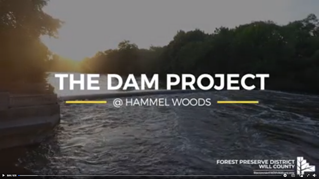 |
Screenshot
The Dam Project at Hammel Woods The dam at Hammel Woods is gone and now that the dust has settled, it's a perfect time to take a look back at this project, which was funded by the Lower DuPage River Watershed Coalition. The dam’s removal will result in a significant positive impact on the health of the river for years to come. |
I'm saving an overview satellite image so that I can tell where it was in the future.
I made a trip on Feb 10, 2023, to get some "after" photos. This photo from
the bridge provides some context. The parking lot is on the left, the cement ribbon is the canoe/kayak access and the inlet on the right is the mouth of the creek. It had rained most of the previous day so the river was running high.
 |
| 20230210 2211c |
In this Oct 2022 view, we can see the canoe access by the river because it is not under water.
While street viewing, I record the water level upstream as well. I did not see any of those rock intrusions when I was there because they were buried under water. The second rock intrusion is about where the dam was.
Starting from the parking lot. The bridge on the left is over the creek that empties into the river.
Quite a bit of the canoe access was under water. The dam was up by the "white line" in the trees.
This is the creek from the bridge. These are four of the ducks I saw. Some were just floating down the river.
I think this is where the dam used to be.
I noticed that the water had some turbulence a little upstream of this location. It would be interesting to see what is in the riverbed when the river level is lower.


.jpg)


