These are notes that I am writing to help me learn our industrial history. They are my best understanding, but that does not mean they are a correct understanding.
(Even though this L&D is on the Des Plaines River, I added the "wwIll" label to help me access all of the USACE L&Ds in Illinois.)
Repairs has more information concerning the lock and Invasive Species has more information about preventing fish migration between the Great Lakes and Mississippi watersheds.
It's time for another #FlashbackFriday and today we head over to Brandon Road Lock and Dam near Joliet, Illinois, on the Illinois Waterway! This photo, taken in 1931, shows construction of the lock chamber.
Fun fact: Recognizing its historical significance, the Brandon Road Lock and Dam Historic District was added to the National Register of Historic Places on March 10, 2004.
WaterWaysJournal, Sep 9, 2022 In 2022, slots were added so that stop logs like this one can be used to dewater the lock. The "poiree dam system" had been condemned in the 1990s.
MarineLink, USACE Rock Island District The replacement of the 90-year old miter gates machinery in 2023 by Brennan will cost $23,484,700. [Brennan also did the 2022 work.]
The lower gate closing after an upstream tow has entered the lock.
20150523 1875
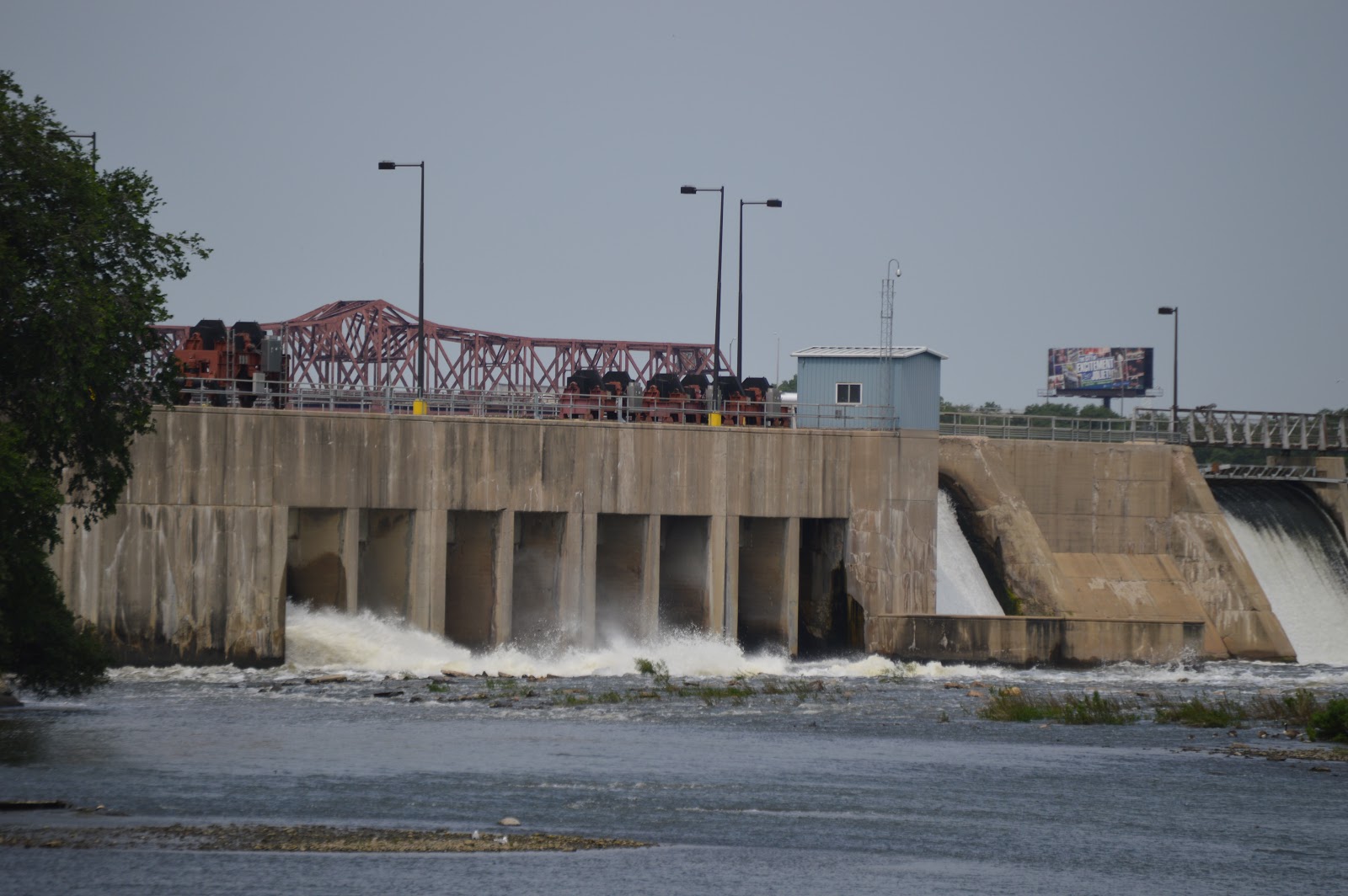
Whenever I go to Joliet to railfan, I also try to check out Brandon Lock and Dam. It makes sense to take photos of a dam multiple times because the flows change. In fact, I sometimes make a special effort to go to Joliet after we have had heavy rains to catch how the flow changes.
Looking at a satellite image, we see that Brandon Road has a bridge downstream of the dam.
Thanks to watching fisherman park on the shoulder of the road and walk out on the shoulder of the bridge, I do the same. The above photo of the dam was taken from this bridge.
When you're locking down ~35 feet like we did at Brandon Road, the outside world starts to disappear as you drop down. Sounds quieten, and the noise of rushing water dominates. For a few minutes, you exist only in this momentary Looper world, walled off by the concrete lock chamber.
And then they crack the lock doors open, and the outside world slowly reappears.
Randy Johnson commented on the above post Unfortunately you do not get to experience the cool waterfall at the lock up river from there if you are headed South. It is quite unique for a lock.
Happily Wherever After: Randy Johnson sounds like we need to turn around, we're going the wrong way!
Lou Jones: You’ll love Jaime Whitten lock. 85’ drop with water squirting out of the walls 😳
The $1.15 billion Brandon Road Lock & Dam was authorized by Congress in 2020
"Michigan and Illinois officials had reached an agreement in 2024 with the Army Corps to move forward on construction of the project at Brandon Road."
"The project has been held up for months while under review by the Trump administration since December."
"That appeared to change Thursday when the U.S. Army Corps of Engineers announced that the next phase of construction would soon begin on the project known as the the Brandon Road Interbasin Project."
The Civil Works plan released by the Army Corps on April 3 included $28 million to start the contract for the flushing lock and right descending bank's construction.
Assistant Secretary of the Army for Civil Works Adam Telle said in a Thursday statement that he was directing management and execution of the Brandon Road project to be "immediately" transferred from the Corps' Rock Island District in Illinois to the Detroit District in Michigan.
"This transfer will ensure the project progresses in closer coordination with the state of Michigan, which has been a model non-federal sponsor for this project to date," the Corps said in statement by headquarters in Washington."
"Michigan and Illinois officials had reached an agreement in 2024 with the Army Corps to move forward on construction of the project at Brandon Road."
That agreement allows for $274 million in federal funding and $114 million in state funding to be used for the construction of the first of three phases of the project."
Plans involve building a series of mechanisms to block carp from traveling from the Mississippi River watershed to Lake Michigan, including an electric barrier; underwater sounds and an air bubble "curtain" that deters fish; a barge clearing device that makes sure fish don't sneak through; pesticides; upstream fishing; and other methods.
It is expected to take six to eight years to complete.
MLive.com posted New stoppage comes four months after Trump officials shifted management of the $1.15 billion project to Michigan and claimed it would move forward aggressively. https://mrf.lu/256Zm "The agency has not answered questions about what prompted the review, who ordered it, what work is affected or how long it may last."
SunTimes "Contractors at the Brandon Road Interbasin Project received a work stoppage order on July 24 stating the project is under administrative review, despite about $2 million worth of material already on site. Work was slated to begin this week [Aug 3, 2026], with shaft drilling scheduled for September. Jobsite trailers were also already set up at the project, according to Will County officials."
I combined the dam and bridge notes because many photos include both.
I start with a satellite image to describe the layout. Understanding the layout makes it easier to place the photos. The big white stripe in the middle of this image is the main spillway with a 40' drop. The V-on-its-side just upstream is an apron the USACE built to cap the rock to stop the erosion of the falls. It is another 10' drop. Minneapolis became a large four mill center because these falls had nearly 50,000 horsepower of energy. [John Weeks L&D] South of the main spillway is the channel for the lock. Below that is a visitor center and the Great Northern Stone Arch Bridge, which has been turned into a trail. Below that we see a remnant of a millrace.
Above the spillway in the overview is a headrace. On the south side of that headrace is the St. Anthony Falls Laboratory that was founded in 1938. The lab uses the 50' drop at the falls to provide water flows for experiments and simulations such as the affect of removing a dam. The green area to the left of the lab would be the outdoor test channel and stream simulation facilities. [John Weeks Lab] The building at the end of the headrace is the powerhouse. It was built in 1908 to supply the streetcar system. Now it feeds 12 MW to the grid using five generators. [John Weeks Power]
USACE "Dam consists of a horseshoe dam with a chord dam downstream of the the horseshoe and a concrete overflow spillway owned by Xcel Energy Center."
"The US Army Corps of Engineers closes the locks to recreational users when the flow hits 30,000 cubic feet per second, and closes to commercial traffic at 40,000 cubic feet per second." [John Weeks L&D]
John Weeks L&D [Of course, the main spillway is across the middle of this photo. The Third Avenue Bridge is behind that. And the 10' drop of of the "V" is visible as white lines under the bridge.]
Bridges Now and Then posted Construction on the 3rd Avenue Bridge, Minneapolis, Minnesota, c. 1917. IMinnPost)
Bridges Now and Then posted Third Avenue Bridge construction, Minneapolis, Minnesota, 1917. (Mill City Times)
An upstream view from the Hennepin Avenue Bridge shows the navigation channel under the right-most arch and the turbulence of the "V" in the middle.
When you have a 50' drop, the gates on the lock are rather big.
John Weeks L&D
nps This dam has a visitor center. "With a lift of 49 feet, the lock at St. Anthony Falls accounts for more than 10% of the total height change of the Mississippi River between the Twin Cities and St. Louis, MO. In 2015, the Upper St. Anthony Falls Lock and Dam closed to river navigation."
If you look at the satellite image you can see the bridge curves. John Weeks and Historic Bridges explain that one reason was to locate the piers on solid rock. They had to avoid building a pier on fractured rock. But another reason is that Third Avenue does not align with Central Avenue. "The Third Avenue Bridge is the longest S-curve shaped concrete arch bridge in the world." [John Weeks Bridge]
John Weeks Bridge
"The photo above was taken late in the evening in the spring of 2005. The low angle light from the sun was able to get in behind the concrete supports and light up the inside of the bridge. The photo below is another image taken during the golden hour just before sunset. Here, we see the bridge bathed in yellowish sunlight while the buildings in the background appear to be in black and white due to being in the shade. This photo won the 2012 Othmar H. Ammann Award for best photo." [John Weeks Bridge]
John Weeks Bridge
Historic Bridges A drawing from the original plans The bridge was rebuilt in 1980. They ended up replacing everything above the arch ribs. The arch ribs use Melan type reinforcement. That means the steel reinforcement is a truss.
In 1939 a new deck was built. It widened the deck to replace two streetcar tracks, two traffic lanes and two pedestrian lanes with four traffic and two pedestrian lanes. [John Marvig]
MPRnews, one of 11 photos in a gallery "Upper St. Anthony lock closing after half a century; blame the [Asian] carp" It closed in 2015. This article has a nice history section.
10:49 video @ 6:32 The Only Waterfall on the Mississippi is Broken In 1876, the USACE completed a cutoff wall to stop the erosion of the waterfall. The waterfall originally, 10s of thousands of years ago, was in St. Paul.
Granite Falls Dam: (Satellite)
Minnesota Falls Dam: (Satellite, Google Earth Images are below from when it still existed)
John A. Weeks III, during 2008 Spring flows
"The Granite Falls Dam was built in the late 1800s to supply mechanical power to a mill. It was abandoned in 1896. The City of Granite Falls bought the dam in 1911 and installed hydro power generators. The hydro plant was recently upgraded with more efficient equipment, resulting in a total electrical output of 1.2-Megawatts. The city hydro plant manager suggests that this is enough energy to supply the needs of 70% of the city."
John A. Weeks III, during 2010 Spring flood
"The river is higher than the water levels in the 2008 photos above, but it has not significantly overflowed its banks."
While trying to find the MW capacity of this dam, I discovered that the Minnesota Dam that was three miles downstream was removed in 2013 to restore the three mile long rapids of the Minnesota Falls. John Weeks indicated in 2008 that Granite Falls wanted to convert it to another hydropower plant. But the need of the fish in the Mississippi River to use this rapids as a spawning ground prevailed. Remember, a couple million watts of generating capacity is a drop in the bucket compared to one 600MW water boiler (coal or gas) unit. And power plants generally have more than one unit.
Fortunately, John got photos of the Minnesota Falls Dam before it was removed in 2013.
John A. Weeks III
"This 1905 era dam is owned by Northern States Power, which is now known as Xcel Energy. The hydro power generator was dismantled in 1961. The dam was used to store cooling water for the nearby Minnesota Valley Generating Plant. That plant closed in 2004, leaving the dam obsolete. Xcel Energy considered rebuilding the dam, but the hydro power potential was too small to be worth rebuilding by a major utility."
The demolition photo below confirms that the upstream side of the dam is just a flat wall. The dam is built on exposed granite bedrock. So they did not have to worry about a "gentle" spillway curve to minimize scouring at the base of the spillway.
I excerpted two "before" images to capture a high Spring flow (April) and a low late-Summer (Sept.) flow.
Google Earth, Apr 2011
Google Earth, Sep 2012
Google Earth, Apr 2015
(new window) They not only removed the dam, they dredged quite a bit of the sediment that had accumulated behind the dam. And it looks like they spent more time doing bank restoration work than it took to remove the dam itself. Since all of the work was done in just two months, I don't understand why they built a rock bank and then removed the rocks to build a dirt bank.
DNR dam inspectors had ordered Excel to repair or remove the 14' tall, 107 year old dam. The estimate for repair was $15m whereas demolition was estimated as $2m. "Between the two dams [Granite Falls and Minnesota Falls] are five areas where the granite is pushed up, which will create a long area of rapids that will be useful for fish and sought out by paddlers." The deep pools in the fragmented granite riverbed creates spawning beds for fish, particularly for sturgeon. The removal of the dam was easy because the mortar was so soft from age. [MankatoFreePress]
After they removed the 1905 Minnesota Falls dam in 2013, the base of an 1871 dam in Granite Falls was exposed. The remnants of that dam was removed in 2015. "Dr. Luther Aadland with the Minnesota DNR, who has built an international reputation for restoring fish habitat when dams are removed from riverine systems, oversaw the restoration. Its goals are to restore the spawning habitat needed by the river's rock stars: Lake sturgeon, paddlefish, walleye, and sauger among them....Aadland has been part of research that is showing that fish naturally migrate long distances in river systems. Radio tags have tracked sturgeon that migrated in the Mississippi River from near the Iowa border to locations in the Minnesota and St. Croix Rivers to find the spawning habitat they need. They returned to the waters near Iowa within two weeks, indicative of how important the right spawning habitat is for this species. There are walleye in the Missouri River system that annually make 200 mile migrations. Aadland said he has little doubt that once discovered, this newly-restored site will attract many fish species for spawning....Since its removal, 12 of the 39 native species that had been blocked have now returned upstream, according to a study published in 2015." [wctrib]
RachelContracting
Xcel Energy selected Rachel Contracting to remove the existing dam and all remaining features that were originally part of their Hydroelectric facility. The work included installing and maintaining erosion control features, clearing and grubbing, designing, installing and maintaining water control measures, demolishing the dam and related structures, removing sediment upstream from the dam, hauling and placing sediment at the MN Valley Power Plant, and performing final grading, seeding, tree planting and restoration of the site. All work was performed in the MN River Basin, consequently the project team had to be aware that significant changes in flow and water level could occur at any given time. Over 2,000 The Rachel Team efficiently executed the work plan and completed the project safely and on schedule.
Design & Install--Water Control & Management Plan to Re-Route Flow of River
Design & Install--Steel Box Bridges for Equipment Crossing
7,000 CY--Sediment Removal
5.5 Acres--Site Restoration
105 Each--New Trees Planted
Dams don't allow the native (desirable) fish upstream. And mussels need fish to help them reproduce. In fact, specific mussels need a specific fish. "When Lock and Dam 19 was built on the Mississippi in Iowa in 1913, migratory skipjack herring disappeared from the watershed upstream of the dam. Previously found upstream to Big Stone Lake on the Minnesota River, skipjack herring are the sole hosts of ebonyshell and elephant ear mussels. The disappearance of these two mussel species followed suit. Ebonyshell had been the dominant mussel of the upper Mississippi and lower Minnesota rivers. Half of the roughly 40 species of native mussels that once existed in the Minnesota River can no longer be found." But carp love the feted waters of dam reservoirs. Ironically, two dams built as carp barriers didn't stop nonnative carp but did stop "desirable native species unable to tolerate low oxygen levels and pollution." I wonder if these carp-barrier dams were built to stop the Asian Carp. Or if they were fighting an earlier carp invasion. "Projects that reconnect river systems are bringing back native fish and mussel communities across the state. Approximately two-thirds of the fish species that were absent upstream have returned after dams were removed or converted into rapids. Lake sturgeon have been reintroduced to several watersheds, and 5-foot-long fish are being caught where the species hadn't existed for generations. To bring back some species, we will also need to work on restoration of degraded rivers, riparian buffers, downstream barrier removal, wetland restoration, water quality improvements, or reintroduction." [dnr.state.mn.us]
Our “stop the beast″ strategy of relying on dams and other barriers to block Asian carp has two very big drawbacks. It doesn’t work, and it causes more harm than good, according to a river ecologist and researcher....Dams are one of the factors responsible for what some are calling the sixth mass extinction in the earth’s history. The extinction rate for freshwater species is five times that of the extinction rate for creatures on land....As for stopping Asian carp, there are 22 other ways that Asian carp can reach new waters besides upstream migration. On the Minnesota River, they will readily get by the dams now in place, he pointed out....The Granite Falls dam on the Minnesota River is 21-feet high, but during flood conditions there is only a five-foot elevation difference. Asian carp easily jump 10-feet high to reach new waters.... The Minnesota River now runs free for 257 miles from Granite Falls to the Mississippi River, leading some to argue for at least a fish passage at the Granite Falls dam. Del Wehrspann, a founder of CURE and river advocate, noted that the City of Granite Falls is in the process of replacing two small hydro-electric turbines in the municipal dam without so much as discussing the need for a fish passage. “With all we know...,″ he said, “Why isn’t this even considered.″ [GraniteFallsNews]


 Thanks to watching fisherman park on the shoulder of the road and walk out on the shoulder of the bridge, I do the same. The above photo of the dam was taken from this bridge.


 Thanks to watching fisherman park on the shoulder of the road and walk out on the shoulder of the bridge, I do the same. The above photo of the dam was taken from this bridge.