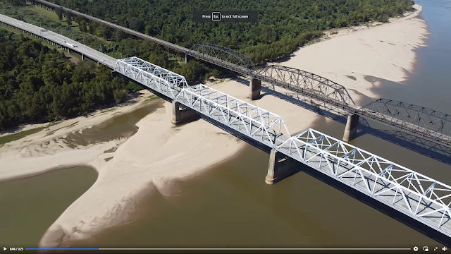
The official name is Owensboro Bridge. A common name is the Blue Bridge. This bridge used to carry US-231 across the Ohio, but US-231 was moved to a cable-stay bridge northeast of this town in 2002.
 |
| LC-DIG-highsm- 63937 Credit line: Photographs in the Carol M. Highsmith Archive, Library of Congress, Prints and Photographs Division. Carol M. Highsmith's photographs are in the public domain. |
 |
| Street View |
 |
| Street View |
Some of the photos in Bridge Hunter show that the bridge was getting brown (rust) in places. I'm glad to see that it now has a fresh coat of paint. Nathan Holth comments in Bridge Hunter that the deck was replaced in 2011.
 |
| Jeff Ratledge posted Today just before sunset, taken at the Riverfront park in Owensboro Ky. |
This is the post that brought this big truss bridge to my attention.
RiverWorks Discovery posted three photos with the comment: "Northbound on the Ohio at Owensboro heading towards the Glover H. Cary 'Blue Bridge' and its changing light display on Evansville Marine's M/V Angie A. Courtesy of Capt Steven Fancher."
 |
| 1 |
 |
| 2 |
 |
| 3 |
 |
| Tommy Matusz posted Owensboro Grain Dock. [I was going to crop this photo until I realized that the sun and its reflection was probably the intended subject of the photo.] |
I saw a post that said the river was really "angry," but they did not have a photo.
 |
| noaa |
April 2025 Flood:
 |
| 1:25 video UPDATE 5:12 p.m.- The Blue Bridge is back open. ---------------------------------------------- Thursday Update (4/10/25): Here’s a fresh look at the riverfront from earlier today before this afternoon’s rain rolled into Owensboro. The Ohio River is still on the rise, so closures around Smothers Park and Veterans Boulevard remain in effect. What’s closed: Veterans Blvd. and Smothers Park from Allen to Frederica St., including the Riverwalk from Allen to around McConnell Plaza. What’s open: Downtown hotels, restaurants, stores, the Convention Center, and other businesses are still open and ready to welcome you! We’ll continue keeping an eye on the water and will share. [According to some comments, the bridge was closed because of the Indiana side.] |
April 10 was near the peak of this flood of this flood.
 |
| noaa |
June 2025:
 |
| The Owensboro Police Scanner posted Bridge will be closed 90 days over the summer https://www.owensborotimes.com/.../owensboro-bridge.../... |
 |
| AP Imagery posted ** BRIDGE CLOSING ** The "Blue Bridge" in downtown Owensboro will temporarily close for 90 days beginning after July 4 for major repairs, including a full bridge deck replacement. Preliminary lane closures will occur June 9–11 with one lane remaining open. The closure, originally planned for six months, was shortened to reduce traffic disruption. The 7,200-vehicle-a-day span will reopen around early October, with full completion expected by November. |
 |
| Kentucky Transportation Cabinet, District 2 posted |
Daviess County Fiscal Court posted eight photos with the comment:
Single lane closures are planned this week on the Blue Bridge, ahead of a major rehabilitation project.The contractor will replace the aging bridge deck and perform other repairs to joints and concrete. A full closure of the bridge is scheduled to begin after July 4.The Kentucky Transportation Cabinet will limit the full closure of the bridge to 90 days or less.During the construction, crews will replace one 750-ft. long span of concrete decking while making repairs to a second span of the same length.Around 7,200 vehicles use the bridge every day. Once the full closure begins in July, drivers will need to use the William H. Natcher Bridge at Maceo or cross the Ohio River at Henderson.
Sherrie Stroud: They need to keep semi’s and big heavy vehicles off this bridge.
Mike Haney: Sherrie Stroud Ex mayor Payne tried that and found only Congress can close an interstate highway or bridge to interstate commerce.
 |
| 1 |
 |
| 2 |
 |
| 3 |
 |
| 4 |
 |
| 5 |
 |
| 6 |
 |
| 7 |
 |
| 8 |
Sep 2025:
 |
| Dubois County Dash Camz posted The Owensboro Blue Bridge repair project, which started in mid-July, is facing delays due to ongoing supply chain issues According to Kentucky Transportation Officials. The initial plan was to complete the project within 90 days, but it seems that's no longer feasible. Crews are working on replacing a 750-foot-long span of concrete-filled bridge decking and repairing another span of the same length. Since the decking covers the entire bridge width, a full closure was necessary, and traffic is being detoured to the Natcher Bridge. There is no current date that has been released for the bridge to open. When we hear of details we will share. Dewayne O'Bryan: When the concrete deck was removed that is when they found issues with the existing beams. You can't predict those issues. Anyone who has ever been in construction knows problems will arise and delays will be encountered |
 |
| Aaron Woodruff commented on the above post Picture without decking |
 |
| Owensboro Times posted Commonly referred to as the Glover Cary Bridge or the Blue Bridge, the Owensboro Bridge now has an opening date, and it's soon. https://www.owensborotimes.com/.../kytc-owensboro-bridge.../ KYTC: Owensboro Bridge set to reopen Friday [Jan 23, 2026] after months of delays, $1.5M in contractor penalties The work was supposed to be done by Oct 1. So they ended up pouring concrete in the Winter. The bridge typically carries about 7,200 vehicles daily. |
Jan 23, 2026:
 |
| Owensboro Foodies posted Heads up ! The Owensboro Blue Bridge is open ! Jon B.: U mean u can actually paint the old bridges!? Earl Barnard: Jon B. Well everywhere except Henderson. Jon B.: Yeah the Twin Bridges are disgrace and have been for 15 years |