Showing posts with label rrUP. Show all posts

Friday, July 11, 2025

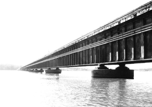
1954,1970,1987 Lake Houston Dam and UP Bridge on San Jacinto River in Houston, TX

Dam: (Satellite)
Bridge: (Archived Bridge Hunter; Bridge Hunter; no Historic Bridges; Satellite)

CoastalWaterAuthority

twdb
The spillway is 3,160 (963m) long, and the two earth embankments have a total length of 8,600 (2.6km). Between the spillway and the eastern embankment there is two Tainter gates.

n, Jul 2017

They plan to improve the spillway between 2028 and 2030 with a budget of $160m. [EngageHouston]

stantec
"Built in 1954, Lake Houston Dam is the only source of surface drinking water for over two million Houston, Texas residents."
[I could not find a date for the "elegant engineering solution."]

ReduceFlooding
"CWA is planning to add eleven new tainter gates to the dam for an additional 79,000 cubic feet per second of controlled discharge capacity."

The additional gates will allow them to draw down the lake level faster in anticipation of a major storm. They are also working on long term plans to replace the dam. [ReduceFlooding_Apr_2025]

CommunityImpact
The plan is "to add 11 gates to the spillway dam's existing four-gate structure." [However, only two of the holes in the existing structure actually have gates.]

This is the post that motivated these notes.
Union Pacific Railroad posted
This month’s calendar photo features UP 8393 leading a manifest train across Lake Houston, Texas.
📸 Photo by Stephen Foyt.

Patrick Feller Flickr, License: Creative Commons Attribution (CC BY)
Railroad Bridge over Lake Houston, Texas 1104091512BW
I had to be on the other side of the lake to check a project. A friend on that side has kayaks and we went out on the lake and headed toward the railroad bridge.

Monday, June 30, 2025

1913 11th and 15th Street Bridges over Thea Foss Waterway in Tacoma, WA

1913 11th: (Archived Bridge Hunter; Bridge Hunter; HAERSatellite)

1913 11th Street (Murray Morgan) Bridge


"Opened Feb. 15, 1913; rehabilitated 1957; closed 2007; rehabilitated 2012-3" [BridgeHunter_11th]

LC-DIG-highsm-50780, Carol M. Highsmith Archive, Library of Congress, Prints and Photographs Division, cropped

"Significance: The City Waterway Bridge is an early example of a vertical lift bridge, designed by the renowned firm of Waddell and Harrington. Three features made it remarkable, if not unique among vertical lift bridges of the day: the unusually great height of the deck above the water; the employment of an overhead span designed for carrying a water pipe, and the fact it was built on a grade." [HAER_data]

HAER WASH,27-TACO,9-

HAER WASH,27-TACO,9-
7. MACHINERY ROOM LOOKING NORTH WEST BY 270 DEGREES - City Waterway Bridge, Spanning City Waterway at State Route 509, Tacoma, Pierce County, WA Photos from Survey HAER WA-100

PAN US GEOG - Washington no. 51, c1919
Tacoma tide flats from Tacoma Bldg. digital file from intermediary roll film copy

15th Street Bridges


There were two bridges named 15th Street, and some of the sources confuse the two. The bridge in the foreground carried just the NP. The bridge behind it carried the UP and 15th Street Bridge.
Digitally Zoomed from above panoramic photo

This topo map also provides an overview of the two bridges.
1961/62 Tacoma North and South Quads @ 24,000

Note that each lane of 15th Street was cantilevered on the outside of the railroad span.
May 18, 1957 @ 20,000; ARA550460010152
.

1914-1973 NP 15th Street Bridge


NP's first bridge here was built in 1892. [BridgeHunterIndex] It was replaced by this 1914 bridge.
The 1914 bridge was abandoned in 1973 "due to damage from an erroneously routed Boeing load, likely removed shortly thereafter."
 HABS WASH,27-TACO,6--50
50. 15th Street Swing Bridge (1914). Built by the American Bridge Company. - Union Depot Area Study, Tacoma, Pierce County, WA

A colorized version of the above photo.
Western Washington History - Now in Color posted
Built in 1914, Swing Bridge, 15th St, Tacoma
Mike Stella: Grew up in Tacoma. That is NOT the 15th St. swing bridge. That is not even Tacoma. Pretty lousy post!

Dennis DeBruler commented on Mike's comment
The post is correct, https://www.loc.gov/pictures/item/wa0170.photos.168826p/. It was the NP Bridge. The UP+Road bridge was just south of this one.
.

1914-1983 UP+road 15th Street Bridge


BridgeHunter_191_ UP_15th

Sunday, June 22, 2025

Three UP Bridges over Mojave River in Afton Canyon

West: (Archived Bridge Hunter; Bridge Hunter; no Historic Bridges; Satellite)
Middle: (Archived Bridge Hunter; Bridge Hunter; no Historic Bridges; Satellite)
East: (Archived Bridge Hunter; Bridge Hunter; no Historic Bridges; Satellite)

All of the length information comes from the appropriate Archived Bridge Hunter webpages.

West


You don't have to worry about vegetation blocking your view in this area.
Street View, Jan 2024

Length of largest span: 178.0 ft.
Total length: 380.0 ft.

Middle


Street View, Jan 2024

Apr 2010 Photo by Craig Philpott via ArchivedBridgeHunter_middle

Length of largest span: 184.0 ft.
Total length: 328.0 ft.

East


Paul Jansson posted
Union Pacific's truss bridge over the Mojave River near the east end of Afton Canyon, just a few hundred yards west of W. Basin siding.  9/29/2012

Street View, Jan 2024

Length of largest span: 178.0 ft.
Total length: 370.0 ft.

Thursday, June 19, 2025

1887-1948,1989 Trail/UP/Boise, Nampa & Owyhee Guffey Railroad Bridge over Snake River south of Melba, ID

(Archived Bridge Hunter; Bridge Hunter; no Historic Bridges; Satellite)

"Built 1897, abandoned by railroad in 1948; saved from demolition in the 1970s; purchased & restored by Canyon County in 1989." [BridgeHunter]

"After the section of railroad south of the river was abandoned, Guffey Bridge was sold to Owyhee County for $1 in 1948.  Owyhee County sold it to the Idaho Historical Society in the 1970s.  Canyon County purchased the bridge in 1989 to include it in what later became Celebration Park.  The bridge has been refurbished so that pedestrians, equestrians, and bicyclists can use it to cross the Snake River.  The Guffey Bridge is the state’s largest historic artifact and was listed on the National Register of Historic Places in 1978." [endurance]

Trail View, Sep 2023

RRAdventures posted four photos with the comment: "Boise, Nampa and Owyhee Railroad."
1

2

3

4

It looks like it has pin connections.
Trail View, Sep 2023


Saturday, May 3, 2025

1887+1907+1967 UP and US-30+1963 I-84 Bridges over John Day River at Goff, OR

1887: (Bridge Hunter)
US-30: (Bridge Hunter)
1963 I-84: (Bridge Hunter; Satellite)

Goff, OR, is basically a label on a map where the John Day River joins the Columbia River. New bridges were built in the 1960s because the John Day Dam was going to inundate them. Also, the road bridge went from a 2-lane US-30 road to a 4-lane I-84 road.

1887 Railroad Bridge


Back then the railroad was the Oregon Railroad & Navigation Co. (OR&N). When retired, parts of this bridge was used to build the Armitage Bridge.

1907 Railroad Bridge


This looks like this is a pin-connected truss.
Photo from Worthpoint via BridgeHunter_1907

This shows the replacement bridge on the right because of the dam.
Press Photo via BridgeHunter_1907

1967 Railroad Bridge


Photo by R. W. Rynerson on 1967 UP excursion via BridgeHunter_1967
[The caption says the I-84 bridge is to the right of the locomotive.]

This view is after the dam became operational. We can see the John Day Dam in the background.
UP Photo via postcard via BridgeHunter_1967
The two truss spans are 300' (91m).

Union Pacific Railroad posted
📆 Flip the page on your Union Pacific calendar and check out May’s calendar photo, featuring #UP8057 leading a manifest train along the Columbia River near Goff, Oregon. Union Pacific transports a broad array of commodities and products important to Oregon and the national economy, including Hood River Valley pears, plant nursery products and Oregon lumber products vital to construction projects across the country. 
📸 Photo by David Honan.

US-30 Bridge


See also some of the above photos.
1958 view via postcard via BridgeHunter_US-30
"Destroyed by flooding in 1971 with construction of the John Day Dam"
[I disagree with the terminology of "destroyed by flooding." I prefer "inundated" to distinguish between sudden acts of nature and gradual acts of mankind. (I can't think of a gender neutral term for "mankind.")]

1963 I-84 Bridge


2010 photo by Richard Doody via BridgeHunter_1963

2010 photo by Michael Goff via BridgeHunter_1963

In this case, the terminology of "destroyed by flooding" is very appropriate.
"Built 1963; one span destroyed in 1964 flood; rehabilitated 1965." [BridgeHunter_1963]

I tried to imagine how the flood waters could have gotten high enough to take out the new bridge. Then I remembered that if a flood destroys a pier, the bridge is coming down. These piers might have been fine after the pool was full because the flow through here would be low. The bridge would have been over a lake instead of a wild river. (I'm wrong, see below.)
LostOregon
The collapse caused three deaths.

OregonLive, 18th of 23 photos
The person in the car was one of the three people who died because of the collapse. [sites]

OregonLive, 21st of 23 photos

I was wrong about the piers being OK for a lake instead of a river.

"In a nutshell, miscommunication and assumptions led to one of the bridge pier specs being changed from being sunk into solid bedrock to be placed on existing sand and gravel. The flood of 1964 undermined the pier and the bridge collapsed. Deaths were involved."


Brian Colburn, June 10, 2020Past and Present Views Along the Columbia River HighwayPermalink: https://www.facebook.com/groups/483015922488601/permalink/755044375285753 [I'm not a member of that group][sites]

sites, ArmChairEngineer credit link is broken
[The piers for the railroad bridge look much more substantial.]


The piers still look rather spindly.
Street View, Sep 2023

Friday, October 18, 2024

1908 Camas Prairie Railroad Lawyer's Canyon Bridge near Craigmont, ID

(Bridge Hunter broke Mar 22, 2023; no Historic Bridges; Satellite)

According to a comment by Drew Mango on a post, an abandoned section of the Camas Prairie Railroad has over 40 wooden trestles. The movie Breakheart Pass was filmed on one of the wooden trestles.
Chris Jones: the locomotive used in that movie, Great Western 75, is now at the Heber Valley Railroad in Utah

Street View, Aug 2023

As this sign explains, the route was jointly owned by NP and UP. According to a USGS map, it is now owned by Bountiful Grain & Craig Mountain.
D Dias, Aug 2023

This viaduct uses girders of different depths.
D Dias, Aug 2023
 
Bridges Now and Then posted
Idaho's Lawyer's Canyon Bridge under construction, May 4, 1908. (University of Idaho Library Digital Collections)

D Dias, Aug 2023

Tuesday, September 24, 2024

1894,1935 UP/SP/SSW(Cotton Belt) Bridge over White River in Clarendon, AR

(Archived Bridge Hunter; Historic Bridges; Satellite)

"That span was built in 1935 however the main part was built in 1894." [BridgeHunter comment]

Street View, May 2024

Redeker Rail Video & Photography caught the Big Boy at this bridge and posted these two photos.
1

2

West of town is a floodplain that has a textbook example of river meanders.
Satellite