These are notes that I am writing to help me learn our industrial history. They are my best understanding, but that does not mean they are a correct understanding.
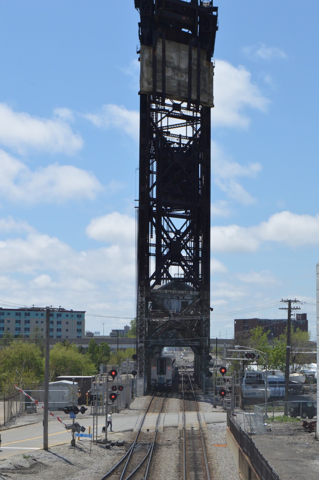
When I stopped by the Joliet Amtrak platform to see if my uncle and his friends were still railfanning, I noticed that an outbound Amtrak train was arriving on the CN+UP/GM&O tracks. It was going slowly enough that I waited for the text on the sign to scroll to "This is Joliet." to take my first picture, which is facing North. Note that the signal heads are turned sideways. This is because the route was converted to the new Positive Train Control signals a few weeks ago.
Because of the Superliner cars, I assumed this train was the Texas Eagle. According to the Amtrak schedule, the Texas Eagle is due at Joliet at 2:40pm. Since the time stamp on the following picture is 2:50pm, I believe the Texas Eagle assumption is correct.
Below shows the trains first stop so that passengers could load the front part of the train. You can see that there is construction in progress. The Amtrak platform is being moved from the west side of the tracks to the east side of the tracks so that the passengers do not have to cross the BNSF/SantaFe tracks to get to the CN+UP/GM&O trains. Note that the "dome car" is still north of the platform near the old signal bridge.
The train then pulled forward and stopped again with the rear part of the train at the platform at 2:55pm. The "dome car" is now south of the platform.
It then left the station at 2:59pm. So it left the Chicago area about 20 minutes behind schedule.
While I was getting portal pictures of the Canal Street RR Bridge, which is south of the 18th Street Viaduct, I noticed train movement north of the viaduct. There was an Amtrak train backing down the BNSF/CB&Q tracks under the St. Charles Air Line viaduct to the 16th Street yard.
11:50:02
Since I knew that as soon as it had traveled far enough to the west to clear the switch it would come forward towards me, I killed some time taking pictures of the Amtrak service area. This used to be the Pennsylvania coach yards. After about 5 minutes, the train appeared again on the Jefferson Connection.
11:55
11:55:54
11:56:02
11:56:12
11:56:24
11:56:42
11:56:48
I then crossed to the south side of 18th Street. The train went far enough south on the Metra/Pennsy route to clear the crossing as well as the turnout. In the left photo below, the turnout is still aligned for the main. In The right photo, the turnout has been switched to the service track.
11:57:46
11:58:14
The picture on the left is after it started backing up. Note that the crossing gates are down again. Also note that I caught an El on the Orange Line. The picture in the middle shows that it is using the western service track. The final picture is the last one I got before my camera refused to take more pictures because the battery was low. (The camera manual says it well flash a warning when the battery is getting low, but I have yet to notice it.) I had planned on taking more pictures including pictures back on the north side to record that the train was being shoved into the wash rack.
11:58:56
12:03:28
12:02:56
I had forgotten about this posting and wrote some more about turning this train when I described the Jefferson Connector. The postings are different enough that I'm going to let both remain.
This is Bridge 407. But I don't know if that is Rock Island's or CSX's number.
As a satellite image illustrates, the former Rock Island crossed the Des Plaines River at about a 45-degree angle. Note the above photo frames the next upstream bridge --- Jefferson Street Bridge.
When the Rock Island went bankrupt, the Chicago-area commuter service, Metra, operates the route from Joliet to Chicago. CSX operates the main route from Joliet to Utica. Iowa Interstate (IAIS) operates the remaining route in Illinois plus all of the route in Iowa. The IAIS and CSX have trackage rights over the Metra part to get to their freight yards.
Barriger [I think he took this photo before the above photo, but with a wider angle lens. Did they have zoom lenses back in his day? This photo follows the above photo in the collection, but they are obviously not in sequence.]
Steven J. Brown posted 7 pictures with the general comment:
Warning - post not suitable for more sensitive viewers, especially U-boat fans!
The screams of dying Chessie U-boats can be heard as the Iowa Interstate freight approached the Des Plaines River bridge in Joliet - March 1986.
Iowa Interstate GP8 7979 approaching the Des Plaines River in Joliet.
Iowa Interstate GP8 7979 crossing the Des Plaines River in Joliet.
Iowa Interstate GP8 7979 crossing the Des Plaines River in Joliet.
Iowa Interstate GP8 7979 passing a scrap yard along the banks of the Des Plaines River in Joliet.
Iowa Interstate GP8 7979 passing Seaboard 1311 in a scrap yard along the banks of the Des Plaines River in Joliet.
Iowa Interstate GP8 7979 passing a line of Chessie U-boats waiting their turn in a scrap yard along the banks of the Des Plaines River in Joliet.
Iowa Interstate GP8 7979 passing a line of Chessie U-boats waiting their turn in a scrap yard along the banks of the Des Plaines River in Joliet.
I went from 4:30 to 8:00 on the longest day of the year to try to catch a train during daylight. I didn't get a train, but I did get some river action. Also the sun was in the north part of the sky so that when it peaked out, this side of the bridge was lit up.
CSX SD50 8624 leadss 557 west over bridge 407 in Joliet, IL.
Halsted Pazdzior posted
A view through bridge 407. Built 1932 by the American Bridge Company and Ketler-Elliot Erection Co. Dimensions: Length of largest span: 302.0 ft. Total length: 552.0 ft. Deck width: 32.0 ft. 4/28/20 Dennis DeBruler I envy you guys that manage to catch a train on this bridge in the daylight. I one time spent an entire evening on the longest day of the year waiting for a train. I never saw a train. But I did catch some tows. https://www.google.com/.../@41.5190713,-88.../data=!3m1!1e3
Bill Molony posted
In this photograph; and eastbound Rock Island six-car intercity passenger train can be seen approaching the bridge over the Des Plaines River bridge in Joliet. Undated, but circa 1946.
William Brown shared J Pete HedgpethThat's Bridge 407...that entire area west of the bridge is completely industrialised now..I drive over the I 80 bridge about twice each year in the summer..It gets more unfamiliar to me every year. My perspective is 1961...
Dillon Harrison posted two photos with the comment: "After blocking a couple of grade crossings on the West side for about a half hour, The 153 was given its block to the EJ&E crossing from Bridge 407."
I knew they were building a new building west of the courthouse. I didn't know it was a new courthouse until I read Steven's comment.
20180917 5824
The new courthouse is opening up some new views.
Tony Raia posted
Iowa Interstate eastbound at Joliet. 3-14-19.
Nick Hart posted The Rock Island heritage unit is in charge of the morning Iowa Interstate eastbound as it crosses Bridge 407 in Joliet. The Silvis-Blue Island train (Z026-06 on CSX) is exiting CSX New Rock Sub trackage and entering Metra Rock Island District trackage on this sunny and warm morning. 07-06-2021 Juan Antonio Troncoso-Muñoz: Might sound like a dumb question but how much trackage belongs to Metra,then CSX until it turns into IAIS territory? HalstEd Pazdzior: Juan Antonio Troncoso-Muñoz west of Utica is Iowa. Utica to bridge 407 is CSX. The rest of the way east is metra.
Halsted Pazdzior posted
J946 heads west over bridge 407.
1/31/20 James L. LudwigHalsted Pazdzior - I don't recall anyone taking photos from the west approach- GREAT CHOICE!!!!!!!!!!!!!!!!!!1 Jeff Lewis How did CSX come to own that portion of the former Rock Island? And since it's isolated from the rest of the system, by what route does CSX use to access it? Dennis DeBruler I'm surprised that you got a photo during the daylight, especially considering how short the days are in January. I heard that Metra allowed CSX and IAIS to run only at night. And for the amount of time I have been at UD and taking photos of that bridge, I was convinced they ran only at night. On the longest day of the year, I set by the river upstream of the bridge all evening to try to get video of the bridge going down and up. But still no trains. Was this daylight train a fluke? Halsted PazdziorDennis DeBruler they've been rather late lately and usually come through during the middle of the night. But this past few weeks they've been coming mid day. You're best daylight train would be IAIS SIBI which usually goes over there bridge around 8:30am right after the inbound metra rush.
Dennis DeBruler commented on Jeff's comment on Halsted's post
I presume they offered the RI bankruptcy judge more money than EJ&E was willing to offer. EJ&E took over operations when the RI shutdown, and they were surprised that they did not get it.
I confirmed with a former RI employee that CSX does a shoving maneuver between north of Blue Island Junction and Barr Yard so that they can use the connector on the west side of Blue Island Junction.
This sign in Seneca, IL, is how I learned that CSX went west of Chicago. Jun 27, 2014 Jeff LewisThanks Dennis.
A rare daylight CSX Barr Yard to Ottawa train heads west through Joliet. Some recent demolitions opened up a lot of space. In the background you can see the new Will County Courthouse, which recently opened, and bridge 407.
10/23/20
Comments on a HalstEd's post
Dennis DeBruler commented on Halsted's post
I just had Facebook refuse my comments because they were a violation of Community Standards. It called them Spam. My links were to Google Maps and the historic Illinois aerials. That is not self-promoting. This is the second time now that Facebook has trashed my work.
I'm not going to try to replicate what I said about the industrial spur ramps on the north and side south sides of the mainline at the Des Plaines Street overpass, but I will include the 1939 photo extract that shows the spurs. https://clearinghouse.isgs.illinois.edu/.../0bxk02116.jpg Halsted PazdziorDennis DeBruler interesting stuff. I know the north ramp was to the coach yard.
Peter Zimmermann also provided more information on how to catch the IAIS train. But that post got removed?! Fortunately, I still have some info in my email:
Peter Zimmermann: The train used to leave around 6:45 pm or so on the weekdays, but then
they switched it to not before 7:30 pm for departure out of Blue Island.
Someone else commented that it would not get to Joliet before 9:00 pm.

 Below shows the trains first stop so that passengers could load the front part of the train. You can see that there is construction in progress. The Amtrak platform is being moved from the west side of the tracks to the east side of the tracks so that the passengers do not have to cross the BNSF/SantaFe tracks to get to the CN+UP/GM&O trains. Note that the "dome car" is still north of the platform near the old signal bridge.


