Showing posts with label wwDam. Show all posts

Sunday, August 31, 2025

Horlick Dam on Root River in Racine, WI

(Satellite)

Street View, May 2023

USACE, Chicago Division posted
We are happy to announce that #USACEChicago and Racine County, Wisconsin have officially signed a Project Partnership Agreement for the Horlick Dam: Root River Restoration Project under the U.S. Army Corps of Engineers Great Lakes Fishery and Ecosystem Restoration (GLFER) program! 🖋
✅ With this agreement in place, work can now begin on designing the recommended plan to remove the 19-foot [3m] tall low hazard dam structure — a major step toward revitalizing our river ecosystem.
📐 Over the next year, construction plans and specifications will be developed, leading to a contract award and project implementation.
🌿 Why this matters:
Restores ~7 miles of upstream river habitat
Opens fish passage to 160 miles of river and tributaries
This is a major win for Racine County, our environment, and future generations who will benefit from a restored, free-flowing Root River!

Of six street views, this was the lowest flow.
Street View, Aug 2012

And this was the highest.
Street View, Aug 2007

Tuesday, August 19, 2025

1970,2020 110mw Robert S. Kerr Lock & Dam on Arkansas River near Sallisaw, OK

(Satellite)

Street View, Sepo 2024

USACE, Tulsa District

The 7,230' (2.2km) long dam has a maximum height of 75' (23m) above streambed. The 900' (274m) long spillway has "eighteen 50- by 44-foot-high tainter gates" with a capacity of 1,542 kcfs. The lock is a standard 600x110 with a normal lift of 48' (14.6m). The powerhouse has four "27,500-kW Kaplan-type units." Each unit can discharge 34,000 cfs at rated capacity and 41,000 cfs at full overload. [USACE_data]

I wonder where the towboat operates that requires a retractable pilothouse.
okhistory, Credit: Oklahoma Historical Society, photo by Jim Edmond

Andy Michel posted 14 photos with the comment: "Some cool photos I took during our tour of Robert S. Kerr Lock & Dam.— with Joshua Cox and Joe Bodolay at Robert S Kerr Lock & Dam 15."
1

2

3

4

5

6

7

8

9

10

11

12

13

14

Andy also included a video.
Screenshot 1

Screenshot 2

Andy Michel posted
Got an awesome tour from Joshua. 
Thank you very much!!!— with Joshua Cox and Joe Bodolay at Robert S Kerr Lock & Dam 15.

Wednesday, August 6, 2025

State Street Bridges over, and Dam on, Oswegatchie River in Heuvelton, NY

1870s Bridge: (Archived Bridge Hunter; Bridge Hunter)
1917 Bridge: (Archived Bridge Hunter; Bridge Hunter; no Historic Bridges; Satellite)
1923 1mw Dam: (Satellite, it has a fish ladder on the south side.)

Behind the pole in the center is part of the fish ladder.
Street View, Jun 2025

Bridges Now and Then posted
Construction on Heuvelton’s concrete bridge in 1916. Heuvelton, NY. (North Country at Work)
Art Suckewer: The old bridge is an 1870s Wrought Iron Bridge Co. bowstring through truss.

Postcard via BridgeHunter_1870s

It looks like 2 of the 6 trunnion gates have been replaced.
Street View, Sepo2018

Are the replacements movable?
Yes. Data calls them "Other Controlled2." But I couldn't figure out how to look up the meaning of "Other Controlled2." Are they inflatable?
Street View, Jun 2025

NorthCountryAtWork
The dam was constructed in 1923.

NorthCountryAtWork

The dam is 284' (87m) long and 19' (6m) high with a hydraulic height of 35' (11m). [data]
The 2 units have a combined capacity of 1mw. [HydroReform]

Sunday, August 3, 2025

1967 160mw Green Peter Dam and 1945,1988 Short Covered Bridge on Santiam Rivers near Cascadia, OR

Dam: (Satellite) The dam is on Middle Santiam River
Bridge: (Archived Bridge Hunter; Bridge Hunter; no Historic Bridges; Satellite) South Fork Santiam River

Street View, Aug 2013

USACE, Portland District posted 0:45 video
The river flows downstream of our dams can speed up at any moment.
This is especially critical in the summer when more people are paddling on Willamette Valley rivers and we’re turning hydropower on and off to keep up with electricity demand.
The most dramatic changes can happen below our Green Peter Dam, where the narrow canyon between the dam and Foster Reservoir can fill quickly during peak hours.
We've posted warning signs, but we’re always looking for ways to improve safety at our locations, which is why we remind you to wear a properly fitted, Coast Guard-approved life jacket whenever you’re in or on the water.
Wearing a life jacket drastically improves your chances of surviving dangerous situations.

USACE
The dam has two 80mw units with a hydraulic capacity of 4,600cfs.

I found this bridge while looking for Cascadia, which is the post office town for the dam.

Street View, Aug 2013

HAER OR-120-7
VIEW LOOKING DOWNSTREAM, WEST 280 DEGREES - Short Bridge, Spanning South Santiam River at High Deck Road, Cascadia, Linn County, OR

"Significance: Built in 1945 to replace an earlier bridge at this site, Short Bridge illustrates Linn County's distinctive open-sided housing that was designed to increase visibility and reduce wind resistance. It is one of the few covered bridges in Oregon to incorporate modern split-ring connectors, which made wood structures competitive with those of steel in the mid-20th century. Short Bridge was rehabilitated in 1988 and continues to carry vehicular traffic, including logging trucks." [HAER_data]

2011 Photo by Michael Goff via BridgeHunter

The Short Bridge is the sole survivor of the covered bridges which crossed the South Fork of the Santiam River and is one of the few remaining in the county to have a wooden shingle roof. The span is Linn County's most eastern covered bridge.
When the wooden-housed structure was built, the bridge was known more commonly as the Whiskey Butte Bridge but was renamed for a long-time area resident, Gordon Short.
Quite often visitors are surprised by ducks, deer and other animals in the vicinity of the bridge. During the summer, fishermen on and under the bridge cast lines into the cool waters of the South Santiam River.
(Reference: Roofs Over Rivers, by Bill and Nick Cockrell)
[ArchivedBridgeHunter]
Jimmy G, Jun 2025

Tuesday, July 15, 2025

1938 55mw Buchanan Dam on Colorado River near Kingsland, TX

(Satellite)

lcra
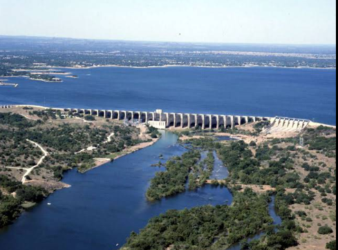
This is the furthest upstream of the six Highland Lakes dams on the Colorado River in Texas. This dam and Travis Dam are the two storage dams for water supply and flood control.
"In 2021, LCRA completed a $51.1 million project to upgrade and strengthen the floodgates, hoists and other facilities at the dam."
"145.5 feet [41.3m] high, 10,988 feet [2249m] long"
It has 37 flood gates with a total discharge capacity of 348kcfs.
Top of dam: 1,025.5'
Spillway: 1020.35'
Full: 1020'
It holds 880,356 acre-feed when full.
[I think this is the first big storage dam I've seen that doesn't have a conservation pool that is lower than the flood pool.]

The maximum design water level is 1024'. The historic high was 1021.4' on Dec 20, 1991, and the 100-year flood is 1021'. "Currently, Lake Buchanan is operated at two normal pool levels, 1,018 and 1,020 feet above mean sea level, for May-October and November-April, respectively." [twdb]

Bill Freauff, May 2023

[I lost the reference for this photo]

July 14, 2025 Flood

As of July 15, 2025
WaterDataForTexas

Historic Levels:
WaterDataForTexas

They first opened two gates in the middle spillway.
kxan
"Floods force Buchanan Dam to open flood gates for first time in years" [Since 2019.]

Facebook Reel

Those gates must be some of the small gates. 
lcra

Four gates opened is the highest number that I've seen so far.
LCRA posted 0:36 video
Coordinated floodgate operations across the Highland Lakes system. This drone footage, shot over the past few days, shows floodgates at Buchanan Dam, Wirtz Dam and Starcke Dam, as LCRA manages water from recent flooding in Central Texas. Lakes Buchanan and Travis are designed to fill during major weather events, and another reason why staying flood-ready is crucial in Flash Flood Alley. Our thoughts remain with those affected by this devastating flood.

Meteorologist Avery Tomasco posted
Lake Buchanan is now at its highest elevation in 6 years
Lake Travis is now at its highest elevation since August 2020
Both still rising this morning. Unbelievable volume of water entering the system over the last 10 days

Brandon Butcher posted
MORE SOUTH TEXAS FLOODING - Evacuations are ongoing on the San Saba River, which will crest tonight close to the level of last time, but the heaviest rains have not concentrated in the Guadalupe River basin this time.

Kristen Currie posted
As of today (7/14), four floodgates are open at Buchanan Dam, one floodgate is open at Wirtz Dam, multiple floodgates are open at Starcke Dam & water is flowing over the spillway at Inks Dam. 
The Highland Lakes system is doing what it’s built to do — move storm runoff downstream, with as much control as possible, to store in our drinking water reservoirs.
📷: Deana Gideon | Buchanan Dam

It is interesting that they open some of the gates all of the way instead of all of the gates some of the way. Obviously, all of the gates have dedicated lift machinery so it would be easy to partially open all of the gates. I guess they open just the gates in a primary channel.
Hill Country Scanner posted 0:31 video
Lake Buchanan floodgate operations
July 14, 2025 courtesy share with Hill Country Scanner

A Buchanan Dam gate structure is in the right background.
Valentine Lakeside posted 2:43 video
This is below Buchanan Dam, where four gates are flowing into Inks Lake. That water will make its way to LBJ.

I wonder what type of obstruction in the river causes this turbulence.
Same Video

On the right side of the above video we can see a dock under water.
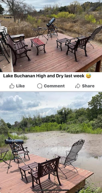
Street View, May 2024

Guy Hood commented on a post
I waited years to see this day! Please don’t let the water go away again!

Facebook Reel


Jul 24, 2025:
It looks like they are down to 3.5 gates open.
Facebook Reel

Same reel

Same reel