Sunday, September 29, 2019

The parts of a lattice crane and bent boom stops


Chris Evans posted
Basic lattice boom crane components
Will T Henson 3900 t
At first, I skipped the above parts diagram as not worthy of its own post. But on the same day I came across a closeup of the boom stops because they were damaged. Judging by the comments on the post below, some of the things that might cause the boom to come back too far:
  • the boom was high with a heavy load and the load was suddenly released
  • the operator had the boom too high when he traveled up a "hill;" e.g. onto some mats
  • the crane is old and doesn't have a high boom kick out, or the kick out is adjusted wrong, or the operator was in kick out override mode. And then the operator raised the boom too high.

Jonathan Mark posted

Wayne Hill commented on Jonathan's post
Ours was a little more back!


Saturday, September 28, 2019

That Sucks! (Tank Car Vacuum Implosion)

"That sucks" because of the vacuum and because an employee made a lot of scrap metal.

Les Baldwin posted three photos with the comment: "Tank car cleaning gone bad, steam injection through dip tube to heat car to boil off residual material in preparation for sending car to shop, Steam shut off, valves closed, car cooled off, pulled vacuum and this was the result."
Joe Dockrill shared
Russell Baucum And those tankers are built with heavy-duty steel in case of derailments to contain the fluids!🤔
Wes Garland It didn't perf......bendy is stronger than rigid...milk comes in plastic bags in Ontario.
1

2

3

It appears the placard is 1993. That would be fuel oil.

Stanley Silva posted
Tank car collapsed by internal vacuum. This was accomplished by actually removing the air with a vacuum pump to show what can happen if tank car is steam cleaned and vent vales left shut and not allowing the air pressure to equalize as the tanker cools.
[I did not dig through the 134 comments, but my did catch a couple of interesting comments.]
Lang Thompson: That happened to a 750000 Gal Stainless Steel tank that was being steamed where I worked. Steam and a cold rain shower form a powerful force. Thankfully my finger prints weren't on that disaster.
Chris Vieira: Happened in a transload yard up in montreal once but for plastic resins. One hopper was totally like that, crushed cane. [I didn't realize that covered hoppers sealed will enough to hold a vacuum.]

David Buccolo commented on Stanley's post
I had to respond to a customer track one very early Sunday when they failed to vent a tank car of ethanol luck would have it no leaks.


Friday, September 27, 2019

BNSF/GN Two Medicine Trestle and US-2 Bridges

GN: (Bridge HunterSatellite)

It looks like they have stared disassembling the falsework that was used to help construct the main truss.
Joe Dockrill posted
Great Northern's Two Medicine Bridge in Montana in 1891.
 
Marty Bernard posted
1. Great Northern Railway trestle over Two Medicine [River Montana] in course of construction circa 1887.

LarryDoyle commented: The single track steel structure which replaced it (similar in design and appearance) is still in daily use in Montana.

LarryDoyle also commented: Lewis and Clark pursued the Two Medicine River in their search of a Northwest Passage. They gave up, deciding the pass impossible, If they had only gone another 6 miles they would have found it. Instead, they backtracked about 200 miles or so and instead followed the Yellowstone River to find a land route to the Pacific. Jim Hills construction engineers succeeded where Lewis Clark failed.

Photographs and captions from the Minnesota Historical Society

Marty  Bernard shared

Ian Lothian posted
Another favorite bridge that I like to photograph, even its its over 5,000 miles from home! This is Two Medicine Trestle on BNSF's Hi-Line sub, east of East Glacier Montana. The Great Northern use to use this view for publicity to try and attract visitors to Glacier National Park. Its a nice piece of engineering in a fabulous part of the world and looks even better when there's a train crossing it. This was an eastbound Intermodal on 21 July 2006 with 4903 leading 5372 and 5271.

Photo by Loco's Loco Co., License: Creative Commons Attribution (CC BY)
[Unfortunately, Google pulled the plug on their panoramio.com. I could understand them stopping the service by not letting any new photos being uploaded. But to throw away all of the photos that people contributed in good faith continues to blow my mind. It makes me wonder if someday they will trash the contents of this, and other blogspot.com contributions.]

Street View

American-Rails.com posted
In this publicity photo, a handsome set of new Great Northern FT's, leading a string of new 40-foot boxcars, pose on Two Medicine Bridge, Montana in the summer of 1944.
[A comment indicates that this is the BNSF mainline.]

While looking for a street view, I discovered construction photos of a new US-2 bridge. A satellite view shows just the new bridge. The bridge being replaced is certainly very narrow by today's standards.

Street View

Street View


Thursday, September 26, 2019

Chicago Fire Engine 98

(3D Satellite)

As part of the 150th Anniversary Celebration of the Water Tower, Chicago Fire Engine 98 had an open house that we spotted on our way back to the parking garage. ($34 for 2 hours) I've read that it was the oldest engine house in Chicago. But the firefighter that we talked to said it was the third oldest until the oldest was closed. That is, it is currently the second oldest. He didn't know what the current oldest one is.

It has the same castellated, dolostone architecture as the water tower and pumping station. (The traffic on Chicago Avenue in this area was remarkably light.)
20190914 9306 gimp+50+20 plus paint
The building was in the shadow of the skyscraper that is on the south side of  Chicago Avenue.

Normally, an ambulance is parked to the left of the pumper. They had the ambulance parked on the street to make room for the people.

What looks like a broom closet is actually...

...the bottom of the tower in which they dry the hoses.


Some of the firefighters do use the fire pole.

During the two years the firefighter we were talking to had been assigned to this engine house, he has gone to three stove fires, one restaurant and two residential. None of the eight false alarms where malicious; they were all accidental. The ambulance is much more busy than the pumper. In fact, the pumper sees more action providing assistance when there is a problem out on the lake. He was not on duty the day his colleague, who was about 10 feet away from us talking to some other people, saved a woman who was pulled out of the water using CPR.

The top rack below holds the cloth pressure hoses that are used to spray water on the fire. They are the ones that are still dried in the hose tower after each use. The big 6" rubber hoses in the lower left go from the hydrant to the pumper. The hoses next to the hydrant hoses supply water to snorkel trucks. The 3" pressure hoses in the lower right are used to connect the pumper to the standpipe of a skyscraper. Their pumper is one of four in the city that has a three-stage pump to produce the higher pressure necessary to shove the water to the upper stories served by a standpipe. Most trucks have just a two-stage pump.

He mentioned that the room in back, which is now the kitchen and lounge area, was the stables. When we lit up at that fact, he took use out back to show us the door in the upper story that was used to put hay in the loft. It still has the beam that held the hoist for the hay.

A couple of the decorative touches.


Wednesday, September 25, 2019

Tennessee-TombigBee (Tenn-Tom) Waterway Overview

USACE via EncyclopediaOfAlabama

TennTom

Lisa Ann posted, cropped
Most active or previous Loopers already know this, but for those who don’t….Our, PerfectSeas new leg of the trip is the Tennessee-Tombigbee Waterway.
It started athe the pool level of Pickwick Lake in Tennessee and runs downhill into Mobile Bay. We will lock down 341’ over the distance of 450.4 miles to Mobile Alabama.
The rivers currents are with us at a whopping 0.5 knots.
There are 3 sections to the waterway, the divide cut, where Pickwick Lake is 414’ above sea level, the canal section, consisting of dams and pools connected to form a 9’ deep waterway along the canal, and repeats the process to the 6th and final lock. The last part of the waterway is called the river, where is was straightened. There will be one more lock in the Black Warrior section. So it’s a total of 10 locks. Nine of them drop us about 30’ and the largest, which we went through yesterday dropped us 84’.
This waterway system was proposed back in the 1700’s, but was finally started in 1972. It cost 2 billion dollars, when it was finished in 1985. More earth was moved in this system, than in the Panama Canal system [my emphasis].
Crazy!
George Sirk: 13 locks from Pickwick to Mobile. Last one is Coffeeville, which doesn’t show on this map.
Joey Ritchie shared

"The Tenn-Tom was controversial from its inception, and optimistic predictions of its economic benefits by the U.S. Army Corps of Engineers never materialized. Originally estimated to cost $323 million in 1970, the total cost at completion in 1984 was almost $2 billion. Funding was approved in 1968.  "A combination of environmental groups, the railroad industry, and members of Congress from other regions of the country were successful in blocking funding for years. To much of the public, the Tenn-Tom came to epitomize "pork-barrel politics" at its worst. The estimated economic benefits of the waterway by the Corps of Engineers were derided by opponents as unsupportable based on projected traffic volume, a challenge that later proved to be true. The project was deauthorized at one point, and Pres. Jimmy Carter sought to cancel it." Construction began in 1972 and "proceeded over the next 12 years, consisting of 10 locks and dams and 234 miles of navigable waterway and the excavation of 310 million cubic yards of earth, more than was excavated for the Panama Canal. Eight railroad bridges and 14 highway bridges were either relocated or rebuilt. The single-greatest challenge was the construction and excavation of the so-called Divide Cut. This 29-mile portion of the waterway connected the Tenn-Tom with Pickwick Lake. The cut is 280 feet wide and at its deepest cut required the removal of earth to a depth of 175 feet. This single section of the waterway alone took eight years and required the removal of 150 million cubic yards of earth, almost half of the total excavated for the entire project. The Tenn-Tom encompasses 17 public ports and terminals, 110,000 acres of land, and another 88,000 acres managed by state conservation agencies for wildlife habitat preservation and recreational use. The elevation change between the two ends of the waterway is 341 feet, or a drop of 1.46 feet per mile....Prior to its construction, however, the Corps of Engineers predicted that the waterway would float 27 million tons in its first year of operation. As the result of a variety of fluctuating economic conditions including low demand for coal and loss of overseas markets grain, however, the Tenn-Tom has peaked at only about 8 million tons per year thus far." And coal and timber was 70% of that peak. [EncyclopediaOfAlabama]

The locks are the same 600'x110'x9' standard as the Upper Mississippi and Illinois River waterways.


USACE
The Divide Cut under construction in the early 1980s

I learned of this waterway from a Sept. 20, 2019, Chicago Tribune Article by Jay Reeves with the headline: "From hope to South’s ‘big ditch’." The sub-headline was: "$2 billion shortcut to Gulf of Mexico fails to yield boom."
The Corps and supporters justified the spending with predictions that shippers would send 29 million tons up and down the Tenn-Tom annually, and the opening ceremony proclaimed it the pathway “to a dream of orderly growth and prosperity for all the people of this region, and for the nation as a whole.”
Corps statistics show an average of 7.2 million tons of cargo traveled the Tenn-Tom annually over the past decade, just a quarter of the initial forecast. By comparison, 304 million tons of cargo went up or down the Mississippi River, which can accommodate larger loads, over the same period.
“It’s the lack of development. It just hasn’t been what they thought it would,” said Mitch Mays, administrator of the Tennessee-Tombigbee Waterway Development Authority.
Alabama and Mississippi are renewing efforts to promote the Tenn-Tom, he said.
Officials say there’s no single reason companies didn’t flock to the waterway. The rise of overseas industry hurt domestic businesses just as promoters were trying to sell the Tenn-Tom as a new route. Some blame the decline of coal and poor promotion for the lack of growth; others cite an inadequate workforce and the inertia of generational poverty.
“The poor counties that were poor and were in poverty were that way for other reasons,” said Allison Brantley, who promotes economic development in Sumter through the University of West Alabama.
[ChicagoTribune]
Jay Reeves/AP via Chicago Tribune
[A Steel Dynamics plant is one of the few economic bright spots along the waterway. But they built the plant a few miles away from the port.]

The waterway was closed in March, 2019, because of sandbars left by flooding. It cost $10m and three weeks to dredge an emergency access channel to the lock at Aberdeen. [USnews]
DailyTimesLeaderThis aerial shot shows the shoaling on the Tenn-Tom Waterway just south of the Aberdeen Lock and Dam.
It will take six to eight weeks for a short-term fix as the Corps of Engineers brings in a dredging crew to remove tens of thousands of cubic yards of silt that has created a massive sandbar that has the river so shallow it’s only about knee deep in spots.
Long-term fixes will take four or five years, according to the Corps chief operations engineer.
The Corps’ in-house rig is clearing a 200-foot long sandbar at mile marker 410 in southern Tishomingo County. That should be finished this weekend. Kentucky Lock on the Tennessee River near where it meets the Ohio also should be cleared by this weekend, as will a clog at Coffeeville, Ala. According to Tenn-Tom Waterway Corps Operations Manager Justin Murphree, the dredging rig should be in place at Aberdeen in three weeks. It’ll take a least three weeks to dredge out 150,000 cubic yards of silt and debris to open a one-lane barge channel. The sandbar that has closed the river is made up of an estimated 400,000 cubic yards that will take much longer to remove.
Murphy and veteran river watchers say the shoaling that has blocked the river has never happened before in the 35 years since the waterway opened. And they don’t see this episode as a sign of a long-range problem or channel issue. “This is a once in a generation type thing. Even the carriers say they’ve never seen this in 44 years of being on the rivers,” Mays said.
“There’s going to be a big reduction in tonnage because of this. And part of the federal money we get is based on tonnage. That’s one of the things Mitch is talking to them about. This has long-range implications,” added Agnes Zaiontz, the business manager for the Tenn-Tom Waterway Development Authority.
The waterway was closed again in Sept, 2019, because an barge accident created a hazardous oil spill in the Jamie Whitton L&D at Bay Springs Lake. "The oil is contained inside the lock and the Corps of Engineers said there is no threat outside of the lock area." [WTVA]

This map shows what little impact the waterway has had on barge traffic. The numbers for the scale are 250, 125 and 62.5 million tons per year. And the intercoastal waterway, except between Texas and New Orleans, is not used unless pleasure boats use it.
WashingtonPost, 2016


For future reference, a list of hydropower facilities in the Mobile District.
USACE via USACE

USACE-TennTom posted
On this day in 1984 construction was completed on the Tennessee-Tombigbee Waterway! The photo below is called "Historic Meeting of Two Rivers" from a National Geographic article published in 1986. It features the historic meeting of water from the Tennessee River, foreground, joining the Tombigbee River near Amory, MS.
Photo by: Sandy Felsenthal

Pickwick Lock shared
Joe Clark: Glad this was completed using the plan b method. Although I am sure the nukes would have been more exciting.
[That is a BNSF/Frisco bridge in the background.]
The Mississippi River and the fifteen road and six railroad bridges that cross it are part of a regional transportation net the developed between 1800 and World War II. The story of bridges in the Upper Tombigbee river valley is part of the story of the changing relationships between the river, the railroads, and the highways in NE Mississippi. The first settlers of European stock reached the area when Robert Fulton and others were perfecting the steamboat. During the 19th century, the river was variously and simultaneously the principal avenue of transportation and its chief obstacle. The ante-bellum riverboats carried the bulk of commerce; landings spotted the riverbank, and some became villages only because bad roads and river crossings made the towns inconvenient. The railroads were first conceived of as feeders to the river; in the end they entirely supplanted it. The highway bridges linked the towns with their hinterlands and made the railheads as convenient as the riverbanks. By the time Henry Ford had sent the automobile swarming across the continent, the Tombigbee was irrelevant as thoroughfare or obstacle.
-- Historic American Engineering Record
[BridgeHunter]
24:35 video of the history of the Tenn-Tom  Of note at 6:48 is the "chain of lakes" construction used in the canal section. This is one of them. The upper reach of steamboat navigation was Cotton Gin Port. [7:13] My current understanding is that was at Amory, MS. I'm confused because the locks have been renamed since this video was made.

When you see what the original river looked like back in the steamboat era, it continues to amaze me how far they travelled inland before railroads and paved roads were developed. (Although this may have been just upstream of Cotton Gin Port.)
USACE

I was surprised that the Tenn-Tom looks about as crowded as the Mississippi. Is that because the Mississippi is low and some tows are using the Tenn-Tom as an alternate?
16:58 video @ 0:45


Tuesday, September 24, 2019

Westmont/Gregg Made Bricks

I didn't realize that bricks were made in the Western Suburbs until I read the post below. I knew there was a lot of brick manufacturing around Goose Island, South Chicago and in Streator, IL after the 1871 Fire because of a city ordinance that ruled out reconstructing with wood. [DeBruler]

The house that William L. Gregg built for himself with one of this first batches of bricks has been preserved in Westmont (Satellite).
20190925 9459

Forgotten Railways, Roads & Places posted
Westmont Station was originally known as "Gregg".
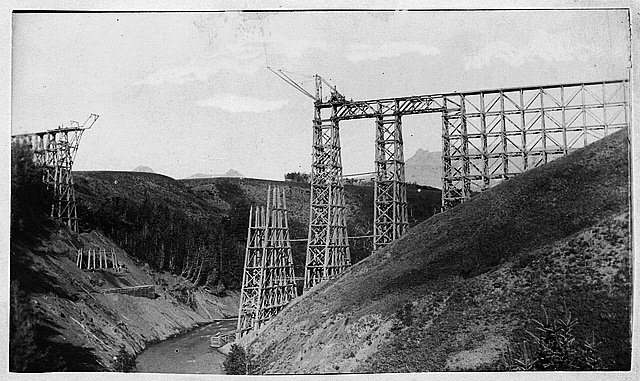
Nothing was more important in paving the way for future Westmont than the building of the Chicago/Aurora branch of the C.B. and Q. Railroad, begun in 1862 and completed two years later. At this time, a large share of the future Westmont was bought up by the Phipps Industrial Land Trust. Shortly after the Chicago Fire of 1871, some of this land was sold to a number of brick manufacturers jumping at the chance to supply bricks for the rebuilding of Chicago.
The most memorable brick manufacturer was William L. Gregg who chose the highest point of land along the C.B. and Q. Railroad for his company so that shipping by steam locomotive would be downhill with a full load of brick. In the spring of 1872, Gregg began manufacturing bricks under the name of Excelsior Brick Company. His company started with a capital investment of $250,000.00, employed 120 people and produced 70,000 bricks a day. While here, Mr. Gregg invented and patented a triple pressure brick machine which revolutionized the brick industry. Using this method, his bricks could withstand 100,000 pounds of pressure without cracking or disturbance of any kind.
Gregg built his home to showcase his product. Records indicate he lived in the home for approximately three years. He considered himself a dealer in patents as he invented sixteen different pieces of brick making apparatus.
By 1900, brick making declined. The area continued to grow and the flag-stop on the “Q” was known as “Gregg’s Milk Station”. The name of the station was shortened to “Gregg”.
After Gregg left the area, the home had various owners and was used as a farm house, restaurant, funeral home, speak easy, and recreation center. Later it was owned by Holy Trinity Catholic Parish and used as a home for a priest for a short time before becoming home to several nuns.
Eventually the home became run down and was going to be demolished. In 1976 the Westmont Area Historical Society was formed to save the home. It was moved one block from its original location on Cass Ave. to its current location on Westmont Park District property. After extensive restoration, it opened as a museum in the fall of 1981.

History via: https://www.westmontparks.org/parks-facilities/gregg-house-museum/
The oral presentation at the museum provided some more information. Gregg was living in Philadelphia when he heard the Chicago rebuild could not use wood and would need a lot of bricks. So he moved to the Chicagoland area to be a part of the rebuild economy. The 80-acre parcel that he bought was typical for the day. His house was originally on Cass. The Holy Trinity Catholic Church owned it and actively used it. But in the 1970s they wanted to tear it down to expand. The Westmont Historical Society was formed, and they moved it a block East. Since the new location was still on the original 80-acre plot, the 1977 move did not invalidate its inclusion on the National Register of Historical Places in 1980.

Gregg designed and built is own equipment to mix, cut and dry the bricks. His machines to mix and cut the bricks ensured that they were of a consistent composition and size. His kiln was designed to dry all of the bricks in it at a uniform rate.
The home of William L. Gregg was constructed in 1872 with bricks manufactured in the newly operating Excelsior Brick Manufacturing Company. Gregg's brickyard, a large and carefully located one for that time, employed 120 workers and manufactured 70,000 bricks a day. Mr. Gregg also invented the triple pressure brick making machine, which revolutionized the brick making industry. He died in 1891 and a few years later, the Excelsior Brick Company ceased production. [Brochure]


I have determined that the above topo excerpt was from the 1901 Riverside Quadrangle @ 1:62,500. The left side of the excerpt is the left side of the quadrangle. The oldest topo for the Westmont area is 1891:
USGS 1891 Riverside Quadrangle @ 1:62,500
By 1927, the suburbs along the CB&Q had "filled in."
USGS 1927 Hinsdale Quadrangle @ 1:24,000
I took a couple of photos of the garden that is behind the house.


They had three (glass covered) frames for the diagrams and text of some of his patents.

A kiln:

A "Brick Mahcine:"

A drying building:

Each Summer they have a different theme for the exhibits in their two front rooms. This year was transportation. So one room was about the CB&Q Railroad.

This is the first time I've seen Lisle included in the list of existing western suburbs. And Hinsdale had a different name. But now I can't remember it. Bush Hill is what is in my brain cells. But I don't trust them.

The second room was about the I&M Canal.

Two closeups to try to get a readable resolution of the facts. If you click an image and use your browser's F11 option, you should get a better view.


This display includes historic and current views of the Fox River Aqueduct in Ottawa, IL.

I took this image for my Gaylord notes.

The museum is full of permanent exhibits of "old things." This is just a sampling. Note the washing machine. The stove had gas burners. They had a sign that explained the temperature of the two ovens was not automatically controlled. Each oven had a thermometer, but a human would have to adjust the controls to maintain the correct temperature. The compartment on top was a warmer.

Early cathode ray tubes were round because that was the strongest shape to withstand the pressure of holding a vacuum inside.

Most old cash registers I have seen are quite fancy. I'm sure this is more representative of what was actually used.

The oral presentation explained that 
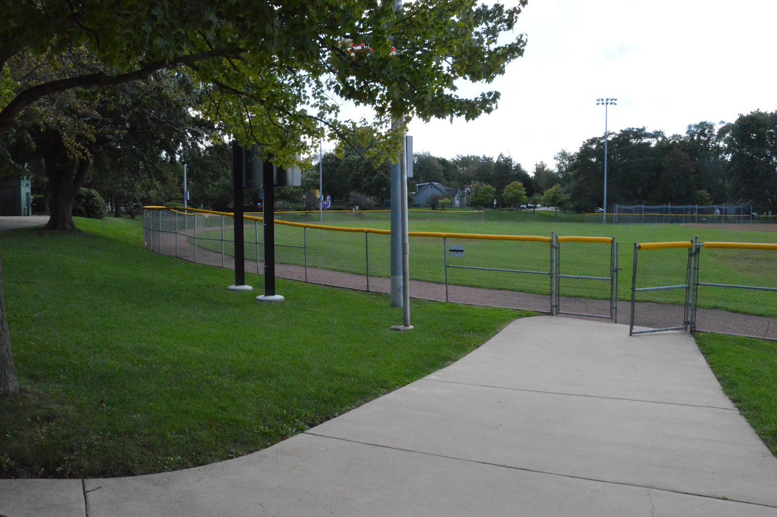
the ball park south of the house was the clay pit for the brick factory. The diamond was visibly lower than the surrounding land. I took a couple of photos to try to capture the slope of the land along the edges of the diamond.


I found myself parked in, so I had to kill some time. I walked down past home plate to take another photo to try to capture the fact that the diamond is in a pit. That is Gregg's House in the middle of the photo. A park district building is to the right of the house.

During the oral presentation, I was showed one of the bricks he made. I knew that the markings on a brick are important to brick collectors. So I went back in to get some close ups of the demonstration brick. Note that the S is backwards.
Image taken with permission of the Gregg House Museum

Image taken with permission of the Gregg House Museum

Image taken with permission of the Gregg House Museum