Of the nine truss spans, five of them are over flood plains.
 |
| Bred Davidson posted, cropped, May 3, 2022 The Florence IL. Bridge |
 |
| Kevin Stewart, Jul 2019 Single photo enhanced with easyHDR 3.14: Illinois River Bridge. |
 |
| Lisa Ruble posted Florence Bridge Pike County - Illinois River - Scott County March 2026 |
 |
| Jim Pisell posted Florence Bridge. Mike Yerion: Per my engineering school buddy, who worked bridges for IDoT, there were four of these type of bridges built over the Illinois. I grew up in the area. When I was a kid, mom and I would come here and get fish from the fish markets. I played and fished on MM 50, Montezuma Landing. As an adult, I did night patrols from Grafton to Meredosia doing Aids to Navigation inspections. Love this area and river. Richard Telford: Mike Yerion Hi Mike! The lift bridges on the Illinois River were Joe Page at Hardin, the Florence bridge, the Pekin Lift bridge which has been gone for years, and the Shippingsport bridge at LaSalle which also has been gone for many years. I inspected the Joe Page, the Florence and Shippingsport Bridges. My favorite one was the Joe Page because I thought it was in a scenic area. The lift span house was a unique place. |
 |
| Steve Stout commented on Jim's post |
Lisa Ruble posted five photos with the comment:
FLORENCE BRIDGE DEDICATED MAY 19TH 1930, OPENED TO TRAFFIC MAY 10TH 1930May 1930Pike County - Illinois River - Scott CountyLeRoy Johnson, superintendent of construction for the Illinois Steel Co. and who had superintended the two most important bridges in the state, LaSalle and Florence Bridges, described the vertical lift span on the new Florence Bridge, less than two weeks before the dedication of the bridge:"The bridge at Florence was designed by George F. Burch of the state highway department. It was built according to the requirements of the U.S. War Department, which has jurisdiction of all navigable streams. The department requires a clearance of sixty-five feet above high water in order to allow the passage of boats. The floor is of creosoted timbers with an asphalt wearing surface. The lift has a total weight of 350 tons and is counterbalanced at each end by concrete weights with a like tonnage. These weights are swung on two-inch steel cables of which there are thirty-two on the bridge. A line shaft runs the full length of the span. Small concrete blocks are used to add to the weight of the counterbalances, when necessary, and can be placed in wells at the top of the big weights. The powerhouse is located in the middle of the span. The bridge tender is so located in the steel frame house that he has full view of both the river and highway. When the boats whistle for the bridge to be lifted, the operator sounds an electrical warning gong at each end of the lift span. He then presses a button which lowers crossing gates at each end, and as the bridge lifts, steel barrier gates, another protection to highway traffic, are lowered. The bridge will be operated by two fifty horsepower motors, which are now in the process of installation. It w1ll require about minute to lift the span and clear the channel for the passage of boats."In September 1950, the state was taking bids for improvements for the Florence Bridge which included a new open steel floor. In April 1951, the Zimmerly Construction Company of Paris, Illinois, installed a new steel girder floor on the lift span of the Florence Bridge. During that time traffic was one way and flagmen were on duty twenty-four hours each day until the work was completed.Note: 790 square yards of creosoted lumber was used for the flooring of the lift span.1951 - The pilots like the bridge at Florence for at least three reasons:1. The span is directly over the channel. The man at the rudder says this circumstance is most unusual, "must've been an accident." One pilot observed "a lot of men study engineering for four or six years and then decide the channel is over next to some low water shack."2. The tenders "are on the ball. When you sound your whistle, you get action."3. The tenders always pitch down newspapers and magazines.A river cruise has some elements of excitement, but there are longer stretches of sheer monotony. The murky water looks pretty much the same all along the way and the willows along the bank don't vary much. Everybody has time on his hands, and any form of reading material is welcomed. Especially newspapers. The Florence tenders occasionally get a note of thanks for their contributions to the battle against boredom.A pilot aboard the Richard Moyles wrote: "Sometimes we become sort of desperate for a paper and always look forward to going under your bridge. We have radio news, but a good old paper, new news or a little stale, looks good to us. "Downstream I will hail you with the whistle- one long, two shorts. Upstream, one long, one short."In 1951, the average time for the lift span to be raised was seven minutes.Note: In the late 1920s and on into the 1930s the state of Illinois built four Strauss Vertical lift bridges across the Illinois River. Only two--the Florence Bridge and the Joe Page Bridge at Hardin are still in service. Shippingsport at La Salle and the bridge at Pekin have been replaced.
 |
| 1 |
 |
| 2 |
 |
| 3 |
 |
| 4 |
 |
| 5 |
 |
| Lisa Ruble posted Interior of the Florence Bridge machinery room in 1930. The machinery room is on the lift span of the Florence Bridge. Pike County - Illinois River - Scott County |
Lisa Ruble posted four photos with the comment:
Florence Bridge - Counterweight Sheaves were removed from the bridge following a 2012 mechanical problem and are shown in storage in this photo.Scott County - Illinois River - Pike CountyThe Florence Bridge was dedicated on May 19, 1930.Second and Last Photos: Tom WinkleI took the third photo.
 |
| 1 |
 |
| 2 |
 |
| 3 |
 |
| 4 |
Lisa Ruble posted four photos with the comment:
Florence Bridge
Opened in 1930
March 2026
Pike County - Illinois River - Scott County
 |
| 1 |
 |
| 2 |
 |
| 3 |
 |
| 4 |
 |
| Robin Kaye Lomelino posted Illinois River, Florence bridge! Florence Illinois, 08/01/25 Ronald R. Turner: Prior to the building of Interstate 72, U.S. Rt. 36 crossed the Illinois River on this bridge. Prior to 1972, U.S. Rt. 54 also was on this bridge. Sometime in the next few years, this bridge will be replaced with a new bridge that will be high enough over the river that a drawspan will not be needed. |
 |
| 1930 photo by Art Kistler from IDOT via BridgeHunter (HistoricBridges also has this photo.) |
 |
| Street View |
It is good to see that Illinois is doing at least some maintenance on a truss bridge.
 |
| Street View, Oct 2016 |
But maintenance expenditures will be stranded assets. IDOT completed a 3-year environmental impact study and plans on replacing this bridge with a UCEB (Ugly Concrete Eyesore Bridge) 300' south of this bridge in their FY21-26 funding cycle. IDOT says it will look similar to the Champ Clark Bridge. The Clark Bridge is just two lanes, but it does have wide shoulders. It will not only be high enough that it doesn't need a moveable span, it will be designed to more effectively avoid flooding. [wlds]
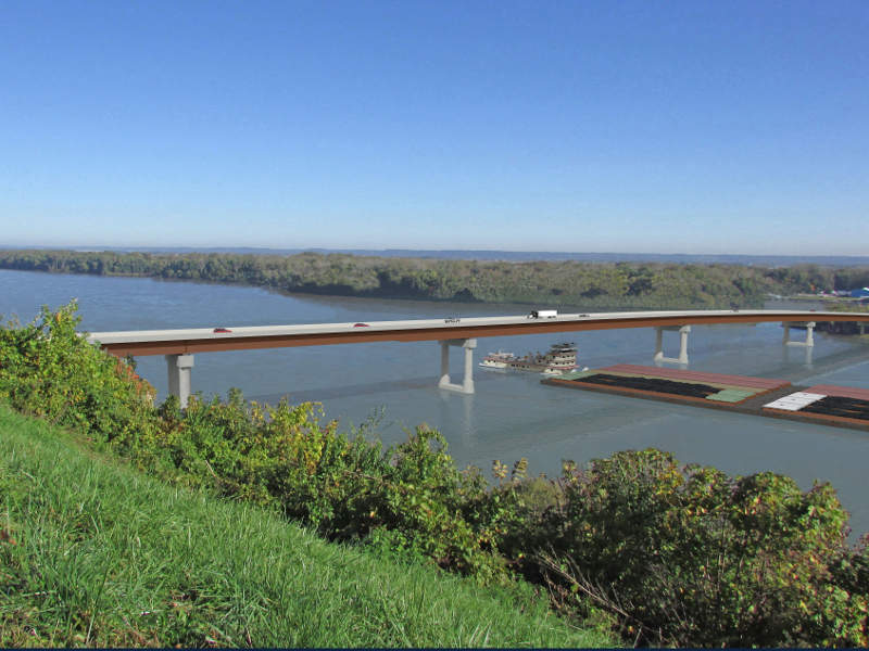 |
| IDOT via roadtraffic-technology |
 |
| FlorenceBridgeStudy |
Florence is not much more than a grain elevator. There is a stone quarry just a little north of this road.
 |
| Satellite |
Ed & Woodie's Tap is now permanently closed. This is another reminder that 2019 was a very wet year in the heart of the USA. However, it does appear to have opened again as the Riverbank. If the water was this far inland, it must have been real close to the bottom of the trusses.
 |
| Kiersten Herron, May 2019 |
And the flood plain extends beyond the truss spans that were built over land.
 |
| Apr 2013 photo by Jeremy Ruble via BridgeHunter |
Taking another look at a satellite image, the above view is of the east side and the hill in the foreground is a levee.
 |
| Satellite |
"The Florence bridge was refurbished in 1981, and refurbished again in 2004. In the 2004 project, the deck was replaced, the bridge was sandblasted and painted, the lift cables were replaced, a new operators house was built, and electrical work was performed. Update—the Florence Bridge was closed on June 28, 2012, when a routine inspection revealed a structural issue at the top of one of the lift towers. This caused one set of large pulleys at the top of the bridge to shift laterally. If the bridge were to remain in operation, additional damage would occur that would be much more difficult to repair. The bridge is expected to be closed at least 9 months while a repair strategy is developed. In the mean time, the lift span has been left in the open position to allow river navigation traffic to pass under the structure." [JohnWeeksIII] According to comments in BridgeHunter, the bridge was closed again in 2016 and 2019 because of allisions by barges.
 |
| Mar 2013 photo by Calvin K Lunny via BridgeHunter, License: Released into public domain [Calvin has uploaded several photos to Bridge Hunter that were taken from and of the control house during the 2013 repair of the sheave that shifted laterally in 2012.] |
Judy Goby Oxtoby posted three photos with the comment: "Joy riding on IL Rt 106…crossing the Illinois River on a wonderful old draw bridge."
Ronald R. Turner: The drawbridge at Florence, Illinois. Today, it is Illinois Routes 100 and 106 that cross the Illinois River on this bridge. Prior to the completion of what is now Interstate 72, this bridge carried U.S. Route 36 and Illinois Route 100 across the Illinois River. Back then, Illinois Route 106 ended at Winchester, Ilinois, where it intersected with U. S. 36.
A new bridge is supposed to be built at this location in a couple of years. Once that bridge is completed, this bridge will be removed.
Norman Schafer shared
 |
| 1 |
 |
| 2 |
 |
| 3 |
 |
| Lisa Ruble commented on Judy's post Interior of the Florence Bridge (Illinois River Bridge) machinery room in 1930. The bridge was Dedicated on May 19th 1930. The bridge is one of four Strauss Vertical lift bridges built in Illinois, two have been demolished and replaced. The machinery room is on the lift span of the Florence Bridge. Photo Credit: Art Kistler, IDOT Tender House |
 |
| Lisa Ruble commented on Judy's post [Lisa provided a ton of photos of this bridge and of some other bridge in the comments. She also posted photos of her "bucket list" bridges.] |
 |
| IDOT [Illinois is claiming that construction will begin in 2024, yet a comment says they have yet to buy any land.] |
 |
| 2:36 video |


