(
Satellite)
(Update: A lot more photos of the newer USACE lock are
here. Those notes also have some videos from tows going through the lock.)
The powerhouse and lock at the end of this extension were opened in 1907.
More about this photo later.
 |
| 20140614 0259 |
When the Chicago Sanitary & Ship Canal (CS&SC) opened in 1900, it terminated at
a control structure north of 9th Street at Lockport, IL.
There was a 160' bear trap gate in this gap to fine tune the flow of water out of the canal into the Des Plaines River to maintain the proper water level in the canal. That gate has been removed because the
powerhouse now provides the day-to-day control of the water level. The sluice gates are still intact in case flood waters need to be released from the canal.
There is about a 40' drop in the land between this control structure and
the confluence of the canal with the Des Plaines River just south of the
CN/EJ&E Bridge. This drop is why the I&M Canal had its first four locks between
just north of Division Street and
north of the CN/EJ&E tracks.
To take advantage of this 40' drop, the Metropolitan Water Reclamation District (MWRD), then known as the Chicago Sanitary District, made a canal down the slope by building concrete walls on both sides with earth fill on the sides. This 3D view shows the east dike.
And here is a view of the drop of the land along the west dike.
Now we have the context needed to explain the top photo. That photo was taken from the bus that was driving along the west wall to take us to a tour of the powerhouse. I knew we were driving along a high wall, so I was trying to get photos that showed the height. I also knew, from taking photos in the Rocky Mountains, that it is hard to show height from above. Here are the rest of the photos I took on this part of the trip.
On the trip back to the parking lot, I took a photo looking South when we were on the 9th Street Bridge to capture what I thought was a rather high level of the Des Plaines River. The blue on the left is the higher level of the canal.
Or maybe the river is always this high.
 |
| Street View, Oct 2019 |
I also got a view of nature taking over some sunken barges.
While taking some photos of a towboat, I caught a view that shows the canal level higher than the surrounding land. Of course, it is not as high at the 9th Street Bridge as it is at the powerhouse and lock.
It is worth noting that dikes were used at the original terminus of the CS&SC so that the base of the
control structure would be above the Des Plaines River to maximize the flow from the canal to the river during floods. The MWRD must have been really worried about being able to divert flood waters because, when the extended the canal in 1903, they added a
butterfly dam near the beginning of the extension. Note two contour lines coming close together near the end of the original canal, especially on the east side.
 |
| 1954 Joliet Quadrangle @ 1:24,000 |
Those two contour lines continue down to Division Street. I've read that the dikes were 15' tall at 9th Street.
 |
| 1954 Joliet Quadrangle @ 1:24,000 |
Starting at Division Street, more contour lines are added. That makes sense because the I&M Canal locks are along this stretch.
 |
| 1954 Joliet Quadrangle @ 1:24,000 |
Although I think the big pile of contour lines on the west side of the canal south of the powerhouse is a mistake.
 |
| 1954 Joliet Quadrangle @ 1:24,000 |
On the right of the photo below, we see the west wall of the
USACE lock. In the background, from right to left, is the tall, narrow gates for the
old 22' x 120' x 34' lock, the current control structure and the
powerhouse.
 |
MWRD posted
Construction of the Chicago Sanitary and Ship Canal (CSSC) extension near Lockport, Illinois, on March 26, 1904. When the CSSC was completed in 1900, it ended at the Controlling Works near Lockport. The Sanitary District of Chicago (now MWRD) built the extension to Joliet to allow for complete navigation from Lake Michigan to the Des Plaines River via the CSSC, effectively replacing the I&M Canal. The Lockport Powerhouse is located at the midpoint of the extension.
MWRD posted again |
 |
MWRD posted on Jan 3, 2023
Early stages of work on the Chicago Sanitary and Ship Canal (CSSC) extension near Lockport, Illinois, on April 14, 1904.
MWRD posted |
 |
MWRD posted on Apr 7, 2023
Excavation for the Chicago Sanitary and Ship Canal (CSSC) extension near Lockport, Illinois, on June 14, 1904. Construction of the CSSC was the largest earth-moving operation undertaken on the North American continent up to that time and was notable for training a generation of engineers, several of whom later worked on the Panama Canal. |
 |
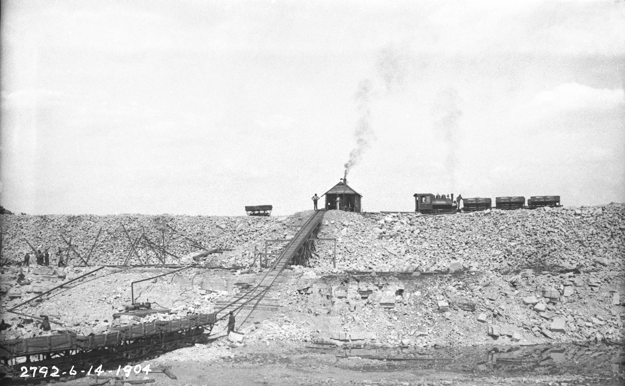
MWRD posted on Apr 20, 2022
Today's photo shows miscellaneous equipment and new train engines during construction of the Chicago Sanitary and Ship Canal (CSSC) extension in Lockport, Illinois, on June 14, 1904. |
 |
MWRD posted on Oct 10, 2022
Excavation for the Chicago Sanitary and Ship Canal extension near Lockport, Illinois, on June 14, 1904. |
 |
MWRD posted
Construction of the Chicago Sanitary and Ship Canal (CSSC) extension looking north from about 9th Street in Lockport, Illinois, on April 14, 1904.
Kelly Doyle: I'm over sixty years of age. This work [ TARP] started over 40 years ago.....what happened and how does this take SO LONG to complete? Dennis DeBruler: Kelly Doyle The tunnels have been done for a while. In terms of the reservoir, look at the size of the holes that they are digging. And the rate that they can dig is limited by how fast Vulcan can sell the rock. https://maps.app.goo.gl/jQVYt9c6GHSLVww97 |
 |
MWRD posted on Feb 16, 2023
Workers during the excavation for the Chicago Sanitary and Ship Canal extension on September 22, 1904. |
 |
MWRD posted
Workers pause for a photo while casting concrete blocks for the Lockport Powerhouse walls on October 25, 1905. |
 |
MWRD posted
A rock crushing plant is seen in this photo from October 25, 1905, reducing the size of excavated material during construction of the Chicago Sanitary and Ship Canal extension near Lockport. The four-mile extension was excavated by the MWRD between 1903 and 1907, and included the construction of the Lockport Powerhouse, dam and lock, which are located at the mid-point of the extension. The area features an elevation difference between the Chicago Sanitary and Ship Canal and the Des Plaines River of approximately 36 feet, which allows for the generation of hydroelectric power at the powerhouse.
MWRD posted on Feb 18, 2023 |
 |
MWRD posted
Laborers take a photo break during the construction of the Chicago Sanitary and Ship Canal (CSSC) extension on September 22, 1904. Splattered with drilling mud and posing next to compressed air rock drills, they were drilling holes for explosives during excavation of the four-mile extension, which began in 1903 and was completed in 1907. When the CSSC was completed in 1900, it ended at the Controlling Works near Lockport. The Sanitary District of Chicago (now MWRD) built the extension to Joliet to allow for complete navigation from Lake Michigan to the Des Plaines River via the CSSC, effectively replacing the I&M Canal. The Lockport Powerhouse is located at the midpoint of the extension.
|
 |
MWRD posted on Nov 22, 2022
Construction of the Chicago Sanitary and Ship Canal extension near Lockport, Illinois, on October 25, 1905. |
 |
MWRD posted
Excavation of the Chicago Sanitary and Ship Canal extension south of the Lockport Powerhouse in Lockport, Illinois, on October 25, 1905.
MWRD posted
Excavation of the Chicago Sanitary and Ship Canal extension south of the Lockport Powerhouse on October 25, 1905. |
 |
MWRD posted
A view to the south from a bridge at 9th Street in Lockport, Illinois, showing construction of the Chicago Sanitary and Ship Canal extension on November 9, 1905. |
 |
Dennis DeBruler commented on the MWRD post
As they worked their way south, they didn't have to dig as deep, but they had to build a higher embankment on the sides of the canal. |
 |
MWRD posted
A view of work on the extension for the Chicago Sanitary and Ship Canal on May 12, 1904. |
|
MWRD posted
A rock crushing plant is seen in this photo from October 25, 1905, reducing the size of excavated material during construction of the Chicago Sanitary and Ship Canal extension near Lockport. The four-mile extension was excavated by the MWRD between 1903 and 1907, and included the construction of the Lockport Powerhouse, dam and lock, which are located at the mid-point of the extension. The area features an elevation difference between the Chicago Sanitary and Ship Canal and the Des Plaines River of approximately 36 feet, which allows for the generation of hydroelectric power at the powerhouse. |
|
MWRD posted
A view to the south from a bridge at 9th Street in Lockport, Illinois, showing construction of the Chicago Sanitary and Ship Canal extension on November 9, 1905.
MWRD posted on Jun 28, 2022 |
 |
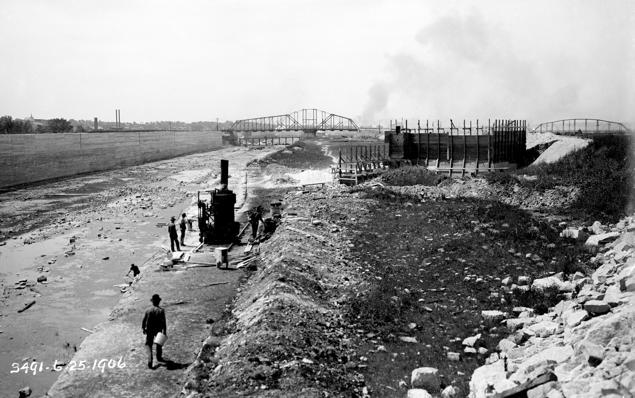
MWRD posted
Work on a levee for the foundation of a bridge abutment during the construction of the Chicago Sanitary and Ship Canal extension south of the Lockport Powerhouse on February 19, 1906. |
 |
MWRD posted
A steam shovel loads dump cars near Joliet on February 28, 1906, during excavation of the Chicago Sanitary and Ship Canal extension south of the Lockport Powerhouse.
MWRD posted on Dec 20, 2022
A steam shovel loads dump cars near Joliet, Illinois, on February 28, 1906, during excavation of the Chicago Sanitary and Ship Canal extension south of the Lockport Powerhouse. |
 |
MWRD
Construction of the Chicago Sanitary and Ship Canal extension near the Lockport Powerhouse on May 14, 1906. |
 |
MWRD posted
Construction of the Lockport extension of the Chicago Sanitary and Ship Canal on May 23, 1906.
Bradley Niven: I would love to hear the story of the Bear trap being completed and open ahead of the lock to rush the reversal ahead of the courts stopping them. |
 |
MWRD posted on Jun 7, 2023
Construction of the Chicago Sanitary and Ship Canal extension near the Lockport Powerhouse on May 14, 1906 |
|
Dennis DeBruler commented on the MWRD post
As they worked their way south, they didn't have to dig as deep, but they had to build a higher embankment on the sides of the canal. |
 |
MWRD posted
Construction of the Chicago Sanitary and Ship Canal extension near Lockport on June 1, 1906. |
 |
MWRD posted
A concrete mixer and wall construction for the Chicago Sanitary and Ship Canal (CSSC) extension in Lockport between 9th and 16th Streets on June 9, 1906 |
 |
MWRD posted
Excavation of the Chicago Sanitary and Ship Canal extension south of the Lockport Powerhouse on June 11, 1906. |
 |
MWRD posted
Construction of the Chicago Sanitary and Shipping Canal (CSSC) channel extension at Lockport, Illinois, looking south toward the area where the Butterfly Dam was eventually built on June 25, 1906.
Albert Bartkus: cool but I wish I could place this exactly. on google maps. is the butterfly dam what is the sluice gates before the lock going downstream? and the channel that goes to the power plant?
Dennis DeBruler: Albert Bartkus All traces of it appear to be gone:
https://www.google.com/maps/@41.5960878,-88.0652201,185m/data=!3m1!1e3?entry=ttu |
 |
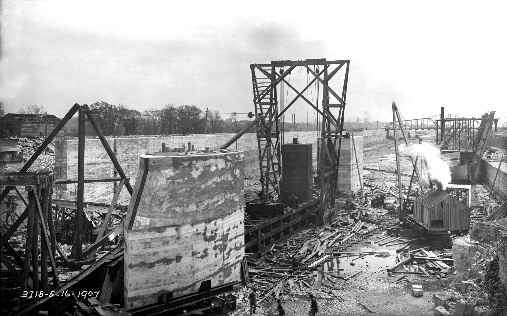
MWRD posted
Construction of the Chicago Sanitary and Ship Canal extension near Lockport, Illinois, on March 18, 1907. |
 |
MWRD posted on Nov 30, 2022
Workers repair a section of wall on the Chicago Sanitary and Ship Canal near 16th Street in Lockport, Illinois, on July 11, 1911. |