Showing posts with label rfGragg. Show all posts

Friday, June 19, 2020

1909 Kilbourn Dam and Milw Bridge on Wisconsin River in Wisconsin Dells, WI

(dam construction photo; Bridge HunterSatellite, I chose a wide angle to include the RR bridge)

This 1909 dam has a capacity of 10 MW. It was the biggest dam west of Niagara Falls. (The 142 MW Keokuk Powerhouse wasn't finished until 1913. Each of the 15 units in that dam could do 10 MW.) It is nearly 350' long and 55' high. "Kilbourn was the first major power-generating dam built on the Wisconsin River; later, more than two dozen others were built....The dam evened out water flow and raised water levels on the river, making some of the scenic spots amid the high sandstone cliffs accessible to tourists....Made of concrete, the Kilbourn Dam was the first permanent, power-generating dam on the Wisconsin River. Earlier dams, built of wood in the 1800s, were blown up by loggers." [madisonAlliantEnergy]

Roggy Gragg posted
The westbound Empire Builder departs Wisconsin Dells, WI and passes over the Wisconsin River. In the foreground is the historic Kilbourn dam.
Zooming in on the sluice gates.
Digitally Zoomed

The 1903 pin-connected Pratt truss replaced an 1877 Whipple truss, which replaced an 1856 Howe truss.
Street View
A steam loco crossing the RR bridge in 2004.

Clarissa Peterson Flickr, License: Creative Commons Attribution-NonCommercial-ShareAlike (CC BY-NC-SA)
[After the road deck was removed and extra bracing was added.]

Street View

Street View

WiscNews, ED LEGGE/Dells Events
[A lady was able to save herself in March 2017 by grabbing the cable until some fire fighters were able to rescue her. The cable and buoys had been installed just the previous July. I never did figure out which bridge she jumped off because WI-13+16 does not cross the river and Google Maps doesn't know about "Kilbourn Bridge."]

Wednesday, July 17, 2019

UP/C&NW North Avenue Yard

I saved a satellite image because most of the industry that used to be served by this yard, including interchange traffic with the now defunct Chicago Terminal Railroad, has been kicked out of the area by gentrification. I wonder if UP will keep this yard for just car storage. Or if they will tear up the tracks for property tax relief. The land is elevated, so if the tracks are torn up, it would join the many expensive vacant lots in Chicago.
Satellite

Edward Kwiatkowski posted
A Union Pacific Railroad EMD GP 15 diesel electric locomotive, and a former Chicago & Northwestern Railroad steel bay window caboose.
Chicago Illinois. July 2019.
Michael Bose I have seen this very locomotive quite often either crossing Irving Park Rd. at Six Corners, or Montrose at Mayfair, around midday. Usually with a couple of covered hoppers.
Dennis DeBruler Probably flour cars for Alpha Baking. It is one of the two industries that I know of that are still supported by this yard since Chicago Terminal Railroad had to abandoned the Milwaukee's former Chicago & Evanston tracks around Goose Island.
https://www.google.com/.../@41.9607066,-87.../data=!3m1!1e
Dennis DeBruler The other industry is the lower level of Blommer Chocolate. (NS serves the second level.)
https://industrialscenery.blogspot.com/.../blommer...
Dennis DeBruler I see that Sipi Metals has paved over its spur.
https://www.google.com/.../data=!3m1!1e3!4m5!3m4...
David Daruszka North Avenue Yard.[It looks like a railroad tower is photobombing the caboose.]
Street View, looking from the north side
The tracks in the foreground are the mainline. It is good that UP is storing some cars in the yard to highlight the yard tracks.
Street View, looking from the south side

Alpha Baking has three flour cars spotted at their building.  Since the section of this branch that went up from 40th Street Yard no longer exists, these cars would have to be shoved south from the Mayfair Junction with the Northwest line.
Satellite

The satellite at the beginning of these notes shows the gap between the mainline and the yard is bare. This 2011 Flickr shows that it used to have vegetation. Allan's comment on the Flickr photo:
Gosh, when I blew up this pic, it totally makes sense where this is now. You're slightly south of the Clybourn Metra stop, somewhere in the rail yard just south of that stop, and east of the Kennedy. The Morton Salt building totally gives this pic away. :)
As an exercise to learn more about Chicago and the C&NW I found the taller brown building that is to the left of Willis/Sears Tower in the 2011 Flickr photo. This satellite extract has that building in the lower-right corner. I added a red line to show the sight-line along the yard in the photo. It does catch the south end of the former Mortan Salt Co. warehouse.
Satellite
One thing I learned is why the black building along the Chicago River that had its nice river view skunked by the Trump Tower is no longer called the IBM Building. IBM has built a new building that is down in the financial district and closer to the commuter stations. The brown building is across the corner from it and Willis is a block south.

Satellite
This satellite image has to be rather old. I see three hopper cars parked by the building. I remember Morton Salt closed this warehouse facility a few years ago. So I doubt if there have been hopper cars parked at the building for a while now.

It looks like Sipi Metals has paved over its spur.
Satellite


Around 5:54 in this video, the camera rolls past this yard. The 1988 date is old enough that the yard is rather full and traffic is moving right along on the Kennedy Expressway.

d.w.davidson Flickr of three switchers parked at the south end
Carlos Ferran posted, used with permission
UP 1430 leads YNO68 north to North Ave. Yard with a generous count of 6 high cube boxcars from Tribune. Taken from high above River West.
Jan 2, 2020.

Carlos Ferran posted
Looking back from the beginning of the month, I took to the sky for a shot of YNO68 returning to North Avenue from Tribune with a total of 6 high cubes. Not bad, considering we're in 2020 and print is on the down slope. Sometimes the best way to admire UP's hold on downtown service is to look from above. However, downtown freight wont last forever, so shoot it if you can.
-----------------
YNO68
UP 1430
1/2/2020

David Dupuis posted
UP YNO68 switches out the Tribune, located off of Grand Ave in Chicago, IL. Taken today, 4/23/2020.
Daniel Rappoport Interesting that they now use 60' hi cubes, I miss the old 50' WC and Ontario Northland cars.
Terry L. Hunt I remember those paper boxes being on the tail end of GTW 393 to Proviso. They always had a subtle way of letting you know they were back there. Came in to Proviso and S/O the head end for Janesville's in 4 yard. Yarded the balance in 9 yard putting the paper boxes right where they could be grabbed to go to the Tribune.
Taylor Rich Terry L. Hunt PSR, when it was simply known as doing your job well.
Aaron Sims Chicago switching. love it.didn't know it still exist.

Erik Coleman Would that be the old passenger mains to Wells St station over to the left?
Matt McClure Erik Coleman These tracks lead to the former "low line" that [once] led all the way onto Navy Pier. Still busy to Blommer Chocolate.

As of Jan 2024:
Mark Llanuza posted
U.P job YPR60B that comes from the old CNW Des Plaines IL Coach yard near Deval and runs southeast to North Ave and switches Chicago Tribune. On this day he is switching box cars today at the Tribune company in the rain with CNW crew engineer Jeff Kaufmam and CNW conductor Ricky Davidson .This facility will soon be the next Bailey's Casino at the former Tribune printing company.
Steve Bayorgeon: Other than the chocolate factory, does it switch anything else?
Mark Llanuza: Steve Bayorgeon for now the Tribune and Chocolate its last business left downtown .They switch Alpha baking company near Mayfair/
Peter Totzke: Sometimes they do Sysco at the DesPlaines coach yard where they get the cars for the industries downtown and Alpha bakery.

Doug Kaniuk posted five photos with the comment: "3/13/2020, Cragin Industrial lead, near Milwaukee Ave, Chicago, IL, local freight."
Doug Kaniuk Paul Musselman was always in use, served the Alpha bakery (at Armitage).
Bob Jungmann Doug Kaniuk Formerly the "Mary Ann Baking company" that at one time was the supplier for ALL of McDonalds !! That track used to run across the back side of Hermosa Park---remember it very well. Once as a young kid (early 50's Korean war time) a train full of passenger cars full of USAF members---windows up and arms out the windows, went by the park---probably headed to the USAF base by O'Hare from the NW line to Des Plaines and then down along the line that goes S. from Des Plaines to the airport.
Tim Sasse Looks like cars for all the industries served out of North Ave Yard.
Hopper for Alpha Baking
CP boxcars of newsprint for the Chicago Tribune.

A tank car for the lower level at Blommer's Chocolate.

Michael Bose This turn once upon a time, not that long ago, handled bulkhead flatcars full of lumber, plywood and drywall/sheet rock until Mayfair Lumber closed down.
Doug Kaniuk also, Hines lumber.
Karl Beetschen and Miller Bro’s. Lumber.
1

2

3

4

5
Paul Musselman And a caboose, even!Mark Frankel With CNW markings!
Doug commented on his post
Must be a different crew, usually just the engine and hopper would go down the line. attached picture from 2010

Dennis DeBruler commented on Doug's post
Dennis DeBruler A spot that needs the leaves off the trees.
https://www.google.com/.../data=!3m6!1e1!3m4...

A video of a train going to Alpha Bakery. The comments indicate that Job 68 serves the bakery, Chicago Tribune (boxcars) and the lower level of Blommers Chocolate (tank cars).
Doug also posted.
Matthew Gibbons I have seen that caboose recently what’s the story behind it.
Brandon McShane It's now based in North Avenue Yard for Job 68.
Doug Kaniuk Job 68 out of North Ave Yard served Morton Salt, Chicago Tribune and the lower track at Blommer (corn syrup & cocoa beans). They also serve Alpha Bakery on the Craigin Line.

Not only has UP closed the hump in Proviso Yard, it seems they have closed this yard completely.
Tyson Park commented on a post:
Normally both levels of Blommer were switched out by the North Avenue-based job which ended last month. It is now switched all the way out of Proviso along with the Tribune Freedom Center. I wonder if UP has moved the operations from the Harvard Subdivision to the Geneva one? Either way to access the lower level Blommer spur and the Tribune they would have to use the ladder tracks at the west end of Ogilvie Station to go from the Geneva to the Harvard subdivision which is what the North Avenue-based job did in reverse to access the upper level Blommer spur.
Some comments on this post explains how UP serves its few remaining industries from Proviso Yard.
Dave Zeman posted
YPR60 makes a run to the Chicago Tribune with UPY 815 and a former-CNW caboose bringing up the rear.
6/22/2021
[The grass used to be a multi-track holding yard for the Chicago Tribune.]
Matthew Schoell: Anyone know who the centerbeam's for?
Dave Zeman: Matthew Schoell Heller Lumber in Arlington Heights
[At first, I didn't even see the spur that goes into Heller Lumber.]
Sam Dickey: They got the crummy back!
Ken Walker: That line also feeds the street level trans loading for Blommer Chocolate. That’s where those tank cars are spotted and that siding holds the overflow.
Tim Sasse
I believe YPR60 runs Sun, Wed round trip from Proviso to Waukegan and back.
Mon, Thus round trip from Proviso to the upper level of Blommers on the West Line and back.
Tue, Fri round trip from Proviso to Des Plaines and down to Northwest Line (also to Hellers and Alpha Baking on the Cragin Spur) down to the Tribune/Blommers lower level and back.
 
Robby Gragg Flickr
Days are numbered
UP GP38-2 815 arrives at the Chicago Tribune with YPR60. The Tribune will wrap up operations here in June to make way for a casino. Between that and Blommer chocolate closing UP will soon no longer have any customers in downtown Chicago. Chicago, IL

Dec 2024: The Freedom Center is being torn down to make room for a casino. That is in the news because a wall collapsed into the river causing a bunch of white stuff to float on the river. It turns out, the white stuff was perlite. It looks like they have learned their lesson and now have a barge parked next to the demolition activity to catch any debris spills.
MWRD posted
📣 ICYMI Block Club Chicago: A wall collapsed Saturday at the site of the new casino, causing discharge of non-contaminating perlite into the water, according to the MWRD. Cleanup was completed Sunday.
The discharge of debris is believed to have been caused by a wall collapsing into the river during the demolition process, said Allison Fore, spokesperson for the Metropolitan Water Reclamation District of Greater Chicago. The site was formerly home to the Chicago Tribune’s Freedom Center.
🌊 MWRD/News: 
Credits: Block Club Chicago
Frank Giovetti: perlite is basically glass that can float on water(until it gets waterlogged)

(Facebooked)


Monday, June 10, 2019

EJ&E Well Pump House

(Satellite)

Steve Kraus posted
Can anyone tell me about this curious building along the CN/EJ&E in Frankfort, IL (between control points Frank and Fort!)? Hoped to get it with a train but ATCS showed nothing coming soon. Photo taken yesterday. [6/6/2019]
Jacob Metzger It’s a EJ&E water pumping house from ages ago, from what I’ve always been told.
Steve Kraus Ah. Must have been a water tower near there.
.Unfortunately, Facebook deleted my comment, so I have to type it again here.

I concur that it is a pump house. The gantry above the rectangle hole in the roof is to pull sections of the well pipe when they need to clean the screen at the bottom of the well.

In this 1939 photo, Oak Street, which is near the left side of the photo, crossed the tracks.
1939 Aerial Photo from ILHAP
I scaled this satellite image so that the distance between Oak Street and Center Road would be about the same.
Satellite
In this photo I added a red rectangle around the pump house and yellow rectangles around possibilities for water towers.
Above aerial photo plus Paint
Of all of the buildings that the EJ&E had here, why is this the only one still standing? Is it now one of the wells that Frankfort Village uses for their water supply?

Thomas Dyrek posted
The Frankfort steam pump house as it appeared a few days ago. When was it built and when was the adjacent depot removed? Thomas Dyrek photo.

Robby Gragg posted
Just a few weeks after the CN takeover, a trio of J SD38-2s lead State Line loads East past the old pump house in Frankfort, IL. 2/10/09
Dennis DeBruler: 41°29'32.0"N 87°50'57.4"W

Saturday, March 16, 2019

Flood of 2019: some UP and CP routes are closed, BNSF also

The heavy flooding was aggravated by a bomb cyclone.

The CP Turkey river bridge outage, detour and rebuild has been moved to its own post.


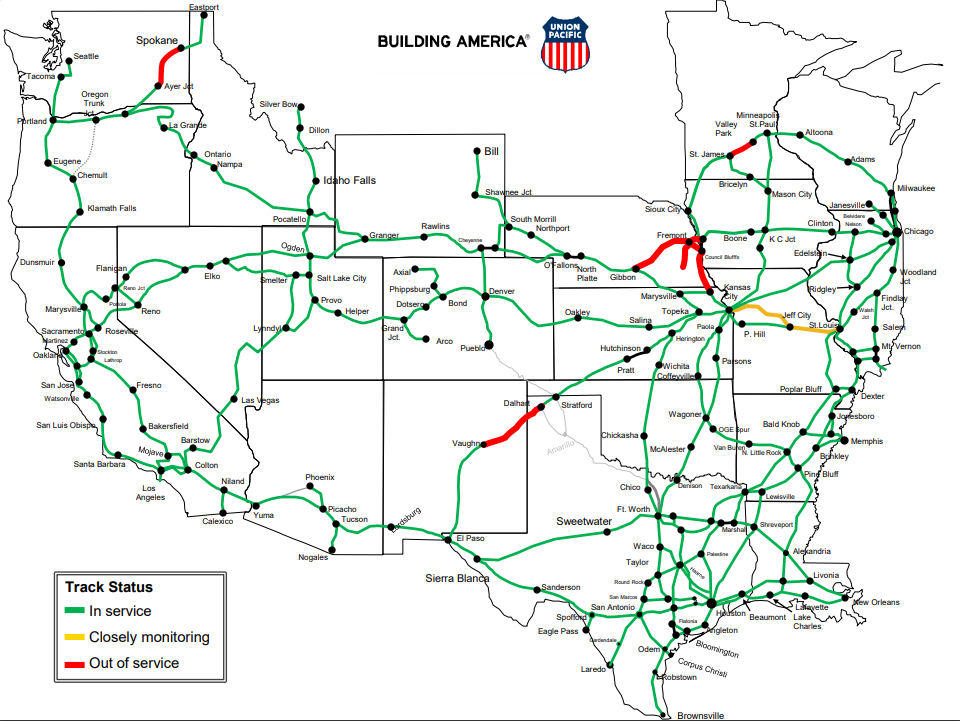
UP outage map accessed 10:09am, 3/16/2019. 


UP
I accessed the map again on 3/21, and it is the same except the Vaughn-Dalhart segment is back in service.
BNSF1
When I noticed that the above map was part of a "ServiceAdvisory" dated 3/18/2019, I looked for a more recent map.
BSNF3, accessed 3/24/2019
UP has outages because of wind as well as water:
[DeBruler]

This UP route through Logan, IA, is not the mainline.
Gary Felters posted two photos.
Dan Hodgson It's Logan by the cemetery
Shane Nixon Where are the trains detouring?
Gene Kracht Running some on the Spine.
I spent a while looking at a satellite map trying to find this location. But I couldn't find a cemetery nor match up the curves and trees with the satellite image. And I don't know where the Spine is. I assume UP has these double tracks, and CN has the single-track route through town.
1
2
But Columbus, NE, is on the original UP transcontinental mainline.
Ty Hansen's post
Columbus, NE
Harry Henderson The bridge, which is an old abandoned CNW railroad bridge, seems to have stopped the ice flow. But all this weather and such does suck.
Ty Hansen Harry Henderson yeah. Losing bridges left and right here in Nebraska.
[I disagree with Harry's comment. The bridge looks like it is on the original transcontinental route to me.]
If you watch the video [Sorry, the URL Facebook gives me doesn't work. You will have to dig through the post to find the video.], the river is not only out of its banks, the river is swiftly flowing over land that is normally dry.
Screenshot @ -0:07 from Mike Moffitts comment on Ty's post
[The video shows a fast flow of water through this intersection. I asked for the names of the streets for that intersection, but nobody answered.]

Joe Piper posted
Columbus, Nebraska
[The trees at the bottom are along the normal river bank of the Platte River.]

Satellite
UP's mainline is the track across the top of this image.

Sandra Oliver shared
Caden SilveraydoMan Wemhoff to Nebraska through the lens
Rails are impassable in Columbus , Ne unbelievable what water can do to somthing allowing 100s of tons pass it weekly
[Another example where there should have been an approach span over a flood plain rather than running the embankment all the way to the river's banks. It looks like the river widened itself on the other side of the bridge was well. I spent some time looking at a satellite image, but I could not find a bridge of this length in the Columbus, NE area.]
Ingraham
I normally avoid profile videos, but this video shows how bad the UP mainline is west of Columbus, NE. Significant stretches are still under water. And there are washouts. But I was surprised by the amount of debris left on top of the tracks in some places.

The Farmer's Life posted
Stranded cattle in North Bend, NE.
[North Bend is another town along the UP mainline.]
Andrew Tuttle shared
Marc Mcclure Old DeBruce Grain. Flooded the year it was built.Jay Lyon About a mile and a half from the river?
https://www.google.com/.../data=!3m1!1e3!4m5!3m4...
J Pete Hedgpeth West of Rock Port would be PHELPS CITY. Located between Langdon and Watson on the BHSF St. Joe, MO----P Junc line.

In North Bend, NE, the waters are lapping at the rails.
Screenshot
In fact, to the West, the water appears to be over the tracks.
Screenshot
Even if the water is not over the rails, the water high up on the embankment sides can cause derailments because it softens the earth. BNSF dramatically demonstrated this danger in Doon, IA on June 22, 2018 when they derailed tank cars and dumped oil into the flood waters.

UP's mainline also got damaged in Arlington, NE.
Boot Burnie posted
UP main Nebraska Floods
Scott Walters I work in KC we have an extra 26 trains a day being rerouted through here


I added BNSF to the title.
James Kissack shared
John Smith Kiss those traction motors goodbye!!
Greg Mas 250k each
Donald Klecan Nebraska. Outside Fremont if I remember correctly. Whole states a mess right now.
Vince Davis As long as there is no power to them, no problem... [Although it is ta radition in these MoW groups to be facetious. Like commenting on a wreck that "it will buff out." I don't know if Vince is kidding or not.]

Glen Schiffer posted
William Styskal It's a westbound sitting past sand crossing by the somewhat evacuated trucking company yard at Oreapolis by Plattsmouth.
John McCool Short circuit ground in the tractor motors!

Robert Leamont posted
Third shift at the Galesburg, IL Diesel shop.
Note that the far Tier 4 locomotive with the iron hand hanging back by its compressor room is the 3778, which is the lead locomotive that was in the viral picture of the BNSF sand train that was sitting in flood water in Nebraska recently.
Dennis DeBruler I read that a traction motor cost $250,000. Did all six have to be replaced?

William Styskal commented on Glen's post

Braytin Friedman commented on a post that has comments about how the detoured trains are being rerouted through Illinois.
[The comments are two techinical for me to understand. I don't know the current subdivision name of UP and BNSF in Illinois.]
[Update: this article identifies this photo as March 17, 2019 in Plattsmouth, NE. "Water flowed over and through levees...Many of the damaged homes are wet up to the roof line and likely ruined."]
Marc Dufour shared
Nothing like a nice, soothing foot bath…
Mit Benz posted
Allan Love Jr. Oreapolis.
Josh Ośmiałowski Hey look at that signal bungalow! The risers added to keep it above the flood plain worked!
[This looks like a different view of the three locos above.]

Alex Mendoza posted
BNSF Railroad near Cedar Creek, Nebraska, along Platte River
Talk about building on a flood plain. The BNSF is close to the Platte River on both sides of Cedar Creek.
Satellite


Screenshot
[It is worth playing the video to see how fast the Platt River is flowing at South Bend, NE]
BNSF2, accessed 3/24/19
BNSF Flood Recovery, accessed 3/24/19
Michael Matalis posted
Years ago (like the 70's) I visited Pacific Junction with a friend and remember little of it except that it was a big name for a small town. I wish the residents the best in what has to be very difficult times.
Steve Smedley updated
On assignment to cover flooding in Western Iowa and Nebraska for TRAINS Magazine Newswire. This is the main entrance into the evacuated town of Pacific Junction, Iowa. The Missouri River had a levee fail, which flooded the town and BNSF Creston Sub, at right, along with the Council Bluffs Sub. Depressing looks like a bomb went off. Steve Smedley
Christian Goepel The damage to people’s lives, communities, and transportation infrastructure is astonishing in western Iowa as well as across eastern Nebraska and eastern South Dakota. I’ve been traveling the broader three-state region (including a stop in Pacific Junction) for the last four days. Glad you’re covering it, too.

Trains, Steve Smedley
Flooding of the Platte River, south of Omaha, Neb., has destroyed spans of BNSF Railway's Omaha Subdivision, along with the Union Pacific's Fall City Subdivision. On Tuesday morning, a Union Pacific crane was working on removing a log jam on the upstream side of the bridge.
[Stellite, UP is on the west side]
Some more of Steve Smedley's photos are in this article.


Mar 18 Update:
Historic flooding is causing huge headaches for both freight and passenger railroads in Nebraska and surrounding states.
BNSF Railway reopened its Alliance-to-Lincoln line Sunday night after it had been shut down for several days because of flooding in areas between Ravenna and Hazard and near Broken Bow. BNSF spokesman Andy Williams said the line closed at Broken Bow on Wednesday and at Ravenna on Thursday. Williams said there are other BNSF rail lines that are still affected, although he did not specify which ones.
Union Pacific also has seen several of its routes impacted by flooding, said Raquel Espinoza, a spokeswoman for the Omaha-based railroad. Routes that are out of service because of flooding include Fremont to Grand Island and Fremont to Missouri Valley, Iowa; Valley to Lincoln; and Council Bluffs, Iowa, to Kansas City, Kansas, a route that runs partially on the Nebraska side of the Missouri River. The Grand Island Independent also reported that a half dozen U.P. trains are parked at Central City and Clarks because they are unable to continue on to their destinations. The company said in a bulletin to customers that because the flooding is so widespread, it has "very limited reroute capacity."
The track problems for BNSF and U.P. also are affecting Amtrak.
[LincolnJournalStar]


Ryan Christensen shared
This is the railroad in Nebraska (NCRC) I used to work for. I quit to join CN in Wisconsin, and am looking back wondering how my friends are going to fare.
Jory Knowlton posted three photos with the comment: "Railroad tracks leading West out of Monroe. The AWESOME Power of Water."
Dennis Frances Dommer It looks like the railroad has been abandoned for years.
Jory Knowlton Dennis Frances Dommer it has not. However, yes it looks that way. Lots of Sand, ethanol and grain gets shipped through this Nebraska Central line.
[The bridge span has been shoved off its bents.]
1

2

3
BNSF reports that much of its mainline trackage in South Dakota is out of service, along with its main line from Alliance to Omaha, Neb.
Union Pacific specifically calls out service disruptions on its Omaha, Blair, Columbus, Lincoln, and Falls City subdivision, mostly near the Missouri River in Iowa and Nebraska. A full UP embargoed line list is online
The National Weather Service has extended flood warnings for Omaha through March 23; though Monday for Lincoln, Neb. Elsewhere, the weather service has posted flood warnings for St. Louis, on the Mississippi River until further notice; for Cedar Rapids, Iowa, until March 23; and Memphis through March 31.

Candadian Pacific and BNSF share this route.
Screenshot @ -1:14
Elle Kay
I have never seen a train go through water like this. This is downtown Davenport, IA. I was up in the sky bridge checking out the Mississippi River flooding.
[I don't think too many other people have seen a train go through this much water either. They risk burning out traction motors at $250,000 each.]
The above video is from the sky bridge, the photo below shows the sky bridge.
Trains, Steve Smedley
Floodwaters from the Mississippi River are over the riverfront trackage for three blocks between Harrison and Perry streets. Trains were operating at walking speed through the flooded track, with CP track inspectors standing on both sides of three train movements on Saturday evening monitoring movements.
[The article says it is hosting BNSF detours between Davenport and Camanche, IA.]
Robby Gragg's comment on a Facebook posting
Jeff Delhaye Probably not 'isolated" as that would remove throttle response, but notched up with "generator field" turned off, to turn off the electricity to the traction motors, but let the traction motor blowers work harder.

Erik Rasmussen caught a BNSF local creating a rather big "bow wave" with another train on the Government Bridge. The comments explain that an engine in the rear is what is actually moving the train because the lead units are "isolated."
Posted by Robert Jordan on March 25, 2019 
http://trn.trains.com/railroads/ask-trains/2011/08/isolating-locomotives "main generator and electrical system for propulsion are disconnected."
Posted by Erik Rasmussen on March 25, 2019 
FSWood - the lead locomotives were isloated electrically and were not providing any power to pull the train.


Posted by mmi16 on March 25, 2019 
Hope the 720 has the traction motor blowers going to minimize water entering the traction motors!


Posted by Dana M. on March 25, 2019 
Fascinating photo and a great capture Erik! However - I wonder if the Conductor had to get off and flag the crossings since the gates were malfunctioning?! LOL! Now THAT would truly be a miserable "mandate" to have to flag the crossings! Talk about ending up with two "soakers" of footwear that would be uncomfortable to wear the rest of the day!


Posted by pitty on March 25, 2019 
I seen a UTube video with a CPR loco & DPU on the end, didnt have as much "bow wave" as this unit, they had CPR maintenance personal at the crossing gates, makes sense they would isolate the drive motors, must recheck UTube 2 C if I can make out if they are "off line" however I now noted the train did stop after the lead got thru the deep stuff.

Joe Dockrill shared
[I assume this is also on the riverside tracks in Davenport.]
Patrick McNamara RULES prohibit operating thru water more than three inches above the rails. Only a fucking idiot or a company "official" would be stupid enough to operate thru this.Nathan Thompson https://www.kwqc.com/.../Floodwater-does-not-stop-train... "A spokesman says whenever water reaches the top of the wheels, track inspections are conducted after each train goes by." [The TOP of the wheels?]
Kent Helbel post
Larry van Dyk I've seem it done, but you coast through the spot, generator field off, and throttle five to keep the motors dry.Adamski Choochalot Kent Helbel I've been through water 1 foot above the rail head, no ground relays!. Win!Craig Shaw Newer Traction motors have more clearance.Andrew Beeman Benjamin Ludwig we’ve been beating the same dead horse for days now. Gcor says anything over 3 inches over the rail is reduced to 5mph, anything more it must be monitored by a mechanical department.Mike Trentman Lots of wheel sets to change out for submerged bearings..Kent Helbel Mike Trentman my electrician friend saying that the motors are sealed. IDKMike Trentman Kent Helbel The roller bearings on freight cars have to be changed out if they are submerged. We changed 80 cars out last spring. all four wheel sets on each car.
TV6 View from Sky Bridge


As of Apr 9, 2019
FreightWaves
BNSF RAILROAD CREWS REPLENISHING BALLAST ONTO TRACKS DAMAGED BY FLOODING NEAR LA PLATTE, NEBRASKA. (PHOTO: BNSF)
FreightWaves

FreightWaves

Nebraska was bad by March 18, 2019: "the Nebraska DOT had determined 11 flood-damaged bridges would need to be replaced, and more than 200 miles of roadway repaired, according to the Omaha World-Herald....The floods hit a multi-state region in the Great Plains and Midwest fast and hard after a “bomb cyclone” dumped snow on an already frozen region last week and then swept in rain and warmer temperatures, quickly melting ice and packed snow. Newly released waters swelled northern rivers to historic heights, breaching about 200 miles of levees in four states. A map of road closures in Nebraska on the 511 travel information website brings the dramatic impact of the flooding into sharp relief, with more local roads and state highways closed than open in the eastern half of the state. Interstate 80 remains open, but many exits aren’t usable....The downstream impact on truckers and railroads has yet to be assessed, but the biggest blow may be to the region’s farming and livestock industries. The floods, which struck during calving season, caused widespread damage to cattle ranchers, including the loss of animals and the cost of moving and rescuing cattle. Flood waters left giant chunks of ice in farm fields." [JOC (countware of 5/month)]

I wonder what this normally looks like in September. Is all of this road construction still repairing flood damage?
511
I poked a few "dots" and discovered that US-136 is still [Sep 19, 2019] closed in both directions at the Missouri River.