Friday, March 31, 2023

1933 622.5mw Rock Island Lock and Dam on the Columbia River

(Satellite)

Street View, Jun 2019

HistoryLink, ca. 2010 Courtesy Chelan County Public Utility District
Author: Phil Dougherty, License: Attribution-NonCommercial-NoDerivs (CC BY-NC-ND 3.0)
"It is the first dam built on the Columbia River."
 
HistoryLink, Courtesy Great Northern Railway Historical Society
Rock Island without dam, pre-1933

cbr
First Powerhouse Nameplate capacity: 
   1933: 3 @ 20.7 MW, 1 @ 15 MW,
   1953: 6 @ 22.5, 
             212 MW total
Second Powerhouse Nameplate capacity: 1979: 8 @ 51.3 MW, 410.4 MW total
Total Nameplate capacity: 622.5 MW total
Peak capacity: 660 MW total

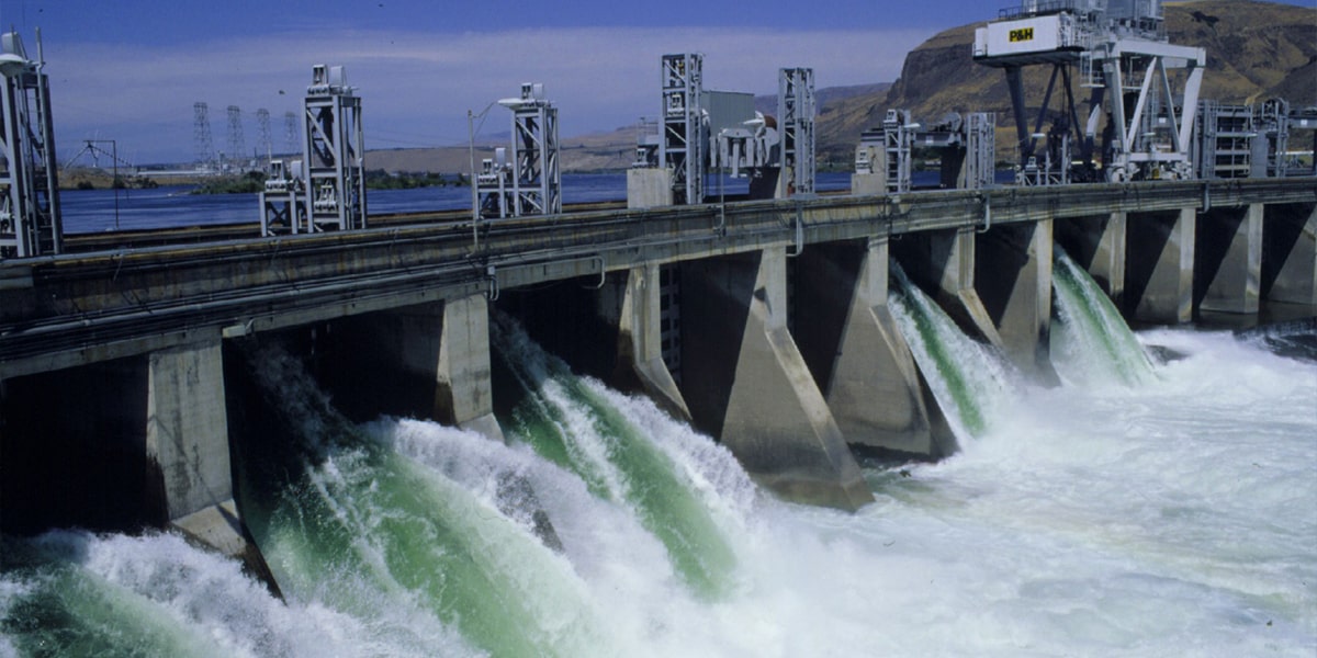
VisitWenatchee
"Dam contains 31 spillway gates."
The 1953 expansion supported Alcoa.

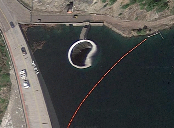
It uses sluice gates.
0:19 video @ 0:00, Logan Cleek, Jun 2020

HistoryLink, ca. 1960 Courtesy University of Oregon
Author: Phil Dougherty, License: Attribution-NonCommercial-NoDerivs (CC BY-NC-ND 3.0)
[A view before the second powerhouse was built.]
"The dam measures 3,800 feet long and has 32 spillway gates. Despite early talk that it would provide irrigation to the area, the dam's sole purpose is to generate electricity. It was originally built with two fish ladders, one located on each end of the dam. Concerns over insufficient fish migration through the ladders led to the construction of a third fish ladder through one of the center spillways in 1936, leaving 31 operating spillway gates."
 
1 of 25 photos of other subjects posted by Scott Butner
Order here: https://scottbutnerphotography.squarespace.com/readytohang-wall-art/p/rock-island-dam

The first powerhouse was on the east side.
1986 Rock Island Dam Quad @ 24,000

wsu, cropped
"The development of fisheries along the Columbia has a long and varied history.  Even before the advent of the white man, some 50,000 persons made the salmon a substantial part of their daily diet, taking an estimated 18 million pounds in their annual catch. The first recorded commercial fishing operations involving export of Columbia River salmon occurred in 1829, when Captain John Dominus of the ship Owyhee salted down 58 barrels for export shipping.  The first canning plant was established on the Columbia at Eagle Cliff, Washington, by the firm of Hapgood, Hume and Co., which put up 4,000 cases of salmon in 1866.  By 1883 some 39 canneries were in operation. 'Since 1866 the river has produced almost 2 1/4 billion pounds of salmon, or a value close to a billion dollars.'  On Dec. 29, 1938 the U.S.B.R. awarded a contract for 8 specially constructed tank trucks to be used for hauling the trapped fish from Rock Island Dam to the Leavenworth holding ponds, to the Kenworth Motor Truck Corp. of Seattle for $59,041.12."

When I first looked at a satellite image, I wondered why the dam was built on a wide part of the river. The above two aerial photos shows that they widened the river to make room for the second powerhouse.
3D Satellite

Tyler Hilliard commented on a post
A look at the operating ring and wicket gate arms on the downstream side of the powerhouse.
[Other comments indicate that it uses horizontal Kaplan turbines in the second powerhouse and vertical Kaplan turbines in the first powerhouse.]

May Moon posted
Rock Island Dam under construction. It was completed in 1933.
Dennis King: Greg Summers Hydroelectric development of the Columbia River in the United States began with the construction of Rock Island Dam, completed in 1932. A year later, the United States government, through the United States Army Corps of Engineers began construction of Bonneville Dam, followed by Grand Coulee Dam in 1934. Bonneville first power 1938, Grand Coulee Dam 1941.
Mike Kluth shared
From the Wenatchee Valley Facebook group.

Tyler Hilliard provided four photos along with the comment: "Currently doing rehab on powerhouse 2 that was completed in 1979. First horizontal bulb units in the nation, and the largest in the world when installed."
1

2

3

4


Thursday, March 30, 2023

1913 Cedar Hill Bridge over Animas River

(Bridge Hunter broke Mar 22, 2023; Historic Bridges; Satellite)

safe_image for Historic Cedar Hill bridge near Aztec will be renovated, David Edward Albright/Durango Herald
“The Cedar Hill Bridge is an extremely rare surviving example of a  pin‐connected highway truss bridge in New Mexico,” according to Bach  Steel’s scope of work and repair estimate. "Located in Cedar Hill, east of Aztec [New Mexico], the bridge was built in 1913,  according to San Juan Historical Society. It crosses the Animas River  and connects County Road 2380. Once the project is complete, the bridge  will become part of a 2-mile walking trail along the river."
The cost is $611,333.35.
"San Juan County Public Works Director Nick Porell...said the bridge was, “purchased from a catalog. I guess at the time you could purchase a bridge from the Montgomery Ward Catalog.”...The bridge was closed to vehicle traffic in the 1990s, but it remained open to pedestrian traffic until 2017, when it was determined to be too dangerous."

"The bridge is also significant for its lack of alteration, and even more so for its very remarkable lack of deterioration in its steel." A dry climate and no need to salt the roads probably helps prevent rusting. In fact, it has never been painted. [HistoricBridges]
Immediately west and parallel to the bridge is an irrigation flume which carries water over the Animas River. This flume structure is a pin-connected truss composed of members that are similar to those used in the highway bridge, but it has a significantly different overall configuration and appearance because it was purposely designed to serve as a flume. The flume itself is quite unusual and may have individual historic significance. It also compliments the architectural appearance of the highway truss bridge. [HistoricBridges]
The plume's truss is not rust free. HistoricBridges also identifies this bridge as a pin-connected truss.
Mani (Mani), May 2016


Wednesday, March 29, 2023

1869 Trail/B&O Bollman Bridge over Little Patuxent River at Savage, MD


(Bridge Hunter broke Mar 22, 2023; Historic Bridges; HAER Satellite, 156 photos)

HOrailroad has a lot of photos of the bridge to help people model it.

"The early B&O railroad started by using Howard County granite to stabilize track beds and build bridge abutments that created the first commercial granite uses in the County.  The Woodstock granite quarries were prominently used in the early 1830s to support the B&O and the same promise was held for the Guilford granite quarries as they opened in 1834. The history of the Patuxent Branch Rail (PBR) line began in 1835 when the main Washington Branch Line opened linking Washington DC to Baltimore. The Savage Rail Road Company was formed to connect the Savage Factory and Guilford Quarries to the main line" [GuilfordHistoryHoCo]

Street View, Jul 2019

HAER MD,14-SAV,1--22 (CT)
Barrel shot of bridge. - Baltimore & Ohio Railroad, Bollman Truss Bridge, Spanning Little Patuxent River, Savage, Howard County, MD

"Significance: The Bollman Truss Bridge at Savage is the last of its type in the United States. The Bollman Truss is usually credited with being the first type of iron truss bridge used in large numbers on an American railroad." [HAER-data]

"This bridge was originally on a B&O mainline, but was moved way back in 1887 to an industrial spur off of the mainline, which allowed this bridge to remain rather than be demolished and replaced with the more familiar massive-member railroad truss bridges. The bridge was built 1869, placing it among the oldest metal bridges in the country." [HistoricBridges]

Gregory Savoird posted seven photos with the comment: "Sole surviving B&O Bollman truss bridge—I took these pictures on June 30, 2022."
Wayne Davis: Here is some more information about that B&O line and the area.
Joseph Jowanowitch: Not it’s original place was moved there.
Wayne Davis: Joseph Jowanowitch yes, and stories existed that it came from the main line between Baltimore and perhaps Harper's Ferry. 
The bridge has a date of construction on it of 1869 and it was moved to its current location in 1881. There has been much misinformation about this bridge including from "authoritative sources" of which Wikipedia is not one, especially for local history.
Even the ASCE has it wrong on their website stating that the original "1852" bridge was built on that same site. Robert Vogel set me straight on that a few years ago - the original - the first - iron bridge on the B&O (which was built and designed by Bollman) was on the Washington Branch line, crossing the Little Patuxent River, at the station called "Savage Factory". Hence the confusion with the actual Savage Factory. In fact, it was built in 1850 and the patent was issued in 1852.
Local history, especially in this area, can be difficult to get through all of the previously inaccurate works. Hope this helps. I have the receipts.
[Some comments give locations for other Bollman bridges.]
1

2

3

4

5

6

7

According to a Google Map label, the nearby Historic Savage Mill is now a shopping mall. The bridge was moved to this site to provide access to this mill. [popup for this location on a map]
Street View, Jul 2019

It appears that one of the factory floors is now an event space.
Photo, Jul 2010


Tuesday, March 28, 2023

1953 428mw Hungry Horse Dam on South Fork Flathead River near Martin City, MT

(Satellite)

This article has a lot of construction photos.

usbr
"At the time of its completion, the dam was the fourth largest concrete dam and the fourth highest concrete dam in the United States."

Montana Historical Society posted two photos with the comment:
The construction folks and the Bureau of Reclamation were pretty proud when they poured the 2,000,000th yard of concrete into Hungry Horse Dam southeast of Columbia Falls in northwestern Montana.
But it took 3,086,200 cubic yards of concrete to complete the 564-foot-tall dam, which "has a variable-thickness concrete arch structure with a crest length of 2,115 ft," according to the BOR.  "The spillway is the highest morning-glory structure in the world. Water cascading over the spillway rim drops a maximum distance of 490 feet. The capacity of the spillway is 50,000 cubic feet per second, and the reservoir has a total capacity of 3,468,000 acre-feet."
It was built between 1948-1953 on the south fork of the Flathead River.
First photo courtesy of Imagine IF Libraries in Flathead County. The second is courtesy of the BOR.
Nick Sheedy: She backs up one cubic mile of water.
1

2
[Does the morning-glory spillway empty out of the square chute that is this side of the valve house? If so, why don't I see some water coming out?  We can see water going into the spillway at the left side of the photo.]
 
NBC, Jun 15, 2022

NBC, the implication is that this is the impact downstream with an output of 20 kcfs.

Brochure via usbr-history, p2

Brochure via usbr-history, p2
 
Photo via usbr-history
"View of Hungry Horse Dam "glory hole" spillway, passing 30,000 cubic feet of water per second -- [total capacity?] about 225,000 gallons per second. August 7, 1953."

Vicki Zable, 12 sec. video, Jun 2022
 
Photo via usbr-history
"Telephoto view from point downstream on north side of canyon showing Hungry Horse power plant area. At left are the three 96' river outlet tubes, in center foreground is site of valve house. October 11, 1950."

Photo via usbr-history
"View showing the first of three ring follower gates being installed at Hungry Horse Dam to control flow of water through the 96" outlet tubes. October 2, 1950."
 
Photo via usbr-gallery

Brochure via usbr-history, p3

I don't understand some of the facts in this list. For example, I don't see any gates on the morning glory spillway. And does the "transmission" figure mean that they can deliver only 3/4 of their capacity to the grid so that they can never run at 428mw?
USACE

When I read about a morning glory spillway, I looked for it. I was surprised that it was so distorted. It should be a perfect circle. I fired up Google Earth to find a good image. I could not. Every image was distorted, although not as bad as this one. The distortion changed from image to image. I've looked at a lot of satellite images over the years and have never noticed distortion that was this bad for a stationary object.
Satellite


Monday, March 27, 2023

North Damen Avenue over North Branch Chicago River

(Bridge Hunter broke Mar 22, 2023; Satellite)

Douiglas Butler posted
Source from Library of Congress North Damen Avenue Bascule Bridge was replaced crossing the North Branch Chicago River in Chicago, IL is identical to the 18th Street Bridge crossing the South Branch Chicago River.
[I searched the LoC for this photo, but I could not find it.]

It is rare for Chicago to use a single-leaf trunnion bridge.

Since the Grebe Shipyard closed, many of the bridges on the North Branch no longer need to be movable.
Street View, Jul 2019

I include this view because the building still has a smokestack.
Street View

Street View, Sep 2022

Sunday, March 26, 2023

Gloucester Draw (SUC) Bridges over Annisquam River in Gloucester, MA

1911: (Bridge Hunter

Modjeski uses the term Strauss Underhung Bridge. I use the term that I see more often: Strauss Underneath Counterweight (SUC) Bridge.

The original bridge was built in 1911. The 2022 bridge cost $100m. [MBTA]

Nov 2014 Photo by Ian Martin via BridgeHunter-1911

GoodMorningGloucester

GoodMorningGloucester-old

GoodMorningGloucester-new  
"DOES THE MBTA NEW DESIGN FOR THE ANNISQUAM RIVER BRIDGE LOOK LIKE A PRISON TOWER TO YOU?"
MassTransitMag
MBTA closed the old bridge in 2020 because of "unforeseen site conditions." This article lists other work that was done during the closure in addition to replacing the bridge.

MBTA

0:45 video @ 0:45

0:38 video @ 0:06

These two photos taught me that the Strauss design that used a parallelogram of links has been abandoned. They now use the curved rack of the Chicago Style Trunnion Bridge.
MBTA