See "Lost/CB&Q Depot" for a topo map and 1939 aerial photo of the region.
Tom Lietz posted three photos with the comment: "South bound container train crossing the lift bridge in Prescott, WI.
Marty caught the predecessor bridge.
 |
| Bob Freitag shared BNSF lift bridge, Prescott, WI from BNSF Historical Society Facebook Page. |
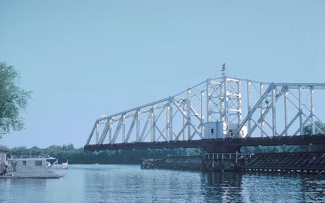
Carolyn Susor commented on Bridge Hunter: "I call this the "Mickey Mouse" bridge because the tower sheaves look like Mickey Mouse's ears."
2 of 9 photos posted by Marty Bernard.
 |
| Ted Gregory updated Ted GregoryTed and 1 other manage the membership, moderators, settings, and posts for Fascinating Railroad Structures. The BNSF (CB&Q) drawbridge across the St Croix is actually on the MN/WI state line. In this view, I am standing on the Prescott, WI side. This bridge can be a serious bottleneck as its double track on both ends. This is BNSF's Twin Cities to Galesburg, IL mainline. At Galesburg, IL, BNSF comes in from 6 different directions in to a massive hump yard (most traffic continues to Chicago). Marty Bernard The BNSF does have a line from Savanna to Galesburg. Don;t know what shape it is in. Ted GregoryTed and 1 other manage the membership, moderators, settings, and posts for Fascinating Railroad Structures. Jeff Marty I believe traffic splits near Savannah at Plum River. Priority traffic heads east to Rochelle and Aurora. Freights drop south thru Denrock, Barstow, Colona, Orion, Rio, Galesburg. South from Plum River is also old Q. I havent beeb south of Savannah to Galesburg yet. Track looks really good on Google maps. I saw an auto rack train at Gburg, a rail train near Rio, on Google satellite. All I could tell you is the amount of traffic that runs through Rochelle on BNSF is nowhere near what runs out of the Twin Cities. |
2 of 9 photos posted by Marty Bernard.
.jpg) |
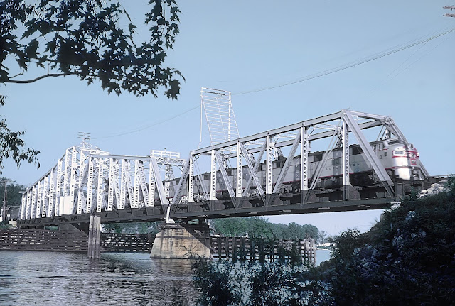
| a 7 and 8. Burlington Northern EMD SD40-2 7913 built June 1979 as CS 7913, became BNSF 7913, and seen in Prescott, WI April 23, 1994. That's the St. Croix River Bridge. The St. Croix meets the Mississippi just to the left (west) of the photo. Bill Kuba photo, Iowa Chapter NRHS Collection Paul Schmidt: At one time the house in the foreground was owned by the Burlington and into the BN years for the bridge tender. The bridge was never terribly busy with boat traffic so he could handle the job even at night on call. Come over and open and close and go back to bed. |
 |
| b 7 and 8. Burlington Northern EMD SD40-2 7913 built June 1979 as CS 7913, became BNSF 7913, and seen in Prescott, WI April 23, 1994. That's the St. Croix River Bridge. The St. Croix meets the Mississippi just to the left (west) of the photo. Bill Kuba photo, Iowa Chapter NRHS Collection |
 |
| Zach Stagman posted Prescott WI lift bridge |
 |
| 1 |
 |
| 2 |
 |
| 3 |
 |
| Robert Heathorn posted BN crossing the Mississippi river to Prescott WI. No date. Richard Fiedler shared |
Marty caught the predecessor bridge.
 |
| Marty Bernard shared 5. The CB&Q's St. Croix River Bridge, Prescott, WI 1964. Marty Bernard updated CB&Q Bridge over the Croix River, Prescott, WI This is the Q's crossing from Minnesota to Wisconsin as this train was doing on June 25, 1964. Marty Bernard posted, same comment |
 |
| Marty Bernard shared 6. The CB&Q's St. Croix River Bridge, Prwescott, WI, 1964 |
 |
| Marty Bernard posted This CB&Q Switch Tenders Shack is in Burns, MN at the bridge over the St. Croix River. At the other end of the bridge you can see a little of the town of Prescott, WI. To the right a few hundred feet is where the St. Croix River joins the Mississippi. |


