Showing posts with label canalCaO. Show all posts

Thursday, July 3, 2025

1965+2021 I-81 Bridges over Potomac River and C&O Canal near Williamsport, MD

(no Bridge Hunter; Satellite)

Metrotrails posted
The underside of the Interstate 81 bridge over the Potomac River seen from the Chesapeake and Ohio Canal towpath east of Williamsport Maryland. 
The new bridges were completed in 2021 to replace the original I-81 bridges that had been in place since 1965.
Metrotrails shared

This explains why there is no Bridge Hunter post for the 1965 bridge, it was also a UCEB (Ugly Concrete Eyesore Bridge.) According to Google Earth, construction started on the new bridge later in 2016.
Trail View, Apr 2016

"Snapshots" of the construction activity.
 Street View, Nov 2015

Street View, Nov 2017

Street View, Aug 2018

Street View, Oct 2019

Street View, Aug 2021


Tuesday, June 24, 2025

Salisbury Street Bollman Bridge over C&O Canal in Williamsport, MD

(Satellite)


I added the label "bridgeRare" because it is a Bollman bridge.

The Western Maryland Lift Bridge is in the left background.
Street View, Apr 2016

Metrotrails posted, doubled the size
Historic NPS image of Chesapeake and Ohio Canal in Williamsport Maryland approaching the pony-Pratt iron truss bridge carrying Salisbury Street to River Bottom Park. The bridge was built in 1879 by Baltimore engineer Wendell Bollman's Patapsco Bridge and Ironworks. 
There are very few remaining Bollman bridges today. Another is in Savage, Maryland, and another is on Great Allegheny Passage near Meyersdale Pennsylvania.

The Western Maryland Lift Bridge is across the top of this photo. The truss is obstructed by a pedestrian bridge on this side.
Seimen Burum, Sep 2024

Metrotrails posted
Approaching the pony-Pratt iron truss bridge carrying Salisbury Street to River Bottom Park across the Chesapeake and Ohio Canal. The bridge was built in 1879 by Baltimore engineer Wendell Bollman's Patapsco Bridge and Ironworks. 
There are very few remaining Bollman bridges today. Another is in Savage, Maryland, and another is on Great Allegheny Passage near Meyersdale Pennsylvania.
Metrotrails shared


1909,1980 US-11 Bridge over Potomac River and C&O Canal at Williamsport, MD

(Archived Bridge Hunter; Bridge Hunter; no Historic Bridges; Satellite)

The C&O Canal  and the Western Maryland Lift Bridge are in the right foreground.
Street View, Apr 2016

I was going to pass on this post until I saw the date of 1906. A steel stringer bridge back then must have been a bleeding edge design. Also, that is an impressive flood plain.
Metrotrails posted
Rt 11 Potomac River Bridge in Williamsport Maryland, seen from the C&O Canal. The nearly 1,600 ft [488m] bridge opened in 1909.
Metrotrails shared

Monday, June 23, 2025

C&O Canal Lock #44 and Lockhouse in Williamsport, MD

Lock: (Satellite)
Lockhouse: (Satellite)


Looking downstream (towards Washington DC).
Trail View, Apr 2016
Dennis DeBruler commented on the post below
This is one of the few lockhouses that have been preserved, https://maps.app.goo.gl/Q8dk3s2YCdvoP53e8.

Metrotrails posted
Historic 1919 view of Chesapeake and Ohio Canal Lock 44 in Williamsport Maryland, with lock tender and family, identified as Harvey Brant.
Codie Volkert: How long did the C&O canal run for?
Metrotrails: Codie Volkert till 1924. This section opened 1833.

Judging by the scale on this map, it looks like the lock could handle a 14' x 80' canal boat.
Satellite

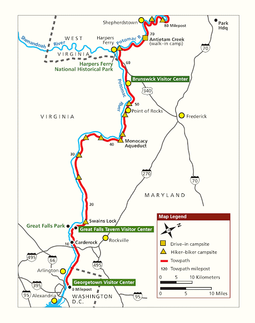
1850-1924 C&O Canal Overview

I've come across enough C&O Canal artifacts that it is time for an overview.

CanalTrust

The significance of this connection ["between the coalfields of the Allegheny Mountains and the urban markets at the upper reaches of the Chesapeake Bay"] was first appreciated by George Washington, who spent much of his private life surveying and speculating on land in the Potomac headwaters. He knew that linking the Potomac to the Forks of the Ohio (present-day Pittsburgh) would connect the young, coastal nation to the vast resources of the continental interior.

Though construction began in 1828, the canal wasn’t completed until 1850, several years after the B&O Railroad had already reached Cumberland. The canal couldn’t compete with rail in terms of speed or capacity, and so it was nearly obsolete from the time of its opening. Only bulk commodities, like lumber, wheat and especially coal, ever depended to any large extent on the canal for access to markets. Nevertheless, the canal operated (with only occasional interruptions in the wake of especially devastating floods) until 1924 when a damaging flood destroyed it beyond repair. People continued to live in cabins and shanties along the canal for another 45 years, until the national park was established in 1971. The canal’s transportation history is particularly evident along the stretch from Seneca to Georgetown where the National Park Service (NPS) has made an effort to keep it watered.


nps

npmaps_upper_detail

npmaps_lower_detail

npmaps_upper_simple

npmaps_lower_simple

nps_components
1: aqueducts
2: canal prism (This page has some details about the construction of the canal including the legal battle with the B&O Railroad concerning "the right-of-way from Point of Rocks to Harpers Ferry.")
3: lockhouse
4: lift lock - boat elevator
"There are 74 locks in total! You may say, "But there is a lock named Lock 75!" And that is because Lock 65 doesn't exist. When the canal was constructed they realized that they didn't need to build a Lock 65. The builders found it was too much work to change the name of every lock after 65 in the paperwork."
The average lift was 8' (2.4m) and the max lift was 10' (3m).

GeorgetownHeritage
Congress wanted to fill in the canal and create a parkway for automobiles. But preservationists objected and The Canal was designated a National Historical Park in 1971.

Judging by the scale on this map, it looks like the locks could handle a 14' x 80' canal boat.
Satellite via Lock #44

Canal artifacts that I have noted:


Saturday, March 22, 2025

1833,1972,2005 C&O Canal Aqueduct over Monocacy River near Potomac River

(Satellite)

C&O Canal Overview

Ian G, Nov 2016

Jim Fredlund posted
Monocacy Aqueduct
The eleven aqueducts along the C&O Canal are made from different stone - red sandstone, gray limestone, white granite, white and pink quartzite - each reflecting light differently.
The Monocacy Aqueduct, with its seven arches spanning 516 feet, is the largest aqueduct in the C&O Canal National Historical Park. The white stones, cut with large saws, were brought from a nearby quarry. They were painstakingly hand-shaped by masons, then carefully placed together to build this impressive structure. The engineers who designed them chose to make the aqueducts decorative, as opposed to leaving them with a more utilitarian look.
Standing on top of the Monocacy Aqueduct, looking at early morning fog rolling off the Potomac, you imagine a canal boat coming upon this aqueduct in the 'middle of nowhere'. How magnificent to look upon this 'Work of Art'. Morning brings a quiet grayish white, turning to a harsh white by mid-afternoon, and changing to a soft gold with hints of magenta at sunset. Each time of day sets a different mood.
The next time you visit the Monocacy Aqueduct take the time to observe this work of art, take in its beauty and grandeur, and study the changing colors of light reflecting off its stones. ~ canaltrust.org

nps, NPS photo
"The Monocacy Aqueduct (mile 42.2) is the longest aqueduct on the Chesapeake and Ohio Canal"
The aqueduct is 516' (157m) in length.
After the 1972 Hurricane Agnes flood, steel was added to stabilize the aqueduct. During 2094-05, the steel was removed and the aqueduct was restored to its original state.

Trail View, Apr 2016

Friday, September 27, 2024

US-522 over C&O Canal & Potomac River and over Main Street in Hancock, MD

River & Canal: (Archived Bridge Hunter is broke, no Historic Bridges; Satellite)
Main Street: (no Bridge Hunter; Historic Bridges; Satellite)

C&O Canal Overview

I labeled these notes as both "bridgeTruss" and "bridgeGirderSteel" because it is a hybrid of both.

Street View, Apr 2016

I include the Main Street Bridge because that is the one that Historic Bridges choose to document.
Street View, Sep 2023

Since the BridgeHunter link is broke, I can only access the index entry. Since this bridge was built in 1937, I don't know why I can't find it in HistoricBridges. It is old and it has plenty of character.
BridgeHunter_index

Metrotrails added
Chesapeake and Ohio Canal passing beneath the Rt 522 Bridge in Hancock Maryland looking east.
This bridge is an uncommon example of a combination Wichert Deck Truss and deck girder span built about 1937. It crosses the Potomac River between Maryland and West Virginia at the point where Maryland is under 2 miles wide from north to south.
Denny Baughman: Nice photo of a very unique bridge…Although I worked in the bridge industry nationwide for 50 years (including the inspection of the former wichert deck truss over the Potomac and C&O Canal downstream at Shepherdstown WV), this is a bridge type that I’ve never seen before.
M'ke Helbing shared

MDOT, SHA photo

Tuesday, January 30, 2024

1843 Aqueduct +1923 Francis Scott Key Memorial Bridges over Potomac River at Washington, DC

(Bridge Hunter broke Mar 22, 2023; Historic Bridges; HAERSatellite, 930 photos)

The Francis Scott Key Memorial Bridge replaced the Aqueduct Bridge. The Aqueduct Bridge was built to connected the Alexandria Canal to the C&O Canal in Georgetown.

Street View, Sep 2014

Image via ddotlibrary via ddot
"The Francis Scott Key Bridge was built in 1923 and is the oldest continuously used bridge in Washington, D.C....The Aquaduct Bridge was previously at this location, a structure that originally transported canal boats over the river to connect with the Alexandria Canal in Virginia. Later in the 19th century, the Aquaduct Bridge was converted to carry wagons, streetcars, and eventually automobiles across before closing in 1923 upon the opening of the Key Bridge."

The Aquaduct Bridge:
ddot
 
The canal carried by the aqueduct was an 7-mile long canal to connect Alexandria to the C&O Canal so that Alexandria could compete with Georgetown as a port. [HistoricSites]

LOT 4336, no. 13 [P&P], cropped
Aqueduct Bridge, Georgetown, D.C., looking toward Washington
 
https://industrialscenery.blogspot.com/2025/03/1845-1886-7-mile-alexandria-canal.htmlz, p5

AlexandriaVA, p6

arlingtonva
"In 1868, a second level was added to the bridge to serve as a road between Rosslyn and Georgetown for people and carts. In 1886, the bridge was closed to canal boats, but the Aqueduct Bridge continued to be used as a bridge for traffic between Georgetown and Rosslyn until 1923, when the Key Bridge opened."
 
StreetsOfWashington, c. 1865. Source: Library of Congress 
"Building the bridge's piers was the biggest challenge. The plan was to construct cofferdams at appropriate spots in the river, pump the water out and then build the piers inside them. However, they had to be built at an incredible depth—through 18 feet of water and 17 feet of silt—to reach a solid bedrock foundation. River cofferdams had never been built so deep before. The first ones erected leaked mercilessly and had to be completely replaced. The second set were little better, filling with water after an hour or so and with mud oozing in from below."
 
DCPL Commons Flickr via StreetsOfWashington, Public Domain
Aqueduct Bridge
View of Aqueduct Bridge, Georgetown University is in the background (ca 1900)
After it was used as a wagon bridge for the Civil War, a second aqueduct was built with a toll road across the top. In 1888, the aqueduct and toll road were replaced by an iron-truss road bridge.
 
CanalTrust
"By 1859, the port of Alexandria received nearly three-fifths of the coal carried on the C&O Canal."


ddot

Arlington Historical Society posted
On this day in Arlington history: January 17, 1923: the new $2.35 million Key Bridge opens. 
The Francis Scott Key Bridge, more commonly known as the Key Bridge, is a six-lane reinforced concrete arch bridge conveying U.S. Route 29 traffic across the Potomac River. Completed in 1923, it is Washington's oldest surviving bridge across the Potomac River. The Classical Revival bridge was designed by Nathan C. Wyeth and engineer Max C. Tyler and was built by the US Army Corps of Engineers between 1917 and 1923, and was named after Francis Scott Key, author of The Star Spangled Banner. 
The Key Bridge replaced the Aqueduct Bridge which was originally built to carry the Chesapeake and Ohio Canal across the Potomac to connect with the Alexandria Canal. After the Alexandria Canal was abandoned, the bridge was converted into a roadway. The Washington abutment still survives and is located west of the Key Bridge. One pier remains and is located in the river near the Virginia shore. 
The original 1923 road deck was 70' wide. It included two traffic lanes, a center lane for trolley tracks, and two sidewalks. In 1955, the trolley tracks were eliminated. The Key Bridge spans between the old Capital Transit Co. Streetcar Barn in Georgetown to its southern terminus in Virginia at North Lynn Street. The bridge rises just under 100 feet above the Potomac river below.

HAER DC,WASH,583-
4. AERIAL VIEW LOOKING NORTH TOWARDS D. C. - Francis Scott Key Bridge, Spanning Potomac River near Georgetown, Washington, District of Columbia, DC Photos from Survey HAER DC-51

Peter Moreno posted
Francis Scott Key Memorial Bridge crossing the Potomac River from Georgetown, Washington DC and Rosslyn, Virginia. It has pedestrian access for some good views of DC.

The bridge also goes over the C&O Canal.
LivingCityDC, 1 of many photos of the bridge and neighborhood
"The bridge was built between 1917 and 1923 by the U.S. Army Corps of Engineers led by Colonel W. L. Fiske....The Francis Scott Key Bridge is held aloft by five arches of varying widths: the central arch is 208' [63.4m] wide, two adjacent arches are 204' [62.2], and the last two are 187' [60m] long." For a total length of 1,701 feet long (518.5 meters). Francis Scott Key, the author of the Star Spangled Banner, lived in Washington DC.

HistoricBridges
"This attractive arch bridge is also noted as a rare example of a Melan type arch bridge with solid steel reinforcing."
 
Bridges Now and Then posted
"Potomac Boat Club with the Key Bridge under construction in the background, District of Columbia, 1921". (National Photo Company Collection)