Main Spillway: (Satellite)
East Spillway: (Satellite)
Sure enough, at 7:00am, 9,150 cfs was flowing through the turbines. An hour later the influx was down to 4,320 cfs but the turbines were passing 11,300 cfs.
It filled up in less than a year even though some people were predicting eight years. [AnotherVideo]
Massman Construction Co. posted two photos with the comment:
The Pensacola Dam impounds the Grand River to form Grand Lake o’ the Cherokees, providing hydroelectric power, flood control, and recreational benefits to the state of Oklahoma. We served as the contractor for the main superstructures, including the powerhouse and dam.The project illustrates the powerful role infrastructure investment can play in times of economic distress – we employed approx. 3,000 workers at the height of the Great Depression.A record setting structure, it is the longest multiple-arch dam in the United States and the second longest in the world and included a continuous 510,000 CY concrete placement that lasted 20 months. Our contract required the largest construction surety bond ever written up to that time.
 |
| 1 |
 |
| 2 |
 |
| 405magazine, photo and article by M.J. Alexander "The 51 arch barrels section traverses the Grand River for 4,284 feet; the length of the dam plus the spillways total 6,565 feet." It was built between 1938-1941, and it was the longest multiple-arch dam in the world. It is now 20' shorter than Canada's Daniel-Johnson Dam. |
 |
| Street View |
 |
| OKhistory, (State Historic Preservation Office, OHS). The dam is owned by the state of Oklahoma and is operated by the Grand River Dam Authority. |
Note, at 3:00am they have the turbines turned off because hydroelectricity is good for peak-demand supply.
 |
| USACE, 0300 |
Sure enough, at 7:00am, 9,150 cfs was flowing through the turbines. An hour later the influx was down to 4,320 cfs but the turbines were passing 11,300 cfs.
 |
| USACE, 0700 |
I presume the following photos were taken during the flood event of 2019.
 |
| TulsaWorld, Mike Simons State Road 28 across the top is being closed for emergency repairs. [also GrandLakeLiving, newson6] |
 |
| GrandLakeNews, Gary Crow [GRDA is applying for a 50-year license. They got a 3-year extension good to 2025. Miami, OK, thinks they mismanage floods. But they are upstream and USACE takes control of the dam during flood scenarios. More about the impact on Miami below.] |
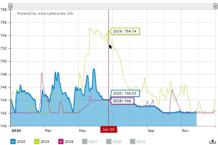
On June 24, 2019, weekend storms raised the water level two feet to 755'. Note in the above graphs that 755' is the top of the flood pool and the top of the dam is only 2' above that! The dam was releasing 145,000 cfs. [kjrh]
We can see from the year 2018 that the conservation level is raised 2' during the Summer months. Rain events have a bigger impact on the water level at the lower levels because the surface area of the lake is smaller.
 |
| GrandLake |
 |
| 360grandlake [The capacity of the six turbines should be 13,431 cfs because that is what they were running when eleven gates were opened to pass an additional 54,910 cfs.] |
"The Grand River Dam Authority began a major upgrade project in the fall 1997. [OKhistory] The current generating capacity of Pensacola is 126MW and of Kerr is 128 MW. [grda-generation]
The maximum discharge of the dam is 525,000 cfs. [Wikipedia-dam] But the kjrh article implies releases over 100,000 cfs can cause issues downstream.
The Kerr Dam on the same river is also controlled by the GRDA. Since its capacity is comparable to this dam and the dams essentially handle the same river flow, I would assume the 211 GWH per average year figure for Kerr applies to this dam as well. [Wikipedia-GRDA]
Under what authority and when was the name of the river changed from Grand to Neosho?
Is this area flat enough that the flood pool would backup all the way through Miami, OK? I checked with this topo map to learn that the flood pool does indeed come past the town.
 |
| 1973 Tulsa Quadrangle @ 1:250,000 |
So I drilled down to the 1:24,000 scale. The town is at the intersection of four quadrangles so I pulled up the three that cover the river's impact. It shows that the town itself is up on a "ledge."
 |
| 1982 Miami (NW+SW+SE) Quadrangles @ 1:24,000 |
A Street View that happened to be taken during June of 2019 shows that the water will go over the top of the dam before it inundates the town. But they have to be careful not to allow development on the other side of the river.
 |
| Street View, June 2019 |
It filled up in less than a year even though some people were predicting eight years. [AnotherVideo]
%20Facebook.png)
No comments:
Post a Comment