Tuesday, December 31, 2024

1827-1885 Union Canal Tunnel near Lebanon, PA; the Oldest Extant Transportation Tunnel in USA


Uncovering PA posted four photos with the comment: "Did you know that the oldest existing transportation tunnel in the US can be found in Lebanon, PA? https://uncoveringpa.com/union-canal-tunnel"
Ryan Alexander: They have canal rides.
Wyatt Smolick: The first existing transportation tunnel in the US actually wasn't too far away on the Schuylkill Canal near Auburn, PA, but unfortunately was reduced to an open cut over the years of its operation.
1

2

3

4

I fired up Google Earth to find a satellite image that didn't have leaves so that I could find the north portal.
Google Earth, Feb 2018

Work began in 1792, but that attempt failed financially after five locks were built. Work began again in 1821 and completed in 1828. And a branch canal was finished in 1830 to tap some coal fields and to feed some more water to the Summit Level. "The 107 locks of the Canal were built too small (8½’ x 75′) and could not accommodate the larger boats from the Pennsylvania Canal and the Schuylkill Canal. Enlargement took place in the 1850s, increasing lock size to 17′ x 90′." [LebanonCountyHistory]

"From 1827 to 1885 the Union Canal linked the commercial centers of Harrisburg, Reading, and by extension, the port of Philadelphia....Dug through the ridge dividing the waters of the Quittapahilla Creek [Susquehanna River watershed] and Clark’s Run [Schuylkill River watershed], the tunnel was originally 729 feet long. Drilling was done by hand and blasting with gunpowder through argillaceous slate rock with veins of hard flinty limestone 80 feet below the summit of the ridge....Boats were poled through the tunnel against the ceiling, while the mules were led over the top of the ridge." [LebanonCountyHistory_tunnel]

This 5:05 video talked about the geology instead of the history, so I didn't finish it.

lebtown, Credit Bob Frye
Aquisition of the right-of-way was the first use of eminent domain in the country's history. The canal reduced the travel time from Philadelphia to Harrisburg from three weeks to five days. That is a trip that is now less than 2.5 hours. Back then, Philadelphia was still the biggest market in the USA, and the canal helped move anthracite coal to that market. A Conestoga wagon pulled by six horses or mules could pull 5 to 10 tons. A canal boat pulled by just one mule could haul 50 tons. The 81-mile (130km) canal has 93 locks. (107 locks may have been the original canal, whereas 93 locks may be after it was enlarged.) The summit, Lebanon, was 311' (95m) higher than Reading and 192' (59m) higher than Middletown. For comparison the 68 miles of the Delaware Division Canal from Easton to Bristol has just 24 locks.

UncoveringPA, Public Domain
This webpage is a person visiting the canal and park rather than a history.

Monday, December 30, 2024

1989 Yokohama Bay and 1994 Tsurumi Tsubasa Bridges near Tokyo, Japan

Yokohama Bay: (Satellite, 840 photos)
Tsurumi Tsubasa: (Satellite, 289 photos)

Highway Engineering Discoveries posted
Yokohama Bay Bridge
Cable-stayed bridge in Japan ‧

hutoko_Yokohamma_overview
"The Yokohama Bay Bridge is a two-layered cable-stayed bridge that crosses the Yokohama international shipping route and is a part of the Bay Shore Route connecting Honmoku futo and Daikoku futo. The upper level is the Metropolitan Expressway and the lower level is National Route 357, and the bridge also functions as an important transportation road supporting port logistics."
Length: 860m (1/2 mile)
Center Span: 460m (0.26 mile)
Main Tower Height: 175m (475')
Inauguration: Sep 27, 1989

shutoko_Yokohama_gallery, this web page has a lot of photos

I noticed two crossings on the satellite map and the cable-stayed bridge peaking through the approach piers in the above photo, so I checked it out as well. It is the Tsurumi Tsubasa Bridge.

shutoko_Tsurumi_overview
"Tsurumi Tsubasa Bridge, which is a part of the Bay Shore Route, connects the Tsurumi channel between Daikoku Futo and Ogishima. The form of the inverted Y-shaped main tower and the central part of the road connected by cable is reminiscent of a huge bird, and as the largest cable-stayed bridge with single plane cable stays in the world, it even surpasses the Yokohama Bay Bridge in both main tower height and total length."
Length: 1020m (0.63 mile)
Center Span: 510m (0.32 mile)
Main Tower Height: 183m (600')
Inauguration: Dec 1, 1994

The intersection between the two bridges and the local roads on the port island is noteworth.
Satellite


If the sidebar content is interfering with the following construction photos, then collapse the Blog Archive in the sidebar.

Yokohama:

shutoko_Yokohama_construction

Tsurumi:

shutoko_Tsurumi_construction

Sunday, December 29, 2024

1950s 11th Street Bridge over Cedar River in Waterloo, IA

(Satellite)

Judging by the flood wall on the far right, this river has some significant floods.
Trail View, Feb 2021

I normally don't note UCEB (Ugly Concrete Eyesore Bridges), but I normally don't come across a construction photo. At least these steel girders have some character with the bottom chord curve.
Bridges Now and Then posted
Photograph of the 11th Street Bridge under construction, Waterloo, Iowa, 1953. (Waterloo Bridges Project)


Saturday, December 28, 2024

1923 Lake Decatur Dam on Sangamon River in Decatur, IL

(Satellite)

Staley had already built a pump house in 1919.

Street View, Oct 2022

Decatur Illinois - City Government posted four photos with the comment:
100 Years of Lake Decatur History: Equipment
The Lake Decatur dam has an earthen and clay core encased in concrete. In order to more efficiently move the enormous amount of dirt, clay, gravel, concrete, and other construction materials, the dam's contractor, L. M. Cope & Son, had a railroad spur built.
Fascinating to see the equipment used in the 1920s!
Each week leading up to the Centennial Lake Fest, you'll see another post about the awesome history of our lake. These weekly posts certainly won't cover ALL the history, so check out the "100 Years of Lake Decatur History" group to see more posts and share your own experiences/history - https://www.facebook.com/groups/899265747792819
Kristopher Isaac Barrington shared
1

2

3

4

DecaturIL
It was constructed during 1920-23 and the Lake Decatur filled up during the Summer of 1923.

DecaturIL
This view is from what is now 20' under water. It shows the original sluice gates. The round intake covers on the right were inlets to the original water treatment plant on Lincoln Park Drive.

DecaturIL
The Lake Decatur dam has an earthen and clay core encased in concrete.

Originally, the rim of the dam was lined with sluice gates.
presentation

In 2010, "bascule gates" were installed. I would call them wicket gates.
presentation

Here the south half is open, but the north half is still closed.
presentation

They definitely favor using the south side of the dam for spilling water. According to street views, they added that "railing" across the top between Mar 2012 and Nov 2015. I don't know why.
wandtv, Jul 25, 2022

wandtv_action
In 2016, the city approved $102k for an emergency action plan.

0:54 video @ 0:09


May 1977: an Oakley Dam was proposed upstream on the Sangamon River to offset the water supply capacity lost to silt in Lake Decatur. But some professors at the University of Illinois fought the dam for 30 years and that was enough for inflation to decrease the cost-benefit ratio of the dam below 1. That ratio killed planning for the dam.

Friday, December 27, 2024

1916 CSX/Pere Marquette Trestle over Rabbit River in Hamilton, MI

(Archived Bridge HunterHistoric BridgesSatellite)

I'm always a little surprised when I see a Class I railroad still using a wood trestle.

Street View, Oct 2012

Andy Gras posted
Chessie on the trestle at Hamilton Michigan in 1980.  Now this trestle is always a favorite spot for fishermen to fish when spawning season comes.  Fish leap the falls.  Its on the Rabbit River and Hamilton has a restaurant named after it, called The Trestle Stop.  Anyway, lots of pics are taken of this trestle, but the problem with me was, that it never had Chessie on it.  So that day I needed to fix the problem.
[According to some comments, CSX still operates the route, but at 10mph.]
Dennis DeBruler shared
Fortunately, the leaves were off the trees so that we can see the caboose.

HistoricBridges

Thursday, December 26, 2024

Slator/Austeel/Thomas Steel in Lemont, IL

(Satellite, "The building still stands,but is no longer a steel plant.It is just across the BNSF tracks.It is now used a warehouse for road salt storage." [ItsFilmedThere, an anonymous comment on "May 6, 2012 at 1:54 PM"])

As recently as 1988, Thomas Steel must have been prosperous because they doubled the capacity from 200k to 400k tons per year. [apttech]

In 2000, some of their rebar got rejected by the NY DOT. [dot_ny]

Slater bought Austeel in 2002. [stainless-steel-world] I recognize the name Slater Steel because they bought Joslyn Stainless Steel in Fort Wayne, IN.

Ray Proskey posted
1996. Austeel-Lemont in Lemont, IL. Me standing next to the 2500HP synchronous motor for #1 Rolling Stand.
Bob Adams: Ormet in Hannible Ohio had 2500 hp compressors just like that

Art Wright commented on Ray's post
Try these 2000 HP synchronous motors in north motor room old Gary Rail Mill 1907 manufacture.

Dan Plute commented on Ray's post
12 10 bar mill Bethlehem Seattle.

Ray Proskey posted
The current state of Austeel-Lemont. Before I started working there, it was known as Thomas Steel. A scene from the movie Rudy was shot there, which shows the Main Pulpit and some rebar going through the repeaters. 
Right half of building is the melt shop. The left half is the rolling mill.

Ray commented on his post
Andy Horath: Ray Proskey pic is of the original cross-country mill. It was scrapped and a new continuous built. That xc mill was wild.

Ray commented on his post
From Rudy.

Comments on Ray's post

Wednesday, December 25, 2024

1956 Baitings Dam near Littleborough, UK

(Satellite)

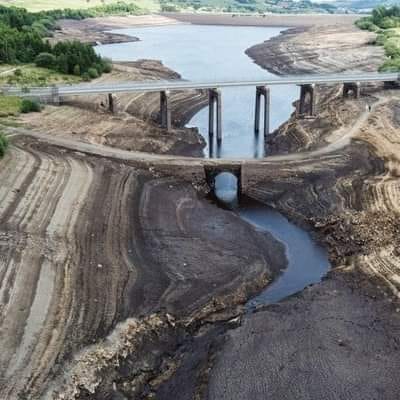
The purpose of this dam is water supply, not flood control; so a very low reservoir would be a serious issue.
The reservoir is owned by Yorkshire Water.

Bewildering Nature posted
Low water levels at Baitings Dam in Yorkshire reservoir exposed a Viking era packhorse bridge submerged since the 1950s
[Evidently this photo is old, the following source indicates the drought happened in 2022.
Also, all other sources call it a Middle Age bridge. I think the Viking era is too old.]

exploringgb
"2022 was one of the driest in 500 years."

Szymon, Jan 2021

Michael Bailey, May 2023

1875-1972,2011 Medora Covered Bridge over East Fork of White River near Medora, IN

(Satellite)

Satolli Glassmeyer posted
*New  Documentary*
Medora!  Longest  Covered  Bridge  in  the  United  States!
Two  important  aspects  about  this  documentary.  First,  for  over  10  years  I  have  been  trying  to  find  someone  to  fund  a  video  project  about  this  very  historic  bridge.  That  finally  happened  two  weeks  ago  and  without  their  help,  this  video  would  never  exist.  Thank  you!  Secondly,  I  was  told  about  where  I  could  find  the  initials  of  the  stone  masons  who  built  the  abutments  and  piers  in  1875  and  I  found  them!!!!  The  story  is  in  the  comments  below.
Tim Berry: The Cornish-Windsor Covered Bridge between Cornish, NH and Windsor Vermont is 449' 5" and still carries traffic, two spans.
[Why don't people just include the link in the description?]

431' long (131m)
The state spent over a million dollars in 2011 to restore the bridge.
I watched this video when it showed up in my YouTube feed. I don't like "come explore with me (i.e. watch me walk)" videos so I stopped watching at 12:00 when I got another ad.


Tuesday, December 24, 2024

1966 Lincoln Trail Bridge over Ohio River between Cannelton, IN, and Hawesville, KY

(Archived Bridge Hunter; no Historic Bridges; Satellite)

The official name is Bob Cummings Lincoln Trail Bridge.

Street View, Sep 2024

Bryan Burton Photography posted
The Excell Marine Winchester heading towards the Lincoln Trail Bridge that crosses the Ohio River between Cannelton, IN and Hawesville, KY. 12/2024

BridgeHunter
This 2,708' (825m, half mile) long bridge has a main span of 825' (251m).
The average daily traffic in 2004 was 8,338.

Both sides of the river have high levees so I could not get non-profile street views. Fortunately, Valerie took some photos of the bridge.

Valerie Kastler, Jun 2018

Valerie Kastler, Jun 2018