Bridge: (Archived Bridge Hunter; Bridge Hunter; no Historic Bridges; Satellite)
This is one of the lower river levels that I found.
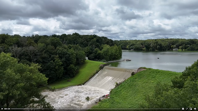
The dam is 1600' (488m) long and 50' (15m) high. Its maximum storage is 13,460 acre-feet. The spillway has a width of 112' (34m). Even though it provides a water source for the region, recreation is considered its primary purpose. [snoflo]
 |
| Tyler Schmitt, Realtor, RE/MAX Alliance posted 3:00 video Here is some footage of Vandalia Lake and the Kaskaskia River after all this rain we had last night (7-20/21-2025). Not something you see every year! Bryan Grubaugh: We used to take inner tubes over that damn. Ronda-Ian Brown: Did that flood the road by the spillway.... Bj Tedrick: Ronda-Ian Brown definitely David Cantrell shared with the comment: "Flooding video around Vandalia from Tyler Schmitt. It has a railroad bridge and tracks visible in part of the footage (around 1:40). I'm unsure of which railroad is shown." Paul Brewer: Bridge is CSX - St. Louis Line. Nice video! |
Bear Creek empties into the Kaskaskia River northeast of Vandalia so that river is also running high.
The road bridge in the foreground is US-51.
%20Video%20_%20Facebook.png) |
| Same video |
This is one of the lower river levels that I found.
 |
| Street View, Dec 2022 |
CSX has done some work over the last decade to improve the piers.
 |
| Street View, Oct 2013 |
 |
| Uploaded by Melissa Brand-Welch via BridgeHunter |
%20Video%20_%20Facebook.png) |
| Precision fishing guide services posted 0:30 video The dam at vandalia lake |
I presume this is the road by the spillway. Google Maps does not have a street view of that road. This video was posted Jan 11, 2020. Five years ago.
%20Video%20_%20Facebook.png) |
| Same video |
No comments:
Post a Comment