Normally, a lock is associated with a dam to allow boats to go around the dam. In this case, they dammed the DuPage River near its mouth to save the cost of an aqueduct to take the I&M Canal across the river. The bridge across the dam was the canal's tow path, and it is now the Illinois and Michigan Canal Trail.
 |
| 20140627 0189 |
Lock #6 on the north side of the canal lowered the canal down to the dam's reservoir and...
 |
| 20140710 0005 |
...Lock #7 at the south end of the dam lowered the canal some more.

This view is from the east side of Lock #7 looking up the dammed waters of the DuPage River. The tow path bridge is on the right and the bridge for US-6 is in the middle background.

This view is from a bridge over Lock #7 looking North. The dam is along the right side. In the middle background we are looking into Lock #6 and...

 |
| Digitally Zoomed |
After a couple of sign images, I display details of the two locks, the ruins of a mill race and the dam.
You should save these signs to your hard drive and look at them with your favorite photos viewer to get better resolution. Even if I make them "extra large," they are unreadable inline.


Lock #6
This view of the downstream gate area shows the lock house that has been preserved.
 |
| 20140627, all photos are from the 20140710 trip unless labeled from the 20140627 trip |
I can't believe I didn't get closeups of the lock house since I think only other preserved lock house is at Aux Sable. This upstream view is from the little bridge across the lock that allows you to get closer to the lock house. This provides a good view of the water cascade that we saw earlier looking across the DuPage River from Lock #7.

Lock #7
This view is looking south from a bridge over the lock. We can see part of the recesses for the gates in the walls.

After I crossed the bridge, I looked back and took a photo of the sunny (east) wall. It appears they have gone to a lot of work to replace only the stones that needed replacement.

But the inside of the lock needed more extensive repairs.

On my way back, I got below the handrail of the bridge to take another view looking South. This did a better job of catching the recesses in the walls for the gates.

 |
| Illinois and Michigan Canal Photo Tour posted Locks 7 and 6 (background) at Channahon about 85-90 years apart. A small shack for the locktender once stood at the NW edge of lock 7. [Others have provided photos in the comments.] |
Mill Race Remnants
West of Lock #7 is the control structure for a millrace. The mill itself is long gone. I put a red rectangle around the sluice gates for the millrace that is barely peaking out above a tree. I can't tell where the mill itself used to be. I verified that this area was already trees instead of buildings in a 1939 aerial photo.
 |
| Satellite plus Paint |
On the right we can see the control rods that control the sluice gates. There must be three gates and the middle one is open. My wife found this mill race while she was killing time while I took photos of Lock #7. She ended up having to kill even more time as I took photos of this structure.

Here we can see the downstream stone work of the raceway and the dam with its bridge in the background.


The Dam
South of the spillway there is an earth embankment. Note how they have reinforced the embankment with interlocking steel pilings. About a fourth of the way in from the right is the inlet for the mill race.


Another attempt to catch an overview of the downstream turbulence. It is also another demonstration that I have a hard time holding the camera in a profile position when leaning over a rail.

Looking straight down over the handrail.

And my upstream shot also shows that I can't hold the camera vertically when leaning over the rail. In addition to showing some snags, it shows that there seems to be a mini-crest on the upstream side of the dam. I've never seen that before on other dams.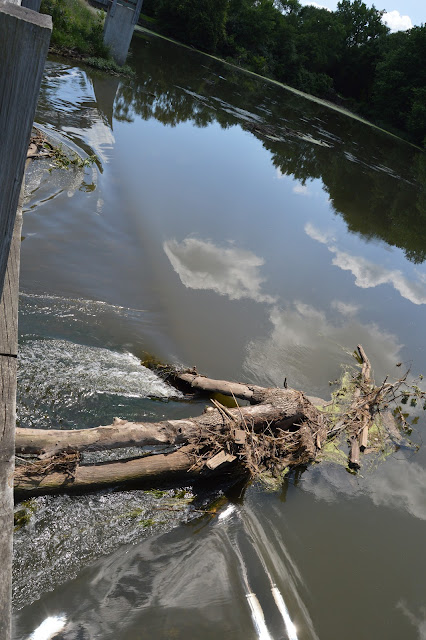

Is this the same snag a few weeks earlier? This photo also catches the "brown line" of the min-crest.
 |
| 20140627 |
There is a nice park near the downstream side of the dam. The trail head near Lock #6 has a parking lot.

No comments:
Post a Comment