Friday, June 7, 2024

1929,2003 Lewis and Clark Bridge over Columbia River at Longview, WA

(Archived Bridge Hunter; Historic BridgesSatellite, 177 photos)

HAER WASH,8-LONVI,1--1, cropped
1. LONGVIEW BRIDGE FROM UPSTREAM SIDE IN ELEVATION - Longview Bridge, Spanning Columbia River at State Route 433, Longview, Cowlitz County, WA

Michael Goff via Bridge Hunter

"Significance: The Longview Bridge, designed by engineer Joseph B. Strauss, was at time of construction the longest cantilever span in North America with its 1,200' [366m] central section. Extreme vertical and horizontal shipping channel requirements requested by Portland, Oregon, as a means to prevent the bridge's construction created the reason for such an imposing structure." [HAER_data and BridgeHunter]

HAER WASH,8-LONVI,1--13
13. OBLIQUE VIEW OF MAIN SPAN
 
Bridges Now and Then posted
"The Longview Bridge opened for public use on March 29th, 1930. The bridge crosses the Columbia River between Longview (Cowlitz County) and Rainier, Oregon. At the time of its construction it was the longest and highest cantilever bridge in the USA at 8,289 feet in length and with a roadway 210 feet above the water." (Longview Public Library)

Lewis & Clark Bridge
Posted March 18, 2013, by Nathan Holth (webmaster [at] historicbridges [dot] org)

Enjoyed looking at the article. Each historic bridge has a unique story, and I simply feel it should be told as accurately as possible which I why I felt the need to point out the length issue. The story of this bridge is certainly very unusual... the construction of a monumental sized bridge not out of need, but out of politics. It also is one of the few large-span bridges that famous engineer Joseph Strauss actually designed (given that he didn't really have as much to do with the Golden Gate as he and his statue would have you believe). Strauss proposed a design for the Blue Water Bridge in Michigan that was not accepted, but clearly was based off his design for this bridge.

The story of Pont de Quebec is also quite a story, where the effort to construct the world's longest cantilever span took two tries and took the lives of 88 people.

Lewis & Clark Bridge
Posted March 18, 2013, by K. A. Erickson

Nitpick. Nitpick.

I am sure they meant USA or perhaps if there is a Midwest span, longest in the Pacific Northwest.

Do you realize the efforts it took to even get this bridge up? Portland did not want a bridge at Longview and kept imposing new restrictions on design hoping it would not get done. They feared loss of vital shipping with a low span. However, since these types of bridges were quite common on the Missouri, Mississippi, and Ohio Rivers it was easy to do.

http://www.crreader.com/2012/02/24/Columbia-River-History-Bu...

Lewis & Clark Bridge
Posted March 18, 2013, by Nathan Holth (webmaster [at] historicbridges [dot] org)

I don't mean to diminish the extremely high level of historic significance of this magnificent, beautiful historic bridge, however the claim by HAER that its 1200 foot span was the longest in North America when completed is false. Pont de Quebec opened in 1917 has been and likely forever will be the longest cantilever truss span in North America and indeed the world with its 1800 foot span between piers. http://www.historicbridges.org/bridges/browser/?bridgebrowse...


Street View, Oct 2023

HistoricBridges

"In addition, it gave a 185' [56m] minimum vertical clearance at the channel piers and 195' [60m] at mid-span. The structure's extremely long cantilevered portion and unusually long anchor arms were required to comply with the permit's order to construct only one pier between the main channel and the Longview pier-head line." [HAER_data]

Albin Kampfer posted five photos with the comment:
Hello, first thanks for the add.  Second, I enjoyed looking at & reading about the Astoria-Meglar Bridge which is near where I live.
This is the Lewis and Clark Bridge about 50 miles up the river from the bridge in Astoria.  It’s the only crossing in the lower Columbia between Astoria and Portland.  
It was completed in 1930 got its name in 1980.  A privately owned bridge at first, the station of Washington bought it in 1947.  It was a toll bridge until 1965 when bonds were paid off just like the bridge in Astoria was a toll bridge until 1993 when its bonds were paid off.  The bridge is 2772 feet long linking Rainier, Oregon to Longview, Washington.
In the one picture you can see Mt. St Helens in the background.
1

2

3

4

5

Facebook Reel


Thursday, June 6, 2024

GM&O/Alton/C&A Orendorff Bridge over Townhall Road near Hopedale, IL

(Satellite)

Unfortunately, no street view driver has driven on this segment of Townhall Road.

John Woodrow posted
GM&0  233 (Jack line) at the Oredoff or Town Hall bridge at Hopedale Illinois  1- 27-1963  (Edward Wayne Bridges photo)
Steven Hooker shared

Larry Candilas commented on John's post
A few years later
John Woodrow: Larry Candilas that is also Edward Wayne Bridges photo

1951 Minier Quad @ 62,500

Wednesday, June 5, 2024

1923 Route 66 Rainbow Bridge over Brush Creek near Baxter Springs, KS

(Archived Bridge HunterHistoric Bridges; Satellite, 799 photos)

"Historic Route 66 only enters Kansas for a few miles, but in that short distance it is interesting to note that travelers are treated to the one historic bridge type that is so uniquely Kansas: no other state boasts as many surviving rainbow arch bridges (Marsh type or otherwise) as Kansas does. Indeed, this is the only rainbow arch bridge on the entirety of Historic Route 66." [HistoricBridges]

Street View, Apr 2023

Street View, Apr 2023

Given that the 1923 bridge is just one lane, I'm surprised they waited until 1992 to bypass it.
Street View, Apr 2014

1 of 12 photos posted by Michael Rodgers Photography
Double Rainbow over Rainbow Bridge on Kansas Route 66.
Mike Rodgers shared
John Weeks: Rainbow arch bridges are pretty rare to begin with, but seeing a rainbow at the same time seems like a one in a billion thing. Congrats on either good luck or fantastic planning!
Mike Rodgers: John Weeks thank you it wasn't planned I was going to Galena Kansas for their city wide yard sale and there it was I had to pull over

When I saw the "signature photo" for the town of Baxter Springs, I figured this town was on Route 66. This filling station is now a Route 66 Visitors Center.
Peter Cowling, Nov 2022

Tuesday, June 4, 2024

1973 Rend Lake Dam on big Muddy River near Benton, IL

(Satellite, 295 photos)

This is one of those topics for which I can't believe I don't have any notes. So it is time to get them started.

USACE, St. Louis District posted two images with the comment:
Rend Dam is owned and operated by the St. Louis District and is located in Benton, Illinois on the Big Muddy River. Rend Dam creates Rend Lake, which helps reduce flood risk, supply water to nearby communities, provides habitats for fish and wildlife, and provides recreational opportunities. To learn more about Rend Dam and plan your visit, go to https://www.mvs.usace.army.mil/Miss.../Recreation/Rend-Lake/.
1

2

The spillway in the photo is a small fraction of the length of the dam.
(Satellite)

Dale Stafford, May 2023

Like California, this dam was built for water supply. (Most big reservoir dams in the Midwest are funded for flood control.)
"For decades the land surrounding Rend Lake was plagued by lack of water - despite plentiful rainfall, and its location between two of the nation's great rivers, the Mississippi and Ohio....The land's impermeable clays were incapable of soaking in rain, making ground water scarce. By the 1950's the onset of an economically devastating three-year drought, took its toll on the region. As a result, plans to construct a large water supply lake began to take form, one that would be the solution to the area's problems, and evolve into the project that would become Rend Lake.... It supplies over 15 million gallons of water per day to 300,000 persons in over 60 communities." [USACE_history]
 
Dale Stafford, Sep 2022

I have not found a length for the spillway or dam, but judging from Google Maps, the dam is about 2 miles (3km) long, and the spillway is about 450' (140m) long. The spillway "notch" is about 30' (9m).
USACE_brochure

Given that the lake has reached a height of 413.83', I assume that 405' is the height of the bottom of the notch and 410' is the height of the top of the notch, which is the height of the main spillway. That means during the May 1995 flood, the water was almost 4' (1.2m) deep over the crest. That would have been getting kinda close to the top of the dam.
Street View, May 2018

Looking at Google Earth, only the Mar 2015 view was using the entire spillway.
Google Earth, Mar 2015

On the other hand, just a couple of Gobal Earth views had a dry spillway.
Google Earth, Oct 2017

Apr 5, 2025:
WFCN News - Swinford Media Group posted @ 0:01
Here is a look at the Rend Lake Dam as of this [Apr 5, 2025] afternoon, which is already overflowing due to excessive rainfall. The lake is expected to crest later in the week.
📸 Reporter Aaron Price
Dylan Henry: It's highest crest ever was 413.83 in 1995. It's currently just over 411. Almost 7 feet over normal pool.
[According to some more comments, it got up to 413.57' around Apr 7 at 5:28pm.]

@ 0:11


Monday, June 3, 2024

1926 NS/Pennsy New Brighton Bridge over Beaver River at Beaver Falls, PA

(Archived Bridge Hunter; Historic Bridges; HAER; Satellite)

"This railroad bridge is composed of very heavy but shallow riveted deck truss spans. The truss shape was dictated by a  need to maintain the existing railroad elevation, but also to provide clearance for a proposed canal." [HistoricBridges]

Street View, Dec 2015, Gimp brightness: +50, contrast: +35

MP Rail Photography posted
NS 66X, ethanol loads for Reybold, DE, head eastbound on the Ft. Wayne Line.  With an NS SD70ACe leader, the train is seen crossing the Beaver River at Beaver Falls, PA.
May 26, 2024
Beaver Falls, PA
Power:
NS 1038 - SD70ACe
CP 8565 - AC44CW
NS 9953 - C44-9W

And this view would be looking at the other side.
MP Rail Photography posted
NS 4425 and NS 3956 lead 23G across the Beaver River in Beaver Falls, along the Ft. Wayne Line.
May 26, 2024
Beaver Falls, PA
Power:
NS 4425 - AC44C6M
NS 3956 - C44-9W (Former KCS/BNSF Power)

The Pittsburgh & Lake Eire (P&LE) is the railroad that goes under the Pennsy on the west side of the river.
HAER PA,4-NBRIG,1--1
Left panel of panoramic overview of Beaver River Bridge and New Brighton, looking NE from Patterson Heights, abuts PA-511-2 - Pittsburgh, Fort Wayne & Chicago Railway, Beaver River Bridge, Spanning Beaver River along line of Second Avenue, New Brighton, Beaver County, PA
[Note the abandoned bridge piers and dam in the background.]

"Significance: The Pittsburgh, Fort Wayne & Chicago Railway's Beaver River Bridge includes several unusually shallow and heavy skewed Warren deck trusses. The interesting and well-documented history of this crossing includes a rare instance of highway and railroad bridges trading places." [HAER_data]

HAER PA,4-NBRIG,1--6
Interior view of fixed end of northernmost truss span, looking due south.

1953 Beaver Quad @ 24,000

This is the flyover mentioned in PRJ's comment below.
Satellite

So were were these bridges?
Jackson-Township historical preservation posted
View from the Country Club of the community of Beaver Falls, Beaver County in 1905.


Sunday, June 2, 2024

1889 South Fork Dam Flooding of Johnstown, PA

Ruins: (Satellite)
NPS Visitor Center: (Satellite, 2490 photos)

USACE, Pittsburgh District posted two images with the comment:
Today [May 31] marks a somber anniversary — the 1889 South Fork Dam disaster in Johnstown, Pennsylvania. As we observe National Dam Safety Awareness Day, let's reflect on the lessons from the past to safeguard our future.
The South Fork Dam, originally built in the 1840s for the Pennsylvania Main Line Canal, experienced a catastrophic failure on May 31, 1889, releasing approximately 3,600,000,000 gallons of water. This tragic event resulted in over 2,200 lives lost and immense property damage, highlighting the critical need for diligent maintenance and safety protocols in dam engineering.
Through the years, from its initial construction to its eventual failure, the dam's history can teach the nation about the dangers of neglect and the importance of robust infrastructure. In 1879, changes made by the South Fork Fishing and Hunting Club compromised the dam's integrity, directly contributing to the disaster. This included removing crucial discharge pipes and lowering the dam's height to accommodate carriages, while also failing to maintain essential spillways.
Today, the U.S. Army Corps of Engineers Pittsburgh District is committed to preventing such tragedies. Our dam safety program follows strict safety regulations and conduct regular inspections to ensure the structural integrity of our nation’s dams.
📽️ Explore more about the South Fork Dam and its history through photos and timelines from our friends at the HISTORY:  https://www.youtube.com/watch?v=Zj2v5Akm1Bg ["It was the biggest man-made lake in the world." This video shows a masonry dam breaking, but it was an earth dam that was overtopped.]
Let’s honor the memory of those lost in Johnstown by committing to excellence in dam safety and infrastructure management. Together, we can protect communities and lives.
U.S. Army Corps of Engineers Pittsburgh District: Photos sourced from the National Park Service
Pam Walaski: Important to remember who made the changes to the dam that led to its eventual collapse. The Club was a playground for the Pittsburgh elite - Andrew Carnegie and Henry Clay Frick to name a few. David McCullogh’s book is an excellent read in this tragedy.
1

2

nps
"The remains of the South Fork Dam from the Visitor Center area."
The dam had already failed in 1847 and 1862.

PowerLibrary via search, Educational use permitted

As the dam was built and maintained by the Pennsylvania Main Line Canal and the Pennsylvania Railroad.
1. The dam was watertight due to puddled earth or being packed down. 
2. The dam had a spillway that was unobstructed, allowing for runoff. 
3. There was a control tower in the middle of the dam. 
4. There were discharge pipes in place at the base of the dam, allowing the water level to be controlled. 

As damaged by private owners.
nps
1. The earth is not puddled and there were several leaks in the dam.
2. The spillway is obstructed with a bridge and fish screen.
3. The control tower burned down and was not replaced. 
4. The discharge pipes were removed and the lake level was filled up to 70 feet in places. 
5. To widen the road across the dam, it was lowered.
6. In 1862 the dam broke, resulting in a sag in the middle where repairs had been made.

This 13:30 video also shows a masonry dam bursting. But the narration calls it an earthwork dam. "When finished, it was the largest earth-work dam in the world." 284m (931') long and 22m (72') high. This video skipped the private ownership that removed the outlet works. It does a good job of describing the flood damage. The $17m damages is about $500m in today's money.

Facebook Reel


Saturday, June 1, 2024

Eglinton Crosstown West Extension Project in Toronto, ON

East End: (Satellite, this part of the project has yet to happen.)
East End of Phase I: (Satellite, image was too old to show construction activity.)
West End: (Satellite, image was too old to show construction activity.)

Herrenknecht Deutschland posted
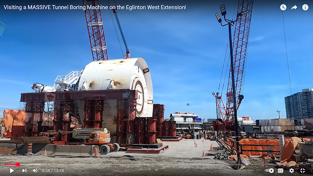
Congratulations to the WestEnd Connectors Construction on the second and final breakthrough at the Eglinton Crosstown West Extension Project. After approximately 25 month of mining, two 6.58m #Herrenknecht EPB shields completed both tunnels of the alignment for Metrolinx and Infrastructure Ontario. The extension of the Eglinton Crosstown LRT will run 9.2 kilometers from the future Mount Dennis LRT station to Renforth Drive and will operate mainly underground. Once complete, it will create a continuous rapid transit line that stretches from Scarborough, through midtown Toronto, and into Mississauga. Seven stations are being added along the route. 
This new infrastructure will reduce significantly local traffic load.

Above was the breakthrough of the Renny TBM. Below is the breakthrough of Rexy, which happened on Apr 26, 2024.
metrolinx

aecon
This first phase of the work started in 2021 and was valued at $729.2m. It goes between Renforth Drive and Scarlett Road.

These high-rise buildings and signs confirm that I found the correct east end of Phase I. Phase II will construct elevated tracks east of here to go over Humbler River. The tracks will then go back underground east of Jane Street to connect with Mount Dennis Station.
Street View, Sep 2023

A video of Rexy's breakthrough. See what these TBM's do with rebar, I find it hard to believe that a pipe is what wrecked the TBM in Seattle a while back. (The second video in Chiltern Hills Tunnel also shows a TBM chewing through rebar at its breakout.)
0:23 video

13:18 video