Saturday, November 20, 2021

CSX/C&O James River Viaduct and Tredegar Iron Works in Richmond, VA

(Bridge Hunter; Satellite, this is the western side; Satellite, on the eastern side it follows Dock Street to the Fulton Yard)

This is the west end of the C&O viaduct along the north side of the James River and I included the Tredegar Iron Works buildings which now house the American Civil War Museum. The 9th Street Bridge is in the background.
Street View
 
The same view as above, but about four decades earlier. 
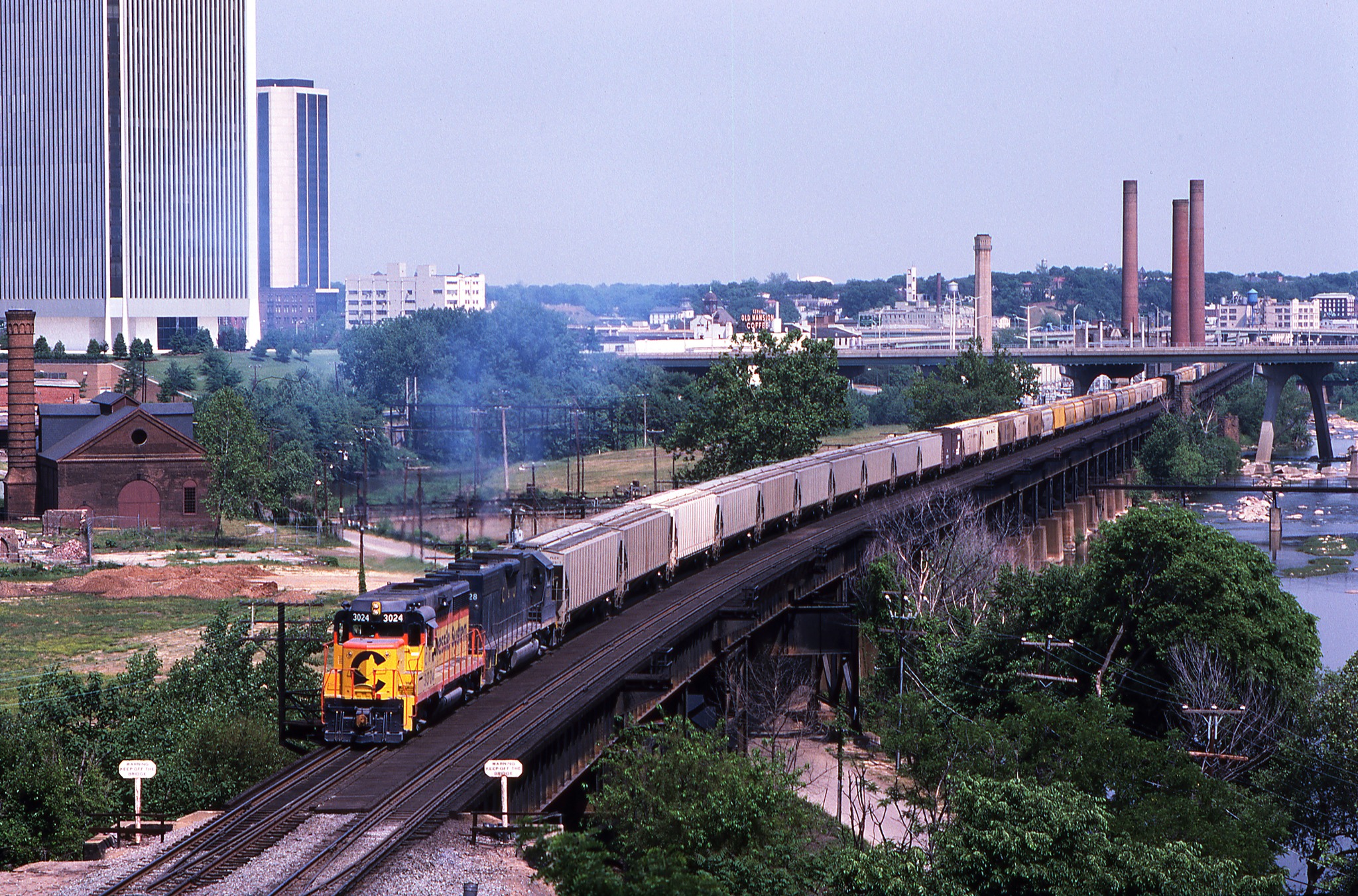
Stanley Short posted
Westbound Chesapeake & Ohio manifest No. 91 is at the west end of the James River Viaduct in Richmond, VA on May 15, 1983, led by GP30 No. 3024. It is taken from the old Lee Bridge (U.S. 1), which has since been replaced. Thankfully, it is still possible to shoot from the new bridge. That said, the scene has changed dramatically. The Federal Reserve Bank in the upper left and the James Monroe Building, to its right, remain. The brick building on the left is the old Tredegar Iron Works, which predates the Civil War. It has since been restored as a museum. [my emphasis] The area in the lower center and right of the image is now a beautiful public park, with plenty of parking. The smoke stacks are gone, and much of the center and background are occupied by high rise buildings. One added note, the small sliver in the middle extreme right was part of a dam across the James River. It remains and extends out into the river several hundred feet. It is part of the park and a viewing platform has been built at the end, providing a nice vantage point for shooting eastbounds on the viaduct.

Dennis DeBruler commented on J.B.'s share
I knew CSX/C&O was the top level of the triple crossing. Now I better understand how it got so high.
CSX/Seaboard Air Line is the middle level and NS/Southern is the ground level.

James Starkey posted
Richmond, VA
1979
My image

Looking East from the 9th Street Bridge. The I-95 Bridge is in the background.
Street View

Advanced Approach Photography posted
“Rollin’ Coal”
After waiting for a westbound empty out of Fulton yard to clear Rivanna Junction, eastbound loaded coal train CSX C123-14 eases across the C&O Viaduct along Tobacco Row in Richmond.
Worldwide Railfan Productions shared

Ted Gregory posted
One of the most famous Viaducts in US Railroading...
Christopher Love: Richmond?

Dennis DeBruler commented on Christopher's comment
That is the clue I needed. It is the James River Viaduct of the CSX/C&O, which is the top level of the Triple Crossing (https://maps.app.goo.gl/YX8UQiLfrXrxGHA5A). https://maps.app.goo.gl/oYHZnWBD9qddEux49

Looking West from a I-95 ramp.  The Triple Crossing is along the right side. I caught a MoW truck on the CSX/SAL route.
Street View

Looking East from another I-95 ramp. The tracks curving under the bridge is the James River Viaduct. The tracks continuing along the flood wall go to the Main Street Station. The canal is a topic for another day.
Street View

Once we get east of the jog in the flood wall, I can use Dock Street to get views of the viaduct, which is good because there are no more road bridges across the river. In the foreground below is the route to the Main Street Station and behind it is the route that continues along the river shore. Note the steel door that would close the hole in the flood wall that allows Dock Street to go through the wall.
Street View

But of particular interest is the spindly trestle under the current trestle. The spindly trestle is obviously now a trestle to nowhere. I wrote a couple of theories as to the purpose of that trestle. But I have deleted them because I agree with PRJ's comment: "The under-trestle looks like protection for the bike/walking trail from potential falling debris (spikes, track bolts, etc) from the trestle." If you look at the following street views, the spindly trestle exists only where the trail is below the railroad trestle.
Street View

This is the same location as above, but looking Southeast to show more of the spindly trestle under the current trestle.
Street View

Looking Northwest from where Dock Street leaves the side of the James River Viaduct. 
Street View

The spindly trestle ends as Dock Street and the trail leave the James River Viaduct.
Street View

The James River Viaduct gradually becomes lower to get back to ground level. I picked this sample of the descending viaduct to catch a movable bridge across the canal for the NS/Southern route.
Street View

The viaduct ends at Nicholson Street where the tracks use an embankment.
Satellite

Stanley Short posted
We are on CSX's former-C&O James River Viaduct at Rivanna Junction in Richmond, VA on March 6, 1994. Two SD40-2's have brought a unit coal train down the Rivanna Subdivision and is waiting for a fresh crew to take the train to Newport News. Rivanna Junction interlocking connects the Rivanna, Piedmont and Peninsula Subdivisions. Photo by Stan Short.

Randall Hampton shared

Dennis DeBruler commented on Randall's share
And the train is on the top level of the triple crossing that is on the other side of I-95..

Stanley Short posted
An eastbound CSX unit grain train rolls down the James River Viaduct in Richmond, VA on Nov. 23, 1996 with two SD40-2's bracketing an SD50. We are standing on the bridge abutment for the old Atlantic Coast Line bridge into Richmond. This area is now a city park and easily accessible. The tall building on the left houses the Richmond Federal Reserve Bank. Photo by Stan Short.

Randall Hampton shared
E.V. Welton: Did the line run through a tunnel through downtown?
Randall Hampton: No, there's been some grading work done for the highway. The only tunnel I've heard about in Richmond is on the east side of town, abandoned. The city was quite old when the railroads arrived, so there was a lot of street running in the early days, and single tracks in grassy medians. It took a lot of time and money to get everything out of the street and double track the most important lines.


That abutment is now a free climbing wall.
Andrew Blake, Sep 2020

Friday, November 19, 2021

1969 RI-138 Claiborne Pell Bridge over East Passage Narragansett Bay at Newport, RI

(Bridge HunterArchived Bridge HunterHistoric BridgesSatellite, 613 photos)

The main span of this 11,248' (3428.4m, 2.1 miles) bridge is 1,600' (488m). [HistoricBridges]
The average daily usage in 2015 was 20,010 with 2% trucks. The navigation vertical clerance is 30.4m (100.1'). [NationalBridgeInventory]

The Mount Hope Bridge is another suspension bridge that helps connect Newport with the mainland.
The suspension span is on the west side of the bridge. 

Street View, Sep 2012

C Hanchey Flickr, License: Creative Commons Attribution-NonCommercial (CC BY-NC), cropped
It "was renamed for U.S. Senator Claiborne Pell in 1992.

This bridge is like the Mackinac Bridge in that the suspended part is just a fraction of the total length. I could not find a length for the side suspended spans, but they look about half the distance of the main span. So the suspended part of the bridge is about 976m or 976/3428.4 = 0.28 of the total length.
Street View, Jul 2012

"The bridge features an extremely long approach system of deck truss spans, deck plate girder spans, and concrete beam spans." [HistoricBridges]

The above street view shows some of the concrete beam spans and this photo shows some of the deck truss spans. The photo also provides a closeup of one of the cable anchors.
C Hanchey Flickr, License: Creative Commons Attribution-NonCommercial (CC BY-NC)
 
Rhode Island Memories posted
Newport Harbor Lighthouse on the north end of Goat Island in Narragansett Bay in 2008.
Bridges Now and Then shared

This bridge replaced a ferry service. The main span of this 2.1 mile bridge is 1,601' (288m). The towers are 400' (122m) high and provide a clearance of 215' (77m). "It remains the longest suspension bridge in New England." It carries 27,000 vehicles a day. Claiborne Pell was a senator. "An image of the bridge appears on the back side of the Rhode Island version of the U.S. quarter." [ritba]

Bridges Now and Then posted
Lifting the middle piece of deck structure into place on Rhode Island's Claiborne Pell Newport Bridge, c. 1968. (Brian Stinson Collection)
 
Bridges Now and Then posted
With the Newport Bridge under construction, and Jamestown in the background, the Chilean freighter Antiparos moves up Narragansett Bay in 1968. (Thomas D. Stevens/Providence Journal)

Bridges Now and Then posted
Construction on Rhode Island's Newport Bridge, c. 1968. (CEG)
Dave Frieder: The Main Cables on this bridge were spun in a similar manner as to the Golden Gate Bridge. With the Vertex of the Hexagon at the top and bottom. This allows a more rounded cable after compacting. Designed by Parsons, Brinckerhoff, Quade & Douglas.
Jon Wolfe shared
Hard hat say’s Bethlehem

Bridges Now and Then posted
September 24, 1998. The decommissioned battleship Iowa (BB 61) passes under the Claiborne Pell Newport Bridge on its way to join the decommissioned aircraft carriers Forrestal and Saratoga at the Naval Education and Training Center, Rhode Island. (Battleship Iowa Museum)

Kevin Bruff posted
Winter sunrise…
Taylor Point, Jamestown, RI. 
Jamestown, RI
Newport Bridge

This is an example of a tower design that looks simple, but strong.
Street View

This is one of several construction photos that are available on the BridgeHunter page. It is the second bridge I have seen where the tower is built with a derrick on a temporary tower on what I presume is a barge. I have not yet figured out how they "grow" the height of the temporary tower.
Rhode Island Turnpike and Bridge Authority, "Newport Bridge," in Virtual Exhibits, Item #85 via BridgeHunter

I found a higher resolution copy of the photo with the tower derrick.
Bridges Now and Then posted
Construction on the Claiborne Pell Newport Bridge over Narragansett Bay, Rhode Island, September 26, 1967.
Dan Murphy: Gotta love the derrick crane in the background. You can also see workers tying rebar for the deck and in the foreground, the rebar for the barrier is in place. (Notice here the electrical conduits already inside the barrier bars.)

Bridges Now and Then posted
A view of the Claiborne Pell Newport Bridge over Narragansett Bay, Rhode Island, August 16, 1968. (Rhode Island State Archives)

Bridges Now and Then posted
Rhode Island's Claiborne Pell Bridge over Narragansett Bay nearing completion, c. 1968. (Ernest Myette)

Bridges Now and Then posted
Anchorage construction on Rhode Island's Newport Bridge, c. 1967. (RITBA Photo)
Dave Frieder: Strand Tubes.


This construction photo gives us a good view of how the cable backbone of a suspension bridge works.
HistoricBridges

Bridges Now and Then posted
Building Rhode Island's Newport Bridge, c. 1968. (No Credit Found)

Gregg Noonberg commented on the above post
"Newport Harbor Light (1842) on northern tip of Goat Island as seen from The Point. The Claiborne Pell Bridge can be seen in the background."

Thursday, November 18, 2021

City Brewing/Heileman (Old Style) Brewery in La Crosse, WI and Rail Service

(Satellite)

Street View, Aug 2019
[It looks like the new LaCrosse paint fades a lot worse than the old Old Style paint.]
 
Wisconsin Historical Society posted
On January 6, 1824, Gottlieb Heileman was born in Wurttemberg, Germany. 
He migrated to the U.S. in 1852 and the following year settled in Milwaukee. 
In 1857, he moved to La Crosse and began employment at a brewery. 
In 1858, he formed a partnership with J. Gund and established the City Brewing Company. He became sole owner of this establishment in 1871 and renamed it the G. Heileman Brewing Co. He headed this company until his death in 1878.
📸: G. Heileman Brewing Company, La Crosse | circa 1910 | WHI Image ID 35953

Wisconsin Historical Society posted
On this day [Nov 13] in 1858, one of Wisconsin's best-known breweries was established by John Gund and Gottlieb Heileman.
By the turn of the century, it had become one of the city's largest manufacturing concerns, and throughout the 20th century its storage tanks (painted to resemble a six-pack of beer) were a LaCrosse landmark.
At its peak, Heileman's annual sales of 7.5 million barrels brought in $900 million, making it a target for purchase by a series outside investors whose management eventually forced it into bankruptcy in 1991.
The brewery officially closed in 1999, throwing more than 500 workers out of work.
Today the former Heileman Brewery is home to City Brewing Co., which manufactures and packages beers, teas, soft drinks, energy drinks and other new age beverages. Its packaging capacity of over 50 million cases makes the LaCrosse firm one of the largest beverage producers in the country.
Old World Wisconsin will be featuring the story of the G. Heileman Brewery in the Brewing Experience. #OWWNewArrivals
📸: 1977 | WHI Image ID 56388
Piney Woods: They bought up a bunch of neat small breweries just to close them. Shameful legacy.
Todd Solberg: Piney Woods , not accurate. With a few exceptions, Heileman bought regional breweries to increase brewing capacity. In almost every case, they then turned those struggling regional breweries around and increased employment. Different story of course when the wheels fell off following the original sale to Alan Bond and subsequent sales. Most were closed following the purchase by Strohs.
Howard Bychowski: What about Paps Blue ribbon?
Charlie Smigo: Howard Bychowski. Currently, Pabst Blue Ribbon is brewed in Milwaukee at the MolsonCoors brewery. The contract Pabst has with MolsonCoors will be expiring in 2024 and City Brewing will be taking over the contract brewing for Pabst. Pabst ( ownership)is now also a part owner of City.
Scott White: Charlie Smigo Since Pabst owns Old Style , does that mean Heileman's is finally coming home?
Joe Kady: one of only six U.S. cities where more than one-quarter of adults drink excessively
Todd Solberg: 17.5 million barrels.

Jon Geier, Feb 2015

Street View, Aug 2017

When I tried to figure out which railroad served this plant, I got confused because some maps labelled it with a Milwaukee related name whereas other maps labeled it with a CB&Q heritage. So I dug deeper. It turns out that this segment along the river was used by both. On the south part of town they had redundant trackage.
1956 La Crescent and 1927 La Crosse Quadrangles @ 1:62,500

And at the north part of town CB&Q did street running in 2nd Street whereas Milwaukee stayed close to the river. 
1956 La Crescent and 1927 La Crosse Quadrangles @ 1:62,500

The Jim Asfoor Trail is part of the CB&Q RoW whereas the Old La Crosse Railroad Bridge is part of the Milwaukee RoW. Both routes on the north side are obviously abandoned. The USGS map labels the existing southern part as Soo. I think that is wrong. It should be BNSF or a shortline. The most recent available topo maps don't bother to label this branch. A 1991 map shows both routes are still intact on the north side. By 1963 just the CB&Q route existed on the south side.

Sep 28, 2023:
Old Style Beer posted
The Old Style World’s Largest 6-Pack has returned to La Crosse WI just in time for Oktoberfest.
If you are going this weekend be sure to stop by and take a photo 📷

Just a few days earlier, the silos were blank.
Street View, Sep 2023