Thursday, January 26, 2023

1954 I-90 Bridge over Schoharie Creek Collapsed on April 5, 1987, Killing Ten People

(Bridge Hunter; no Historic Bridges; Satellite)

USGS (U. S. Geological Survey), Public domain, via Wikimedia Commons
Schoharie Creek Bridge collapsed

The replacement bridge.
Street View, Dec 2021

uticaod
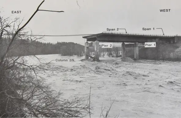
"Schoharie Bridge Collapse Looking south over bridge approx. 4 hours after collapse. Source: New York State Thruway Authority"

uticaod. photo by Utica resident Toni DiMeo
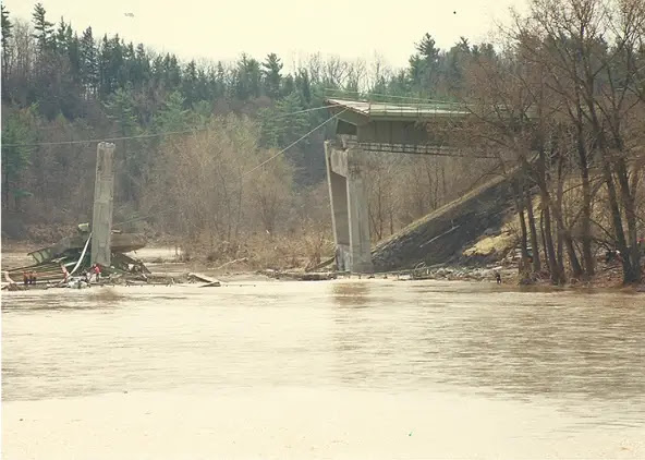
[This shows the slope failure under the north side of the west abutment. And the erosion down by the river that caused that failure.]

uticaod. photo by Utica resident Toni DiMeo

The flood was the result of the double whammy of snow melt and an intense Spring rain. The normally 6' deep Schoharie Creek was 25' deep. The first span fell around 10:45am. Another span dropped about 1:15pm. [DailyGazette, paycount 2]

Four cars and one truck fell 84' into the creek. "The cause was determined to be a failure to properly design, build and maintain the bridge. Built in the 1950s, the bridge's supports had concrete footings dug 6 feet into the riverbed, instead of piles driven into the bedrock needed because the riverbed soil was vulnerable to washing away." [TimesUnion]

"A rebuilt bridge was fully opened to traffic on May 21, 1988. The legacy of the tragedy was a reexamining of the way the state inspected its bridges. A Federal Highway Administration report fourteen months after the collapse found over two-thirds of New York State's bridges to be deficient, the highest percentage in the nation. The state took over examination of all bridges, including those owned by the Thruway Authority and local governments. 'It drew attention to the way that the bridges were inspected, to the degree of inspection and to the need for underwater inspection for piers and abutments,' John Seligman, director of infrastructure services for Spectra Engineering, told the Post-Standard in 2007." [syracuse]

Since it took over a year to build a replacement bridge, a 1910 railroad bridge that was being used for a trail was converted to a road bridge in a couple of months to help handle the detour traffic on NY-5S. 

uticaod, Source: New York State Thruway Authority

I changed the order of these photos to try to put them in chronological order.
uticaod, Source: New York State Thruway Authority

uticaod, Source: New York State Thruway Authority

uticaod, Source: New York State Thruway Authority

uticaod, Source: New York State Thruway Authority

uticaod, Source: New York State Thruway Authority

uticaod, Source: New York State Thruway Authority

eng-resources, photo courtesy Howard F. Greenspan

I didn't bother reading the NTSB report because I found this report to be informative.
Some of my takeaways:
  • The scour hole under pier 3 was 9' (3m) deep and 25' to 30' (7.5m to 9m) long.
  • "The state also required diver inspections of the underwater structures every five years." But it had never been inspected in over three decades.
  • The design called for the sheet piles to be left in place and for the excavation to be backfilled with riprap. Instead, the piles were removed and the excavation was backfilled with erodible soil and topped off with some riprap.
  • A 1955 flood had probably removed the little riprap that had been placed by the pier.

Facebook Reel
I stopped watching when they started asking a police officer how hard was it to work here.


Wednesday, January 25, 2023

1934-1992 Ogden Avenue Viaduct over Goose Island

(Satellite)

Since I've researched the Ogden Bridge over the CB&Q tracks in Cicero, it is only fair that I note this viaduct over Goose Island. I've seen several photos of the bridge in Cicero because of railfans. In contrast, this is the first glimpse I have seen of the viaduct over Goose Island.
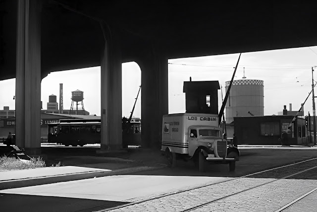
Jim Shortz posted
This one I can’t place. I don’t know of an Edward Hines Lumberyard in the area.
Bob Lalich: This is Halsted and Division on the near NW Side.

Dennis DeBruler commented on Jim's post
This is the first photo that I remember seeing that gives a glimpse of the Ogden Avenue viaduct. I see Ogden used to go all the way to Lincoln Park.
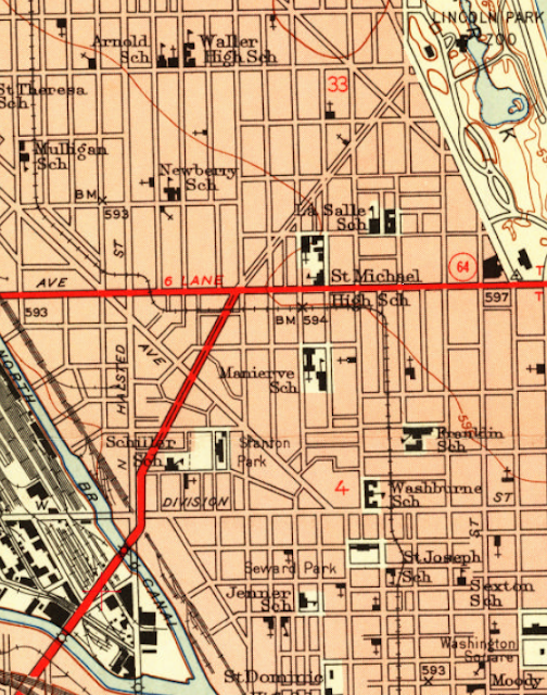
1953 Chicago Loop Quad @ 24,000

As we see on the above topo map, Ogden also had drawbridges on both sides of the island.
Chicago River Bridges Book by Patrick T. McBriarty via Bridge Hunter, License: Creative Commons Attribution-NoDerivs (CC BY-ND)

I finally came across a photo of one of those drawbridges.
Jerry Ramirez posted
The old Ogden bridge! It also cross Cabrini Green housing ! You also had a great view of the downtown skyline.
 
David H. Nelson posted
David Daruszka: The C&NW main line is on the lower left. The tracks above it led to the C&NW's Erie Street Coach yard.
David H. Nelson: Yes. That's (Correction-->) Halstead Ave running along the right edge of the photo so the camera is looking almost due north.

David H. Nelson posted two photos with the comment: "I found an old photo of the Odgen Overpass of Goose Island, where the MILW had their Division St Yard.  A pal ran it thru an AI upscaler making it 4x larger and sharpening it as well. Here are the before and after images (be sure to click on each image to get the full size.  The differences are quite apparent then)."
Chris Jansen: You should post the upscaled somewhere and link to it cause FB's compression is undoing half of that work.
1

2 [This is the photo that he used in his first post.]

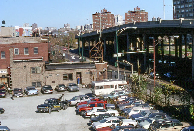
One of a few photos of the viaduct by David Wilson in his Nov 1990 Album
19901117 13 Halsted St. @ Division St.
Juni Salsero Hernandez posted
Ogden Viaduct at Division & Halsted back in 1990. This is true Chicago history of one of the best structures ever built by the city of Chicago back in 1934. Too bad, it wasn't ridden enough to keep!
Lee Kanne: Ogden ran all the way to Armitage and Clark. Through Old Town. You can still see big spaces between buildings in Old Town where Ogden was.

I found several photos taken from the viaduct rather than of the viaduct. See Forgotten Chicago for more information about the extension and removal of Ogden.

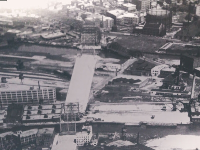
One source said you could not access the island from the viaduct. But this photo and the historical aerial photo below show that there was a ramp that went down to Hickory Avenue. I think the gasometer in the photo at the top of these notes is the one that is about a block south of Division Street between Crosby and Kingsbury Streets.
1938 Aerial Photo from ILHAP

It is in the background of this aerial.
David Janin posted
Goose island,  Chicago  another Milwaukee road news bureau pic  60s anyone ?? Think I see a S2 3 alco switcher???
Dennis DeBruler shared
Milwaukee's Chicago & Evanston branch used to have a big presence on Goose Island.
Jeff James: What a great show - did not realize how much of the island was covered in the rail yard and love seeing the old ogden bridge
Dennis DeBruler: Jeff James Thanks for pointing out the Ogden Viaduct. I had missed that.
Andy Hughes: All that and the 600 ft cement boats using the turning basin on the right.

A nice aerial view of the viaduct behind a lot of copyright issues.

Tuesday, January 24, 2023

8 Locomotives on KNWA/NS/N&W/Virginian Lefthand Fork Paint Creek Bridge over Sweeneysburg Rd. north of Harper, WV

(Bridge Hunter; no Historic Bridges; Satellite)

Street View, Sep 2021

I Love Trains posted
photo courtesy of Shane Alexander · 8 locomotives from Kanawha River Railroad pulling coal cars across the Sweeneysburg Trestle along the former Deepwater Railway near Harper, WV.
[I was struck that 8 locomotives on the headend would pull a lot of couplers. Some others also thought that. I've seen BNSF intermodal trains with 5 locomotives on the head end. But someone explained that one of them is a spare because parts of the route are on the tracks of another company. This Winter (2023), BNSF has been running 4 on the front and 2 on the rear. They use more locomotives in the Winter than they do in the Summer.]
Brandon Donell: I live 2 tenths of a mile from this train trestle. This is a steep incline with all 100 to 110 cars full of coal. Most of the time they run 4 engines pulling and 3 pushing. The it's a awesome sight to see!
Richard Cramer: As a federal licensed locomotive engineer, there’s no way EIGHT locomotives are “PULLING” that train. Even at 2,000 a piece they would be way over powered for knuckle strength on the head end of that train.
At one time the railroads didn’t have a maximum power limit. They all do now ! That’s why when they require more power not allowed ON THE HEAD END. They use remotes in the middle and or pushers on the rear. Some manned, some remote.  Usually 3 six axle 3,000 horsepower units on the head end is the maximum. They even have restrictions on how many axles can be using dynamic brake.
Andy Babin: Richard Cramer "3 six axle 3000hp units max on head end"
Whose railroad, what part of the country? Please post regulations. We regularly see 3-5 4000+hp jacks on the head end of mixed freight and stack trains on the KCS in south Texas. Same often seen in central and west Texas. All pulling or braking. No cold potatoes or isolated units.
Richard Cramer: Andy Babin . Time tables are very specific for the divisions they are applicable on. I can only relate what the rules and special instructions were in force on our specific division and sub-districts. Funny you wouldn’t know that. If you are an engineer you should. If you run with that much head end power, good for you. Get a knuckle on one of our trains with more than 3 six axle unites on line, you’re having a train handling violation formal investigation. I can only speak for my railroad and it’s Lake Division. Same way with unit’s with extended range dynamic brake. You may have to cut out dynamic brake or cut out some traction motors to comply with our train handling rules.
Every broken knuckle on any of our trains are inspected by a supervisor and you better hope it was an old brake. Or they will down load the event recorder and go from there. The NS loves to give out street time and then wonder why they don’t have people to operate their trains.
Andy Babin: Richard Cramer Interesting that now it applies to specific divisions and sub districts.

Ken Lewis Flickr, 2016 via BridgeHunter
UP on NS @ Sweeneysburg, WV.
S/B NS U79 at Sweeneysburg, WV.
 
Soutwest Virginia Rails posted
Here’s one of my favorite shots from yesterdays trip to new territories. A Kanawha River Railroad (KNWA) empty coal train soars over the Sweeneysburg trestle and over top of Sweeneysburg Road. I was hoping for one of those six ex-NS SD60’s to lead, but beggars can’t be choosers and had to settle with an NS DC GEVO in the lead. This photo was taken between Sweeneysburg and Beckley, WV.
 7-24-2023
Mike Mullins: The 60’s were overdue for a date with the fuel rack - otherwise I may have put one in the lead. Thanks for coming out. You guys kept my conductor and I entertained the whole trip.

WATCO has been operating this route since 2016. "Watco took over operations from Norfolk Southern. Their new territory encompasses the former New York Central between Columbus, Ohio and Dickinson, WV and the former Virginian between Dickinson and Elmore, WV. This new operation is called the Kanawha River Railroad (KNWA)." [Trainorder]
WATCO

Street View, Jun 2021

I wonder what percentage of the viaducts in the US are curved.

1965 Eccles Quad @ 24,000


Brightline+FEC over Turkey Creek in Palm Bay, FL

(no Bridge Hunter; Satellite)

These notes show the construction of the second bridge for a second track.

Street View, Sep 2022

The blue yellow and blue girders above are for the temporary work trestle. The crane is reaching over the current right-of-way. This is what the bridge normally looks like.
Street View, May 2021

I was going to simply add this as a bonus to the Sebastian river notes. But then I noticed that this one was the last girder for the whole Brightline project. But more significantly, I noticed the mix of using steel and concrete girders.
safe_image for Brightline Construction: Final Girder Installation at Turkey Creek - January 20, 2023
This GoBrightline construction update looks at the installation of the final girder at the Turkey Creek bridge in Palm Bay, FL. In addition to being the final girder at this bridge, it is also the last of 108 total girders required as part of Brightline's Orlando expansion. 

The Roaming Railfan confirmed that a steel beam is used to span the navigation channel while concrete beams are used for the other spans. This taught me that steel beams are stronger than concrete beams. Not only is the steel beam longer, it is not as deep. But I'm sure steel is more expensive or we would never see the use of concrete beams.
8:08 video @ 0:00

This was the satellite image I accessed. I was confused because it looks like there already is a second bridge.
Satellite

So I fired up Google Earth. The above image was taken Jan 2021. This later image shows that they evidently removed a steel bridge to replace it with this new bridge.
Google Earth, Jan 2022


Monday, January 23, 2023

Johnstown Inclined Plane (Funicular) in Westmont, PA at Johnstown, PA

(Satellite, 2080 photos!)

Johnstown was hemmed in by the mountains, which restricted the growth of the steel industry. To provide more room for homes for employees, Cambria Iron Company, a predecessor of Bethlehem, opened this incline on Jun 1, 1891. "For over 40 years it served as a safe and sure link to the community situated on the rim of the hill overlooking Johnstown. Because of the convenience and access to the heart of the business district, it was directly responsible for Westmont becoming one of the nation's earliest residential suburbs." [JohnstownPA]
 
Jackson-Township historical preservation posted
The Johnstown Inclined Plane was built after the Johnstown flood of 1889. The Inclined Plane's original purpose was to connect Downtown with the higher grounds of Westmont Borough in order to develop that area residentially. During Johnstown's two other floods in 1936 and 1977, the Incline became a lifesaver, helping people to escape downtown as well as to ship supplies into the valley. In its heyday, the Incline carried approximately 1,000,000 passengers a year to and from the downtown area. This was largely due to the Steel Mills that were in operation. The Johnstown Inclined Plane is the steepest vehicular incline in the world, meaning its 30' cars, which are large enough to hold 60 people, 6 motorcycles, or a vehicle, travel at the steepest grade for cars their size.

Paul Zeller commented on the above post

Paul Zeller commented on the above post

𝗥𝗲𝗺𝗲𝗺𝗯𝗲𝗿 𝗪𝗵𝗲𝗻: 𝗣𝗲𝗻𝗻𝘀𝘆𝗹𝘃𝗮𝗻𝗶𝗮 posted
Johnstown Inclined Plane, West side of Stony Creek!
📸 • LOC 
Comments on the above 2025 post

1 of the 48 images shared by James Smith in an album by Jackson-Township historical preservation
Close-up view of the Inclined Plane, looking from Downtown Johnstown towards Westmont Borough in 1950. This historic transit facility travels upward on a 71% grade to 1693. At 5 feet above sea levelm, 38-ton cars are pulled by a 2" cable, 1175 feet long, and tested to 396,000 pounds, wound on a 16 foot diameter drum driven by 400 HP electric motor. 85-pound steel rails are supported by 720 wolmanized ties-12" x 12" x 14'. There are 45 Steel girders on 16 cement pilasters. The Inclined Plane contains 50.4 tons of U.S. made steel and is lit by 114 sodium lights. The Inclined Plane was built in 1890 and was historically restored in 1984. The owner is the Cambria County Transit Authority. 

1 of the 48 images shared by James Smith in an album by Jackson-Township historical preservation
The Johnstown Inclined Plane was built after the Johnstown flood of 1889. The Inclined Plane's original purpose was to connect Downtown with the higher grounds of Westmont Borough in order to develop that area residentially. During Johnstown's two other floods in 1936 and 1977, the Incline became a lifesaver, helping people to escape downtown as well as to ship supplies into the valley. In its heyday, the Incline carried approximately 1,000,000 passengers a year to and from the downtown area. This was largely due to the Steel Mills that were in operation. The Johnstown Inclined Plane is the steepest vehicular incline in the world, meaning its 30' cars, which are large enough to hold 60 people, 6 motorcycles, or a vehicle, travel at the steepest grade for cars their size.
(Text from http://www.inclinedplane.org/)
 
Jackson-Township historical preservation posted
Wagon approaching the Inclined Plane in Downtown Johnstown in 1910.

Ditch Light Productions posted
Eastbound Norfolk Southern Manifest traversing the Pittsburgh Line through Johnstown, PA.
This was a shot that I’ve been wanting to check off my list for a while. It was inspired by a shot Dan Davis got of an eastbound Pennsylvanian.
@topfans
Dennis DeBruler: And a nice view of the inclined plane.

It looks like this is a favorite location of railfans.
Rusted Rails Photography posted
Amtrak 42 speeding out of Johnstown’s station around what i refer to my self as “Rock-face Bend” I’m sure it has a real name, but I don’t know it. Despite the temperature being just above freezing wildlife was out along the Conemaugh river. The clouds decided to open up just enough for the train to be the focus.
 
David Heny posted
Featured Trail Town – Johnstown, Pennsylvania — ATRA

This photo shows how the mills were shoehorned between the hills and the river and why the town had to grow on top of a hill. Although this incline went up the hill that is out-of-frame to the left.
Aaron M. Vedock posted
Johnstown, PA - photo taken in December 2019
Viktor Mácha: And some pictures from the inside:
https://www.viktormacha.com/galerie/gautier-steel-johnstown-305/

Chairs Lion posted
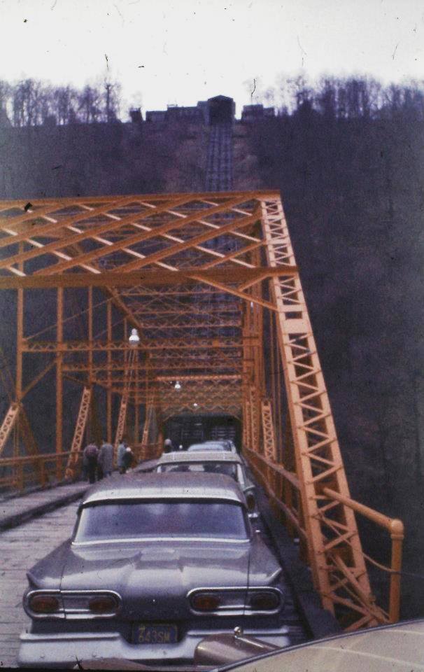
View of Downtown Johnstown from the Incline Plane in Westmont in August of 1967.
(Photo from George Vorhauer)

At one vehicle per trip, it is going to take a while to work through this queue.
1 of the 48 images shared by James Smith in an album by Jackson-Township historical preservation
Cars waiting to travel up the Incline Plane from Downtown Johnstown to Westmont on December 21, 1960.
(Photo from Marlin Miller via https://www.facebook.com/groups/2227082563)

1 of the 48 images shared by James Smith in an album by Jackson-Township historical preservation
Engineering drawings of cars used on the Johnstown Inclined Plane. The Johnstown Inclined Plane was built after the Johnstown flood of 1889. The Inclined Plane's original purpose was to connect Downtown with the higher grounds of Westmont Borough in order to develop that area residentially. 
(Photo from https://www.facebook.com/theJAHA/

1 of the 48 images shared by James Smith in an album by Jackson-Township historical preservation
Facts about the Inclined Plane in Johnstown. This historic transit facility travels upward on a 71% grade to 1693.5 feet above sea level. 38-ton cars are pulled by 2" cable, 1175 feet long, tested to 396,000 pounds, wound on 16 foot diameter drum driven by 400 HP electric motor. 85-pound steel rails supported by 720 wolmanized ties-12" x 12" x 14'. 45 Steel girders on 16 cement pilasters. Contains 50.4 tons of U.S. made steel. 114 sodium lights. Built in 1890. Historically restored in 1984. Owner: Cambria County Transit Authority.

1 of the 48 images shared by James Smith in an album by Jackson-Township historical preservation
Johnstown Incline Plane in 1926. The Incline Plane is 985 feet high according to this vintage postcard. 

1 of the 48 images shared by James Smith in an album by Jackson-Township historical preservation
Interior view of the building housing the drive wheel and cables for the Inclined Plane in Johnstown.

Originally, it was steam powered.
1 of the 48 images shared by James Smith in an album by Jackson-Township historical preservation
The inside of the Engine Room at the Johnstown Incline Plane around 1910.
(Photo from http://johnstownhistory.blogspot.com/)

Shyanne Templeton (Shyshy), Nov 2020

InclinedPlane
It was closed in Feb 2022 for rehabilitation. It is expected (as of Jan 2023) to open in late Spring, 2023. [It had been rebuilt in 1983. [pabook]]

More of the 48 images shared by James Smith in an album by Jackson-Township historical preservation.
a
Cambria Incline Plane from Downtown Johnstown in 1908.

b
Old postcard showing the Incline Plane from Downtown Johnstown looking towards Westmont in 1912.

c
Scene from the top of the Inclined Plane in Johnstown.

d
James Lehman: A good view of the lower level of a car. It must have been small.
Don Wirick: James Lehman it held 12 passengers.

The lower room was removed rather soon because 12 extra passengers was not significant.
e
Beautiful fall colors surround the world famous Johnstown Incline Plane looking up from Downtown Johnstown towards Westmont in Cambria County in the 1960's.

Phil Jadlowiec posted
Sharing from another person

Phil Jad posted
Sharing from another group/person
Tim Olshewsky: Just like yesterday. E Furnace - Mag furnace

Facebook Reel
It can carry cars as well as passengers. It is advertised as the world's steepest vehicular inclined plane. The grade is 71.9%.