Friday, November 24, 2023

1935-2016+1991+2015 I-64+US-40+US-61 Daniel Boone Bridge over Missouri River at Chesterfield, MO

(Bridge Hunter broke Mar 22, 2023; Historic Bridges; John A Week III; Satellite, 107 photos)

US-40 Overview

"This bridge was a rare example of a riveted continuous through truss. It was particularly uncommon because it had four main spans, but they were configured as two two-span continuous truss bridge components. As a result, if the placement of piers is ignored, the bridge looks like it has two spans, instead of four." [HistoricBridges]

Street View, May 2019

The new bridge obviously uses steel girders. I chose the transition from approach spans to main spans to show how deep the girders are. The main span girders look about as tall as a simi-truck trailer.
Street View, Jun 2023

If I go back to 2013, the old span is still standing.
Street View, Jun 2013

alberici
The new bridge replaced the 1935 bridge and cost $113m. The crossing handles "80,000 daily travelers."

alberici
"The new bridge measures 2,615 feet [800m] with a main navigational span of 510 feet [155m], making it the longest parallel flange plate girder bridge ever built over the Missouri River....Its deep-water foundations are designed to resist seismic events and barge impacts, even during major floods."

John is headed westbound in 2008.
John Weeks

alberici
"The bridge also includes a separate 10-foot-[3m] wide shared-use path that connects two popular recreational trails on either side of the river. It is designed to protect cyclists and pedestrians from interstate traffic and features pedestrian overlooks that offer a scenic view of the river below."

alberici

alberici
It uses weathering steel.

AmericaTransportationAwards
This source puts the cost at $114.5m.

RoadTraffic, Credit: MDOT
The second truss bridge is also a continuous truss. "The new bridge has a minimum expected lifespan of 100 years."

MDOT

A Google search showed three videos of the demolition. I didn't bother watching them. I agree with Historic Bridges, a bridge that was good enough to carry interstate traffic could carry non-vehicular traffic for many more decades. And that would have saved the expense of adding the 10' (3m) non-vehicular lane to the new bridge.

Randall Perkinson Photography posted three photos with the comment:
Daniel Boone Bridge 
I-64 over the Missouri River
Saint Louis County/Saint Charles County, Missouri
This pair of bridges includes a truss bridge (WB I-64) and a plate girder bridge (EB I-64).  The river is currently above flood stage from all the upstream rain over the last few weeks.  The original truss bridge was removed following completion of the new eastbound plate girder bridge.
1

2

3

Randall Perkinson Photography posted three photos with the comment:
Truss Connections
Westbound Daniel Boone Bridge over the Missouri River 
Saint Louis County/Saint Charles County, Missouri 
I love symmetry of a truss bridge and patterns of the bolts at the connections.
1

2

3


Thursday, November 23, 2023

2014 Penang Second Bridge, Malaysia

(Satellite)

"The Sultan Abdul Halim Mu'adzam Shah Bridge (E28), popularly called the Second Penang Bridge (or Penang Second Bridge), is a bridge linking Penang Island to Penang Mainland. It is 24 km (15 miles) in length, with length over water of 16.9 km (10.5 miles). Its length over water is double that of the first Penang Bridge. Since its completion, it is the longest bridge in Malaysia. The Second Penang Bridge was officially opened to the public at around 12:01 am in the morning of 2 March, 2014. It was renamed by Prime Minister Datuk Seri Najib Tun Razak after Tuanku Abdul Halim Muadzam Shah, the Sultan of Kedah and the reigning Yang di-Pertuan Agong of Malaysia at the time of its inauguration." (18:54 video) [TravelTips]

redupper and gssb

Highway Engineering Discoveries posted
New Second Penang Bridge ,Malaysia
The project team gave the second bridge several S-shaped curves along its 24km length. This was intended to keep motorists' attention on the road while driving and reduce accidents. The second bridge has seismic expansion joints – allowing the structure to move during an earthquake.
Highway Engineering Discoveries posted without the arrow
 
RoadTraffic
"Similar to the first Penang bridge, the Penang Second Bridge has a cable-stayed, mid-span of 240m [787'] and a clearance height of 30m [98'] above sea level. A dual-pylon, cable-stayed structure consisting of three spans was adopted for the main navigation spans. The high clearance allows large ships to pass under the bridge." The total cost was $1.37m, which was largely funded by China.

30m (98') is not a high clearance. The 1931 Bayonne Bridge was built with a clearance of 151' (46m). But a major project in the 21st Century increased that clearance to 215' (65m). And the St. Lawrence Seaway, which is now rather old, has a clearance of 151' (46m).

mageba-group
"All TENSA-MODULAR expansion joints are designed with a special seismic protection feature which allows transverse movements of up to 200 mm. Four of the TENSA-MODULAR expansion joints are Type LR-LS (featuring noise reducing surface plates), especially suitable for locations close to residential areas."


Wednesday, November 22, 2023

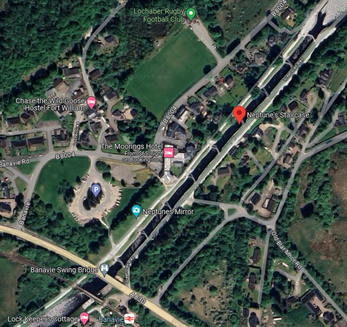
Neptune's Staircase Locks and bobtail bridges on Caledonian Canal near Fort William, Scotland

(Satellite, 7,716 photos)

AtlasObscura, AEROID / CC BY-SA 3.0

For  the love of Narrowboats posted
Neptune's Staircase...
Neptune's Staircase  is a staircase lock comprising eight locks on the Caledonian Canal.
Built by Thomas Telford between 1803 and 1822, it is the longest staircase lock in Britain. The system was originally hand-powered but has been converted to hydraulic operation.
The current lock gates weigh 22 tons each, and require a team of at least three lock-keepers to operate the staircase. They usually operate on an "efficiency basis"; that is, they try either to fill each cut with ascending boats or with descending boats, or to allow for passing, i.e. a dropping craft to pass a rising craft on the same fill/empty cycle.
image credit... Pierre Lesage

Satellite

BritainExpress
"Neptune's Staircase is a series of 8 locks on the Caledonian Canal...The locks were designed by the famous Scottish engineer Thomas Telford and made to handle a change in elevation of 64 feet (19.5m). It is the longest staircase lock in Britain at over a quarter-mile in length (447m) and takes boats about 90 minutes to navigate from top to bottom (or vice-versa). The Staircase took 19 years to build, starting in 1803 and ending in 1822....Telford's design called for a depth of 20 feet (9m) but in the name of cutting costs, the actual finished depth was just 14 feet (roughly 4.5m). This cost-cutting proved shortsighted, as the shallow depth meant that the canal was unusable by most of the large ships being built when the canal was opened....The Caledonian Canal spans the Great Glen, linking Fort William to Inverness. It was designed by Telford to ease boat transport at a time when the Napoleonic Wars threatened British shipping. By travelling up the Canal boats could forego the dangerous trip around the north of Scotland."

A view looking down the staircase. It is near the southern end of the canal.
ScottishCanals

Street View, Jun 2017

The above street view was taken from a bobtail bridge. Note that the railroad bridge is also a bobtail bridge.
Satellite

A video of that bridge opening up.
barry watt, Oct 2023

The railroad bridge is also worth noting.
Street View, Mar 2023

I'm goint to "park" this 2;59 video about the Great Glen fault here for now. I assume this is the "straight line" on which the Caledonian Canal was built.


Tuesday, November 21, 2023

Trail/Western Maryland Bridge over Potomac River near Little Orleans, MD

(Bridge Hunter broke Mar 22, 2023; Satellite)

Edward O Pollock III posted two photos with the comment: "Former Western Maryland over the Potomac River near Kasecamp Rd.  Even with a Toyota 4-Runner it is not easy to get here."
Joe C Rainwater: Cool. This is out past Little Orleans. It is in Green Ridge State Forest. Other tunnels and bridges are in the area and somewhat accessible.
1

2

Dennis DeBruler commented Joe's comment
Joe C Rainwater: Dennis DeBruler that should be it.

It is the northernmost (top) of these six bridges.
Andrew Coblentz commented on Andrew's post
One of 6 crossing the Potomac.

Jason Odom posted two photos with the comment: "Western Maryland Railroad, Little Orleans MD."
Anthony Migliaccio: Nick Martin Abandoned in 1975, rails ties and ballast removed over the next year or two. ROW between Sidling Hill and North Branch acquired by the National Park Service in 1981 as part of the C&O Canal NHP. ROW and tunnels now wildlife refuge.: This section went through the legal abandonment process with the Interstate Commerce Commission in the 1970s.
NPS has utilized the tunnels of this section as bat rookeries. There are currently no plans in the worksto use the WM ROW between the C&O Canal Paw Paw Tunnel parking lot and Sidling as a trail. The east and west end of the current trails are connected to the C&O canal tow path which is maintained.
Keith Seavolt: Lots of it is obliterated. Road widening on MD 51, there's a power plant sitting atop the old ROW, and the line passes under the Cumberland airport via tunnel and if I recall correctly the FAA made them bury it when the airport expanded and added a runway.
Tim Shanahan shared
1

2


Monday, November 20, 2023

Trail/B&O/Hempfield Railroad 1857 Viaduct and 1904 Tunnel Green in Wheeling, WV

Viaduct: (Bridge Hunter broke Mar 22, 2023; Historic Bridges; HAER; Satellite)
Tunnel: (see below for satellite information)

The stone viaduct is curved. The bridge was built in 1857, but the current tunnel was built in 1904. [HistoricBridges] 
Actually, the tunnel was also built in 1857, but a second track was added in 1904.


Street View, Aug 2023

The east end of the viaduct connects to the west portal of the tunnel.
Satellite + Paint
HAER WVA,35-WHEEL,52--1
1. View of viaduct and tunnel entrance from the northwest. - Hempfield Viaduct & Tunnel No. 1, Spanning Wheeling Creek at B&O Railroad tracks near I-70, Wheeling, Ohio County, WV
 
OhioCountyLibrary, 1 of 2 postcards and HistoricBridges
"The Tunnel Green Viaduct (designed by Suspension Bridge engineer, Charles Ellet, Jr.) spans Wheeling Creek after the Hempfield Tunnel at Tunnel Green. Wetzel's Cave is nearby."
 
Ohio County Public Library Flickr
Peninsula (Hempfield) Tunnel & Viaduct
Designed by Suspension Bridge engineer, Charles Ellet, Jr., the Hempfield viaduct railroad bridge spanning Wheeling Creek was built in 1853. On Oct. 4, 1853, the Wheeling Intelligencer newspaper reported: "The bridge across the creek on section 1, (the section which enters this city,) under the superintendence of Messrs. Otterson [superintendent of the stonework on the Suspension Bridge] & McCarty is assuming a shape that promises its early completion. It will consist of five spans of 45 feet each and will be a very substantial structure. The excavation preparatory to commencing the tunnel through Steenrod's Peninsula is also progressing rapidly."
The Hempfield Railroad, chartered May 15, 1850, was a line that originally was to run from Wheeling, West Virginia to Greensburg, Pennsylvania, a distance of 76 miles. In 1857, the railroad operated from to Washington, Pennsylvania, a distance of 32 miles. The line was bought by the Baltimore & Ohio Railroad May 1, 1871. The B&O RR operated on this stretch until the line was abandoned in 1973. It is now a part of the Wheeling Heritage Bike Trails.
- image from "Souvenir History of Wheeling", Philadelphia: Pictorial Publishing, 1906, Ohio County Public Library Archives
➤ Visit the Library's Wheeling History website
The photos on the Ohio County Public Library's Flickr site may be freely used by non-commercial entities for educational and/or research purposes as long as credit is given to the "Ohio County Public Library Archives, Wheeling WV." These photos may not be reproduced in any format for profit or other presentation without the permission of the Ohio County Public Library.
➤ Contact the Ohio County Public Library to request permission for use or publication of materials.

Ivan Safyan Abrams Flickr
The Chessie Steam Special crossing Wheeling Creek, eastbound, Wheeling, WV, 1978

The Odd and Amazing World added three photos with the comment: "Hempsfield tunnel Wheeling Wv. Said to be haunted."
The Odd and Amazing World shared with the comment: "Apparently this tunnel connected to the abandoned tunnels in Washington Pa?"
Tom Donathan: Yes. Line ran from Wheeling to Washington mostly alongside US 40 National Rd.
Erik D. Neely: The lost portion of the Peninsular Cemetery above is haunted. Stories just merged with the tunnel. Same with the Green Ooze that supposedly drips from the ceiling.
[I read that some of the graves in the cemetery were relocated and "robbed" during the construction.]
Jim Hufschmitt: Is this the tunnel locals called Tinnel Green?
Dennis DeBruler: Jim Hufschmitt It is called "Tunnel Green" by some sources. https://www.ohiocountylibrary.org/history/5238 See Erik's comment about "Green Ooze."
1
[Because of the railings, this is obviously the west portal.]

2
[This must be the east portal.]
Sheridan Parsons V: WHERE IS THIS??
Dennis DeBruler: Sheridan Parsons East Portal: https://maps.app.goo.gl/J28UaG6MzQbzGQLu6

3

Molly George, May 2020

Given the construction date, the leaders of Washington, PA, probably pushed the railroad to the Ohio River because back then the waterways were the transportation arteries of the nation.
1951 Canton Quad @ 250,000

Dave Kuntz posted four photos with the comment:
1

2

3

4

Kodi Milhoan commented on Dave's post
Photo by JJ Young Jr

Kodi Milhoan commented on Dave's post
Photo by JJ Young Jr

Facebook Reel

Facebook Reel
lll

LStraubB posted
🤩 1857 Hempfield Tunnel / Tunnel Green
Wheeling WV
Ohio County
"The tunnel is 448' (137m) long."

Howard Itsnotme commented on LStaubB's post, cropped


More about the trail: wvrailtrails and WheelingHeritageTrail

5:29 "exploration video"   I did not watch it.