Monday, October 28, 2024

1892 CSX/Western Maryland Bridge over Potomac River near Cherry Run, WV

(no Archived Bridge Hunter; no Historic Bridges; Satellite)

I could not find a photo of the current bridge.

Metrotrails added
Historic image of the original 1892 Western Maryland Railway bridge over the Potomac River, built to connect with the Baltimore and Ohio before the Western Subdivision to Cumberland was completed in
1906.

The bridge is at the bottom of of this map excerpt.
1951/53 Cherry Run Quad @ 24,000

The bridge is near the upper-left corner of this excerpt. I presume orange is CSX.
OpenRailwayMap

Sunday, October 27, 2024

1880,1990s,2014 Houck Covered Bridge over Big Walnut Creek in Putnam County, IN

(Satellite, 151 photos)

PutnamParks
This 201' (61m) long bridge was bypassed in 2014 to allow pedestrian traffic on the bridge.

D, May 2022

Amy Dawn Whitlock, Aug 2019

Paul's Scanner posted
Putnam County Highway working hard to preserve a beautiful Covered Bridge. Houck CB in Putnam County.

JohnLobban, 1 of many photos in an album concerning the restoration
The siding from a recent preservation effort was falling off already.

1963+2020s US-212 Bridges Over Yellowstone River in Yellowstone National Park, WY

(Satellite)\

The new 1,285' (392m) long bridge is 175' (53m) high and is expected to cost $118m. The 1963 bridge was 604' (184m). It is on the only road in the park that is plowed for winter use. [MyBigHornBasin]

Oct 2024:
Yellowstone National Park posted three photos with the comment:
What’s up with all the construction in Yellowstone?
With over 4.5 million visits to the park each year, our park roads and facilities receive a lot of wear and tear. Additionally, our window to do most of the maintenance and improvements happens during a short summer season.
Currently, one of the largest infrastructure improvement projects happening in the park is the replacement of the Yellowstone River Bridge. Located on the Northeast Entrance Road near Tower Junction, the original bridge from 1963 will be replaced with a brand-new bridge on a new alignment. The new bridge will be 1,175 feet long and 162 feet high, stretching over the Yellowstone River below. We are also expanding the Yellowstone River Picnic Area and overlook parking areas. This huge project, funded by the #GreatAmericanOutdoorsAct, is slated to be finished sometime in 2026!
Our goal is to keep Yellowstone in good shape for you and future generations. Learn more about the variety of infrastructure improvement projects occurring throughout the park at: go.nps.gov/YELLinfrastructure
Kevin Buck: What's next, an interstate highway through YNP with exits at all the major attractions? Where should we build a Wal-Mart with a massive parking lot?
1

2

3

Douglas Rogers commented on the above post
Earlier this summer. Very impressive !

Michell Tuck commented on the above post
Pretty impressive! Took this a few weeks ago [Sep 2024] during our visit.
Robert Wolff: Michell Tuck Seriously, a bridge pillar on the outside turn of the river. Hope the footing of that pillar are deep, deep, deep. It would have been wiser to put the new bridge right next to the old bridge.

According to the comments on the post, they plan is to remove the old bridge and highway. So what will the bison use to get across the river?
Caren Walker commented on the above post, cropped
Yesterday’s (10/7[2024]) action on the old bridge.

Caren's comment was a video and this is another screenshot, cropped

I wonder how much extra it cost to build a bluff-to-bluff bridge rather than continue to go down and hill and back up on the other side.
1986/86 Tower Junction Quad @ 24,000

The current bridge.
nps, NPS/Doug Madsen

usgs

The replacement bridge, Nov 2025:
Casey Karren posted two photos with the comment: "Here’s a Bridge we just finished building in Yellowstone 😊"
Theron Stratton: look like pretty long spans for steel girder
Casey Karren: Theron Stratton just a little over 1200’ [366m] and about 40,000 bolts 😩
1

2

Saturday, October 26, 2024

Abandoned/MRL/NP 2022 Flooded Bridge over Yellowstone River near Livingston, MT

 (Archived Bridge HunterSatellite)

We already saw in Reed Point, MT, that the Yellowstone River inundated its flood plain, covered a main highway and threatened the town.

A Flickr photo showing the flood waters while the bridge was still intact.

"Built 1897, Relocated here 1918" It was damaged in the Spring of 2022 and removed in Aug 2022. The longest span in this 316' (96m) bridge was 155' (47m). [BridgeHunter]

Thomas Wentzel posted two photos with the comment: "A collapsed train bridge is shown along the Yellowstone River Wednesday, June 15, 2022, near Livingston, Mont."
1

2

A reference on BridgeHunter indicates it was this bridge by MT-89.
Street View

Street View, Oct 2021

Street View, Aug 2022

Street View, Aug 2024

The bridge was pin-connected.
Street View, Oct 2021

At least the highway bridge survived the flood.
Kyle, Nov 2022

Global Earth, Sep 2020

I am surprised that it eroded on the inside of the bend in the river. The current is normally stronger on the outside shore of a bend and that is normally where the erosion happens.
Global Earth, Jun 2022

Global Earth, Dec 2022

Bonus


The flood also took out a road bridge in Yellowstone National Park.
0:54 video

Friday, October 25, 2024

1973 I-95 Girard Point Bridge over Schuylkill River in Philadelphia, PA

(Broken Archived Bridge Hunter, no Historic Bridges, B&TSatellite, 165 photos)

Street View, Apr 2023

Google Search Results

Street View, Jul 2024
;;
Street View, Jul 2024

Street View, May 2022
 
It handles 148,500 vehicles per day, of which about 6% are trucks. It "is nearly a mile long (5,183 feet [1.6km])" [PennDOT]

The green bridge in the middle of this photo is the Basin Bridge. I discovered this I-95 bridge while looking for a street view of that bridge.
Bridges and Tunnels
The contract for the bridge was $33.2m and for each approach was $11.2m. Renovations done between 2010-12 cost $71m. There is some confusion about the length because this source specified 1.77 miles based on a 1976 newspaper article. (And this source specifies 4,921'.)

Google Search Results

Google Search Results

Once again, the Bridge Hunter link is broken so all I have is the index entry.
Bridge Hunter

"This is an interesting bridge and has an unusual design because FAA had maximum height requirements, the Coast Guard and Navy had minimum vertical clearance requirements and there was a need to keep the Bridge envelope as narrow as possible due environmentally sensitive areas surrounding the bridge." [HumanGyroscope comment on reddit]

The bridge has really long approaches to achieve the required minimum vertical clearance of 135' (41m).
LocationsHub

1942 Basin Bridge Road Bridge over Navy Yard in Philadelphia, PA

(Archived Bridge Hunter; no Historic Bridges; Satellite)

John Brady posted
Vertical lift bridge spanning the entrance to the Philadelphia Navy Yard’s Reserve Basin.
John Brady shared

Street View, Jul 2024
 
Street View, Apr 2023

On the left, I included a big gantry crane in the Navy Yard. The bridge in the right background is the I-95 Girard Point Bridge.
Street View, Nov 2016

Thursday, October 24, 2024

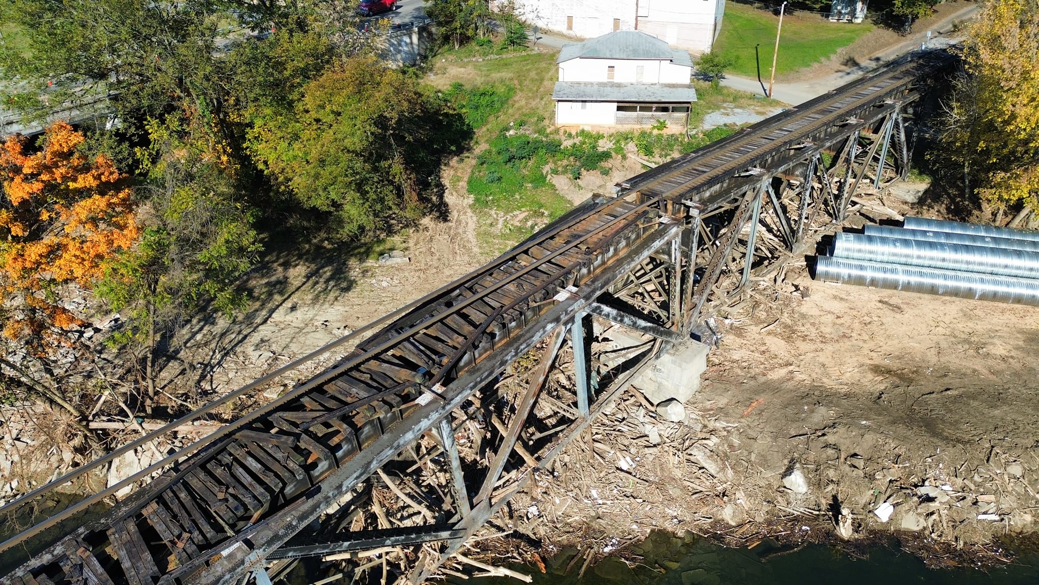
1916-2024 Collapsed/NS/Southern Bridge over Pigeon River at Newport, TN

(Archived Bridge Hunter; no Historic Bridges; Satellite)

Jonathan Hendrix posted seven photos with the comment: "The aftermath of Hurricane Helene continues to affect Newport, TN, where the trestle has given way, resulting in the rail hanging above the remnants."
[Some comments explain that workers had been evaluating the bridge before the collapse. Fortunately, no one was on it when it collapsed. Other comments discuss other problems on this NS route such as their railyard in Asheville flooded. Some comments agree that the bridge failure was probably caused by a pier failure due to scour. It never occurred to me that scour could cause a delayed failure until I saw this.]
1

2

3

4

5

6

7

Street View, Nov 2016

C Hanchey Flickr
NS Rwy Pigeon River Bridge (Newport, Tennessee)
Historic 1916 Southern Railway bridge over the Pigeon River in Newport, Tennessee. The bridge is a three-span Warren deck truss. The Southern Railway and the Norfolk and Western Railway joined in 1982 to become Norfolk Southern Railway (NS).

C Hanchey Flickr, same comment as above

Jacob Durham WVLT posted two photos with the comment:
The train trestle in Newport has collapsed this morning [Oct 23, 2024] causing several road closures in the area. The trestle was impacted by flood waters from Helene, the first photo was from October 8th and the second is from this morning. #wvlt
Top 📸: Matt Harmon
Bottom 📸: Newport Police Department
C Kent McKenzie shared with the comment: "The NS rail bridge at Newport, heavily damaged by the flooding from Helene, collapsed this morning, according to local news reports."
Christopher Love shared with the comment: "Newport, Tennessee."
Ross Church: The deck truss will probably be ok to reuse, just needs a new center pier.
R.B. Rail Photog shared
1

2

Victoria Kaminski commented on Jacob's post
I took this picture on September 30th. Same angle as the collapsed picture. They probably started removing debris and it collapsed.
Nikki Stokely: Victoria Kaminski it collapsed in the middle of the night..they had not been removing any debris yet

Mike Ray commented on Kent's share
better days

This would be one of the roads that was closed.
Street View, Jul 2021

Jonathan Hendrix posted four photos with the comment: "Current status of the bridge in Newport, Tennessee. Construction is advancing and workers were present on site today."
Greg Hale: Looks like they’re using the original short deck plate, and large span, on the one end?
Randall Hampton: Greg Hale I doubt that it's going to stay.
1

2

3

4


I assume that the non-Asheville scenes are of this bridge.
Norfolk Southern posted 10 photos with the comment:
One year ago today [Sep 26, 2025 so on Sep 26, 2024], Hurricane Helene brought historic flooding and devastation to much of Western NC and Eastern TN. 
In the days and months that followed, our railroaders, first responders, and local partners worked shoulder to shoulder to restore service safely and support those in need. 
Within 72 hours after the storm, our Engineering team safely cleared 15,000+ trees, repaired multiple washouts and slide fences, deployed 400+ generators, and reopened all affected mainline track—often working without commercial power. 
Five months later, Team NS and our contractors rebuilt the Newport rail bridge in Tennessee, restoring a vital link through the Blue Ridge Mountains. By April, the first non-revenue train rolled through Asheville. By May, customer freight was moving again. 
This summer, the Asheville team celebrated the opening of their brand-new crew room, replacing a space that had been destroyed in the storm. 
Each milestone is more than trains rolling or buildings and infrastructure rebuilt. It shows the grit, resilience, and determination of the people who keep this railroad running strong. 💪
There is still work to be done, including the restoration of the portion of the line that connects Old Fort to Grovestone through the historic Old Fort Loops. Team NS remains on the ground, committed to rebuilding stronger every day.  
🔗 Learn more at https://bit.ly/4mGisv0.
Randall Hampton shared
1

2

3

4

5

6

7

8

9

10

1:51  video via NorfolkSouthern

Nov 2025   I checked Street View, but it is still showing the old bridge.
This "slide show" of the replacement has some video footage. I found it interesting that they did not assemble the girders into spans while they were building the piles.
18:35 video @ 1:03