Tuesday, November 26, 2024

1894-1966+1966,2000 Glenwood Bridges over Monongahela River

1894 Bridge: (Archived Bridge Hunter)
1966 Bridge: (Archived Bridge Hunter; Historic Bridges; PGHbridges; Satellite)

 
Photo via BridgeHunter_1894, License: Creative Commons Attribution-Share-Alike (CC BY-SA)
Also, NewsInteractive, which has photos of the bridges along the Monongahela River.

This was a pin-connected bridge.
Jackson-Township historical preservation posted
Old Glenwood Bridge over the Monongahela River near the Hazelwood neighborhood of Pittsburgh.
(Photo from Blaine Stanziana via https://www.facebook.com/groups/132768683480072/)

The first photo must be of the north end because the bridge is curved and the separate truss in the foreground is going over railroad tracks. The second bridge must be of the south end.
Apr 17, 1948 @ 35,400; AR1DQ0000040080
.

1966 Bridge

 
HistoricBridges
This continuous truss bridge is 2,276' (694m) long with a 567' (173m) main span.

It has a vertical clearance of 50' (15m). [PGHbridges]

NewsInteractive, Credit: Post-Gazette
"The current Glenwood Bridge, which opened in 1966, is Pennsylvania's first all-welded, steel truss bridge."
 
"This bridge is unusual because most of the trusses are below deck except at the piers where they rise up forming a through truss design." [HistoricBridges]
Street View, Oct 2024


This photo has been moved to here.

This photo has been moved to here.


NS/Virginian Black Lick Trestle over Blacklick Creek near Princeton, WV

(Archived Bridge Hunter; no Historic Bridges; Satellite)

"Standing nearly 300' [91m] in the air and spanning 928' [383m], Black Lick Trestle remains as the highest trestle ever constructed on the former Virginian." [2013 photo]

"Intact but closed to all traffic; line embargoed in 2015." [BridgeHunter]

Street View, May 2024, looking North

Street View, May 2024, looking South

Stephen Preston posted
Black Lick Bridge on Virginian R.R. near Princeton, W. Va. c. 1910.

The trestle is near the upper-left corner of this map. I originally got a 1962 map, but the route was already labelled N&W. I looked it up, and the Virginian was abosorbed by the N&W in 1959.
1926/26 Bluefield Quad @ 62,500

Monday, November 25, 2024

Coralville Dam on Iowa River near Coralville, IA

(Satellite)

Street View, Oct 2015

USACE, Rock Island District posted two photos with the comment:
Today's edition of 'Then & Now' takes us over to Coralville Lake! The first photo, taken in 1957, shows construction of the dam and spillway. The area looks much different today as the reservoir has filled in to help with flood control in the area.
Coralville is one of three lakes/reservoirs in the District that help with flood control, in addition to two "dry" reservoirs we have as well!
1

2

USACE, Rock Island District posted
This week's #FlashbackFriday takes us to Coralville Lake just outside of Iowa City, Iowa. Dating back to 1957, this photo shows concrete work being done on the bridge leading to the control tower.
The dam at Coralville was completed in 1958 and regulates runoff from 3,084 square miles of land upstream providing flood protection to 1,703 square miles of Iowa River Valley below the dam.

The emergency spillway is a parking lot for the boat ramp and beach when the lake is at its normal level.
Street View, Oct 2015

The spillway waters flow over some very old rocks.
Street View, Oct 2015

They are from the Devonian Period.
uiowa, p2
This bedrock was exposed by the floods in 1993 and 2008.
"The limestone rocks exposed at the Devonian Fossil Gorge are of middle Devonian age (about 375 million years old) and include the Rapid and Solon members of the Little Cedar Formation. During this time, Iowa and much of North America lay at tropical latitudes just south of the equator, and the Devonian sea covered most of what is now the United States."

USACE, Rock Island District posted
Just a short drive from Iowa City lies one of the Midwest’s most unique geological treasures. Managed by the U.S. Army Corps of Engineers, Rock Island District, the Devonian Fossil Gorge at Coralville Lake preserves a 375-million-year-old ocean floor.
During the Devonian Period, the region that is now a landlocked Midwestern state was positioned south of the equator and covered by a warm, shallow tropical sea. Today, managing this site is a unique part of the USACE environmental stewardship mission, offering visitors a rare opportunity to step back in time.
Read more about the Devonian Fossil Gorge from the latest edition of the Tower Times: https://www.dvidshub.net/.../hidden-earth-revealed-water...

The record 2008 flood:
By United States Army Corps of Engineers - Photo, Public Domain, Link
"View of Coralville Dam at floodstage, Sunday June 15, 2008. The spillway fully open with water about 5 feet deep -- the record for the dam"

1884,1890-1965+1965,2012 Washington Avenue Bridges over Mississippi River in Minneapolis, MN

1965,2012: (Archived Bridge Hunter; John A. Weeks III; Satellite)

"The first bridge at this location was built in 1884. The 1884 structure was reconstructed in 1890 to accommodate streetcars. Streetcar service ended in 1952, and the bridge was determined to be obsolete shortly after that time and was dismantled in 1965." [JohnWeeks]
The bridge was strengthened so that light rail could be added in 2012.
 
Robert Swann commented on a post
Washington Avenue Bridge, about 1885.

Photo via umn
1940

JohnWeeks
This photo "is from a historic display located on the University of Minnesota campus. It shows the original Washington Avenue Bridge circa 1905. This iron truss bridge was in place from 1884 to 1965."
[Note the number of people that used to live on the Bohemian Flats flood plain.]


Photo via umn
Campus Views. View from SW showing Washington Ave Bridge under construction, 1965
.

1965 Bridge


Street View, Sep 2013

The upper deck is dedicated to pedestrian traffic because the University of Minnesota built an expansion of the campus on the west bank of the Mississippi River. Because the winters get cold in Minnesota, the students have the option of an enclosed walkway. Unfortunately, according to the Google search results, this is a popular suicide bridge.
Street View, Sep 2014

Street View, Oct 2023

The traffic capacity was reduced by half to add the light rail.
Street View, Oct 2008

"So, when is a bridge a girder--and a steel stringer--and a deck truss--all in one? This bridge started out in 1965 as a plain deck girder bridge and remained as such until 2010, when a massive project began to upgrade the bridge to carry light-rail traffic. The plan was to add stringers to increase the load-carrying capability, but the original stucture's rigid cross-members didn't allow it. The design engineers came up with a very creative and innovative way to address this--instead of solid stringers, trusses were designed and installed, one member at a time, to fit around the existing sway bracing without having to remove any of it! And so, as a result, the main spans still retain their full original girder system, with multiple 'stringer-trusses' to support the light rail vehicles." [BridgeHunter]

This view caught the construction after the trusses had been added to the east lanes, but before they were added to the west lanes. So we get a good before-and-after view of the stringers. And since the Warren trusses had not been painted, we can easily see the trusses.
Street View, Jun 2011

MNDOT
"Design and construction of a double-deck, welded, haunched, continuous plate-girder bridge using A441 high-strength steel."
"This bridge was one of the first in the nation to use A441 high-strength, low-alloy steel in its superstructure, which allowed for the structural connections to be welded rather than riveted."

History’s Mirror posted
The Washington Avenue Bridge under construction in 1965 marked a significant shift in Minneapolis infrastructure, designed to link the East and West Bank campuses of the University of Minnesota across the Mississippi River. As steel beams and concrete piers rose over the water, the bridge's distinctive double-deck structure began to take shape—upper deck for pedestrians and bicycles, lower deck for vehicles and transit. Cranes hovered over the river while workers in hard hats maneuvered rebar and poured concrete, braving Midwest weather to stay on schedule. Barges floated nearby carrying supplies, and scaffolding clung to the bridge’s skeletal form. From the riverbanks, curious onlookers watched as the city expanded its reach. More than a functional crossing, the bridge was an architectural response to the university’s growing student body and the city’s evolving transportation needs. When completed, it would become a defining feature of Minneapolis, offering views of the skyline and a vital connection between academic and civic life.


Sunday, November 24, 2024

Pennsy Bridges and Tunnel near Conemaugh Dam

Trail East Bridge: (Satellite)
Abandoned Tunnel: (It was between the two bridges. They can't use it for the trail because it is plugged so the tunnel doesn't drain the reservoir.)
Original Route: (Satellite, just the piers are left)
Trail West Bridge, First Bypass: (Satellite)
High Bridge, Second Bypass: (Satellite)

Dave Kuntz posted five photos with the comment: "The tops of the stone arches barely peek out above the Conemaugh Reservoir in rural Western PA.  The tunnel at the end of  the bridge is above water now but won't be come the spring rains.  This ex-PRR line was abandoned in the early 50's and relocated higher with the opening of the dam downriver.  It is also a primitive rail trail when not flooded - note the debris around and on the bridge.  Coming tomorrow: the other end of the tunnel and the stone arch bridge at the dam itself."
Bear Marshall: This particular grade is the second iteration of the line. Originally it followed the river in some spots. I don't remember all of the details but I did a bit of research on the area a while back.
1

2
[As a comment observed, this photo shows the plug that keeps the tunnel from draining the reservoir.]

3

4

5

Dennis DeBruler commented on Bear's comment
That explains why two abandoned routes have been documented. https://www.openrailwaymap.org/

Dave Kuntz posted four photos with the comment: "Different fates for 3 RR bridges by the Conemaugh Dam in Western PA:   The impressive stone arch bridge at the bottom is now a walking/biking trail; the modern steel bridge above it is still in service although one track has been removed, and the piers nearest the dam date to the earliest bridge that is long gone.  Both the unused bridges went to now abandoned tunnels covered by trees in the right of the top photo, one of which still has rails in front of it.  The tunnels traversed the hillside to the arched bridge on the other side, which I posted yesterday.  The creation of the dam in the background necessitated raising the entire line, hence the newest bridge also being the tallest."
Tim Shanahan shared
Jim Kelling: What is the nearest town or city?
Dennis DeBruler: Jim Kelling This is out in the wilderness. I dropped a pin on the high bridge: https://maps.app.goo.gl/DCafNxKQj29a64qL8.
1

2

3

4
 
Rob Oches commented on Dave's post
I’m a union Ironworker and collect memorabilia, I’ve owned this page ad out of time magazine for years but never saw the completed bridge.

Andy Hoyle commented on Dave's post, cropped
One of the last trains going through the tunnel to Livermore before the town was razed for flood land.

Gayle Donelson commented on Dave's post
So much to see here.

Joe Stobert commented on Dave's post

Joe Stobert commented on Dave's post

Joe Stobert commented on Dave's post

AltoonaWorks posted
4/2026 - Eastbound 32A at Tunnelton on the Conemaugh Line.  The stone arch is from the 1907 alignment of the PRR line here.  The high bridge is from the 1950s realignment from when the Conemaugh Dam upstream was built.
AltoonaWorks.info
Interestingly, the 1907 alignment was itself a realignment from the 1864 route nearby.
Dave Smithmyer: We used to load coal trains here. It was a loop going under the tipple, then back out on the main, and when we got to the last cars to load, the engine was over this bridge,and the engineer got to load looking down from there . We finished loading one very hot summer day, I rode the last car out ,to pull on the main. Threw the switch back , walking to the head end- had a run in with a copperhead.
Steven Schorr: There are four alignments toward the east just before everything comes back together, one of them (I believe the second historically) is very short. There’s also a fifth ROW to the north if you include the canal bed.
Rick Henry: and below these 2 bridges, are the bridge abutments from the 1864 conemaugh line (it might have been called the main line then)

Matthew Culp commented on the above post
Here the view of I believe the 1907 realignment where with two tracks available. What’s unique is the other side of this tunnel is underwater as there is blocked by concrete about 100-200 feet beyond the gates you see in the photo. Below I’ve included a different picture of the 1907 alignment and then a photo of the (I think) 1864 alignment a few hundred feet down West Penn Trail.

Matthew Culp commented on  his comment
Here is the 1864 (believed but there’s no date to confirm) alignment with one track. This tunnel is visible on the other side of the hill if the river is not running high. This tunnel is completely blocked about 25-50 feet after the fence.

Matthew Culp commented on  his comment
Here is the view from atop the dirt pile on the right side of the portal.

Matthew Culp commented on  his comment
While I couldn’t get to the portal due to it being February and there was a lot of snow melt at the time, this is the view from the other side of the hill.

Matthew Culp commented on  his comment
View of the 1907 alignment from the fence. What’s bizarre is how cold it gets colder to the tunnel, it feels at least 10-15 degrees colder as you approach the fence.
Anthony Boerio: Matthew Culp Probably a constant 52° in there.

Facebook Reel

The original route.
1903/46 Latrobe Quad @ 62,500

I was shocked to learn that there is no high-res topo map between 1903 and 1964, so I had to use a low-res map to show the first bypass route, today's trail.
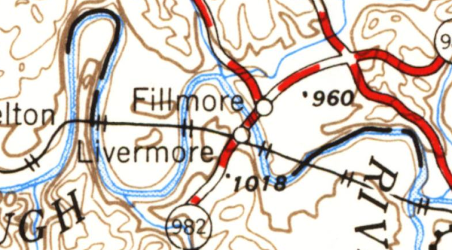
1954/54 Pittsburgh Quad @ 250,000

The current route.
1964/66 Blairsville Quad @ 24,000