These notes are dynamic in that I add maps as I find them. I try to add them in chronological order.
1718
Note the marking of the portages west and south of Fort Wayne, IN.
 |
| Paul Petraitis posted 1718 |
This map is even more confused about the rivers between the Great Lakes and the Mississippii River.
 |
| Newberry Library posted When Europeans arrived in North America, they entered an established Native world. This 1718 map, based on the writings of French missionaries and explorers from the late seventeenth century, promoted the development of a French colony in the Mississippi River Valley. Chicago (Les Checagou) is noted as an established, inhabited place, and the surrounding names locate several Indigenous nations: “Nation de Feu” (Mascouten), “Grande Nation des Illinois” (Illinois Confederation, including the Peoria and Kaskaskia), and “Les Miamis” (Myaamia). The Chicago Tribune featured this map as part of Sunday's Fall Arts Preview highlighting our Indigenous Chicago exhibition that opens this week. The map was made by French cartographer Nicolas de Fer (1646-1720) and described as "The course of the Mississippi, or St. Louis, famous river of North America in the vicinity of which one finds the country called Louisiana." Publisher Chez J.F. Bernard, Paris 1718. Paul Petraitis shared |
1746
 |
| Joe Wheeler posted “A Composite Map of the British Empire in America” 1746. From the David Rumsey Map Collection. |
1812
 |
| Tom Marcotte posted A map of Chicago in 1812, from History of Chicago by A.T. Andreas. The "Chicago in 1812" map by Alfred Theodore Andreas was printed as a retrospective, as part of his 1875-1885 History of Chicago. In this map, you can see the channel cut through the sandbar by the soldiers of Fort Dearborn. It was not very effective and continually filled in with sand. Ships bringing supplies could not access the river to unload supplies at the fort. They had to anchor in the lake and unload on smaller vessels to reach Fort Dearborn and later the town that grew around the fort. In 1833, Congress appropriated funds to improve the harbor and construct piers to fortify the channel. The investment opened the river for larger ships. Construction on the Illinois and Michigan (I&M) Canal began in 1836, and it was completed in 1848. The project took 12 years to finish, with a break in construction due to a lack of funds. When finished, Chicago grew exponentially as a city. |
1830
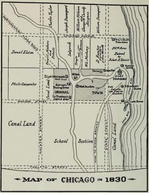 |
| Melanie Palen Shebel posted Map of Chicago in 1830 Melanie Palen Shebel shared Bill Meyer: The dotted lines indicate what was present by 1884, for reference purposes, when the map of 1830 Chicago was made. |
 |
| Terry Gregory commented on Melanie's share This is a simplification of the map sourced and drawn by A. T. Andreas in his 1884 History of Chicago, Volume 1, pages 112-113 |
 |
| Urban Archive posted Explore five centuries of Indigenous histories on the land now known as Chicago. [The image is a hotlink for Indigenous Chicago.] |
1833

 |
| Terry Gregory posted On February 11, 1835, the Town of Chicago was Incorporated when the corporate limits were extended, so as to include all land lying east of State Street to the lake shore, from Chicago Avenue and Twelfth Street. Previously the boundaries did not include the military reservation. This 1834 survey drawn by J. S. Wright reflects the expansion. Side note: Feb 11 is my birthday. |
 |
| Bruce E. Jones commented on Terry's post Very cool, lines up well with the 1833 map. I like the detail on the 1834 survey. |
 |
| Terry commented on Bruce's comment This map was designed by Walter Conley and drawn by O. E. Selzer for the 1933 Century of Progress Exposition. It was created after a two year search of libraries and archives and Miss Caroline McIlvane aided in the compilation when she provided details from the last surviving pioneers in 1900. The sketches were added to provide authenticity to the research. The map was published in the Chicago Tribune, August 13, 1933. |
1836
 |
| Original Chicago posted Map of Chicago Created by the Illinois and Michigan Canal commissioners and recorded on July 2, 1836 Glen Miller shared This map mandates that a portion of the lakeshore be dedicated as "Public Ground. A Common to remain forever Open, Clear, & free of any buildings, or other Obstructions Whatever." Named Lake Front Park, this area was bounded by Randolph Street to the north, Madison Street to the south, Michigan Avenue to the west, and the lake to the east. |
1857
 |
| Michele Ann posted Vanished Chicagoland circa 1857... |
1871
 |
| Jack Martillo posted |
1888:
 |
| Daniel Bovino posted Here’s a late 1880’s view of Roseland, Pullman, and the Calumet region. It shows a Lake Calumet in its original state and other lakes that have since been filled in. Hyde Lake is almost completely gone. Wolf Lake and Lake George have also been altered by the industrial push into this region over the last 150 years. Thankfully, some of our remaining area wetlands are under restoration. I received this wonderful map from Mendel Alumni, John Ormsby. John Ormsby: Map taken from Library of Congress. Map Room in Jefferson Building Paul Jevert shared 1880's topographical map of the southside at that time unincorporated into the City! |
Jeff Nichols posted four pictures with the comment "1892 bird's eye map of Chicago. LOC."
 |
| 1 |
 |
| 2 |
 |
| 3 |
 |
| 4 |


Evolution
 |
| Paulette Zemaitis English posted Found while researching my grandparents' residence in 1925. Susan Kroll: These annexation dates are approximates, not exact. For more information, look at the Encyclopedia of Chicago. It has an online version. Paul Walenga: Southwest side garfield ridge Clearing was 1915, 1918, and 1923. The huge 1890 was actually 1889. James Chang The source link cleaned up: page 7 of https://www.chicago.gov/.../Your_House_Has_A_History.pdf |
No comments:
Post a Comment