 |
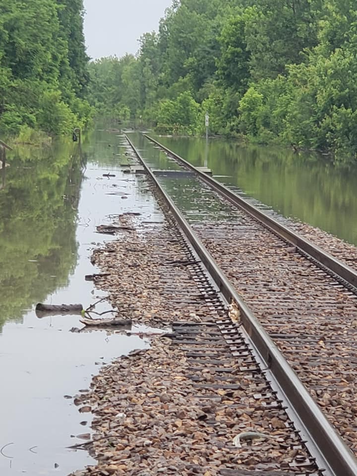
| Paw Sandberg posted That's the river sub through Boonville mo right now Paw Sandberg Norman Jennings UP rule states that if you can't see the rail through the water you can't pass over it (except in a emergency (and with a qualified employee watching the move)) Obiviously this water is not only deep enough that you can't see the rail but also extremely muddy so you can't see the tie/track conditions ballast could easily have been washed out for example. Jathan Willson Up tracks? [Former MoPac] Jathan Willson Ya we can't run trains south or north of mcalester,ok it sucks [Judging by the overpass and grain elevator, the photographer was on this Misourri River trail bridge looking East.] |
 |
| BMZ07 |
Also note that the UP/MoPac tracks flood at 30'. So they are going to be under more than 3' of water for several days.
Issue Date: 1010 AM CDT Sun Jun 2 2019The flood after the Bomb Cyclone was just a warm up. That was "only" 26.4'. "The highest recorded crest at Boonville was 37.1 feet during the great flood of July 1993. The last time the river rose above 30 feet was in June 2013." [BoonvilleDailyNews]
Expiration: 1508 GMT 03 2019
The Flood Warning continues for The Missouri River at Boonville. * until further notice. * At 9:30 AM Sunday the stage was 31.9 feet. * Flood stage is 21.0 feet. * Minor flooding is occurring and Minor flooding is forecast. * Forecast...The river will continue rising to near 32.3 feet by early Tuesday afternoon then begin falling. * At 33.0 feet...Flooding near 10th and Morgan Streets in Boonville. * At 31.7 feet...Flooding near Rural and Hart Streets in Boonville. * At 30.0 feet...The Missouri-Pacific railroad tracks on the south side of the river flood. * At 25.0 feet...Numerous farm levees are overtopped. Flooding of agricultural land and secondary roads occurs. * At 21.0 feet...Low-lying rural areas along the river flood. && Latest Location FS Stage Day/Time Forecast Missouri River Boonville 21 31.9 Sun 09 AM 32.3 early Tuesday afternoon && LAT...LON 3908 9297 3902 9255 3894 9259 3896 9286 3903 9298
[FindLocalWeather]
Paw Sandberg posted two photos with the comment: "Another view of the river sub this is close to Rocheport Missouri."
Rocheport is a town downstream from Boonville. On a map, UP looks like it is a ways from Rocheport. But if you look at a satellite image, you can see the UP tracks are just on the other side of the Big Muddy National Fish and Wildlife Refuge flood plain.
 |
| 1 |
 |
| 2 |
 |
| Screenshot @ -0:12 Doing a little “Corn Stalk” digging today in Missouri!! Joshua Schaeffer David Dockman I was always told once any bucket, clamshell, or grapple device contacts water in order to remove debris that debris needs to be discarded and hauled away as hazmat due to the contamination of oils and grease from the machine. At least on NS that’s what the Standard Practice is.Matt Weyand  Joshua Schaeffer that is usually the case. This is a highly flooded area and the river water is already severely contaminated by everything that is already flowing in it. Joshua Schaeffer that is usually the case. This is a highly flooded area and the river water is already severely contaminated by everything that is already flowing in it. |
Many farms won't be able to plant corn this year. Some have lost equipment and/or grain.
 |
South Dakota Civil Air Patrol Photo via accuweatherFlood damage and economic loss in the heartland to reach $12.5 billion this spring
[And this article was in in early April. I think this Spring has probably been worse than they expected back then.]
|
I had a graph on what percentage of corn and beans have been planted in each state, but now I can't find it. What amazed me was that Illinois and Indiana were hurting worse the Nebraska and Iowa. The problem with the Midwest states is generally not river flooding, it is the frequency of the rain. It seems like it has rained day after day after day.... When I look out my window at the grass wondering when it is going to get dry enough to cut, I remind myself that farmers are looking out their window wondering when it is going to get dry enough to get this year's income into the ground.
 |
| IL Corn posted Illinois corn farmers saw a 10% jump in planting progress this week! Hallelujah! |
 |
| Eric Shanklin posted, cropped I wanted to share what it's like trying to plant this season after all this rain. I have seen several tractors and planters get stuck and most of them look to be dry on top then suddenly it's a sink hole underneath. Eric Shanklin I was talking to my neighbor after pulling out her tractor and planter. She said she didn't care because insurance paid more as long as the seed is in the ground so its getting mudded in if she has to. [Many years ago I read that the cutoff date for insurance for corn was June 6. The problem with a big tractor getting mired is that it takes a lot of additional tractor power to pull it out.] |
 |
| AccuWeather |
 |
| Chip Walker posted NS (ex-WAB) and BNSF (ex-CB&Q) trackage at Hannibal, MO on 5/22/2019. Operations on both lines had been suspended due to high water, although NS had run a few trains to/from Kansas City through here the previous day. [I added some comments to this post.] [Some of Jennifer's photos below show that this isn't the only place in MO that NS has tracks under water. This photographer is on the levee, so like Davenport, IA, the tracks are not protected.] |
 |
| water.weather.gov 34: This is the top of the Hannibal Floodwall. 22: BNSF tracks just south of Hannibal are flooded. 21.5: At this height, water will reach the base of the remaining three flood gates on Broadway Avenue and Main Street, so these gates should already be installed and locked down. 20:5: The Burlington Northern/Sante Fe railroad tracks running North and South and the railroad yards begin to flood. At this height, water reaches the base of the two flood gates at Hill Street and Center Steet, so these gates should already be installed and locked down. Also at this level, preparations are made to install the remaining 3 flood gates on Broadway Avenue and Main Street if the forecast reaches 21.5 feet. |
 |
| water.weather.gov BNSF railroad tracks along Highway 79 south of Hannibal on June 25, 2010 at a stage of 22.3 feet. [In 2019 the river was eight feet higher than this 2010 photo.] |
 |
| Screenshot @ -0:27 Burlington, Iowa. (24.45’)Joanne Ott I couldn’t believe they took an Amtrak across the bridge today with the river so close! Chris Mills Trains are not running at all in Keokuk. Much of the tracks are not under water. But then again, where they gonna go? Edna Smith Dolbeare I was thinking the same thing! We certainly don't have traffic either direction (N/S or E/W) here in Louisiana, MO. Water is over both tracks and they filled in a levee across the KCS line across the Mississippi here. Kent Helbel Sealed traction motors are a great thing. Otherwise it's going to cost 10,000 apiece to fix. X6 [When the snowplow is throwing a wake, it is probably time to worry. Facebook didn't save a link. So I lost the comment that showed the rule in the rule book. But I remember it allowed up to 3" above the rail top with a speed limit of 5mph.] |
 |
water.weather.gov 21: Water affects the floor of the lift station at Market Street. Water also reaches the top of the railroad tracks for the BNSF railroad 15: Agricultural flooding occurs. |
 |
| 1 |
 |
| 2 |
 |
| 3 |
 |
| 4 |
 |
| 5 |
 |
| 6 |
 |
| 7 |
 |
| 8 |
 |
| 9 |
 |
| 10 |
 |
| 11 |
 |
| 12 |
 |
| 13 |
 |
| 14 |
 |
| Paul Votaw commented on Ryan's post The sand walls around the downtown just broke yesterday making the flood much worse. |
 |
| John Busbee posted I shot this today [June 2] out of the back window of #6 at Burlington, IA. The station there is obviously closed until further notice. John Busbee This is our second day running through this. The BNSF over whose tracks we operate has determined it is safe at a very slow speed. They have been running heavy freight trains over it also. Now that could change if conditions worsen. Rob Weiman Like this track was inspected? https://youtu.be/aXZDJlBZ9dM [The spokesman declares there were no haphazard materials involved soon after the video shows a spill of a red liquid of unknown substance. Also, I would think UP could find a spokesperson that doesn't keep throwing "you know" into his statements. Note that at 0:25 you can see a strong, turbulent flow next to the embankment. At least the Amtrak train was going over still water.] Rob Weiman Freight trains derail on inspected track all the time. Here is a recent derailment that was on BNSF tracks where the company determined that it was safe to operate at low speeds with a heavy freight train. https://www.desmoinesregister.com/.../iowa.../728423002/ (paycount) [Notes on that derailment] John Mier Giving me flashbacks to about 25 years ago when area was flooded. High water mark was about 5-6 high on station walls. John Busbee We aren’t stopping there for the forceable future. Passengers must go to Mt Pleasant, IA. John Busbee Just went through Burlington this evening on #5. The water has receded a great deal from where it was Sunday when I shot that video. |
Jennifer Singleton Waugh added 79 photos with the comment:
Flood 2019- May 30
I flew with my dad for 3 1/2 hours this morning from Brookfield over Mendon, Whitham, Triplett, Brunswick, and out to Glasgow. I tried to caption everything, but please let me know if I made any errors of descriptions...it all starts to run together after awhile. Please feel free to share my posts/pictures.
I'm glad someone is documenting this flood because not only is mainstream media ignoring it, the Weather Channel can't be bothered by weather events in flyover country unless it is tornadoes. The breadth and duration of this flooding makes North and South Carolina getting hit by a hurricane look rather insignificant, but guess which event got 24-hour coverage for days. Maybe the Weather Channel people don't like staying in Plain States hotels.
Jennifer's photos concerning the BNSF/SantaFe bridges across the Grand River flood plain are in the bridge notes.
 |
| I became aware of Jennifer's album because someone posted this photo in a railroad group. Working on the RR near ASB. You can see where it has washed out beneath the tracks Steve Holman NS tracks [Note how the railroad is having to use off-road trucks to haul rocks to make an access road to get to the washout. The truck that appears to be driving on water is probably on US-24.] |
 |
| Jennifer's album RR Tracks west of Hwy 11 and north of Mendon [BNSF+Amtrak+UP/SantaFe That is BNSF's transcon route where they run their high-priority, high-speed container trains between Southern California ports and Chicago. Also Amtrak's Southwest Chief normally uses this route. BNSF not only has to worry about the water on the track, they have to worry about the embankment being soaked for days and becoming soft. Furthermore, it is one thing to derail a coal or grain train because of a softened embankment, but to derail high-value containers or people is a bigger liability. However, you can tell this isn't the first flood in this area because that embankment is wider than normal. It would take longer for water to soak through it.] |
 |
| Jennifer's album RR tracks near Mendon [Are we looking at a road crossing on the BNSF/SantaFe?] |
Norfolk Southern/Wabash is flooded around Brunswick, MO. (Update: NS lost this route again in early October because a logjam destroyed the bridge that is just west of town.)
 |
| Jennifer's album ASB (old BRT) west of Brunswick [ASB is Agri Services of Brunswick. The black line near the foreground would be NS/Wabash. It appears that US-24 is completely submerged!] |
 |
| Jennifer's album ASB (old BRT) west of Brunswick |
 |
|
ASB (old BRT) west of Brunswick
[You can see the power poles that run along side US-24. This photo confirms the US highway is completely submerged. A Street View confirms the road is between the poleline and the railroad. Also note that the railroad itself is submerged near the bottom of the photo!]
|
 |
| Jennifer's album [This is where the rock haul photo was in her sequence of photos.] |
 |
| Jennifer's album bridge over Missouri River at Glasgow [KCS/(Alton+CB&Q)] |
 |
| Jennifer's album Looking down Broadway from east side of Brunswick. [They have circled back northwest. It looks like NS has staged a bunch of loaded ballast cars in their small yard in Brunswick. And that they have tied down a w/b freight.] |
 |
| Jennifer's album Ray-Carroll CO-OP [NS has staged some cranes on the loop track of the grain elevator. The two on the left have clamshell buckets, so they are ready to help load rock for track repairs.] |
 |
| Jennifer's album [It looks like they built up the land enough to keep the bins out of the water.] |
 |
| Jennifer's album [NS] RR bridge and auto bridge over the Grand River west of Brunswick [Or maybe the purpose of those cranes staged on the loop track is to clear upstream debris from the bridges.] |
 |
| Matt Weyand posted Hi-Railing panels tonight in Missouri!! Greg Cobra Jewett Where at? Matt Weyand Brunswick, Missouri [Notice the special head attachment that has a couple of arms that span the width of the rails to help grip the panel.] |
 |
| Matt Wayand posted this video Packing panels in Missouri repairing washed out tracks from the floods. Norfolk Southern Manny Villalobos How long are the panels. Matt Weyand Manny Villalobos 40 feet long. |
Update Jun 4:
 |
| Screenshot @ -2:03 I guess they will! [Just a couple of more sentences would have made this post so much more informative. I spent quite a bit of time determining that this video was shot at Carrollton, MO from the US-24 overpass looking Westish. A comment in the group I shared this video from indicated this was the first train through here in a while. Is this flood water from Moss Creek or Wakenda Creek?] A year later I saw a share of this post [There are some comments about NS still running roadrailers to keep Ford happy.] |
 |
| Street View |
 |
| Jennifer's album Running over Whitham levee [This levee was built better than the Garden of Eden Levee. First of all, it is of such uniform height that no one part gets an excessive amount of water. Secondly of all, it is strong enough that it can be overtopped without breeching. Several of the remaining photos in her album shows breeches in the Garden of Eden.] |
 |
| KOTV Screenshot @ 1:13 [All of Webbers Falls. OK, is flooded and could be for several weeks.] |
 |
| Scott Kelsey posted |
It has been over two months since the Cat 2 equivalent Bomb Cyclone hit the Plains States on Mar 13 while there was still thick ice on the rivers. I can remember back in the 1980s when one of the predictions of a warmer climate is more severe and frequent weather events. It is too bad that Mother Nature is not precise enough to flood just the homes of man-made climate change deniers.
Karla Miller posted shared four photos:
 |
| 1 |
 |
| 2 |
 |
| 3 |
 |
| 4 |
 |
| BNSF Starting this spring and then into summer, the biggest issue for BNSF and its agricultural customers was major flooding across portions of Nebraska, Iowa, and Missouri. For weeks and then months, sections of track that run parallel to rivers in these areas were out of service due to high water from snowmelt and rain. Once the water receded, BNSF was able to aggressively restore these key sections and return service to the levels customers expect. “It was an historic event, and we tried to give our agricultural customers the best service we could considering the challenges we faced both during the flooding and recovery. We provided advisories and updates to keep them informed of our progress,” said Guthrie. |
No comments:
Post a Comment