Wednesday, May 3, 2017

BNSF/Frisco Bridge over Gasconade River at Jerome, MO is Flooded

(Bridge Hunter, Satellite)
BNSF railroad posted
Massive flooding has washed away a stretch of the BNSF rail line that links Springfield and St. Louis. Take a look at what the swollen Gasconade River has done to the tracks at Jerome! The river 'usually' flows beneath the iron truss bridge in the background. Photo courtesy Doolittle Rural Fire Protection District.
Looking at the fresh ballast and stone on the east side of the bridge, it appears this part has been washed out before. And you can see a glimpse of water through the truss, so it appears the steel girders part of the bridge is submerged.

Looking at the Bridge Hunter link, Steve Conro caught the river at a higher level than David Backlin did, but it was still a long way from going over the top of the bridge.

TravelBlog
Jerome is along US-66 so Jerry and Rita also caught a picture when the river level was rather low. A Bridge Hunter comment provided a couple of postcard images. It used to be an all-truss bridge that was replaced in 1961 with steel girders except for one Warren Truss span. It also appears a  concrete lining was added to the footings of the cut-stone piers and they added new piers so that the steel girder spans would be shorter.

Amanda Black's postcard colection from a Bridge Hunter comment

Amanda Black's postcard colection from a Bridge Hunter comment

I normally don't bother with a rather small bridge so far away, but this picture puts the following BNSF outages in perspective. This was dated 04/30/2017. It appears the yellow at-risk line needs to be updated to red OOS and that Springfield might now be isolated from rail service. Tom may have used a login to get this map because I was not able to find a more up-to-date version.
BNSFposted by Tom Meyer

An Existing Chicago Bypass for Coal

(Update: BNSF also bypasses Chicago by transloading taconite to Lakers at Lake Superior.)

I've discussed railroad traffic bypassing Chicago before. And GLBR is still trying (Update: the STB said no.). But I have discovered there is already a bypass for Wyoming low-sulfur coal going to power plants near Detroit --- use railroads to Duluth, MN and then use boats like the Paul R. Tregurtha to plants along the St. Clair River.
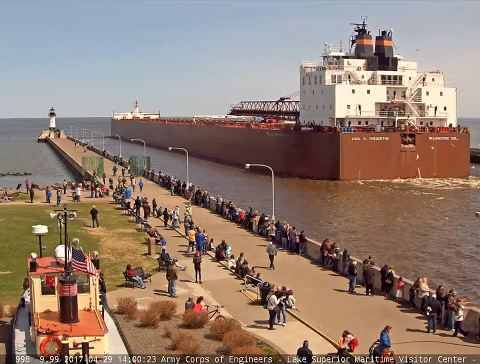
Jim Banke posted
The Paul R. Tregurtha departs Duluth for St. Clair, loaded with coal. The questions of the day, however, are does this screen grab from dulutharbor.com include Jane Herrick, or was she on the opposite pier, and did she get some great video? (OK, the last question was rhetorical. Of course she got great video if she was there!)
Satellite
I added a comment asking if this satellite image is the destination and if it was carrying coal that came from the Wyoming. Other comments confirmed it was low-sulfur western coal that is going to this destination. Then I noticed that several power plants are at this unloading facility: Detroit Edison, St. Clair Power Plant, and DTE Belle River.

Note the destination has just a hopper and some conveyor belts. To unload, the boom on the boat that is in front of the pilot house is swung to the side so that the end of the boom's conveyor belt dumps into the hopper. Bulk transport boats on the Great Lakes changed to self unloading equipment a few decades ago.


Jane Herrick's video of the boat departing Duluth. Evidently it is tradition for a boat to blow a sequence on their horn and then for the control house of the lift bridge to reply. As the boat moves pass Jane, you can get a good view of the unloader and hear the bridge salutes. Then you can hear the bell on the bridge warning that the span is being lowered. Unfortunately, Jane is not a bridge fan as well as a boat fan, and she doesn't catch any footage of the bridge span going down.

Sue Bob Kruse posted
Paul R Tregurtha heading out into Lake Superior after departing the Twin Ports (Duluth/Superior.)
There is a website that allows tracking the boats by name.

It doesn't always go just to the power plants because currently (7:40 5/3/2017) it is in Lake Erie. If this laker is back hauling another material from a port on Lake Erie, I wonder what that material would be. Or maybe it had to go to a Lake Erie port to refuel for the return trip.
MarineTraffic
When I put the mouse over the SMET destination, I got a popup of "Destination Port not Recognized." The popup for SCL is "ST CLAIR [US]."

Update: The top photo of it leaving Duluth was April 29, 2017. This photo of it returning for more coal was May 4.

Paul Scinocca posted
Paul R Tregurtha arriving Duluth this Wednesday late afternoon, after fueling at Calumet off to MERC to load coal.
Jane Herrick's video of the 5/4/17 arrival with two salutes. You can hear the announcement from the visitor center explaining that it was built in 1981 and it is the longest boat operating on the Great Lakes, 1013'. The unloading boom is 250'. Unfortunately, the propwash of the boat drowned out her description of the engines.

Coal handling facilities are usually pretty east to spot because they have a big, black pile. So is this the MERC? It looks like a converted ore dock. (Update: it is an ore dock.)

3D Satellite
Or maybe MERC is here. (Update: this is a coal loading doc.)

Satellite
Another boat that keeps coal trains out of the Chicago area. 68,000 tons would be about 6 or 7 trains.
North Shore Boat Watcher posted
Have the family visiting this weekend, and I was finally able to go back down to canal to catch my first boat this week!
The American Integrity (1004') owned by the American Steamship Company departed the Twin Ports through the Duluth shipping canal after loading over 68,000 tons of western coal at the Midwest Energy dock in Superior, WI. The next stop for the Integrity will be the coal dock in Presque Isle, MI.
That was boat #1 of a two-fer this evening with the Algoma Enterprise arriving shortly after the Integrity's departure.

M/V James R. Barker also carries coal from Duluth, MN to St. Clair, MI. Each load keeps several more coal drags out of the Chicago area.

Update:
Todd Shorkey posted
Indiana Harbor unloading at Consumers Energy in Essexville. June 20, 2017


Tuesday, May 2, 2017

Political favors for a company as old as 1642

The first colonial iron-works of any importance was established at Lynn, Massachusetts, in 1642. Eleven "English gentlemen," mostly military officers, supplied the capital, which was only five thousand dollars; and a son of Governor Winthrop furnished the political "pull." The latter was the company's chief asset. Every special privilege young Winthrop could suggest seems to have been promptly granted, the most important being:
- A monopoly of iron-making in Lynn for twenty-one years.
- Exemption from taxation for twenty years and from all military service.
- A free gift of three square miles of land for every furnace built, and of all necessary ponds and waterways.
- Permission to sell to Indians and to enemies of the British government. [RodneyOhebsion, search for "first colo"] 

Unlike today's tax payers, the citizens of Lynn preferred fairness for all over jobs for a few.

The granting of so many special privileges angered the Lynn Puritans, and they began a series of persecutions that finally harried the iron men out of business. They declared that the company was in league with the pirates, and raged because it destroyed the forests. Several farmers brought suit on the ground that its dam had flooded their fields; and a mob went by night and cut away the flood-gates. The wife of John Gifford, the unpopular agent of the company, was next charged with being a witch, and narrowly escaped the penalty. [RodneyOhebsion

CB&Q's Lunar Lights and Amtrak Trains on the Racetrack

Mark Hinsdale posted two pictures with the comment:
"Then and Now" in the Namesake Town...
For many, many decades now, the former Chicago, Burlington & Quincy main line, today known informally as the BNSF "Racetrack," has hosted a mid afternoon westbound passenger train out of Chicago, destined to California, by way of Denver. Here are two views of Amtrak's version of it, taken from very nearly the same spot in Hinsdale IL, 42 years apart. Both photos by Mark Hinsdale
Amtrak Train #5, "California Zephyr," 5-75
Amtrak Train #5, "California Zephyr," 4-17-17
1, Then

2, Now

A question was asked about the extra offset targets in the "then" photo. Since no one answered, I asked in the Racetrack group. I added a replied to the question:
Dennis DeBruler I posted this question to the Racetrack group and got the answer: "Jacob Metzger They were GRS or WRRS crossing lamps with a blue lens designed to show a restricting indication on a stop signal, I believe. They were taken out in favor of different signal rules by BN in the early 70's." In other words, they indicated if the Stop indication was absolute or restrictive. 

Monday, May 1, 2017

Amtrak: 1971 and 2016 maps


1971 from Amtrak history
Jim Arvites posted

1910 Michigan Central Railroad's Detroit River Tunnel

(Satellite: West PortalEast Portal)

Peter Dudley shared his photo
An original monochromatic Detroit Publishing Company (DPC) photograph shows the Detroit portal of Michigan Central Railroad’s Detroit River Tunnel, c. May 1910. The project was rapidly nearing completion – the official completion date was July 1.
The comment on his photo:
An original monochromatic Detroit Publishing Company (DPC) photograph shows the Detroit portal of Michigan Central Railroad’s Detroit River Tunnel, c. May 1910. The project was rapidly nearing completion – the official completion date was July 1.
The Detroit portal was in the shadow of the Vermont Street truss bridge, which was built years earlier. The tunnel approach, M.C.R.R.’s lengthy Third Street Yard (right), and the double-track branch line to the riverfront (left), were carefully inserted under the bridge, without disturbing it.
The branch line provided access to M.C.R.R.’s red-brick 1884 depot on Third Street, as well as three railroad car ferry slips, which were abandoned and filled-in, after the tunnel opened. After the new (now century-old) Michigan Central Station (MCS) opened on 15th Street on December 26,1913, the burned-out, blackened remains of M.C.R.R.'s previous depot on Third Street were transformed into New York Central Railroad’s Third Street Freight Terminal. The soon-to-be-renamed Detroit People Mover / Joe Louis Arena station currently occupies the site where the old depot's clock tower once stood.
The diagonal route to the riverfront was actually laid through the streambed of May’s Creek c. 1847, when recently-privatized M.C.R.R. moved its terminus to the riverfront from Campus Martius. The former creek bed became a naturally-occurring, depressed railroad right-of-way.
All of the relatively-surface-level trackage southeast of the tunnel portal has been abandoned, but the route still has some potential – as part of a rapid transit line, connecting downtown Detroit with Metro Airport, and / or another pedestrian / cyclist limited-access rail-trail, like The Dequindre Cut Greenway on Detroit's east side. Canadian Pacific Railway freight trains still make their way across the river, far below.
The bottom edge of the photograph shows the top of a reinforced-concrete signal bridge, built over the double-track tunnel approach. Four bolts embedded in the concrete (left) awaited the installation of a semaphore signal over the north / upstream / westbound track. Later, single-lens searchlight signals replaced the semaphores – later still, the sagging signal bridge was removed.
An out-of-focus part of the truss bridge carrying Porter Street over the tracks (lower-left corner) is also visible.
DPC shopped and hand-tinted this photograph – it became the basis for several photo-postcards. A version of this image is the centerpiece of a “Souvenir of Detroit” plate, currently on display in the window of the A.C. Dietsch Souvenir Shop, located in Detroit Historical Museum’s Streets of Old Detroit exhibit (photo retrieved from www.Shorpy.com, also available as DPC Collection photo det 4a23701, accessible from www.LOC.gov).
This route also used to serve the Michigan Central Station.

Update:
HS House Camping posted
Detroit circa 1910. "Approach to the Michigan Central Railroad tunnel." Another view of the electrified tracks going under the Detroit River. 8x10 inch glass negative.
Richard Fiedler shared

Detroit Historical Society posted
On July 1, 1910, the Michigan Central Railway Tunnel was completed under the Detroit River. The Windsor approach is pictured on this 1920s-era postcard from our collection. Noted on the reverse, the tunnel was constructed in sections, "all work being done from the surface of the water without the use of compressed air. The length from portal to portal is 1 3/8 miles, and from summit of grade 2 ½ miles. It was built by the Detroit River Tunnel Company for the M. C. R. R. at a cost of $8,500,000."

Barry Sell posted two photos with the comment: "Detroit circa 1910. "Michigan Central Railroad tunnel."
1

2

Jeff Wilson shared his post
Admin
+1
I ran trains thru this tunnel for 8 years.
1.8 % grade on one side, 2% on the other.
8100 foot tunnel.
5200 ft 5,000 tons was a stall train for one AC or GEVO
5200 ft 10,000 tons was a stall train for 4 SDs or 2 ACs or 2 GEVOs
The biggest issue was rear end clearing 15 or 20 mph CR Shared Assets and trying to get it up to tunnel MAS of 40 mph.
Once I had 2 ACs and stalled, an SD40-2 came out of Windsor and coupled up and train still wouldn't budge and actually sucked us back into the tunnel when i released the brakes.
I can faintly see the third rail that was used in the tunnels at the time.

Jeff commented on his post, cropped
[This is on the backside of the postcard.]

Benjamin Gravel shared Detroit Historical Society's post
On July 1, 1910, the Michigan Central Railway Tunnel was completed under the Detroit River. This postcard notes that it was constructed at a cost of $8,500,000 and is 1 3/8 miles in length.
Peter Dudley added eight photos as comments
Stephen Phillips the tunnel was powered by electric locomotives from its being built ...... Diesel electrics replaced them when steam was retired ...

Jeff Arthur Knorek posted
The caption reads: "1910. Electric engine, Detroit River Tunnel". This is likely an 8x10 silver gelatin contact print from a glass plate silver gelatin negative. The Detroit River Tunnel Company was controlled by New York Central. Image from ShorpyDOTcom.
Here is some more info on the Detroit River Tunnel Company:
http://www.trainweb.org/oldtimetrains/photos/us/DRT.htm

(new window) I recommend you skip to about 2:50. You can see the notches they put in the left tunnel to clear autoracks. I wonder if it can also handle double-stacks.


Another video of a train coming out of the tunnel. (source)


Detroit Daley has an article on the tunnel. The link for this article was shared by Peter Dudley.
Ross Gray commented on Peter's share
Tunnel section being floated down the St. Clair River

Winninoah Poohi posted
Supervisors watch as the last tubular section of the Michigan Central Railroad tunnel is sunk into the Detroit River, connecting Detroit and Windsor. The railroad tunnel opened on July 26, 1910 and is still in use today.
Library Of Congress

safe_image for Shorpy
The Detroit River circa 1910. "Michigan Central R.R. tunnel -- sinking the last tubular section. W.S. Kinnear, Chief Engineer, Butler Bros. Construction Co., contractors." 6½ x 8½ inch dry plate glass negative, Detroit Publishing Company. 
Ted Gregory: Ran hundreds of trains thru that leaky tunnel

Peter Dudley posted
A "Pesha" photograph (no. 783) shows the Detroit portal and descending approach to the Michigan Central Railroad Detroit River Tunnel as it neared completion, c. 1910. The Detroit tunnel entrance was inserted directly under the long-gone Vermont Street Overpass, without disturbing the truss span.
Mr. Pesha's numbered images provide an excellent chronology of tunnel construction, from c. 1906 through July 1, 1910 (when the tunnel was completed).


safe_image for CP Rail purchases full control of Detroit River Rail Tunnel
Dan Gurley shared
Ted Gregory: The issue with this tunnel is CP cannot run double stacked 9'6" containers. They tried it once and it didn't work out very well. There have been plans in the works for decades to build a new rail tunnel under the Detroit River with the necessary clearance, similar to what CN constructed between Port Huron and Sarnia.
Comments

Viral Media posted
Michigan Central Tunnel
The Michigan Central Railway Tunnel runs under the Detroit River connecting Detroit and Windsor, Ontario. The railway tunnel opened for service in 1910.  In 1968, the tunnel passed from the New York Central Railroad to Penn Central, and in 1976 to Conrail. In 1985, Conrail sold the tunnel to the Canadian National Railway and Canadian Pacific Railway, with each getting a half share. The north tube underwent a $27 million enlargement in 1993 to allow passage taller rail cars. Canadian Pacific took full ownership of the tunnel in 2020.
In the foreground is the historic Michigan Central intercity passenger rail station in Detroit, Michigan built in 1914. The Beaux-Arts style architecture was designed by the Warren & Wetmore and Reed and Stem firms who also designed New York City's Grand Central Terminal. The station was active until the cessation of Amtrak service on January 6, 1988.
By 1988, Michigan Central had already become run-down. Detroit was declining in the 1980s, and after the station closed, it became prone to vandalism. The grandiose building that was a symbol of pride became the symbol of Detroit’s decay.
In 2018 Ford Motor Company purchased the building for redevelopment. Michigan Central Station will be part of Ford's Corktown Campus. The former train depot be home to the automaker's electric vehicle team. The campus will include a 30-acre walkable community surrounding the train station. Between 2018 and 2021, the building's exterior was repaired and the electrical and mechanical systems were replaced; in August 2021, the renovation entered the third and final phase, focusing on the interior

UP/MoPac Barrett's Tunnel and Museum of Transportation

William A. Shaffer posted
Barrett's Tunnel
Barrett's Tunnel was the first railroad tunnel constructed west of the Mississippi River. This photo was taken at the National Museum of Transport in Kirkwood, MO. (Photo by William A. Shaffer)
This the St. Louis area museum that has the UP Big Boy #4006. It also has the "Union Pacific #6944 EMD/1971 D Model DD40AX 6,600 hp; 2 engines D-D." The Museum of Transportation is west of the I-270.

3D Satellite
I had to study a satellite image for a while before I finally found the tunnel. (I assume the Big Boy is in one of the buildings to help preserve it.)

The two Barretts Railroad Tunnels are notable as the first railroad tunnels west of the Mississippi River. Situated off Barrett Station Road near Kirkwood, they were part of the route laid out for the Pacific Railroad by Chief Engineer James P. Kirkwood to link St. Louis to the West. The first trains ran to Franklin County in1853, but the line did not reach Kansas City until 1865. The railroad, recently acquired by Union Pacific, has been entirely rebuilt over the years, leaving the tunnels as the only structural reminder of the original line left in Missouri. The west tunnel is now on the grounds of the national Museum of Transport, while the east one is still owned by the railroad. [StLouisCo]


When I worked at MOT (over 10 years) I had several opportunities to go into the tunnel and have walked its entire length several times. It was built in the 1850s through a limestone ridge. Much reinforcement work was done by the MP over the years and there are concrete support piers in part of it. But when the railroad relocated its tracks in 1945 the tracks in the tunnel were removed and all maintenance ended. As the museum grew at this location new track was eventually run through the tunnel and there are films of the Illinois Terminal railbus going all the wa through it. But as was mentioned there was a partial collapse of a side wall that crushed a streetcar that was among the things stored on that track when there was no other overhead cover available. Once the tunnel was cleared from that it was found that the drainage had become blocked, being partly the cause of the collapse. Remember that the tunnel is on a grade with the east end being higher than the west. For whatever reason the track was removed. Later there was a reallignment of much of the track as part of the work being done when the larger shed was being built in the early 1990s. A contractor installed new track about half way into the tunnel by just pushing ballast in ahead of the work and then putting the track on it. This process raised this track a foot or two above the historic level it was at in the east half, there being none in the west half. That is where it remains today. A few things are stored in the tunnel most of the time, and when they are removed there are small pieces of the roof limestone found all over them. The drainage has never been restored and it will be very, very expensive to make the tunnel usable for passenger carrying trains in the future. Running a caboose or two up to its gate is no problem, but it isn't safe to go inside at present and isn't being done. [Ron Goldfeder, rypn]


More St Louis area tunnel background .....
There is a ridge running along the southwest corner of the greater St Louis area - the first evidence of the upcoming Ozark "mountains" as you continue to travel southwest. This ridge blocked both the MoPac, and later, the Frisco rail lines as they headed out of St Louis.
The MoPac, as the Pacific Railroad originally, tunneled through the ridge with the two Barretts tunnels. The west Barretts tunnel is the one on the grounds of the National Museum of Transport. This makes our museum one of the few in the world to have a railroad tunnel in their collection!
During WW2, the Barretts tunnels caused unacceptable clearance restrictions, so the MoP took them out of service, relocating their line to a new series of cuts through the ridge on the southeast side of the two Barretts tunnels. Both tunnels still exist.
The Frisco had a similar problem with the ridge blocking them as they built their new line to connect St Louis with the start of the "Southwest Branch" in Pacific, MO, which ran down through Rolla to Springfield. Prior to this, the Frisco ran over the MoP line to Pacific, then took off on their own. The Frisco also solved the ridge problem by boring a tunnel at Meramec Highlands, just west of the Meramec Highlands/Osage Hills depot. This area is about a mile or so south of the MoP tunnels. 
As old tunnels usually do, clearance troubles resulted at Meramec Highlands. In the late 1920's the Frisco relocated their line slightly to the southeast, running the track through a new cut in the ridge. I have an article around here somewhere describing the relocation project. The Meramec Highlands tunnel also still exists.
Ken 
ps: Further on down the MoPac (now UP), there is a much longer tunnel just before the RR reaches Pacific, MO. That tunnel is still in service. You can see the east portal from I-44 if you look quickly. [meteor910, frisco]

More pictures are in a blog.

You can see the tunnel entrance near the top of this view. Note how vertical the walls of the replacement cut are. That must be strong rock to have vertical walls that high.
Satellite