 |
| Satellite |
On one of my trips back to Chicagoland from Kentucky, I skipped my usual I-57 route and went out of my way so that I could ride this ferry. We arrived at the apron at 3:00.
 |
| 20170322 8149 |


...it is in position to push the ferry.

3:16:29


|
| Satellite |
|
| 20170322 8149 |
 |
| Street View, Jun 2022 |
 |
| Randy Volskay posted I find draw spans intriguing, and I'm sure I'm far from the only person, with such fascination. This span is the Armour-Swift-Burlington drawbridge spanning the Missouri River, between downtown Kansas City, and North Kansas City, Missouri. Like a couple other draws, in the area, it once featured an auto roadway, on the upper deck, with rails on the lower. This span was peculiar in that the lower chords simply pulled up through the girders of the main structure, the main span did not mover. It was raised, this day, but I never found out if it was because of the flooding, or a standard exercise. River traffic had been suspended, at that time. |
 |
| Jim Pearson Photography posted Kaw River Railroad lease unit WAMX 6033 slowly moves across the Kansas River into at Santa Fe Junction with a daily mixed freight on June 29th, 2022. According to Wikipedia: The Kaw River Railroad (reporting mark KAW) is a Kansas City, Missouri railroad, established in June 2004. Twelve miles of original track served the Kansas City Southern Railroad and its customers in Kansas City and Union Station. The original KAW was a Kansas City Southern Railway Company property and was the first shortline Watco began operating for KCS, serving customers in the Greater Kansas City area and interchanges with the BNSF, KCS, and Union Pacific. The April 2005 expansion was a BNSF property serving customers in Clay County, Missouri and interchanges with the BNSF at Birmingham, Missouri. The KCTL interchanges with the BNSF, ICE, KCS, Norfolk Southern and Union Pacific at Kansas City. Tech Info: DJI Mavic Air 2S Drone, RAW, 22mm, f/2.8, 1/2000, ISO 110. https://fineartamerica.com/featured/kaw-river-railroad-lease-unit-wamx-6033-at-kansas-city-mo-jim-pearson.htmlJeff Cook: If you look closely, the white building with the big trusses on top is the arena formerly known as Kemper Arena. It was host to the 1976 Republican National Convention, the 1988 Final Four, the Big 8 and Big 12 basketball tournament, numerous NCAA tournament games, many concerts and other events. The first concert I ever attended in person was Elvis Presley there in 1977, just 2 months before his death. Many great memories in that building. The KC West Bottoms area is still thriving with railroad traffic these days. Robert Youngers: Jeff Cook and Kemper is where the stockyards used to be. There was tons of tracks here according to the map I have (it shows the RI, Santa Fe, Katy, Milwaukee Road, and BN had small yards at Kemper). Santa Fe had a line that ran along the flood wall to the RI bridge where it merged with the Frisco and a KCT line that continued on from BN Jct. At the RI bridge it became the Kansas City Connecting RR which ran apparently underneath the MP and UP lines (and also connected to them) and ended at a small yard on the north side (there is a trench visible on Google that should be where the line was: https://www.google.com/maps/@39.098222,-94.6100193,194m/data=!3m1!1e3 And BN (Burlington) had a small yard where that construction lot is. And the KCS line to Armourdale was along the north side of the river. Tim Parker: Are there any pictures of the flood bridge up? Do they open it often for maintenance? Derek Brady: Tim Parker it's rarely opened except in severe flooding conditions. It isn't a simple process like a drawbridge. They do maintain it, just not to the full extent of opening it. I've seen a few photos, but I don't know where. It hasn't been opened very often, early 50's (54 ish I think) and '93 and maybe once more. They had it ready to open when I was working out of Herington to KC , same with the bridge across the Ks river at Topeka, but they didn't raise either. By ready I mean rails cut, people on standby just hanging around waiting for the word to start the lifting process and put flood gates in. |
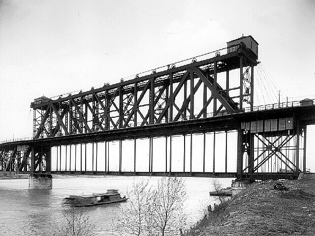 |
| kcengineers "The bridge is one of only two of its type ever built. To satisfy the railroad's need for the railroad tracks across the bridge to be as low as possible, and the riverboats' need to have enough clearance under the bridge, Waddell developed a unique design that had automobile traffic on a top deck and rail traffic on a lower deck that could be raised to allow riverboats to pass. The lifting of the lower deck was accomplished by telescoping the hangers of the lower deck into the truss members of the upper deck, thus allowing automobile traffic to continue even when the lower deck was raised." |
This is the Armour-Swift-Burlington Bridge (or just ASB Bridge) across the Missouri River at Kansas City, Missouri.This historic 1912 bridge once carried both road and rail traffic, but the roadway deck was removed following completion of the Heart of America Bridge just downstream.The main span railroad deck is suspended from the upper level, stationary truss and can be raised via a system of cables, pulleys, and counterweights up into the truss to allow river boats to pass under.This bridge is an American Society of Civil Engineers National Historic Civil Engineering Landmark.
 |
| 1 |
 |
| 2 |
 |
| 3 |
 |
| 4 |
 |
| Google Book, p772 |
 |
| Old Postcard from Bridge Hunter |
 |
| Randy Volskay posted NS transfer run crosses the Armour-Swift-Burlington draw bridge, in Kansas City, Mo. This is a pretty unique span. The truss sits above what used to be the highway deck, and the vertical plate columns would lift the track girders to the required height. The highway was moved, about 25 years ago, but the railroad portion, obviously, still moves along. |
 |
| Postcard Digitally Zoomed |
 |
| photo from MO,48-KANCI,16--9 from mo0450 |
 |
| Digitally Zoomed from the .tiff copy |
Initially, the deck could be raised in 50 seconds, but due to the age and condition of the machinery, it now [1984] takes about three minutes. The synchronization of the two sets of machinery at either end is handled by a counterweighted rope drive connecting opposite motor shafts. The motors are connected electrically and both operate simultaneously. In case either should be out of service, the lifting deck can be operated by a single motor from either end, the machinery at the opposite end being operated through the rope drive. Limit switches cut off the current to the motors and apply the brakes near each limit of movement. [HAER, p10]
 |
| modot_293A_004, July 14, 1951 Disasters, Floods, 1951: Three unidentified men examining flood damage on the washed out railroad level of the ASB Bridge over the Missouri River, Clay County |
 |
| Randy Volskay posted Coming home, today, and the old ASB draw bridge, across the Missouri River, in Kansas City, was raised (all the other spans were open, as well). This isn't a frequent event, and I've never been fortunate enough to have seen it. |
 |
| James Clary posted One from Kansas City Blair Denny When I worked for the KCS as a conductor and engineer, we delivered empty coal trains to BNSF Murray Yard in North Kansas City from the KCS's Knoche Yard in Kansas City over this structure. (More often we were routed over the Kansas City Terminal and BNSF along the Bluff Track to the Hannibal Bridge.) This photo of the ASB Bridge is looking north over the Missouri River. The large span over the river's channel lifts vertically. (Facebooked) |
 |
| Edward Schlag posted The Missouri was running fast and high that day. ASB RR Bridge in action back in August, 2011. Edward Schlag I was there one day when it went up. The noise the bridge and cables made is indescribable! Very cool. |
 |
| Marty Bernard posted What Bridge Is This? This is a Duane Hall photo. The hard to read processor's date on the slide seems to be August 1984. Does the color of the bridge look right? Just beyond the bridge, another bridge is under construction (?). [EDIT] The Armour-Swift-Burlington Bridge, also known as the North Kansas City Bridge and the LRC Bridge, is a rail crossing over the Missouri River in Kansas City, Missouri, that formerly handled automobile traffic. Wikipedia Also watch it move: https://www.youtube.com/watch?v=oFVVs8fMnCw Sawyer Regensberg: I thought this was ASB. Sure has heck saw the real thing often enough! Fun (and totally unrelated) fact; there’s a sunken LCVP landing craft...with a STEEL hull no less...under the south end of the bridge. You can see it when the rivers down. They were built just upriver and I suspect that one wasn’t sealed correctly and sprang a leak, being rammed ashore to try and save it Marty Bernard shared |
 |
| Street View, Jun 2015 |
 |
| 1 |
 |
| 2 |
 |
| 3 |
 |
| 4 |
 |
| 5 |
 |
| 6 |
 |
| Paul Petraitis posted Here's the only copy I've seen of Polycarpus Von Schneidau's daguerreotype of the aftermath of the March 12, 1849 "spring freshet" flood that damaged bridges and dock facilities from Peoria to Chicago...its our town's oldest photograph! Paul Petraitis posted Earliest daguerreotype of Chicago,wreckage in the Chicago River from the spring freshet March 1849, looking NE, photo by Von Schneidau...the original plate is some where in an eastern collection. Lorri Weiskopf Redmon Never heard of a "freshet" Interesting. Thanks. Patrick McBriarty Admin This was the aftermath of a spring thaw and flood where the Des Plaines River over spilled its banks and flowed into Mud Lake and into the South Branch creating a rush of water, ice and debris which piled up against the bridges (pontoon float bridges) that were successively destroyed pushing the mess and boats in the river into downtown with some being flushed out into Lake Michigan. As of course the Chicago River ran into the Lake and was not reversed until 1900. This story was told in my book “Chicago River Bridges” and in the PBS documentary “Chicago Drawbridges.” This is a woodcut from a daguerreotype that was taken on March 12, 1849. It was discovered in December, 1897 in an old vault. John Carl Frederik Polycarpus von Schneidau (1812-1859) is considered Chicago's first photographer (daguerreotypist). |
 |
| safe_image from a Neil Gate post
The 1849 Calamity on the Chicago River not only wiped-out a river full of vessels but destroyed the city's entire river infrastructure and... there was the loss of life too.
Read about the resilience of Chicago and see an actual Daguerreotype photograph of the disaster.
CLICK TO READ ─► https://drloihjournal.blogspot.com/2017/11/calamity-on-chicago-river.html in my Digital Research Library of Illinois History Journal™
|
