Sunday, March 6, 2022

BNSF/SP Cantara Loop Bridge over Sacramento River near Dunsmuir, CA and Tank Car Failure

(Bridge Hunter; Satellite)

I remember the July 14, 1991, derailment that prisoned the river, but it must have been a TV show because I can't find any notes on it. So here goes.

In this photo, note the white freight car laying in the river. That was a tank car carrying 19,000 gallons of the Pesticide metam sodium. Almost every living organism in 38 miles of the river was dead. This incident rather literally killed the fly-fishing tourist industry, which was a good part of Dunsmuir's economy. The fish population recovered in 3-4 years thanks in part to a 3-year fishing ban. [abc7news
Some sources called it a herbicide, but because it fumigated into a green gas, it must be a pesticide.
reddit, photo 3
 
The regulations for tank cars that carry petroleum products have been changing. Are the regulations for puncture resistance for tank cars carrying hazardous material not as stringent? It seems that the forces of just falling off a bridge would be rather benign, yet the tank car's integrity failed.
sacriver


A river is not supposed to have pretty colors.
wildlife

Nor is it supposed to be green.
RealNews
[The sources were running about 50/50 in terms of herbicide vs. pesticide. But this article indicates it was a pesticide because "the pesticide that spilled into the river is a fumigant. So, when combined with water, it created a toxic gas that billowed 45 miles downriver to Shasta Lake, where the chemical dispersed....Naomi Croft remembers the incident well. She heard a loud crash and 'all of a sudden, it turned green outside.' "]

Some people did suffer "persistent respiratory disorders, including irritant-induced asthma." [chest]
 "Within a week, every fish (1.1 million in total) and all other aquatic life in a 45-mile stretch of the Sacramento River was killed. In addition, many residents living along the river became ill with symptoms that included headaches, shortness of breath, and vomiting. The spill considered the worst inland ecological disaster in California history." The settlement in 1994 was for $16m. [lieffcabraser]

In 2000, UP built a "guard" rail to keep derailed cars from falling into the river. [Amie Sanderson comment on BridgeHunter] Back in 1991, Southern Pacific still owned this route.
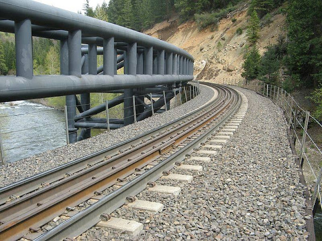
Ron Sherman posted
Now, THAT'S a guard rail
Cantara Loop, near Dunsmuir, CA
This is where, in 1991, a Southern Pacific freight train derailed, resulting in a massive chemical spill into the Sacramento River. The article below reports on how the area has rebounded and recovered.
 I believe they said the train was put together with a string of light cars in between lengths of heavy cars, and that combination led to the light section being pulled off the tracks around the curve. Does that happen?
Andrew Beeman: Ron Sherman it’s called a “string line derailment”
Jason Ludford: Ron Sherman I was on that derailment and basically what you just described did happened but there was one other factor is it the lead units powered out in the curve they had a SD unit behind 2 GP units The SD unit started jumping up and down on the rails and then rolled over.
Ron Sherman: Jason Ludford Yikes! What does 'powered out' mean?
Jason Ludford: So what I mean is They lost traction On the curve when they lost the traction the rest of the train and all the slack came up behind the three lead units at that point the number three unit being it was more powerful than the two lead units started bouncing up-and-down on the rails in the train went backwards and that’s what they mean by string lining and rolled everything into the river this all happened about 10 o’clock at night we got the phone call about 1030 started rolling equipment and trucks that way we got there about seven or 8 o’clock the next morning by the time we got there the tank car was the main focus so we went down and investigated you could drive a Volkswagen through the middle of it there was two box cars also in the river immediately pulled them out of the river got them out of the way and then we started focusing on the locomotive that was rolled over while all this was going on we had every federal government agencies and state agency are telling everybody what they wanted to do by that time the tank car was pretty well empty if its contents.

Photo by MostlyDeserts, License: Creative Commons Attribution-Share-Alike (CC BY-SA)

Photo by MostlyDeserts via BridgeHunter, License: Creative Commons Attribution-Share-Alike (CC BY-SA)

This curved bridge is no stranger to string-line derailments. This one happened in Apr 1976.
MtShastaNews
"This was the scene after three flat cars containing four vans plunged into the Sacramento River after nine cars jumped the tracks on the Cantara bridge." The article quotes a SP public relation official, George Krause, who describes a string-line derailment.
"As salvage operations were taking place over the weekend, some of the packages of detergent and containers of a toilet bowl freshener dumped into the river causing bubbles to form and the river to turn blue. These items were biodegradable, according to Krause, and should cause no harm to the water."

The cost of cleaning up derailments must come out of a different budget so that it doesn't increase the sacred operating ratio of PSR railroad management. It appears that UP is still building trains with heavy loads behind empty cars because they had another string-line derailment in Aug 2021. Does UP reimburse the payroll and travel expenses for those six agencies that sent employees to the scene?
Mount Shasta News posted
Train Derails Near Site of Major Railroad Chemical Spill 
On Friday, 27 August 2021, there was a Union Pacific train derailment at Cantara Loop 
-18 cars derailed, 11 down, 7 standing
-Of the 18 cars, most are empty.  
There are 2 down tanker cars, both empty with the only residual product: 
NO Threat or hazard. 
There are no punctures to the tank cars, and nothing has entered the river
Union Pacific crews are on the scene to the right of the cars. 
There is currently no impact on the river.
Siskiyou County Sheriff’s Office , Siskiyou County Environmental Health, Siskiyou County Office of Emergency Services , CAL FIRE Siskiyou Unit , and California Department of Fish and Wildlife  have been on the scene
There was no evacuation required or threat to the surrounding environment.
Please stay away from the area as Union Pacific Railroad  Crews continue to upright and salvage the cars.
Photos: Edward Chads, Facebook
Jodi Houston: Of course no spill into the Sacramento River because it is not longer a river, just a trickling stream. [A reminder that California is having another serious drought.]


Saturday, March 5, 2022

1895+1925(SOC)+1978 FEC Bridges over New River in Fort Lauderdale, FL

1895: (Bridge Hunter)
1925: (Actually, I think the 1895 Bridge Hunter documents this bridge. [HistoryFortLauderdale])


Those counterweights made me curious as to what the rest of the bridge looked like.
Steven J. Brown posted
Brightline Siemens SC-44 Charger 107 crossing the New River in Ft Lauderdale, Florida - February 15, 2022.

Street View

JordanYachts
[This page has a nice history of the crossing and confirms that the bridge has to be up for most boats because it is so low. It also explains that the 1978 bridge was built to add a second track to reduce the number of closings. And that commuter service does not exist because that would cause to many more closings.]

At first I thought it was a rolling bridge because of the curved member. But then I noticed in Steven's photo that there are no holes in those members to keep the members on the foundations. This photo shows that it is a trunnion bridge with the trunnion mounted a ways above the track level. The unusual counterweight shape is to keep it out of the water when the bridge is raised. Building the span with girders instead of a truss is also rather rare.
Mark Boettcher via BridgeHunter-1978
 
Photo by Phillip Pessar via BridgeHunter, License: Creative Commons Attribution (CC BY)

To accommodate commuter trains they are considering building a new bridge that would be 80' above the river or a tunnel under the river. Everybody except the county commissioners wants a tunnel. The commissioners want a bridge because the tunnel would cost $1.8b, four times the cost of the bridge. [MassTransitMag]

Whoops, the cost of the tunnel is up to $3.3b according to a $750k feasibility study. And the tunnel now costs seven times more than a 80' bridge. The bridge alternatives are: "A 21-foot movable bridge would cost $134.3 million to build and $1.9 million a year to maintain. A 55-foot movable bridge would come with a $443.7 million price and a yearly maintenance cost of $3.3 million. An 80-foot span would cost $478 million to build and $2.4 million to maintain." [sun-sentinel] I'm sure it is significant that in this case the "marine industry" includes rich people and their yachts.

This is another view of the high pivot point for the bridge to create room for the counterweight. Note the electronic sign. Is that the time of its next closure?
Photo by Dorie Cox via the-triton
The clearance is just 4'. Until the Brightline service was added, the bridge was normally open. They did an experiment in 2015 with it being normally closed but staffed with a bridge tender. But I have not been able to find any results of that experiment. But a quick look at Google Earth indicates that it is back to normally open.


I added the bridgeRare label to bridgeStrauss to indicate that the older bridge is not his usual jackknife design. It is a variant of the overhead counterweight design that we have seen for the NYC bridge in Zanesville, OH.
Cleveland State University Library Photograph Collection via BridgeHunter-1895


Friday, March 4, 2022

1911+1981,2020 Sewickley Bridges over Ohio River at Sweickley, PA

1911-1980: (Bridge Hunter; no Historic Bridges; no B&T; HAER; pghbridges)

The official name for the 1911 bridge was "Ohio River Bridge No. 1." [CorapolishHistoricalSociety]

The 1911 bridge had an emergency closing May 14, 1980. Local citizens fought bureaucracies on the local, state and federal level to get a replacement bridge built. [SewickleyHistory]

The replacement bridge is a continuous truss. [Flickr]

Brdges Now and Then posted
The Ohio River Bridge No. 1, spanning the Ohio River between Sewickley and Moon Township, Pennsylvania, c. 1980. The old Sewickley Bridge closed on May 14, 1980. A replacement bridge was built using the original piers, and mimicked the old bridge's shape and scale, (HAER)
Dennis DeBruler
HAER PA,2-SEW,1--23
23. West elevation oblique, looking north. - Sewickley Bridge, Spanning Ohio River, Sewickley, Allegheny County, PA

HAER PA,2-SEW,1--2
2. Elevation view looking downstream. - Sewickley Bridge, Spanning Ohio River, Sewickley, Allegheny County, PA


HAER PA,2-SEW,1--8
8. Main span tower framing at pier 3. - Sewickley Bridge, Spanning Ohio River, Sewickley, Allegheny County, PA

CorapolishHistoricalSociety
Opening of the Coraopolis-Sewickley Bridge Sep 19, 1911 (Moon Township Historical Society)

CorapolishHistoricalSociety. one of six postcards at the bottom of the page
 
David Holoweiko posted
The 800 tons of the center span of the Sewickley bridge Sewickley Pa  north of Pittsburgh are lowered to barges below. July 9th 1980.
The bridge had been inspected in the 1970's and found to be in need of major repair .
Instead of tearing it down and replacing it . It was decided to lower it to barges and take it for repair.
It took  American Bridge company 2 1/2 hours to lower  the bridge using 10 1 inch diameter cables
Robb J. Cardimen: This bridge was torn down in the late 1970s and replaced by USS American Bridge Company in 1981. It’s rumored to be the last bridge fabricated in the Ambridge factory of American Bridge! 
Daria Phoebe Brashear: The repair and rehang of the steel was done in 1977. The bridge was replaced in 1980: https://www.newspapers.com/newspage/89369879/ [It wouldn't last three more years after 1977?]

One of the finals from the old bridge. The location was provided in the description in BridgeHunter-1911.
Street View

HeritageValley (another copy of this photo is here)
The bridge was closed about three weeks during the summer of 2020

"Preservation work on the bridge includes a deck overlay, bearing and deck joint replacement, and other miscellaneous construction activities. " [PDOT]

Thursday, March 3, 2022

1969 28mw J. Percy Priest Dam on Stone River in Nashville, TN

(Satellite)

"J. Percy Priest was a high school teacher, coach, and reporter and editor for The Tennessean before representing Nashville and Davidson County in Congress from 1940 until his death in 1956." [Tennessean, paycount, has a gallery of 44 photos of President Lyndon B. Johnson at the dam's dedication]

Street View

Street View, Apr 2021
[Early April was a flood event. "Nashville received a total of 7.01 inches of rainfall March 27-28, 2021, making it the second highest two-day total since precipitation records were kept in 1871. The water level on the Cumberland River in Music City reached 40.55 feet, exceeding flood stage by 0.55 feet. " [TVA-$1.8b]]

USACE
"Rising 130 feet above the streambed, the combination earth and concrete-gravity dam is 2,716 feet long with a hydroelectric power generating plant."
1 turbine of 28mw
The gates are 42' tall. (504.5-463.5)
Normal pool is 490' and permanent pool is 480'.

The caption is more interesting than the video. It is interesting that they provide the annual energy output, but not the generating capacity. Normally, it is the other way around.
Screenshot @ 0:00 via Wilson Lock
J. Percy Priest Lake is a central location many fishermen enjoy visiting year-round.
Conveniently located 10 miles east of Downtown Nashville, JPP provides fishermen with easy access to fish during TWRA coordinated trout releases which happen throughout the year.
JPP Dam houses one hydroelectric generator that produces an average annual energy output of 70 million kilowatt-hours and has contributed significantly to reducing the frequency and severity of flooding on the Cumberland Valley.

Since the gates were in the shadows in the above photos, I was wondering if the dam used sluice or Tainter gates. This photo clearly shows that they are Tainter gates.
AJ photo, Jul 9, 2013, via FourSquare

I don't know why there is a stream of water coming out of the powerhouse in the above photo, but the photo below shows that stream flowing even when all of the gates are closed. This should not be the turbine's output. The output of turbines comes out under the lower water level.
stvatandem via TrailLink

But that stream is not always flowing.
Is the purpose of the "side stream" to aerate the water?
WKRN
[During the Summer of 2019 the road across the top was intermittently closed for inspection and routine maintenance of the gates and their machinery.]

USACE-50th

USACE-50th, this page has several more construction photos if you click the "J. Percy Priest Construction Photos" plus sign.

May 2025:
USACE, Nashville District posted
Woah, that was a lot of rain at J. Percy Priest Lake yesterday! 🌧️ To get us back to summer pool, we'll be spilling and generating about 10,000 cubic feet of water per second for the next several days. If you're fishing or recreating below the dam, please stay safe and be aware of increased water flows! 


Wednesday, March 2, 2022

Was 1910+1956 UP/CGW/SPB&T Hoffman Bridge over Mississippi River at St. Paul, MN

(Bridge Hunter; no Historic Bridges; John A. Weeks III; FlickrSatellite)

Wow. I've had duplicate posts before, but this bridge has triplicate posts. This post is one of the losers. The winner is here.

This photo is also in Hoffman
This photo has been moved to Hoffman

This photo is also in Hoffman

This photo is also in Hoffman


Tuesday, March 1, 2022

1928 Tyne Bridge over River Tyne at Newcastle, UK

(Historic Bridges; 3D Satellite)

"This iconic bridge is an extremely rare example of a crescent arch bridge. The design of a crescent arch is that of an arch which begins as a solid rib at each end, and which splits apart and becomes a braced rib in the middle of the span." [HistoricBridges]  

Street View

Street View

Street View

BridgeInfo
"Tyne Bridge was designed by engineering firm Mott, Hay and Anderson and was built by Dorman Long & Co. who later built the Sydney Harbour Bridge."
 
CleanVictoria
"At the time Tyne Bridge was the longest single-span bridge in operation globally.
Tyne Bridge spans 162 meters and has a height of 59 meters.
The towers were designed to be warehouses with five separate floors each but to this day they remain incomplete inside without levels."

Flickr, Tyne & Wear Archives & Museums

View of the Tyne Bridge from Gateshead

View of the Tyne Bridge from Gateshead, 2 February 1928, showing the two halves getting closer together (TWAM ref. 3730/15/6). 

The Tyne Bridge is one of the North East’s most iconic landmarks. These photographs were taken by James Bacon & Sons of Newcastle and document its construction from March 1927 to October 1928. They belonged to James Geddie, who was Chief Assistant Engineer on the construction of the Bridge with Dorman, Long & Co. Ltd. of Middlesbrough.

 
Bridges Now and Then posted
Construction of the Tyne Bridge, Newcastle, 1928. (Found on Reddit)

Flickr, Tyne & Wear Archives & Museums

Flags fly above the Tyne Bridge in celebration

Flags fly above the Tyne Bridge to celebrate the completion of its arch, 27 February 1928 (TWAM ref. 3730/15/13).


Bridges Now and Then posted
A view of support masts and cables holding Northeast England's Tyne Bridge in place as it is constructed, November 29, 1927. (Tyne & Wear Archives & Museums)

Flickr

Support mast and cables on the Tyne Bridge

View of support mast and cables holding the Tyne Bridge in place as it is constructed, 29 November 1927 (TWAM ref. 3730/15/3).


Matthew Wilson commented on BN&T's post
My Great Grandfather was the foreman on the construction, Grand Father and Great Uncle's were the crew. Albert Wilson , Albert Wilson (Ted) , Joseph Wilson, Ed Wilson.

Dennis DeBruler commented on Matthew Wilson's comment
Matthew Wilson Tyne & Wear Archives & Museums
An historic moment as the Newcastle and Gateshead sides of the Tyne Bridge meet, 23 February 1928 (TWAM ref. 3730/15/11). The remaining 9 inch gap was closed by adjusting the holding back cables. This lowered the two halves of the arch so that they closed together.
The Tyne Bridge is one of the North East’s most iconic landmarks. These photographs were taken by James Bacon & Sons of Newcastle and document its construction from March 1927 to October 1928. They belonged to James Geddie, who was Chief Assistant Engineer on the construction of the Bridge with Dorman, Long & Co. Ltd. of Middlesbrough.

DJ Aerial Photography posted
Seven Bridges of the Tyne – Newcastle & Gateshead
The River Tyne isn’t just a stretch of water – it’s a stage, and the stars of the show are its seven bridges linking Newcastle and Gateshead. From the iconic Tyne Bridge (opened in 1928 and a cousin to Sydney Harbour Bridge) to the sleek and modern Gateshead Millennium Bridge (the world’s first tilting bridge), each has its own character. Add in the Swing Bridge, High Level Bridge, Redheugh Bridge, King Edward VII Bridge and Queen Elizabeth II Metro Bridge, and you’ve got one of the most recognisable skylines in Britain.
This view really shows them all lined up like proud guardians of the Tyne – with the Millennium Bridge front and centre, the Sage to the left, and a whole sweep of Tyneside life unfolding either side. Whether you’re a history buff, an architecture fan, or just someone who likes a good stroll across a bridge, this stretch of river has it all.
DJ Aerial Photography shared