Saturday, June 4, 2022

Lost NYC/(LS&MS/LE&W) Bridge on Shoreline of Sandusky, OH

(no Bridge Hunter; Satellite, only the remnants of the abutment is left)

Steve LaConte posted
LS&MS drawbridge; Sandusky, Oh. by Dutch Lane. Nov. 1978
Steve LaConte posted
Nov. 1978; LS&MS lift bridge, Sandusky, Oh. (off Dutch Lane behind old police station at Battery Park)
Norbert Scherger: My friend who grew up there steered me wrong I guess. 😀. So the big 4 ended about where the coal docks are?
Steve LaConte: Norbert Scherger Around Batterey Park. The Big 4 took over the old Mad River and Lake Erie western line. The Big 4; LS&MS and the LE&W shared a roundhouse about 1/4 mile west of the current Amtrak depot(Which was a union terminal for all three railroads) B&O had its own depot on Hancock st.
Bob Weston: Is that bridge still there?
Steve LaConte: bridge and line is now gone. Former mainline of LS&MS until line went south of Sandusky and station built on N. Depot St..
Geoffrey Moreland shared

Cleveland State University Library Photograph Collection from Old Bridge Hunter

Corey Brown commented on Bob Weston's comment
No not much of the right of way is either.

Dennis DeBruler commented on Corey's comment
Thanks for this information. I had assumed it was the predecessor to this bridge:
https://www.google.com/.../@41.4846236,-82.../data=!3m1!1e31959
Castalia Quad @ 1:24,000

One can easily trace the lost route of the original LS&MS mainline through town including this lost bridge. But my 2005 SPV Map labeled the track that remained in the 1959 topo map as NW/LE&W. Comments in railroad confirm that LE&W and LS&MS shared trackage between CP242/Bay Jct. and the waterfront. In addition to accessing industry along the waterfront, I think the LE&W used to trackage to help form a loop to turn their trains around and to access the shared depot and shared railyard that Steve LaConte mentioned in a comment above. In the following, a yellow rectangle highlights the shared railyard. A blue line shows the LE&W track that joined the LS&MS line to the depot at CP240/BO Tower. The red line is the original LS&MS mainline that was already abandoned by 1959. The purple line shows the shared route along the waterfront and across this bridge.
1959 Sandusky Quad @ 1:24,000

The same map before I marked it up.
1959 Sandusky Quad @ 1:24,000

The L&EW route was originally a Granger railroad that went all the way to Peoria, IL, which was a major gateway when railroads were king. [akronrrclub and  nkphts] So it would make since that L&EW would want to efficiently turnaround their trains at this terminus of their route.


Friday, June 3, 2022

1914+1951+2005 KY-90 Bronston Bridge over Lake Cumberland on Cumberland River near Burnside, KY

(Bridge Hunter-jack; Bridge Hunter-anon; B&T; Satellite)

Street View

The 1951 bridge was one of seven bridges that had to be built to clear the impoundment of Lake Cumberland by the Wolf Creek Dam.

somerset-kentucky
On Nov 17, 2016, this bridge was named the "Houseboat Capital Of the World Bridge." The first houseboat was built in Somerset in 1953. "Kentucky contains more navigable waters than any other state in the nation except Alaska, which makes Kentucky a wonderful destination for houseboaters."
 
BridgeHunter-anon
Another view of the 1951 truss bridge.
 
From the results of a Google search

The 2005 bridge is built with Corten weathering steel and cost $64m. [B&T] It is worth noting that the bridge that collapsed this year in Pittsburgh was built with Corten. Corten may have a problem with salted roads. At least this bridge should not see too much salt.

2017 Jack Schmidt Photo via BridgeHunter-jack

1 of 4 photos posted by Bridges & Tunnels with Sherman Cahal
The circa 2006 Burnside Bridge reflects in the nearly still waters of Lake Cumberland on a picture-perfect spring day in south-central Kentucky. It is the third iteration of a bridge along KY Route 90 over the South Fork Cumberland River. Check out more photos and an extensive history of the three iterations of the Burnside Bridge at http://bridgestunnels.com/location/burnside-bridge-ky-90/

Photo via StillSkies

Bonus: the UCEB US-27 bridge that is just upstream from this bridge. The Cooper Power Station in the background still has coal in its storage pile and it consumes 600,000 tons per year.
uky


Thursday, June 2, 2022

1942 14mwNet TVA Chatuge Dam

(Satellite)

The Chatuge Dam was finished in 1942 and then hydropower was added in 1954 for 14mwNet. The dam is 150' high and is 3,336' long. In a year with normal rainfall, the water level varies about 10' between summer and winter pools. The flood-storage capacity is 62,600 acre-feet. [TVA] One normally doesn't see a powerhouse for an earthen dam.

TVA posted, Jun 2022
The Tennessee River Valley received 200% of normal rainfall in the last seven days, and some areas got over 10 inches! The influx of rain caused lake levels at tributary dams to rise above summer pool as we stored the water to reduce downstream flood impacts. As a result, we are releasing high volumes of water from Douglas, Fontana, Chatuge, Apalachia dams, and many of the dams on the main Tennessee River.  
If you plan to be boating, be alert for floating debris, strong currents, and swift water. Always wear a life jacket and be safe!

Monte Seymour commented on TVA's photo
Back in Feb

I wonder what the normal hydropower flow is. I need to remember to look at these numbers a few days from now.
TVA-levels

"Sport fishing is popular at Chatuge, both in the reservoir and in the Hiwassee River below the dam. A concrete weir has been installed below the dam to provide a steady flow of water in the riverbed and to increase oxygen levels for fish and other aquatic animals. Wade fishing for trout is popular here since fish are attracted to the weir, where food is abundant." [TVA] Parking lots for fisherman also makes things convenient for dam fans.
Satellite

This flow would add a lot of oxygen to the water.
TVA Web Team, CC BY 2.0, via Wikimedia Commons
 
NC, p1

citizen-times [paycount]
City County's Chatuge Dam, built in 1942 by the TVA, is seen here in 1958, after a power plant was added in 1952. Courtesy Photo
The dam was built with provision for the power unit.

destimap

Screenshot, note the May 31, 2018 date

NC, p29

Two of the photos on JanAndPat. I highly recommend this page because it is of the dam, not the lake.
1
The "powerhouse". Chatuge's lone generator is good for about 6 or 7 Megawatts (our pamphlet said 10, but we've seen some other data that suggests that its not that much). It was not in operation at this time, and the lake level appeared to be down.

2
A closer view of the pool below the turbine. Notice the "mini-dam" just under water here...maybe to keep a minimum level at the turbine? Dunno...

Screenshot, Easter weekend of 2019


Wednesday, June 1, 2022

1960,2006 US-31 Beacon Blvd Bridge over Grand River in Grand Haven, MI

(Bridge Hunter; Historic Bridges; Satellite)

Street View
 
gbozik photography Flickr via BridgeHunter, License: Creative Commons Attribution-NonCommercial-NoDerivs (CC BY-NC-ND)
For large print information, please email us at info@t1gtv.com!

GrandHavenBridge

Photo via Facebook
"The drawbridge operates from Mar 15-Dec 15. Opening time is at 30 minutes past the hour. The bridge does not open at 7:30am, 12:30pm or 5:30pm on weekdays."

As Historic Bridges observed, it appears to be two separate bridges built side by side. Every source I've seen calls it a bascule bridge. I'm guessing that it is a trunnion bridge in particular. "A $3.5 million bike path was erected on the east span of the drawbridge in 2001. Re-balancing the bridge was a very large task and took careful consideration." [GrandHavenBridge]
Street View, Sep 2021

HollandSentinel [unknown paycount]
In addition to planned lane closures from 2021 to 2023, the bridge is no stranger to booboos. For example, it was stuck closed for a few hours Saturday, July 10, 2021, due to a short circuit burning out a relay.

This post was my motivation to research this bridge, and it is another example that this bridge seems to be rather "fragile."
Ottawa County Central Dispatch Authority posted, May 29, 2022
**The bridge is back in service**
MDOT is aware and trying to fix the Grand Haven bridge that is malfunctioning. At this time, try to avoid the area and use M-231 as an additional route around.
[This time it was stuck open.]

Fortunately, this boat docks downstream of this bridge. Looking at a satellite image, I could not find any evidence of commercial activity upstream of the bridge, just marinas.
Dennis DeBruler

MDOT did $850,000 of upgrades in Jan 2019 so that the bridge would not break down like it did on Memorial Day weekend in 2018. (That was a limit switch issue and they installed bypass switches for each limit switch. And they reduced the closure time from 9 to 7 minutes. The average usage is 60,000 vehicles per day. But it is around 120,000 during the summer.) [fox17online] Even with the $850,000 upgrade and a multi-million, 3-year construction program [GrandHavenTribune], the bridge broke down during this [2022] Memorial Day weekend.


Tuesday, May 31, 2022

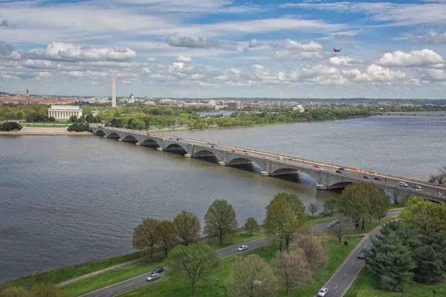
1932,1986,2019 Arlington Memorial Bridge over Potomac River at Washington, DC

(Bridge Hunter; Historic Bridges; HAER; Satellite)

"Built 1932; rehabilitated 1986; bascule span demolished 2019." [BridgeHunter] Joseph Strauss designed the movable span. Sheet steel cladding was added to the sides of the trusses to help them blend in with the concrete arches. [HistoricBridges]

HAER DC,WASH,563--5
5. South elevation. - Arlington Memorial Bridge, Spanning Potomac River between Lincoln Memorial & Arlington National Cemetery, Washington, District of Columbia, DC
 
National Park Service

HAER DC,WASH,563--29 (CT)
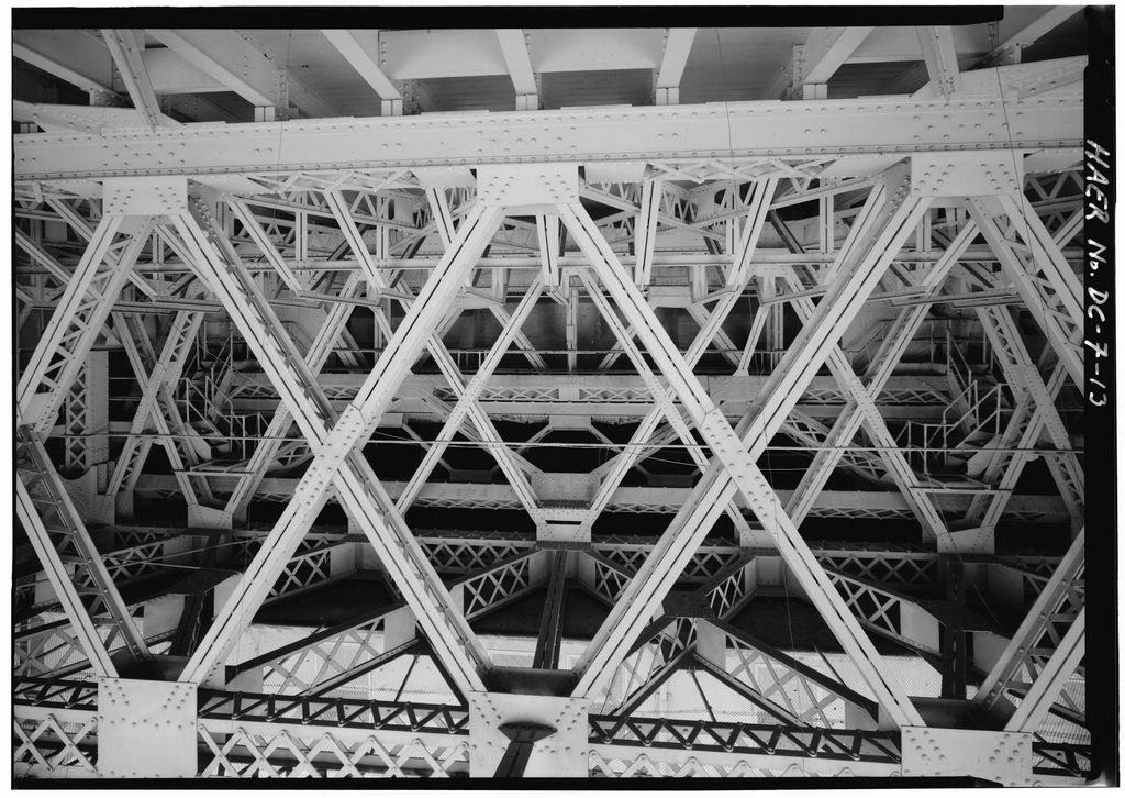
29. Interior view of eastern lift span, looking south.

HAER DC,WASH,563--13
13. Interior view of eastern lift span, with decking above, looking back from center of span, toward lift mechanism area. 

HAER DC,WASH,563--16
16. Interior view of lift mechanism area of eastern lift span looking south, showing trunion gears at left and right, and counterweight above.

Jonathan Konopka posted
Learned something new today. I did not know that the Arlington Memorial Bridge had a central bascule span that lifted up and down! I was trying to find better pictures of the span open, but all I could find was the one. The bascule span last opened in 1961 and was replaced by a span that doesn’t move in 2018.
[It appears Johathan copied this photo from HistoricBridges.]
 
This is higher resolution and has more information about the photo.
Photo From 1939 Thesis By R. W. Carroll via BridgeHunter

F Delventhal Flickr, License: Creative Commons Attribution (CC BY)
 
HAER-data, p120
Figure 4. Each leaf of the bascule span was assembled with rivets from components fabricated at Phoenix Bridge’s shop. The east leaf was erected first, and then raised to provide clearance for ships while the west leaf was being built. (NARA RG 42-AMB-1-30) 
 
Bridges Now and Then posted
"Washington, DC, circa 1930. "Construction of Memorial Bridge over Potomac River." (Acetate negative by Theodor Horydczak)

Historical Articles via HistoricBridges, p5

Historical Articles via HistoricBridges, p5
Street View, Oct 2018

Street View, Aug 2019

Street View, Oct 2019

Kiewit

asce
The steel-framed fascia of the bascule span was removed in four large sections to repair corrosion. (Photograph courtesy of AECOM)