Monday, March 4, 2024

1966 John Flannagan Dam and Lake Road Bridge on Pound River near Haysi, VA

Dam: (Satellite)
Intake Structure: (Satellite)
Outlet: (Satellite)
Spillway: (Satellite)
Bridge: (Satellite)

Google Search found several photos on USACE websites; but when I went to those sites, I could not find the photos.

The primary purose of the dam is flood control. John Flannagan was a Congressman that represented the area. [DickensonVA]

John W. Flannagan Lake, USACE posted
Today we wanted to do another “then versus now” photo to see where we’ve came from!  The top photo is from 1964 of the construction of the Junction Bridge and the bottom photo was from last fall! 
When the water is at maintenance pool, you can still sort of see the old roadway!  
[Google Maps doesn't know about a Junction Bridge. Is it the Lake Road Bridge?]

silent echo 0:15 video, Feb 2019
 
LoC
The dam is 250' (76m) high and 916' (280m) long. The outlet tunnel is 16' (5m) in diameter.

John W. Flannagan Lake, USACE posted
News article in The Herald Advertiser - Sunday, Sept. 18, 1966.
Announcing the Dedication Ceremony for John W. Flannagan Dam & Reservoir.
Did you know - "John W. Flannagan Dam paid for itself before it was even completed?"

John W. Flannagan Lake, USACE posted two photos with the comment:
These photos were taken in 1963 and 1964 of our intake structure during the construction of the project.  Did you know that the intake structure is equally as important as the dam itself for a lake?  While the dam provides a means for water storage, the intake structure allows us to control the amount of water released downstream, allowing us to not only prevent flood damages during high water events, but to also promote recreation downstream by fishing, kayaking just to name a couple! 
How many of you have driven by the intake structure or even toured it?
1

2


Sunday, March 3, 2024

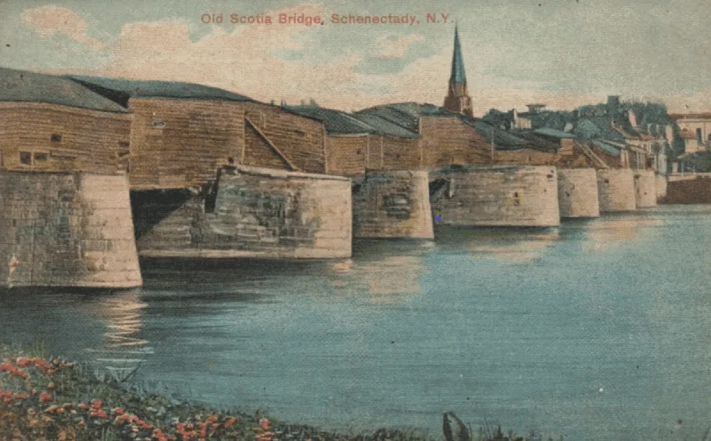
1808-74 Theodore Burr Bridge over Mohawk River at Schenectady, NY

(Satellite, based on the topo map below.)

NewYorkAlmanack (source), Courtesy of Schenectady County Historical Society
"The sinuous structure, which had been hidden for decades within the boxy covering. revealed three sets of laminated arches — flexible timber “cables” — that were clearly seen in Burr’s original drawing."

Theodore Burr was experimenting with different designs in the early 1800s. He didn't develope the arch-truss design that I associate with him until 1817. He had built a bridge here that used two 400' (122m) spans, but it came crashing down Feb 13, 1805. In 1808 he built a replacement that used four spans. It was essentially a suspension bridge that used laminated wood beams instead of metal tie-bars for the "cables." Originally, the piers at the bottom of the "cables" did not exist. They were added in 1835 because the suspension system was pulling apart. In 1874, this bridge was replaced by an iron truss bridge using the original piers. That bridge lasted until the 1930s. [NewYorkAlmanack]

Originally the bridge had just shingles on its "cables." By 1831, it had been enclosed.
NewYorkAlmanack, Courtesy of Ronald G. Knapp Collection

1893 Schenectady Quad @ 62,500

Saturday, March 2, 2024

NS/Nickle Plate Trestle over West Branch Conneaut Creek in Conneaut, OH

(Bridge Hunter broke Mar 22, 2023; no Historic Bridges; Satellite)

rtands (source)
Norfolk Southern completes Conneaut Bridge
"Located between Cleveland and Buffalo, the Conneaut Bridge is one of NS’s busiest bridges in the state, with approximately 20 trains crossing it daily. The existing 1,320-foot [402m] bridge was completely replaced with a new 1,300-foot bridge. The new structure is expected to last for 100+ years."

Photo via ConneautOhio

Norfolk Southern posted four photos with the comment:
Our Conneaut Creek Bridge replacement has been recognized by the Master Builders'​ Association of Western Pennsylvania, Inc.’s 2024 Building Excellence Awards for its outstanding design and execution! 🏆 
The Conneaut Creek Bridge, located on the Ohio-Pennsylvania border, plays a vital role in our rail network, connecting Cleveland and Buffalo with approximately 20 trains crossing it daily, making it one of the busiest rail bridges in the region. 
Working with contractor Mascaro Construction Company, LP and architect HDR, we replaced our original 1,320-foot bridge with a new 1,300-foot structure designed to last for more than 100 years— ensuring safe, reliable, and efficient operations for generations to come. 
Replacing the bridge, while limiting disruption on a key part of our network, was no small feat. This recognition is a testament to the expertise, craftsmanship, and collaboration that made it happen.  
Congratulations to the teams who made this achievement possible! 
Learn more about the project and award here: https://bit.ly/4idOA7J
📷: Mascaro Construction Company
Mascaro Construction Company, LP: Thank you for the opportunity to work with you on this project. It truly was a team effort, and we're very proud to have delivered a great experience for you and the community!
Bridges & Tunnels shared
1

2

3

4

Big Boy 2006:
James Guffey posted
Canadian National’s Bessemer and Lake Erie salutes the Big Boy at Conneaut, OH.
Will Astle: Great timing. Did CN stage?
Alex Holmes: Will Astle yes
R.B. Rail Photog shared


UP/D&RGW Bridge over Colorado River at Grand Junction, CO

(Bridge Hunter broke Mar 22, 2023; no Historic Bridges; Satellite)

Street View, Jul 2023

What a difference the lighting can make.
Street View, Jun 2018

Frank Keller Photography posted
On an overcast dreary day, the Montrose Local has an early departure from Grand Junction. The local is seen here crossing the Colorado River on a large truss bridge. Just to the left of the bridge is where the Gunnison River joins the Colorado River creating the junction. The tracks will follow the Gunnison River south got more than a few miles.
Roger Riblett shared


Friday, March 1, 2024

I&M Canal: Lock: #8, Aux Sable Aqueduct and Locktender House

Lock: (HAER; Satellite)
Aqueduct: (Satellite)
House: (Satellite)


Joe Balynas Flickr photo taken with a camera on a stick.
The lift is about 6.5' (2m). [JoeBalynas]

"The lift lock is one of the fifteen original deep-cut locks designed by William Gooding for the I&M Canal. The locktender's house was built in 1848 when the canal began operations." [HAER_data]

South elevation of the aqueduct. The arches are holding up the tow path.
Street View, Dec 2021

North elevation. The canal is in a metal trough. (If that metal is original, it would be iron. If it is a replica, it would be steel.)
Street View, Dec 2021

From left to right, lockhouse, lock and bypass channel.
Peter Ciro Flickr, License: Creative Commons Attribution-NonCommercial-NoDerivativeWorks (CC BY-NC-ND)
Aux Sable Lock #8 along the historic Illinois & Michigan Canal

Illinois and Michigan Canal Photo Tour posted two photos with the comment: "Lock 8 and bypass channel at Aux Sable, near Morris."
1

2

20140710 0051

The lockhouse is on the right and the bypass channel is behind the lock. Looking East or upstream.

Looking West or downstream.

The bypass channel had a weak current when I was there.

The lock has become a hodgepodge of repairs. This location is another demonstration that fish like turbulent water.

I need to make another trip to see if they fixed this sign since 2014.

This is a canal side view of the aqueduct.

The Dellos Road Bridge is not your usual UCEB (Ugly Concrete Eyesore Bridge). This was taken from the towpath on the aqueduct.

On the east end of the aqueduct towpath looking upstream.

On the west end of the aqueduct, looking downstream.

Taken from the bridge over the lock that we see in the above photo.

The concrete dam shows how the miter gates would look when they were closed. Unfortunately, that little flow is not enough to keep the "green stuff" off the canal, especially upstream of the aqueduct.

A photo dump of some photos of the aqueduct and arch bridge. I include a street view of the bridge to record how low the "handrails" are. I had recently taken photos from the Warrenville Bridge over the Tri-State and was scared by the low height of the handrails and the skinny sidewalk. But this bridge with no handrails and no sidewalk didn't bother me. Probably because the fall height was not too bad, and I didn't see a single car on the road while I was there.
Dennis DeBruler


Thursday, February 29, 2024

1869-89+1889-98 Falls View Suspension Bridges over Niagara River at Niagara Falls, NY

(Satellite, 300' (91m) north of the American Falls. [NiagaraFallsInfo] or
 Satellite, 14' (4.3m) downstream from the Honeymoon Bridge. [brocku])
 
Digitally Zoomed from the following photo

hmdb, cropped
"When it opened in 1869 with a 1,260-foot (384-meter) span, it was the longest suspension bridge ever constructed. The bridge was widened in 1888 to accommodate two-way traffic. On January 9, 1889, a strong southwest gale destroyed the bridge. It was quickly rebuilt and reopened on May 7, 1889."

The photo at the top of these notes shows the original timber towers. "In 1872, the sides were enclosed with wood and corrugated metal and a steam powered “Otis” elevator was installed in the Canadian tower to take tourists to an enclosed observation deck at the top of the tower. Tourists could then walk up a flight of stairs to an outdoor promenade on the roof of the tower. The elevator ride was priced at 10 cents." [NiagaraFallsInfo]
Patrick M. Sirianni posted
Wind Swept Bridges in Niagara and This Week in Local History.
No better time than today to mention the wind and its historical effects on the bridges and structures in and around Niagara Falls. Today marks the anniversary of the almost hurricane wind storm that would see the Falls View Suspension Bridge collapsing upside down into the gorge of the Niagara River just below the Falls on January 10th. 1889, and Dr. J.W. Hodge's near-death experience while crossing it.
That particular night, between Buffalo and Niagara Falls, railway tracks were covered with fallen trees and telegraph poles. Telephone, telegraph and electric light wires for miles in all directions were down. All passenger and freight trains were at a complete standstill as wrecking trains were sent out to clear the tracks. The water because of the force of the wind rose higher than it had ever since 1844. Quite a bit of the shore along the upper river and mouth of lake Erie were under three feet of water. A strip of land known as the Island was completely flooded and six homes at that location belonging to local fishermen have swept away.
Before I get into that tale, allow me to mention Reginald Fessenden and his experiences that he would later recollect crossing the then fairly new RR Suspension Bridge at the head of the Whirlpool Rapids.
Reggie's father was the first Minister of the newly constructed Christ Church located at the "Point" where Clifton Ave. meets River Road. The rectory at this time was located at the bottom of Queen Street and young Reggie attended DeVeaux School on the American side and crossed the bridge walking to classes every day. At a much later time, he wrote in his memoirs about his experiences crossing that sturdy structure.
"From home the walk was rather long and classes started early. In the fall the sun would be coming up just as I got to Mt. Eagle, and from there it was a lovely walk and a lovely site from there on., for the school was in the extensive and wooded grounds just at the Whirlpool Rapids. But in the winter it was much different. I had many bitterly cold struggles across the Whirlpool Suspension Bridge. Forcing my way into and across the heavy winds blowing down the Niagara Gorge, and having to hold on every now and then to the railing with both hands, but it was always a good fight and as a lad, I rather enjoyed it all."
Roebling's expertise certainly made for a sturdy two-deck Whirlpool RR Suspension bridge and I have never found any documents to ever state otherwise.
On the other hand, the Fallsview Suspension Bridge (considered to be the worlds longest Suspension Bridge at that time with a span of 1260 feet,) was built in the late 1860s by one Samuel Keefier and it certainly looked "shaky" enough to perhaps give one-second thoughts about crossing it on any sort of windswept day. In all fairness to Keefier, after its construction, the Falls View Suspension Bridge had been "tinkered" with on two different occasions. In 1872, the sides of the bridge were infused and a steam passenger elevator was installed in the Tower on the Canadian side. Then in 1887, the whole bridge was widened and this daunting task was completed in June of 1888. One can only contemplate the possibility that these two events could have been underlying factors in partially being responsible for its collapse.
Dr. J.W. Hodge was considered to be somewhat of an eccentric because of his decided opinions. He did not believe in God and was an affirmed agnostic at a time when religion was paramount to everything else in one's life. Some of his beliefs were quite unorthodox for the time as well, He was an anti-vaccinationist and was outspoken against efforts to immunize local residents during a smallpox epidemic and was also a great advocate for animal rights. According to his obituary, he was "for many years a relentless prosecutor of all those guilty of mistreating animals and was ever seeking to improve a lot of creatures which could not help themselves".
Perhaps what Dr. J.W. Hodge should have done was walk two miles and cross on the other during that late and stormy night's visit to the Canadian side to see a patient. Upon his trip back to the American side and most likely because his residence was located on Buffalo Ave., he decided to take the much shorter route and cross the Upper Suspension Bridge and save himself time and an extra four miles of walking. This ill-fated decision would almost cost him his life. Dr. Hodge in his own words:
"I had not advanced far beyond the Canadian Tower, however, before I realized from the nature of the swaying that something was wrong...As I neared the center, the swaying of the bridge was something terrific, and to add to the horror of the situation there was likewise a heavy motion like the rising and falling of a ship in the waves. .....Sometimes the bridge would seem to tip up as though one side was raised up by the wind, while the other hung from the 'suspenders' and whenever this occurred I dropped on my hands and knees for fear that I should be thrown over the railing. The rest of the time I clung to the railings as though it were the only straw between me and certain death, and worked my way along a few steps at a time whenever there would come a slight lull in the gale. To add to the discomfort and difficulties of the trip, great volumes of spray from the falls mingled with snow and sleet were dashed at intervals into my face, blinding me and drenching my clothing. At one point a gust of wind more powerful than the rest seemed to come swelling up from the water, and getting under my overcoat literally tore it open...
"Mingled with the whistling of the wind through the wires, when near the center of the bridge, I heard a sound like the flapping of a broken cable against the railing, and I believe it was here that the bridge began first to give way. When I finally reached the American towner, fully half an hour after I began the trip across, I was wet to the skin, almost blinded, and breathless. Nothing would tempt me to go through the same ordeal again"'.The bridge would finally give way on Jan. 10th at about 3;20 am. and Dr. Hodge was the last person to cross it before it collapsed into the river below.
Dr. Hodge continued to be a practicing physician well into his eighties and died on Feb. 18th. 1937 at 86 years of age. His body was cremated according to his wishes. He had written in his will "Having for many years been firmly convinced that cremation of the dead is the most sanitary, scientific and satisfactory method yet devised for disposal of human remains.....Furthermore, it is my ardent desire that no funeral service or religious rites of any sort be conducted over my body or the ashes thereof."
May be a black-and-white image of outdoors

Was this a predecessor bridge?
Peter K Burian posted
Originally called Elgin, the community merged with Clifton in 1856 ... 1881: name was changed from Clifton.
1848, first Suspension Bridge opens, for pedestrians, electric trams, and horse drawn carriages. At current site of Whirlpool Rapids Bridge
1855, Reconstructed bridge opens, two levels. Trains on the upper; vehicles and pedestrians on the lower level.
Artwork, by Charles Parsons, 1856

Peter K Burian commented on his post
>>> many local businesses wanted another bridge to be built closer to the Falls. >> Opened in 1869. Niagara Clifton Bridge, also called Falls View Suspension Bridge. >> Could accommodate the differing track gauges of the three railway lines >>> destroyed in a storm, 1889, ... a replacement was built in 38 days.