1908
University Heights: (
Archived Bridge Hunter;
HAER;
NYC;
Satellite)
NYC has some wide swing bridges because they use them for roads as well as railroads.
.
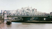
University Heights Bridge
"The University Heights Bridge, a steel Pratt/Howe truss, pin-connected, rim bearing swing span draw, with Warren truss approach spans, is one of the oldest swing-type bridges and the third oldest major bridge in New York City. It is the work of some of America's most prominent late 19th. century engineers. Although
the bridge originally was built at the northern end of Manhattan, continuing Broadway into the Bronx, it was moved to its present site in a complex process beginning in 1905. It is important as an example of circa 1900 bridge technology, and was a vital link in the extension of the Harlem River, which greatly contributed to the development of New York City. It was designated a New York City Landmark by the New York City Landmarks Preservation Commission in 1984." [
HAER_data]
 |
HAER NY,31-NEYO,178-
5. View looking south from Bronx (east) bank showing masonry approach ramp from Landing (exterior) Street. (Dec. 23, 1988) - University Heights Bridge, Spanning Harlem River at 207th Street & West Harlem Road, New York County, NY Photos from Survey HAER NY-199
|
 |
Jeffrey Gluck posted
University Heights Bridge (207th St./Fordham Rd.) |
 |
nyc
This 1,566' (477m) long bridge has a main span of 264' (80m). |
Christopher R Hernandez
posted four photos with the comment: "University Heights Bridge, Harlem River. Originally opened in 1895 near where the current Broadway Bridge is, it was relocated to its present spot and re-opened in 1908."
 |
| 1 |
 |
| 2 |
 |
| 3 |
 |
| 4 |
.
1901+2010 Willis Avenue Bridges
 |
Metrotrails posted
A view of the Willis Avenue Bridge over the Harlem River from the Manhattan side walkway. The original bridge was a swing span that opened in 1901. The replacement swing bridge was opened in 2010. Chris Gallagher: Unlike other Harlem River bridges, the Willis & 3rd Ave are one way traffic only. They became one way in early 1960's when the avenues in Manhattan became one way streets, before then they all had 2 way traffic, even narrow roads like 5th & Madison. Even the numbered streets were 2 way until the 1890's [Traffic on this bridge is from Manhattan to Bronx.] |
In 2010, a new span was floated into place. [
Flickr album description]
 |
1 of several photos of the new span being moved to the bridge site
[Obviously, here it is going under the Brooklyn Bridge.] |
Old span:
Jeffrey Gluck
posted two photos of the bridge replacement construction.
 |
| 1 |
 |
| 2 |
Third Avenue Bridge
I found this bridge when I investigated how cars that use the Willis Ave. Bridge would get back to Manhattan.
 |
nyc
The 2,800' (853m) long bridge has a 300' (91m) main span.
Recently, a $118m project replaced the 1898 bridge. |
This must have been the 1898 bridge.
 |
Bridges Now and Then posted
Southbound Third Avenue Bridge traffic, NYC, April, 1946. (Harlem River Crossways) |
 |
Jeffrey Gluck posted
Third Avenue Bridge |
Jul 8, 2024:
 |
NYC Fire Wire posted
Bronx *UNUSUAL INCIDENT* Box 8958 Third Ave Bridge BRIDGE IS STUCK OPEN DUE TO OVERHEATING. |
United States beauty
posted two photos with the comment:
The Third Avenue Bridge in New York City is a swing bridge that spans the Harlem River, connecting Manhattan to the Bronx. It carries five lanes of northbound traffic on Third Avenue, providing an important link between the two boroughs. Originally built in 1898, the bridge has undergone several modifications and reconstructions to accommodate the changing needs of the city, including a significant modernization in the early 2000s to enhance safety, durability, and traffic flow.
As a swing bridge, the Third Avenue Bridge can pivot to allow maritime traffic to pass along the Harlem River. Though it’s primarily used for vehicle traffic, the bridge also accommodates pedestrians and cyclists. Its structure, with an iconic steel truss design, reflects its historical roots while serving as a critical piece of infrastructure in modern New York City. The bridge’s strategic location supports not only local commuters but also provides a key connection for commercial and emergency vehicles between Manhattan and the Bronx.
 |
| 1, cropped |
 |
| 2 |
As a comment in the above post noted, you should not be spraying just the end of the span. The entire span needs to be cooled because it is the entire span that has expanded. Evidently none of the guys we saw on the span understand that it is the entire length of the span that has expanded. I quit watching after about his fifth "and again."


.jpg)


