Wednesday, August 26, 2015

Ohio River Tows

20150820,21 4195 12:24:18
When I first arrived at Fort Massac State Park to get west elevation pictures of the I-24 Bridge over the Ohio River, there was a tow going under the north arch. Even at this distance you can see big prop-washes for the twin screws. The towboat is having to use quite a bit of horsepower to shove the tow upstream.


I took a sequence of pictures because electrons are cheap and to capture a sense of how slowly it was moving.
12:24:50
12:27:52
12:26:24
Later, a construction barge was coming upstream. I waited so I could take a profile picture. As the time stamps indicate, it took a couple of minutes to move a few hundred feet.

12:41:28
12:43:30

12:45:28
As I was leaving, I took another picture upstream. The following are from that picture.

The tow we initially saw under the bridge seems to have stopped for now. I didn't think Lock and Dam #52 was still being used. It seems they are doing construction there. Maybe I-24 is not the only congestion because of construction. (Update: I was wrong. Lock and Dam #52 has evidently not been retired and they were using the lock during this visit.)

Under the bridge is a medium sized tow heading downstream. So tows in both directions are using the north channel.


And the construction barge is making good progress towards the bridge.

While I was taking pictures of the Metropolis Railroad Bridge, I saw that there were probably a lot of local river businesses because I saw a smallish towboat going upstream "light." That is, it was not pushing any barges. (The building on the left is the back of Harrah's Casino in Metropolis.) It would help breakup the big tows and deliver barges to their final destinations. And to build bigger tows by fetching barges from various area businesses.

Later when we crossed the Blue Hummer Bridge, my wife took some downstream pictures. She caught a 15-barge tow heading under the bridge. I analyzed the first tow I saw, and I think this is a different upstream tow.


Tuesday, August 25, 2015

I-24 over Ohio River, Revisited (My Photos)

20150820,21 4199cp 12:35:28
While driving to Kentucky, I had planned on getting off I-57 at the Metropolis exit. I was glad I did because traffic was backed up on I-24 to that exit. Once again, the I-24 bridge over the Ohio River had lane restrictions. Not only was traffic reduced to one lane; that lane was moving quite slowly. In the pictures above and below, I added a line above the cab of a Fed Ex truck because it was pulling two trailers and thus it is very distinctive in the pictures. It took 20 seconds to move 2.5 spans.

12:35:48
Many times in Illinois they will place the barrels to restrict the lane usage but when you finally get to drive through the construction zone, you not only don't see anybody working, sometimes you don't even see any equipment. I was not curious enough to see how many people were actually working on the bridge to go through the I-24 traffic. I used the  Blue Hummer Bridge to get to Kentucky. I had my wife take a picture on the bridge because this is the first time I have seen traffic on it. And it is probably the first time in my life that I was not keeping up with the flow of the traffic. I was a lot closer to the car ahead of me when we started across the bridge. But I was not obstructing traffic because the car behind me was going even slower.

In my original posting for this bridge,  I noted that barge traffic in both directions used the south navigation channel. On the day I took these pictures, barge traffic was using the north channel. I have no clue what influences a captain's choice of which arch bridge to go under. (Update: I have seen evidence that Lock and Dam #52 is still operational. During today's visit, they had to use the lock, which is on the north side of the river. During my previous visits the wickets were down so they had the option of using the south side of the river.)

I then put on the telephoto lens to get close up pictures. In the background of the middle picture you can see the Blue Hummer Bridge.


All of these pictures were taken from the Fort Massac State Park. When I first arrived, I could get only a fraction of the bridge with my wide-angle setting (18mm). Then I spotted a pier by a loading ramp. I was going to note the location of the pier in a Goggle satallite image, but it did not have the pier. So I switched to FlashEarth. All of the above pictures were taken from that pier. I then took pictures downstream and of the fort from the pier. While I was taking pictures, my wife went to check out the fort. But she was advised that it was closed because a fugitive was loose in the area. There is a bend in the river so that you can't see the railroad bridge in the downstream view.


Monday, August 24, 2015

Yorkville, IL, Dams (Drowning Machine)

20150720 3491, replacement dam and bypass from IL-47 bridge
There are a lot of little dams in Illinois because a dam was built in the 1800s to power a grist mill and/or sawmill. In fact, these dams would be the reason a town grew along the river. In the case of Yorkville, an 1837 survey indicates there was already a dam across the Fox River near the present dam location. In 1952 the Glen D. Palmer Dam was built with a five foot head. It had an ogee crest but little attention was paid to the footing of the dam. It scoured the riverbed and created a roller.
Photo from DNR
That is, the fast flowing water coming from the dam hit the slower moving water downstream and created a hydraulic jump or boil which shoved water up and back towards the dam at the surface. People and boats get shoved against the dam by this backwards flow and couls nor escape. Even rescue boats with a high powered motor are trapped up against the dam if they cross the boil. And the boat fills with water and the rescuers become part of the problem rather than part of the solution. Some web sites talked about the number of firemen that got killed as well as the original victims. For example, the Cedar Rapids dam.

USACE, Pittsburgh District posted
Everybody lock in. Let's talk about fixed-crest dams.
If that term means absolutely nothing to you, cool, let’s fix that. A fixed-crest dam is a step-like structure that runs across a river or stream to maintain a navigable depth in a once-shallow area. Fixed-crest dams usually have a pretty modest drop, somewhere around 1 to 15 feet, which sounds like they're not too big of a deal.
They are a very big deal.
Fixed-crest dams are infamous for the powerful recirculating current they create. Go over one and the current can keep dragging you back toward the base instead of flushing you downstream because regardless of whether or not you're wearing a life jacket or a strong swimmer, the current is stronger. Tragically, many victims are would-be rescuers. 
The trick of fixed-crest dams is that they're hard - sometimes impossible - to spot from upstream. They often create that smooth, calm “infinity pool” look, which is beautiful to look at right up until it's not.
Staying safe is always the top priority, and any step towards safety is a step in the right direction. Here are some tips to accomplish that:
So, how do you avoid getting introduced to one the hard way?
- Check maps ahead of time and ask locals where dams are
- Stay alert while you’re on the water
- Do not try to paddle over one. Turn around well before you get close
- Pay attention to warning signs and barriers
- Let someone know where you’re going before heading out
- If someone gets in trouble, do not jump in after them. Call 911 and use a rope or throw bag if you can help safely
Rivers are fun. Rivers are scenic. Rivers are not childproofed. Know what’s ahead before you head out.
Jim Graf: Dashields was notorious for people going over it cause they couldn't tell it was there,,glad you finally put up more markers.

A video in DamSafety explains a roller better than I can. It then explains how people can be rescued from a roller. The erosion of the riverbed downstream of the Glen D. Palmer Dam was so bad that it was replaced in 1960-61. But they still did not pay attention to dissipating the energy of the water so it also suffered from riverbed erosion and produced a roller. By 1978 there had been enough drownings that they placed riprap in the scour hole to stop the roller. But by 1991 the riprap had been scoured out and 26 more people had lost their lives at the dam.
Five different structural alternatives were studied to determine the best way to alleviate the safety problem at the dam. A four-step spillway design was chosen.

On the south side of the river, a 11,000 foot long bypass chute was designed for whitewater sport. A Denil fish ladder was constructed on the north side. (DNR)
A closeup of the bypass from the IL-47 bridge shows the pedestrian bridge that crosses the bypass.

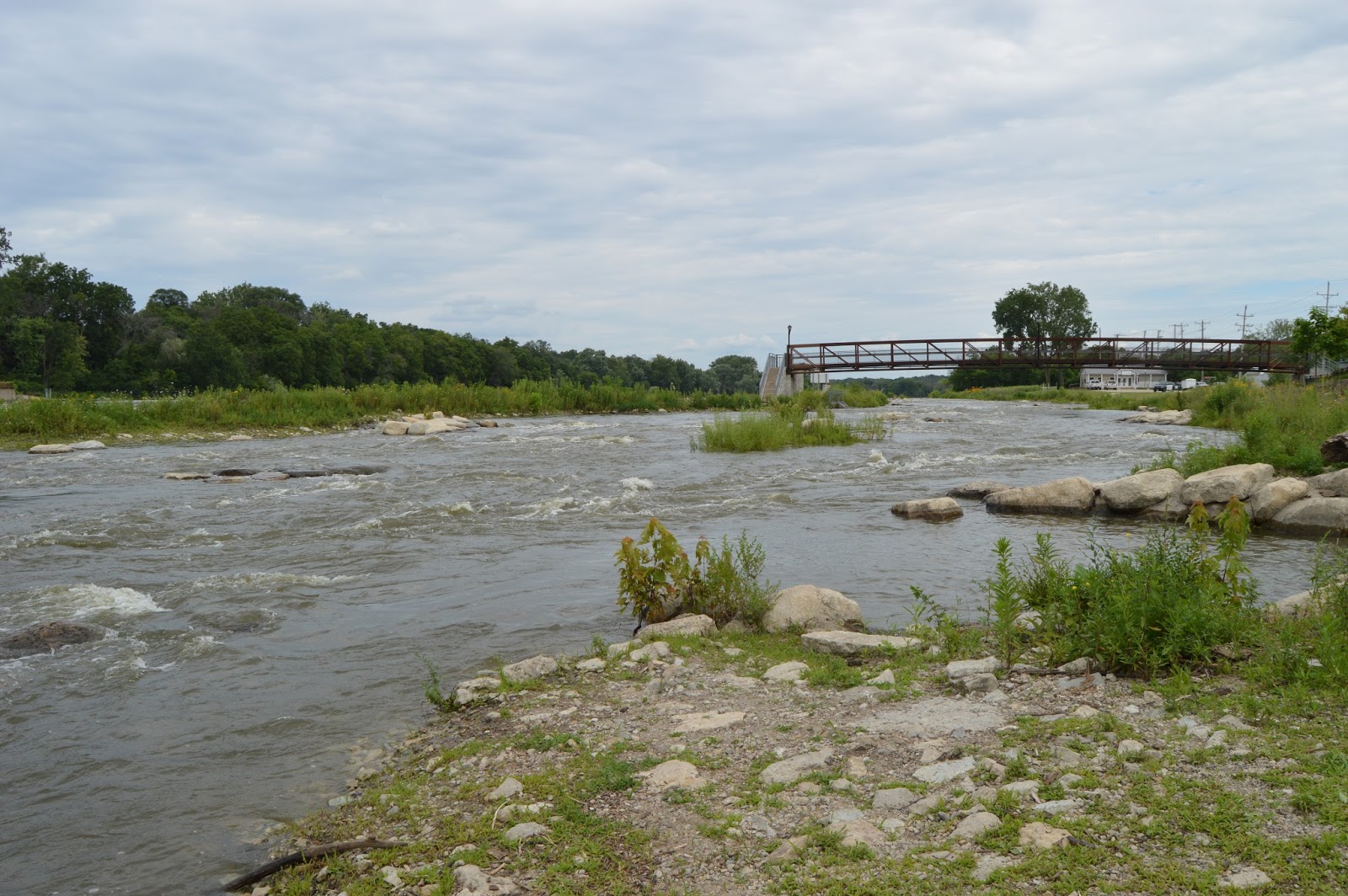
Below are upstream and downstream views from that bridge. You can see how they added rocks to create whitewater action. And you can see the IL-47 bridge in the background of the downstream view.


I then walked across the bridge and down to the end of the land between the bypass and the main river channel to take pictures facing upstream, 45-degrees, and 90-degrees across the bypass.

<
I then took three pictures from the shore to capture a waterfowl that was by the shore and then flew across the bypass as I walked by it even though I walked as far away from it as I could.


And then a couple overview shots upstream from the shore and then from a walk higher up in the park.


Update: More information on the danger of the rolling dam design.

Sunday, August 23, 2015

Maze Nails

Bird's Eye View
I went west on Water Street, Peru, IL, trying to follow the IR/.../CB&Q/IV&N tracks to see where they go. Unfortunately, Water Street rather quickly deadended. As I took side streets trying to get back to the tracks, I noticed a big industrial building with a sign of Maze Nails. Since it was a rainy day, I did not bother to take any pictures. Fortunately, the Bird's Eye View gives us a feel for what the building looks like. It looks modern enough that I would not expect to find it in a 1939 aerial photo, which is true. But we shall see there was an older plant off of Church Street.

20150808,09 3784
I knew Maze had a lumber yard down by the river because I took a picture to document their abandoned industrial spur. Did Maze make their own nails? Yes! They started the lumber business in 1848 and started making nails in 1886. In 1886, they made their cedar shingle nails from pure zinc rather than steel so that they would not rust and allow the singles to blow away. Their supply chain was short because Illinois Zinc was a few blocks east on Water Street and M&H Zinc was in the adjacent town of La Salle. (History)

1916 Sanborn Map, Sheet 7
In 1916, West Street went south across the Rock Island tracks to Water Street and W. H. Maze Co. had a plant just south of the tracks on the east side of that street that made shingle nails and glaziers points. Unfortunately, the scanning resolution of the map does not allow one to read much else.

1939 Aerial Photo from ILHAP
In 1922 they moved to a plant off Church Street. (History) I suspect that this 1939 image is of that plant. It has been replaced by the much larger plant pictured at the top of the post.

Nail manufacturing started out as a free inducement to buy cedar shingles and all of the other supplies needed for a job. But their zinc nails quickly grew into a separate business as other lumberyards took advantage of their access to the I&M Canal, riverboats, and two railroads to buy their nails. In 1914 they produced their first hot-dipped nails branded ZINCLAD. That is, they dipped a steel nail into molten zinc because the cost of zinc was skyrocketing. Not only did hot-dipping reduce their material costs, it made it easier to drive the nails because they had a strong steel core. In 1955 their engineers developed an automated nail dipping line to keep up with the demand. The line double dipped the nails to create their improved STORMGUARD nails. They added additional hot-dipping lines in 1972, 1988, 2006, and 2011. They have had several other innovations such as packaging nails in 50- and 5-pound boxes instead of 100-pound kegs and spiral shank nails.

They bought Independent Nail in 1990 and, according to their web site, are America's premier specialty nail company. According to Wikipedia, they are the only American nail company.

Update: A video of a machine that cuts nails.


Friday, August 21, 2015

Illinois Zinc and ACME Scales in Peru, IL

1939 Aerial Photo from ILHAP
(Satellite, 500 Brunner Street is the address given by the EPA.)

While researching a building that looked like it might have been a freight house, I learned that the industrial area between Water/Brunner Street and the IR/.../CB&Q/IV&N railroad was occupied by the Illinois Zinc Company in 1916. By 1939, much of the smelting operation had been torn down. But the rolling mill still looked operational.

I have not been able to find any additional info on Illinois Zinc. When I Google it, I get results for the other zinc smelting plant in La Salle, Matthiessen and Hegeler Zinc Company.


Michael Nieslawski posted three photos with the comment: "Few Zinc Works Shots."
1

2

3

Andy Zukowski posted
The Peru, La Salle & Deer Park Railroad
This Railroad had a little over three miles of tracks and sidings in Peru and entirely within the plant of the Illinois Zinc Company. This railroad had trackage rights on 0.230 miles of track of the CB&Q RR at Peru IL. It was controlled by the Illinois Zinc Company and the Railroad was incorporated on December 8th, 1905.

Andy Zukowski posted three images with the comment:
Illinois Zinc Company – Peru, Illinois
Origins (1870–1880s):  The Illinois Zinc Company was incorporated at Peru on February 3, 1870, with Pittsburgh capitalists Calvin Wells, Aaron French, William Mullins, James D. Layng and Ohio-born Archibald Means among the founding stockholders .  Its first plant on Water Street began with a single smelting furnace.  Rapid demand for “spelter” (high-grade zinc) spurred expansion – by the 1880s the Peru works had multiple furnaces and rolling mills. By 1939, much of the smelting operation had been torn down. But the rolling mill still looked operational.
1

2

3

I analyzed Sanborn Maps from 1888, 1897, 1906, 1916, and 1926. The apex of the plant was reached by 1916 and that configuration remained until 1926. The following two sheets are from 1926.
Peru, 1926 Feb., Sheet 011
Peru, 1926 Feb., Sheet 012

Comparing the 1909 and 1916 maps shows Kiln 4 and Furnace 1 were built during that interval. And the Oxide Storage building was added on the north side of the Acid Building.

There were significant changes between 1888 and 1889 and between 1889 and 1906 so I include both of the 1800s maps. Unfortunately, the clockwise rotation that I did on the screen is not reflected in the TIFF file that I downloaded. Also note on the 1888-06 and 1897-10 Sheets the "Chas. Brunner's Peru Foundry & Machine Shop M'rs of the ACME Scale." Obviously, the street along the river was named for Charles Brunner. I remember that the scale that was in the IC Freight House in Mattoon, IL, was an ACME Scale.

Peru, 1888 Oct., Sheet 006

Peru, 1897 Dec., Sheet 006

Peru, 1897 Dec., Sheet 010
Update:
Roger Kujawa posted
Illinois Zinc company Peru, Illinois early 1900's. Probably Rock Island or Burlington served industry.
David Lucas I'm glad I wasn't living downwind from that plant.
Harold J. Krewer This wasn't even the only zinc mill in the neighborhood...The Mathiessen & Hegeler Zinc Mill right next door in LaSalle was even bigger. Served by the LaSalle & Bureau County. There was also New Jersey Zinc down the river a ways in DePue.

Patrick McNamara commented on the above posting
The 1898 Rand McNally Railroad Map of Illinois shows Peru on the Illinois Central Main Line. http://www.idaillinois.org/.../collection/p16614coll7/id/17