Friday, August 27, 2021

1937 Mississippi Lock and Dam #18 near Gladstone, IL

(HAER; John A Weeks III; Satellite)

I have visited this dam a couple of times in 2013. During the second visit, I saw an interesting tow lock through. I describe that operation in these notes. We met some people on the visitor's deck, but they were interested in the eagles in the area, not the tows.

USACE-locking

This dam is similar to some of the dams further up the river in that the concrete part across the main channel is a small part of the total length of the dam. There is a submersible dike across the wildlife refuge and transition dikes on either side of the river. The maximum lift is 9.8' with an average lift of 6.9'. It takes approximately 10 minutes to fill or empty the lock. "The dam is composed of 14 submersible Tainter gates (20 feet high by 60 feet long) and three submersible roller gates (20 feet high by 100 feet long). All gates submerge to a depth of eight feet....Dams 11 and 18 were the first in the Rock Island District to employ submersible, elliptical Tainter gates. They were also the first dams in the District to use submersible roller gates. Four sites were considered for Dam 18: just below the foot of Otter Island at mile 406.5, immediately above the old mouth of the Henderson River at mile 412.0, near Oquawka and at the current site. The selected site called for diversion of the Henderson River to a point below the dam. The final site was partially selected because the Iowa River Flint Creek Levee and Drainage District No. 16 drainage pumps discharged into the lower pool and were unaffected by raising of the water level for the upper pool" [USACE-fact-sheet, p1]

Satellite

JohnWeeks

USACE, Rock Island District posted
Today [Sep 8, 2026] we celebrate the 89th birthday of Lock and Dam 18 on the Mississippi River near Gladstone, Illinois!
Construction on the lock at LD18 ran from January 1934 to April 1935 with work on the dam running from September 1935 through May 1937. The lock officially went into operation on September 8, 1937. Today, Lock and Dam 18 sees an average of almost 21 million tons of cargo annually.

Steve Vogt posted

HAER ILL,36-GLAST,1-
2. GENERAL VIEW OF DAM, DOWNSTREAM SIDE, LOOKING FROM GUIDEWALL - Mississippi River 9-Foot Channel Project, Lock & Dam No. 18, Upper Mississippi River, Gladstone, Henderson County, IL Photos from Survey HAER IL-29

HAER ILL,36-GLAST,1-
3. GENERAL VIEW OF LOCK, DOWNSTREAM SIDE, LOOKING FROM GUIDEWALL

HAER ILL,36-GLAST,1-
7. DETAIL VIEW OF DAM, SHOWING INTERIOR OF PIER HOUSE, LOOKING DOWNSTREAM

HAER ILL,36-GLAST,1-, cropped
9. PROGRESS ON PIERS. VIEW TOWARD IOWA SNORE FROM RIVER WALL (September 1936) 
=
USACE, Rock Island District posted
Today's #FlashbackFriday takes us back exactly 90 years ago today (March 27, 1936) to Lock and Dam 18 on the Mississippi River in Gladstone, Illinois. The photo shared here shows parts of the dam being constructed.
Today, an average of 20.8 million tons of cargo pass through Lock and Dam 18 annually.

USACE, Rock Island District posted
Today's #FlashbackFriday takes us back to April 1936 and the construction of the dam at Lock and Dam 18 in Gladston, Illinois! Stay tuned, because you might be seeing more of LD18 on our feed very soon!

USACE, Rock Island District posted
Happy Birthday [Sep 8] to Lock and Dam 18 in Gladstone, Illinois! On this date in 1937, Lock and Dam 18 opened for operation on the Mississippi River. For 88 years this lock and dam site has helped the navigation industry traverse the river and deliver products from producer to end user.

I'm saving this one because it explains some new terminology.
RiverWorks Discovery posted
Knock out Double Lock at Lock 18 on the Upper Miss
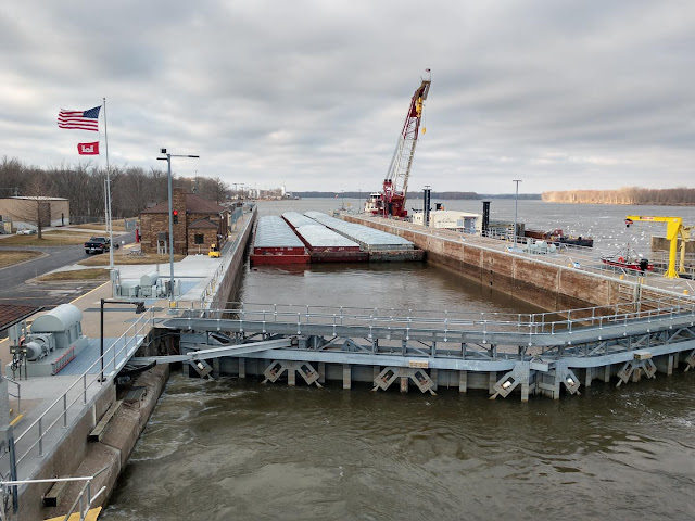
A double lockage with barges in the first cut and only the tow boat in the second cut is called a knockout double. The boat is unfaced from the tow (knocked out of tow) to allow the 600' tow to lock thru. 
It can also be called a "quick double" since facing the boat back up to the tow is considerably quicker than re-laying the wires at a barge to barge coupling.
Here we see Marquette Transportation's M/V Theresa L. Wood southbound with 8 loads at Lock 18 on the Upper Mississippi River mm 410. 
USACE's M/V Quincy is along with a gate lift/maintenance crane and support barges are tied off on the outer intermediate wall.
Courtesy of Capt John Vaughn.
Chase Gordon: First barge of the season. [Mar 9, 2022]

David Webster posted
Scott Bundy Springer: Lock 18


Thursday, August 26, 2021

CSX/ACL Bridge over St. Johns River (Lake Montroe) at Sanford, FL

(Bridge Hunter; Historic Bridges; Satellite)

Chris Ness posted
Sanford, FL ACL Drawbridge
Still active after all the years. I am told that it has as many as nine openings a day.
09/10
Dennis DeBruler
Thanks for contributing your photo to Bridge Hunter.
DS Hogan: Do they man all these railroad drawbridges? 24-7? How are they staffed?
Dennis DeBruler
Historic Bridges states:
"This railroad bascule bridge continues to carry many trains and also operates frequently for boats."
So it is probably staffed.

Dennis DeBruler commented on DS Hogan's comment
DS Hogan There is a human in the loop. But where that person sits can vary. In the case of RR bridges, it would be a railroad employee. I don't know about this Florida bridge, but some examples of bridge control are:
- For Amtrak's South Branch Bridge, call a phone number and it is operated remotely using multiple cameras.
41°51'21.0"N 87°38'13.2"W
- I can think of several lift bridges in the Chicagoland area where the conductor gets out and operates it. These bridges are normally open. I think the CSX/Rock Island bridge in Joliet is one of them.
41°31'14.9"N 88°05'16.5"W
- I think the NS/NYC Hick tower is still staffed (not manned) 24/7.
41°39'35.6"N 87°27'06.6"W
- The BNSF/SantaFe bridge across the Sanitary Canal is an example of a bridge that DOES NOT MOVE for marine traffic. I've watched them pump a lot of water into one end of a barge to get the load low enough to go under that bridge.
41°40'45.0"N 87°59'59.8"W
The towboats in Chicagoland have retractable pilot houses because several of the movable bridges no longer move.

Dennis DeBruler commented on DS Hogan's comment
DS Hogan I noticed a marina and houses that have water for their alley are upstream. And the satellite caught the bridge in the closed position. So it is probably staffed. I'm curious if it staffed 24/7 or only during the day.
28°50'20.4"N 81°20'01.8"W

Steven J. Brown posted
Amtrak Silver Star #91 crosses the St Johns River at Lake Monroe, Florida - January 25, 2022.
Steven J. Brown shared


WWII Navy Task Force 38

I don't do too many "one photo" posts. But I think this photo is worth it. I knew the US built a lot of ships for WWII. This photo helps me better comprehend the size of that war effort.
[Unfortunately, I forgot to record the source Facebook post.]


The US couldn't do this wartime construction again because we have lost too many of the industries needed to build big ships. Not only can China make 10 times more steel than we can, we can't build more steel mills. We have lost the companies like Mesta that make the machines that went into the mills. And we have lost companies like Verson Allsteel Press Co. that made the machines that formed steel into useful products. But it may not matter that the US can no longer tool up for a war effort because the next war may be fought in cyberspace rather than physical space. The loss of semiconductor manufacturing concerns me more than the loss of steel manufacturing.


Wednesday, August 25, 2021

(UP+Amtrak)/Southern Pacific Bridge over I-80 in Auburn, CA (BoB)

(Bridge Hunter; 3D Satellite)

BoB = Bridge on Bridge so that later I can find these more easily.

Jeff Lewis posted two photos with the comment:
How about a bridge supporting a bridge? Specifically a Pratt riveted deck truss supporting deck plate girder spans with deck plate girder trestle approaches? Meet the Auburn Ravine Bridge over Interstate 80 in Auburn, CA. The original deck plate girder bridge was built in 1912. I can't find a date when it was modified. Any info would be appreciated.
Aerial drone image ©Brad Fick, August 22, 2021
Historic image Brad Fick collection.
Brian Luna: It was modified in the 50s to accommodate I 80.
1

2

Facebook comments
Auburn Trestle
California Trestles
Chicago "L"

I don't care about the train, but I do care about the bridge.
River Rail Photo posted
Above It All In Auburn. Amtrak Train 5 (California Zephyr) had an extra and colorful addition to the head end, seen passing over Interstate 80 in Auburn, California on the afternoon of Friday, March 25, 2022. AMTK 90221 (F40NPCU, Salutes Out Veterans, formerly AMTK 221, F40PH) is 3rd out, behind P42DCs 202 and 45. NPCU means "Non Powered Cab Unit", as this former engine now only functions as a cab control car. It was with the consist from Chciago, Ilinois to Emeryville, California. The Placer County Museums/historic Auburn Courthouse is seen on the right of the photo, with its dome rising above the Auburn Historic District.
Flickr: https://flic.kr/p/2naLzWT

Aug 2025:
Facebook Reel

Tuesday, August 24, 2021

MWRD: Lemont Water Reclamation Plant (WRP)

(Satellite)

MWRD posted ten photos with the comment:
It was a little hot and humid this morning at Lemont Water Reclamation Plant but we were excited to learn about our new energy-efficient turbo blower, vortex separator and wet weather facility and other technology working diligently to treat wastewater for Lemont residents and protect the Chicago Sanitary and Ship Canal from pollution.
Today MWRD Commissioner Eira L. Corral Sepúlveda and staff members Julie Reschke and Yusuf Vidal and Justin Hart from the office of Commissioner Debra Shore were led on a tour by Lemont and Calumet engineers and treatment plant operators to provide a first hand account of the critical work Lemont WRP performs to transform up 4 million gallons of wastewater and stormwater into clean water.
Our new turbo blower at Lemont WRP will save nearly 400,000 kilowatt-hours per year for a savings of $27,613 per year. The blower produces twice as much capacity as the previous three centrifugal blowers and allows our operators to better adjust the air supplied to the treatment process and provide accurate dissolved oxygen levels in the tanks. The wet weather facility springs into action during rain events to mitigate combined sewer overflows.

1

2

3

4

5

6

7
[The BNSF/SantaFe bobtail bridge is in the background.]

8

9

10


Monday, August 23, 2021

1934 PAL/ICG/IC Big Clifty Bridge over Clifty Creek near Big Clifty, KY

(Bridge Hunter; no Historic Bridges; Satellite)

Jim Pearson Photography posted
Paducah and Louisville Railway loaded coal at Big Clifty, Kentucky
Paducah and Louisville University of Kentucky locomotives 4522 and 2012 lead the Louisville Gas & Electric loaded coal train across the trestle at Big Clifty, Kentucky as it heads north along highway 62 on its way to the Louisville Gas and Electric power plant in the Kosmosdale neighborhood of Louisville, Kentucky.
According to their website: “The Mill Creek Generation Station is LG&E’s largest coal-fired power plant, with a generating capacity of 1,465 megawatts. Mill Creek sits on 544 acres in southwest Jefferson County, Ky.
The late 1960s and early 1970s saw an unprecedented increase in the construction of new industrial, commercial, and residential facilities in the Louisville area.
As customers’ demand for energy increased, LG&E needed additional generating capability to guarantee supply and ensure reliability. Mill Creek began commercial operation in 1972 to meet this growing demand.”
Tech Info: Wide Photo: DJI Mavic Air 2 Drone, RAW, 4.5mm (24mm equivalent lens) f/2.8, 1/640, ISO 100, August 17, 2021.
Jim Pearson Photography
Lisa Ann Keown
Absolutely beautiful !! I've lived near this bridge my entire life and always wondered how it looked from above. ðŸ‘€ This bridge was built in 1934. It is 920' 6" long and sits 128 feet above Clifty Hollow! This is how the town of Big Clifty was born.
 
Redeker Rail Video & Photography posted
Was finally able to grab a shot I have been after for a while on the Clifty Creek trestle on the Paducah & Louisville yesterday. While working in the area the last few days I realized PAL4522 (UofK Basketball Championships Unit) would lead coal loads from McHenery Mine to Louisville Gas & Electrics plant near Kosmodale ( just outside Louisville). On top of that it was a cloudy day which would make a shot possible otherwise it would be extremely backlit when it crossed the trestle heading Railroad north(eastbound) around 2pm.. LG1 (assuming that’s the correct symbol) with PAL4522 on the point leads coal loads across the Clifty Creek trestle between Clarkson and Big Clifty Kentucky on September 15th 2021.

Terry Redeker shared

Most of the towers are hidden by trees. In this example. the girders across the towers are as deep as the longer girders between towers.
Street View


Sunday, August 22, 2021

1909 Plaquemine Lock in Plaquemine, LA

(Satellite)

This lock has been replaced by the Port Allen Lock. And the gate that used to open to the Mississippi River has been replaced by a levee.

Street View

Vaslis D., Aug 2020

LouisianaTravel
"Bayou Plaquemine was a natural choice for constructing a series of shipping locks in 1909, when business was booming on the Mississippi River and boats needed to get into and out of the nation’s interior. Plaquemine Lock was an unrivaled engineering marvel, capable of raising ships 51 feet — a world record at the time. [Some other sources qualify it as the highest freshwater lift.]
"During and after World War II, traffic became too heavy for Plaquemine Lock and a new dam at Port Allen was constructed, directly across the Mississippi from Louisiana State University. The old site was shuttered, but its memory lives on at Plaquemine Lock State Historic Site."

plaquemine
"Congress authorized the construction of a lock here in the late 1800s. Construction began in 1895 and was completed in 1909. In 1925, Bayou Plaquemine became the northern terminus of the Intracoastal Canal system. Increased river traffic during and after World War II put a severe strain on the lock's capacity. In 1961, the Port of Greater Baton Rouge opened in Port Allen and the Plaquemine Lock was closed after 52 years of service.
"It was designed by Col. George W. Goethals, who was later the chief engineer of the design and construction of the Panama Canal."

lastateparks
"In 1972 the Plaquemine Lock structure was placed on the National Register of Historic Places, an honorary designation for significant historic sites. In addition to the lock, the area includes the Gary James Hebert Memorial Lockhouse, which serves as a museum and visitors center. Hebert worked to prevent the destruction of the lock by the Corps of Engineers and campaigned to have the area preserved as a historic site. "

64parishes
"When construction on the Plaquemine lock began in 1895, the dynamite blasts were sufficiently powerful to cause structural damage to St. John the Evangelist Church.,,,The lock’s pump house has an exterior facing of white glazed brick, a material chosen for its ability to reflect light, as there were no lighthouses along the river. The lock house has large, round-arched windows and a cast-iron balcony; its prominent stepped gables are said to reflect the Dutch heritage of designer Colonel George Goethals (1858–1928) of the Army Corps of Engineers. Goethals later became the chief engineer for the Panama Canal and the first civil governor of the Canal Zone."