Wednesday, December 27, 2023

1938,2001 Lions Gate Bridge over First Narrows at Vancouver, BC

(Historic Bridges; Satellite, 13,261 photos)

Street View, May 2012

Alberta Dunns, Apr 2020

Old Vancouver Series posted
A promotional advertisement for the Lions Gate Bridge in 1939.
Bridges Now and Then shared

Navy General Board posted
HMCS Warrior passing under the Lion's Gate Bridge in late 1946/ early 1947.
[The description continues with a history of the ship.]

At first glance, I thought this was the same as above. But it is different.
The Warshipologist posted
A picture of HMS Implacable (R86) passing under the Lions Gate Bridge while departing Vancouver around October 18, 1945. She had just delivered POWs from Manila and was heading for Hong Kong for more transportation duties. A picture of the ship alongside in Vancouver can be found a little further down on the feed.

Ed Beauregard commented on the above post
The Vancouver City archives has an excellent collection of warship photos. Here is the U.S.S. Iowa passing under the Lions Gate Bridge July 7th, 1947. I actually have 16 mm film of the Iowa entering harbour, but sadly no 16 mm projector (sold that decades ago) so I never had a chance to digitize the video. Photograph by Walter E. Frost
 
John Merriam posted
Vancouver's Lions Gate Bridge.  This one goes back over 20 years.  It connects downtown Vancouver with North and West Vancouver over the First Narrows of Burrard Inlet.  The name comes from the twin mountain peaks to the north know as "the Lions".

Old Vancouver Series posted
The Lions Gate Bridge under construction facing North in 1938.   coloured by: Canadian Colour / photo credit: Vancouver Archives.
Bridges Now and Then shared

Barbara Budzynski posted
Lions Gate Bridge, Vancouver, from the air!
Bridges Now and Then shared

Bridges Now and Then posted
Lions Gate Bridge from Lumberman’s Arch, Stanley Park, Vancouver, BC, 1938. Photographer: Leonard Frank. (Jewish Museum & Archives of BC, Leonard Frank Photos Studio)
David Cooper: Financed by the Guinness brewery family to increase the value of their land the opposite side of the channel from Vancouver. Deck replacement design by Buckland and Taylor. Replaced entire deck piece by piece in overnight possessions in 2000...remarkable achievement.

Old Vancouver Series posted
Building the Lions Gate Bridge in 1938.
Khalid Ibraheem: Lions Gate bridge connect Vancouver city with North/West Vancouver and taking you to the ferries going to Nanaimo and Victoria, the capital city of British Columbia, Canada.
Bridges Now and Then shared

Bridges Now and Then posted
Vancouver's Lions Gate Bridge, October 19, 1938.
"OPERATING THE CABLE WRAPPING MACHINE
The cables were wrapped in the last month before the bridge opened. Here the three workers are operating a compressed-air-driven rotary machine. Workers were not issued any special clothing, footwear or safety equipment. None of these men is wearing a hard hat or a safety harness to catch him in case he loses his footing. They wore street fedoras or caps, and the man on the left is wearing soft shoes. A Maclean’s magazine article from August 15, 1938, illustrates the mindset of the workers who put their lives on the line daily. Any misstep at such heights could have meant serious injury or death. The reporter said of bridge worker Joe Lepage: “The expanse of space below him meant no more to Joe than the distance from kitchen porch to lawn means to the housewife as she hauls in Monday’s washing from the line.”" (Museum and Archives of North Vancouver)
Kip Wylie: In the 2000 In-depth inspection of the Tacoma Narrows Bridge we removed two sections of the wrapping cable, then probed to oak spikes deep inside the tranverse 8'300 support strands. With this the engineers were able to fiberoptic inspect for corrosion. To wrap our main cable we purchased an old antique 1940's wrapper from a bridge in NYC. That thing was by far the most cantancerous piece of equipment in 35 years of bridge work.
Dave Frieder: The POWER Wrapper was invented by Holton Robinson. He worked closely with David Steinman.
 
Eddie Gough commented on the above post
The same operation is used 18 years later , wrapping the Mac. Bridge main cable with galvanized wire. the main cable contains 12870 wires, no OSHA back then, 5 men did die during construction.

The bridge was named after two mountain peaks that are visible from the bridge. The sculptures were added to acknowledge the name. [study]
Street View, Apr 2023
 
StanleyParkVan
"When opened in 1938, the 1550 ft. [472m]  main span was the longest suspension span outside the United States....The total length of the Lions Gate Bridge (including approach spans) is 1517 metres [5154', 0.94 miles)]."
[There is no approach span on the south side because the bridge lands on a river bluff, but there is a long approach span on the north side.]

"This monumental and famous bridge retains its landmark status, despite severe alteration of the design of the bridge through loss of the original stiffening truss. The use of pony truss stiffening was a trademark and key feature of suspension bridges designed by the Canadian firm of Monsarrat and Pratley. In 2000-2001 the entire original stiffening truss system was demolished and replaced with a modern structure, that looks like an extremely shallow deck truss. The loss of original material as well as the replacement of the original design stiffening truss with an unusual design that looks nothing like the original engineer's design is a major alteration to this bridge and severely reduces its historic integrity. Also, another trademark of Monsarrat and Pratley, which was to use unusual paired suspenders with spacers was lost. The bridge still has unusual paired suspenders, but the spacers were not replaced. The spacers gave the bridge an unusual appearance." [HistoricBridges]

HistoricBridges
[This shows the spacers that were between the paired suspenders.]

HistoricBridges
The original truss.

Today, you can't see any of the new truss and there are no spacers between the paired suspenders. They also added a third lane by making the lanes narrower. The middle lane is normally reversed to accommodate rush hours. There is a pedestrian+bike lane on both sides.
Street View, Apr 2023

Tuesday, December 26, 2023

1879,2005 Old Appleton Bridge over Apple Creek near Uniontown, MO

(Bridge Hunter broke Mar 22, 2023; Historic Bridges; Satellite, 210 photos)

Street View, Sep 2023

nps by cmh2315fl is licensed under CC BY-NC 2.0
Old Appleton Bridge, Lewis & Clark National Historic Trail (4,900 miles (7,886km) long)
"Listed on the National Register of Historic Places the bridge crossing the Apple Creek was built in 1879 connecting Perry and Cape Girardeau Counties. The only iron bridge of its kind in Missouri still in its original location. But before the bridge gave life to the thriving communities on both sides of the creek, in the late 1790’s the Shawnee Native Americans discovered the Apple Creek and made their home here with one of the largest tribal settlements known as the La Grande Village Sauvage in Perry County. It was during this time that Lewis and Clark documented in their 1804 journal about meeting and trading with the Native Americans on the Apple Creek as they ventured up one Mississippi River’s tributaries."

HistoricBridges
Historical 1939 photo of bridge from Historic American Building Survey

2 of 24 photos posted by Drew Walters with the comment: "Pictures I took on December 21, 2023 of the 1879 Old Appleton Bridge in Old Appleton, Missouri. This is the oldest bridge I’ve photographed. Located just outside Perryville, the historic bridge was built by H.W. Sebastian & Co. of St. Louis. It was reconstructed in 2005 after being destroyed by a flood in 1982."
David LaBrot: My G-g-g grandfather operated a grist mill back in the 1820’s just to the right of that very bridge.
Drew Walters shared
a

b

VistPerryCounty
"Old Appleton Bridge is a historic Pratt Truss Iron Bridge located at Old Appleton, Cape Girardeau County and Perry County, Missouri. It was built in 1879, and consists of a wrought iron, pin-connected, Pratt through truss main span. It rests on limestone block masonry piers. The total length of the bridge is 161 feet [49m]. It was listed on the National Register of Historic Places in 2009."


Monday, December 25, 2023

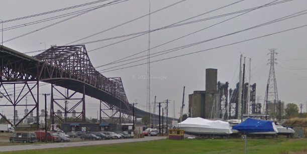
Skyway Yacht Works/Calumet Marine Towing on Calumet River in Chicago, IL

(Satellite)

James Davis posted, rotated
CMT yard early 1980s Calumet River, Chicago
Jason Bundy: Ol Barnaby's yard...
James Davis: Jason Bundy back in early 80s I’d go down Sat mornings-went on tows with CMT and GL !

Clarence Totleben commented on James' post, cropped
When I stopped by this past summer 2023.

Michael W. Cooked provided two photos with the comment: "When I worked there! 1991."
1

2

In 1985, Captain Ed Barnaby had nine tugboats in his yard. Business was already half of what it was two years earlier when they moved 4,000 barges on the lake. In 1985, only one of his tugs was working. [ChicagoTribune]

They have a crawler crane and a floating drydock.
Satellite

Another view of the crane and of part of the drydock. The towboat is Tanner. There is also an interesting trailer to the right of the crane.
Brandon Davis, Jun 2021
Obviously, this photo was taken from a semi-truck on the Skyway Bridge.

During the Winter months, they help provide storage for pleasure boats.
Street View, Nov 2017

I wonder why they rented a mobile crane since they own a crawler crane. Or did they get rid of that crane?
0:26 video, Jun 2020
"They’re coming from all over the world to sail in Chicago. Yuans 37 launched at Skyway’s Chicago Yard."


Sunday, December 24, 2023

1973 First (15 July Martyrs) Bridge over the Bosphorus Strait in Istanbul, Turkey

(Satellite, 44,640 photos)

Boat View, Dec 2014

This is another suspension bridge where the approach spans are supported by piers instead of cables.
Street View, Jul 2018
It has a LED lighting system, but it is normally red at night. "Today, the Bosphorus is an extremely busy shipping route, covering around 20 miles from north to south, and with an average of around 197 feet in depth. The widest point of the Bosphorus is a huge 2 miles, with the narrowest point just 500 meters....Around 140 cargo shipping vessels pass through the city’s waters every day, taking an average of 90 minutes each time." It handles 180,000 vehicles in either direction. [atriptoinstanbul] [So the sparse daytime traffic above must be a rare exception.]

Upon its completion in 1973, the Bosphorus Bridge had the fourth-longest suspension bridge span in the world, and the longest outside the United States" [google via Wikipedia]

Judging by the curve in the road, I think this photo is of this bridge.
Highway Engineering Discoveries posted
💠Istanbul , Turkey
Bosphorus Bridge in night
Suspension bridge in Turkey
📸 @tariksaroglu

Highway Engineering Discoveries posted
Istanbul 
Photo IG credit @mstfatyfn
 
Highway Engineering Discoveries posted
Istanbul

VisitingIstanbul
"It is a gravity-anchored suspension bridge with steel towers and inclined hangers. The aerodynamic deck hangs on zigzag steel cables. It is 1,560 m (5,118 ft) long with a deck width of 33.40 m (110 ft). The distance between the towers (main span) is 1,074 m (3,524 ft) and the total height of the towers is 165 m (541 ft). The clearance of the bridge from sea level is 64 m (210 ft)."
[I could not find an acknowledgement on this site, but all of the text was copied from Wikipedia.]

Bridges Now and Then posted
The Bosphorus Bridge, Istanbul, Turkey, viewed from Çamlıca Hill on the Asian side of the Bosphorus Strait, November 21, 2013. (Alexxx Malev)


Saturday, December 23, 2023

Great Northern's 6mw Tumwater Dam and Penstock Bridge

Dam: (Satellite)
Fish Ladder: (Satellite)
Bridge: (Satellite) It used to carry the water across the river. Now it provides access to the penstock trail.
Power House: (It was about 2 miles downstream from the dam.)

Street View, Jul 2023

CascadeLoop
GN built this powerplant to power its four electric locomoties that were used in its 1900 Cascade Tunnel to avoid the ill effects of smoke from its steam locomotives. "It was completed in 1909, and at that time it was the largest hydro-electric project west of Niagra Falls...The water ran through a 8-1/2 foot pipe made of wooden staves and held together by heavy steel cables. The powerhouse was made  of concrete and brick, and it housed three waterwheels and three 2,000 kilowatt generators."

When I read "waterwheel" on the above webpage, I wondered if they meant turbines. The statistics part of this plaque confirms it used  Francis turbines. And the power was 25hz since it was dedicated for use by traction motors.
 자유의 남자 JU IL, Apr 2023
The 8.5' (2.6m) penstock was 11,654' (3.5km, 2.2 miles) long.

Chris LeBoutillier, Oct 2021

The bridge is field-rivited rather than pin connected.
CascadeLoop

Friday, December 22, 2023

I-75+US-25 Clays Ferry 1869+1946+1998 Bridges over Kentucky River south of Lexington, KY

Old: (Bridge Hunter broke May 22, 2023; Historic Bridges; Satellite)
The 1998 bridge replaced the truss of the 1946 high-level bridge [HistoricBridges_new]
New: (Bridge Hunter broke May 22, 2023; Historic Bridges; B&T; Satellite)

The new bridge viewed from the old bridge:
Street View, May 2023

The old bridge:
Street View, May 2023

1869 Bridge:
HistoricBridges_old, Source: Kentucky Digital Library
[Historic Bridges gives this bridge its highest rating of 10/10 for both National and Local significance..]
This 1869 bridge has cast iron truss members. And the Warren truss is pin-connected. "Warren trusses usually have riveted connections.....The bridge was built in 1869 for the Richmond and Lexington Turnpike. The bridge was purchased by the State of Kentucky in 1929 and became part of US-25 until a larger high level bridge was built to realign US-25 in 1946. Since then, the cast iron truss has carried local traffic only. The bridge was rehabilitated in 1955. At some point, the top of the pier was removed and replaced with concrete. The primary substructure material is stone, although concrete has been used to repair the abutments as well."

HistoricBridges_new

Bridges Now and Then posted and kyphotoarchive_1944
"The Clays Ferry bridge was under construction over the Kentucky River in November 1944. The task of laying superstructural steel work on the pylons was done by the Mount Vernon Bridge Co. of Mount Vernon, Ohio. The structural work was started from the Fayette County side of the river and rose at a three percent incline to the Madison side. This slight grade can be seen in the photo. The bridge was 280 feet [85m] high at river level, the highest structure of its kind east of the Mississippi River at the time, and was more than 1,500 feet [457m] long. Published in the Lexington Leader." (Kentucky Photo Archive)
[You can see the old truss in the background.]

HistoricBridges_new explains that a parallel bridge was added in 1963. Then in 1998, when they replaced the trusses, they added the solid center piers and turned two 2-lane bridges into one 6-lane bridge.
Street View, Apr 2023

kyphotoarchive_1989, photo by Charles Bertrarn
"The bridge on the right was built in 1946 as a link over the Kentucky for U.S. 25. The bridge at left was added in 1963, and the two bridges became part of I-75."

HamburgJournal
"The Clays Ferry overlook wall was built in 1934, as a scenic overlook on the Old Dixie Highway."
The bridge is 250' (76m) above the Kentucky River.

1 of several photos on Bridges & Tunnels
Construction started in 1941, but it was slow because it competed with the war for steel and workers. In 1944, only 20 employees were working on the bridge.
[This webpage has a detailed history of the bridges.]

Salma Moli posted
Construction of Clays Ferry (Kentucky) bridge (1-75)

B&T mentioned that the old bridge is just one lane, so I took a closer look. That is quite a bit of traffic for a one lane bridge.
Street View, May 2023

April 2025 Flood:
Facebook Reel

Facebook Reel