Thursday, February 22, 2024

1870 Monongahela Incline (Funicular) in Pittsburgh, PA

(Satellite)
 
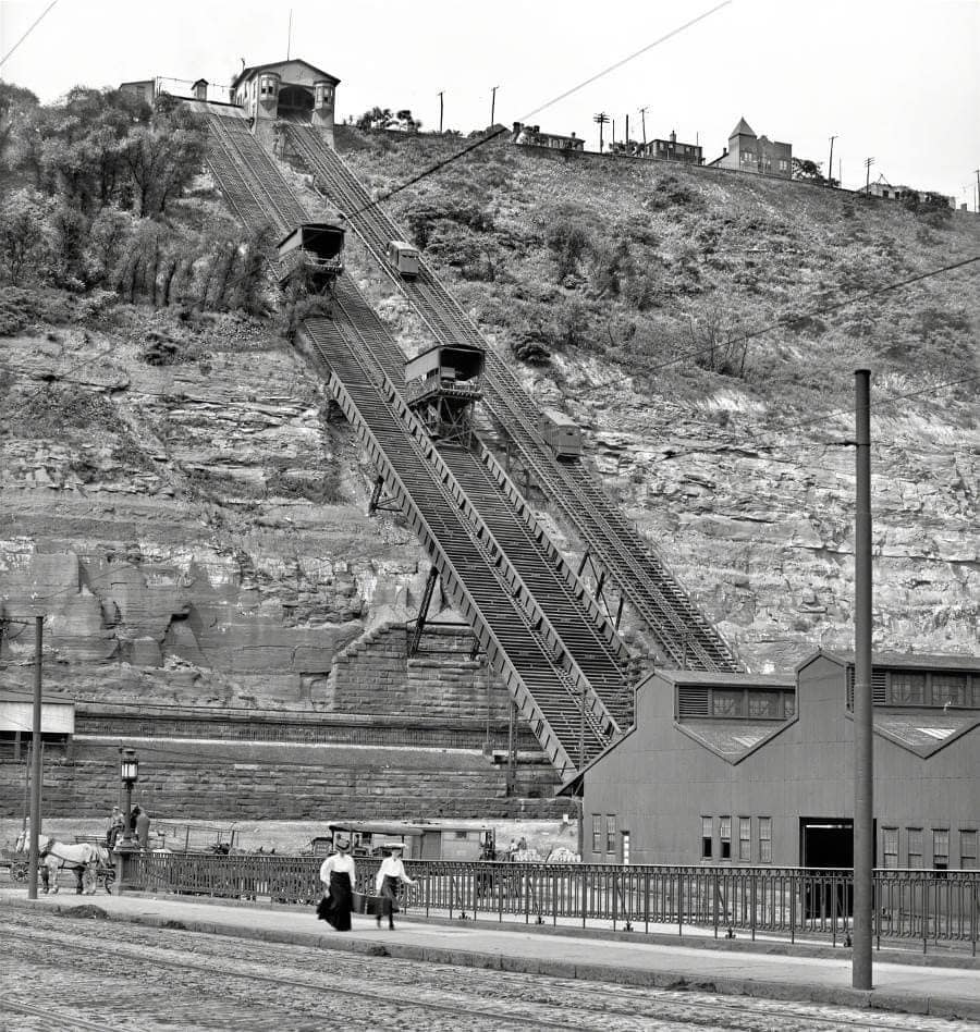
Civil War Pittsburgh posted
Opened in May 1870, Pittsburgh’s Monongahela Incline has been in continuous operation for 154 years. During the 28th Annual Encampment of the Grand Army of the Republic in 1894 the Incline not only served as a practical mode of transportation, but also shuttled onlookers and veterans to the peak of Mount Washington where closing ceremonies could be observed with a spectacular view.
[The comment continues with a description of the closing ceremonies.]
Fred Limbach: You can see the really big freight inclines to the left of the smaller passenger ones that survive to this day. My grandfather drove milk wagons on them in his youth.
𝗥𝗲𝗺𝗲𝗺𝗯𝗲𝗿 𝗪𝗵𝗲𝗻: 𝗣𝗲𝗻𝗻𝘀𝘆𝗹𝘃𝗮𝗻𝗶𝗮 posted
Monongahela Incline• Pittsburg, Pennsylvania • January 1905! 
(For those who aren't aware, it was Pittsburg in 1905 - formally reverting to PittsburgH in 1911.)
Frankly Words posted
The Monongahela Incline, up Mount Washington, Pittsburgh: showing the funicular railway that ran until 1935. Photo taken in 1905.

A postcard colorization of the above photo.
Shelly Ross posted
Monongahela Incline, Pittsburgh, Pa

The Untold Past posted
She wasn’t supposed to be an engineer.
 In 1870, most women in America weren’t even allowed to vote — let alone design a massive machine that would change a city forever.
That didn’t stop Caroline Endres.
 Alongside her father, John Endres, a Prussian-born engineer, she helped design the Monongahela Incline in Pittsburgh — the first passenger funicular railway in the United States.
It wasn’t just a marvel of engineering.
 It was a lifeline for the workers who lived high on Mount Washington and needed a safer way down to the factories along the Monongahela River.
Opening day, May 28, 1870, drew big crowds.
 At 6 cents a ride, 944 people took the trip — curious to experience the strange new “moving car” that climbed the hill at a dizzying 35-degree angle.
But the very next day?
 More than 4,000 people rode it.
 The incline became an instant success, carrying thousands daily, rain or shine, year after year.
Through wars, depressions, and the rise of automobiles, it kept running.
 Today, it’s recognized as a National Historic Landmark — still carrying passengers on the exact same route it did over 150 years ago.
And Caroline?
 She remains one of the earliest known women engineers in the country — her work still moving people long after she’s gone.
Would you ride something this steep… knowing it was built in the 1800s?
Dave Ford: Tracks on the left was for horse drawn carriages. Only the tracks on the right remain.
Ken Heitzenrater shared

WQED Pittsburgh posted three photos with the comment:
Often called the Mon Incline for short, the Monongahela Incline is the oldest continuously operating funicular railway in the U.S.  
Prussian-born engineer John Endres of Cincinnati, OH was commissioned to design the Monongahela Incline, which opened on May 28, 1870, as the first for passenger use. On the first day, some 944 fares were collected. (at 6 cents each!) But the second day, 4,174 people rode the incline & it became a success. He was assisted by his American-born daughter, Caroline Endres, who was educated in Europe & became one of the first women engineers in this country.
At a 35-degree grade, it’s one of the steepest in the world. It's recognized as a National Historic Landmark & as an historic structure by the Pittsburgh History and Landmarks Foundation
Alexis Zinovenko: It may be the oldest still in operation, but the Johnstown Inclined Plane is billed as the "world's steepest vehicular inclined plane". It can carry automobiles and passengers, up or down a slope with a grade of 71.9%.
[The Duquesne Incline is a few thousand feet downstream from here.]
1
Shelly Ross posted
Pittsburgh incline.
Jim McFarlane
Lenny Hendricks Vehicles, horse drawn wagons, bicycles etc. Keep in mind that there wasn’t a very convenient way to get up to Mount Wash when these were built. I’ve attached a link to a clip of an old episode of “Route 66” in which the boys took their 1961 ‘vette up the Castle Shannon Incline which was located just a short distance away from the Mon Incline…...just for reference!
https://fb.watch/u2OqQ_-bqc/?: Jim McFarlane - so was the second set of tracks for freight only?
Scott Rectenwald: Lenny Hendricks. Yes.
Jim McFarlane: Lenny Hendricks Vehicles, horse drawn wagons, bicycles etc. Keep in mind that there wasn’t a very convenient way to get up to Mount Wash when these were built. I’ve attached a link to a clip of an old episode of “Route 66” in which the boys took their 1961 ‘vette up the Castle Shannon Incline which was located just a short distance away from the Mon Incline…...just for reference!

2
[The bridge on the left is the Smithfield Street Bridge.]

3

Jackson-Township historical preservation posted
Passenger on the Monongahela Incline in Pittsburgh in the early 1880's. The photo was taken by Pittsburgh photographer, S.V. Albee. Built in 1870, the Monongahela Incline is the oldest continuously operating funicular in the United States.

Tony McCune commented on the above post
My shot.

Pittsburgh Regional Transit posted two photos with the comment: "Happy 153rd Birthday to the Monongahela Incline - the oldest operating funicular in the United States (opened May 28, 1870)!🥳🎈"
1

2

Wednesday, February 21, 2024

Lost/NP Saint Louis Bay (Rice's Point) Bridge over St. Louis River at Duluth+Superior

(Bridge Hunter broke Mar 22, 2023; John A Weeks III; Satellite, south abutment)

David Schauer posted
The year is 1973 and we are looking toward Duluth from Superior's waterfront. Canadian lakers are loading at the GN elevator (center) and Globe elevator (right). Two silver stackers of the U.S. Steel fleet are headed for the DM&IR ore docks while a pair of salties are at the port terminal. The open area in the lower left would soon become the Superior Midwest Energy Terminal to handle millions of tons of western coal through the Twin Ports. Burlington Northern's Wisconsin and Minnesota swing bridges are also visible (removed in the mid-1980s). Basgen Photography

JohnWeeks
[The NP bridge is in the middle by the grain elevator. The bridge behind that one was the Interstate Bridge.]

We can see both spans of this bridge in the left background of this photo. The swing bridge in the center background was the Interstate Bridge.
Chris Nylander posted
Note construction of the new High Bridge at top center.

Moose Mihalak posted two photos with the comment:
I debated posting these, since the rules mention far-off shots, but I wanted to show the old St. Louis Bay Bridge built by Northern Pacific on the west side of the Duluth harbor in St. Louis Bay, circa 1920.
Here we see the PM Interlake vessel JAMES C WALLACE heading for the then-DM&N ore docks. The crossing we see is on the south side, referred to as the Wisconsin Draw. 
The second photo is the Interstate Bridge connecting Duluth and Superior. Unfortunately, the photo was taken at an angle, and attempts to straighten it cut off much of the photo, so I let it be 
The St. Louis bridge is completely gone today, but the abutments can be seen off Garfield on the Duluth side, if one looks very closely. Part of the Interstate Bridge remains as a fishing pier and observation deck. 
Thanks to David Schauer for correcting my original bridge errors!
Unknown/my collection
1

2
[Per the description, this is of the Interstate Bridge.]

The grain elevator in the background is the 1898 General Mills/Great Northern Grain Elevator "S" and "X".
David Schauer posted
Amtrak's Northstar with a late morning arrival to the Twin Ports is seen crossing BN's Wisconsin Draw with the Great Northern elevator as an impressive backdrop. Superior, WI - early 1983
Steve Anderson: They blew that bridge up in 1984. I saw it on WDIO News.
Bradley Massengill: In superior / duluth, the passenger main line was pulled out along with Wisconsin and Minnesota drawbridges, so a ten minute crossing now takes an hour via grassy point drawbridge,
[So the southern swing bridge is called the Wisconsin Draw, and the northern swing bridge is called the Minnesota draw.]

According to John Weeks, the Interstate Bridge was built by GN and this bridge was built by NP.
1953 Duluth and 1954 Superior Quad @ 24,000

JohnWeeks
"This photo was clipped from the program for the dedication ceremony for the new I-535 Blatnik Bridge over the harbor connecting Duluth (on the near side) to Superior (on the far side). The Great Northern Interstate Bridge is located just to the left of the Blatnik Bridge. The Northern Pacific Saint Louis Bay Bridge is located on the right side of the photo. The Minnesota Draw swingspan is located in the foreground, while the Wisconsin Draw swingspan is located at the far right edge of the photograph."

Dyna Mike posted
This is looking east, the nearest bridge is the Rice's point bridge. It had 2 swing spans. The Interstate bridge is in the background.
John Soderberg: I used to walk out to this bridge to take guitar lessons from the bridge operator.
[This would be the Minnesota Draw. Note the Interstate span is already closing back into the closed position.]


Tuesday, February 20, 2024

1951 Wards Island/103rd Pedestrian Bridge over Harlem River in New York, NY

(Bridge Hunter broke Mar 22, 2023; no Historic Bridges; NYCSatellite)

How many pedestrian bridges in the USA, world, have a working lift span?

Street View, Oct 2016

nyc
The lift span is 312' (95m) long, and the sidewalk is 12' (3.7m) wide.
 
1 of several photos of the new span for the Willis Avenue Bridge being moved to the bridge site

1 of 4 photos posted by United States beauty
The Wards Island Bridge, also known as the 103rd Street Footbridge, is a pedestrian bridge in New York City that connects Manhattan to Wards Island, crossing the Harlem River. Opened in 1951, the bridge links East Harlem at East 103rd Street to Wards Island, which is part of Randalls and Wards Islands Park. The bridge is designed as a vertical lift bridge, allowing the central span to be raised for boats navigating the Harlem River.
Primarily used by pedestrians and cyclists, the bridge provides access to the parklands, sports fields, and recreational areas on Wards Island, as well as the island’s wastewater treatment plant and homeless shelters. The lift span of the bridge is rarely used, but the structure remains a unique feature among New York City’s pedestrian bridges due to its ability to accommodate river traffic.
The Wards Island Bridge is popular with joggers, cyclists, and residents looking for a green escape within the city. It provides a scenic route over the river and is one of the few pedestrian-only connections between Manhattan and the islands in the East and Harlem Rivers.

Metrotrails posted
Wards Island Pedestrian Bridge, originally known as Harlem River Pedestrian Bridge, completed in 1951. It connects the east River Greenway to Wards Island and Randall's Island Parks.
The center section is a lift span that allows for the passage of larger ships.
Seen from the walkway on Manhattan.
M'ke Helbing shared
 
Jeffrey Gluck posted
Ward's Island Pedestrian Bridge (103d St. Bridge)

The New York Landmarks Conservancy posted
Wards Island Bridge
The Wards Island Bridge, also known as the 103rd Street Footbridge, is a pedestrian bridge crossing the Harlem River between Manhattan Island and Wards Island. Completed at a cost of $2.1 million, it opened to pedestrians in 1951 and was later opened to bicycles in 1967.
The vertical lift bridge has a total of twelve spans consisting of steel towers and girders. Although originally painted in a red, yellow, and blue color scheme, it was repainted in sapphire blue and emerald green in 1986. After being closed to the public for approximately two years for a $16.8 million infrastructure project, Wards Island Bridge was reopened on June 1, 2012 and is open 24 hours-a-day year-round. Previously, the bridge had only been available for use from April through October during daylight hours.
Dave Frieder: Bridge was originally owned by the TBTA. Now owned by NYCDOT.
Engineer of design, Othmar Ammann. SAME engineer who was responsible for the engineering of the GWB [I presume the George Washington Bridge.]!
"The Wards Island Bridge is a pedestrian bridge over the Harlem River connecting the East River Housing Project at East 103rd Street in Manhattan to Wards Island. The view from Wards Island."

webpage with 9 photos

The navigation channel has a closed clearance of 55' (17m) and a width of 300' (91m). [WaterwayGuide]


This is one of the 2027 bridges in NYC. [nycbridges]

Monday, February 19, 2024

Historic Chicago Maps

These notes are dynamic in that I add maps as I find them. I try to add them in chronological order.

1718


Note the marking of the portages west and south of Fort Wayne, IN.
Paul Petraitis posted
1718

This map is even more confused about the rivers between the Great Lakes and the Mississippii River.
Newberry Library posted
When Europeans arrived in North America, they entered an established Native world. This 1718 map, based on the writings of French missionaries and explorers from the late seventeenth century, promoted the development of a French colony in the Mississippi River Valley. Chicago (Les Checagou) is noted as an established, inhabited place, and the surrounding names locate several Indigenous nations: “Nation de Feu” (Mascouten), “Grande Nation des Illinois” (Illinois Confederation, including the Peoria and Kaskaskia), and “Les Miamis” (Myaamia). 
The Chicago Tribune featured this map as part of Sunday's Fall Arts Preview highlighting our Indigenous Chicago exhibition that opens this week. The map was made by French cartographer Nicolas de Fer (1646-1720) and described as "The course of the Mississippi, or St. Louis, famous river of North America in the vicinity of which one finds the country called Louisiana." Publisher Chez J.F. Bernard, Paris 1718.
Paul Petraitis shared

1746


Joe Wheeler posted
“A Composite Map of the British Empire in America” 1746. From the David Rumsey Map Collection.

1830


Melanie Palen Shebel posted
Map of Chicago in 1830 
Melanie Palen Shebel shared
Bill Meyer: The dotted lines indicate what was present by 1884, for reference purposes, when the map of 1830 Chicago was made.

Terry Gregory commented on Melanie's share
This is a simplification of the map sourced and drawn by A. T. Andreas in his 1884 History of Chicago, Volume 1, pages 112-113

1833


Jasmin Rose posted
This is a map of Chicago from 1833!
Jasmin Rose shared

1834


Terry Gregory posted
On February 11, 1835, the Town of Chicago was Incorporated when the corporate limits were extended, so as to include all land lying east of State Street to the lake shore, from Chicago Avenue  and Twelfth Street. Previously the boundaries did not include the military reservation.
This  1834 survey drawn by J. S. Wright reflects the expansion.
Side note: Feb 11 is my birthday.

Bruce E. Jones commented on Terry's post
Very cool, lines up well with the 1833 map. I like the detail on the 1834 survey.

Terry commented on Bruce's comment
This map was designed by Walter Conley and drawn by O. E. Selzer for the 1933 Century of Progress Exposition. It was created after a two year search of libraries and archives and Miss Caroline McIlvane aided in the compilation when she provided details from the last surviving pioneers in 1900. The sketches were added to provide authenticity to the research. The map was published in the Chicago Tribune, August 13, 1933.

1836

 
Original Chicago posted
Map of Chicago Created by the Illinois and Michigan Canal commissioners and recorded on July 2, 1836
Glen Miller shared
This map mandates that a portion of the lakeshore be dedicated as "Public Ground. A Common to remain forever Open, Clear, & free of any buildings, or other Obstructions Whatever." Named Lake Front Park, this area was bounded by Randolph Street to the north, Madison Street to the south, Michigan Avenue to the west, and the lake to the east.
 

1857


Michele Ann posted
Vanished Chicagoland circa 1857...

1871


Jack Martillo posted

1888:
Daniel Bovino posted
Here’s a late 1880’s view of Roseland, Pullman, and the Calumet region. It shows a Lake Calumet in its original state and other lakes that have since been filled in. Hyde Lake is almost completely gone. Wolf Lake and Lake George have also been altered by the industrial push into this region over the last 150 years. Thankfully, some of our remaining area wetlands are under restoration. 
I received this wonderful map from Mendel Alumni, John Ormsby.
John Ormsby: Map taken from Library of Congress. Map Room in Jefferson Building
Paul Jevert shared
1880's topographical map of the southside at that time unincorporated into the City!

Jeff Nichols posted four pictures with the comment "1892 bird's eye map of Chicago. LOC."
1
2
3
4

1893
Jack Martillo posted

1926
Rachel Frundt posted

Evolution


Paulette Zemaitis English posted 
Found while researching my grandparents' residence in 1925.
Susan Kroll: These annexation dates are approximates, not exact. For more information, look at the Encyclopedia of Chicago. It has an online version.
Paul Walenga: Southwest side garfield ridge Clearing was 1915, 1918, and 1923. The huge 1890 was actually 1889.

Sunday, February 18, 2024

1957 Wuhan, 1995 Second Wuhan and 2011 Erqi Yangtze River Bridges in China

Erqi: (Satellite)
Wuhan: (Satellite, 1,595 photos)
Second Wuhan: (Satellite)

(First) Wuhan Bridge:
Y Hu, Jul 2019
 
hubei
When completed in 1957, this was the easternmost bridge on the Yangtze River. It is 1.6km (1mile) long with an upper deck for traffic and a lower deck for the Beijing-Guangzhou railway line.
 
ChinaDaily
There is a full-time maintenance team for the bridge. "Since opening, the designated speed of trains crossing the bridge has increased from 35 to 300 kilometers per hour, and the travel time from Wuhan to Guangzhou, Guangdong province, has been reduced from 44 hours to less than four."

I've heard that China has issues with air pollution, but I didn't realize how bad it was until I started looking at photos of these bridges. Is this pollution or fog obscuring the bridges?
cgtn
"The Wuhan Yangtze River Bridge was the very first bridge built on the river."


The Second Wuhan Bridge is in the foreground, and the Eriqi Bridge is in the left background.
全球全景, Mar 2019


Highway Engineering Discoveries posted

The Second Wuhan Bridge was completed in 1995. It is a " Cable-stayed bridge with semi-fan system" with 392 cables. The length of the main bridge is 1,877m (1.2mile). [ [strucurae]

ResearchGate
Yu, M. & Guo, Hang & Chengwu, Zou. (2006). Application of Wavelet Analysis to GPS Deformation Monitoring. 670 - 676. 10.1109/PLANS.2006.1650660. 

It has a central span of 400m (1312') and "bridgeheads" that are 90m (295') high. They give a figure of 392 cables. I think that is per bridgehead (tower). [hubei]


More fog or pollution?
LFI Gallery, cropped
It was completed in 2011. "The total length of the line is 6507 meters [4 miles], and the main bridge is 1732 meters [1 mile]."

"The 616m [0.4 mile, 2021'] long mid span ranking the bridge as the world's largest cable-stayed span with three towers, but also the longest span cable-stayed bridge with composite girder." [fidic_award]

fidic

Steve Chen via pexels, License: Creative Commons Attribution (CC BY)

It looks like salties can come all the way up the river to here. Part of the Second Wuhan Bridge is in the background.
Digitally zoomed to photo resolution

A Flickr photo that has a good view of the towers and of lots of ships.

I don't think fog would be orange. Are their steel mills in this town?
 全球全景_left, Mar 2022, Erqi Bridge

 全球全景_right, Mar 2022, Secon Wuhan Bridge