These are notes that I am writing to help me learn our industrial history. They are my best understanding, but that does not mean they are a correct understanding.
Wednesday, June 5, 2019
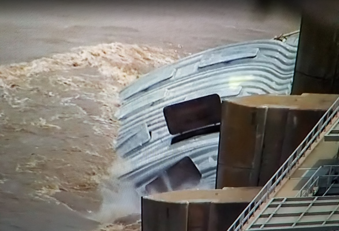
Flood of 2019: Two Barges Allided with the 1970 Webbers Falls L&D #16 on Arkansas River on May 23rd
Similar to the Marseilles Dam Accident, loose barges allided with the dam. In this case it was evidently two barges that broke loose from their moorings rather than four barges that broke loose from a tow. The entire town of Webbers Falls was already flooded.
Screenshot @ -0:15
Two barges on the swollen Arkansas River in Oklahoma broke free and slammed into a dam, quickly sinking under the force of the rushing water. Officials have evacuated homes in the area due to flooding.
[The footage at normal speed]
Brandon Phillips: That was Weber falls on the Arkansas river in 2019. It was not extremely dangerous. These dams are over built and designed to take an impact like that. The city emergency management director and police chief scared this entire town and forced in evacuation that was completely unnecessary.
The barges were carrying fertilizer. I-40 was evidently closed while the two barges were loose. After they hit the dam, I-40 was reopened. [NewsOn6-23]
This news report explained that years ago barge traffic took out a pillar and some spans of I-40 and there were fatalities. That explains why they now shut down the bridge if barges are loose.
(new window)
Note that this view also shows the Tainter gates are wide open. As I've described several times, but have not been able to show, the gates become almost horizontal and are out of the river's flow.
As the barges were floating downriver, evidently the news outlets were going nus about whether or not they would break the dam. And then they were so relieved when the dam was still standing after the barges hit. The foundations are built to withstand the pressure of the water when the gates are closed. Odds are, they are going to survive. But, as with the Marseilles Dam, the gates are another matter. Since these gates were all the way up, I expect they won't find any damage after they are inspected.
This overview of Oklahoma flooding is where I learned that Webbers Falls, which is downstream from the dam, was already flooded before the barge allision.
KOTV Screenshot @ 1:13
[All of Webbers Falls. OK, is flooded and could be for several weeks.]
1:06 video [The red one is disappearing under the water. Later in the video the white one disappears.] Brian Skidmore shared the power of water...wow!
Mar 2022 Update: when I came across a post of a video, at first I could not find these notes so I did some research for this L&D. Fortunately, I found these notes before I published the new notes, but I want to capture some of the additional information I found. (The video was redundant.)
Construction began in 1965 and it became operational in 1970. [USACE-history]
Representative flows selected and used during most of the tests were as follows:
a. Flow of 35,500 cfs with all flow passing through the powerhouse. This is the design discharge through the powerhouse and a river discharge that will be equaled or
exceeded about 15 percent of the time.
b. An intermediate flow of 80,000 cfs, which is equaled or exceeded about 6 percent of the time. This flow was tested with 35,500 cfs through the powerhouse and 44,500 cfs
through the spillway.
c. Maximum navigable discharge of 150,000 cfs, which is equaled or exceeded about l percent of the time. This flow was tested with 35,500 cfs through the powerhouse and the remainder through the spillway.
d. Flow of 1,200,000 cfs, which is the spillway design discharge.
I have never come across a nice summary like this before. We have add several big Winter storms this season that start in the lower plains and go Northeast through the Ohio River Valley.


Ugh, two barge loads of fertilizer will do wonders for the river. I suppose it will all end-up in the delta and cause more algae.
ReplyDelete