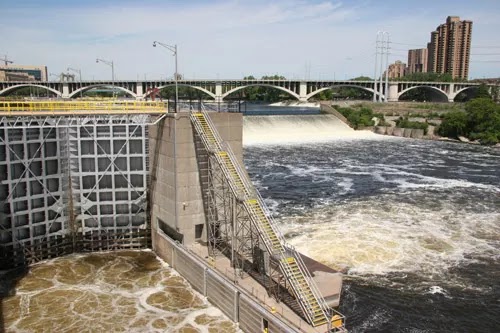
I combined the dam and bridge notes because many photos include both.
I start with a satellite image to describe the layout. Understanding the layout makes it easier to place the photos. The big white stripe in the middle of this image is the main spillway with a 40' drop. The V-on-its-side just upstream is an apron the USACE built to cap the rock to stop the erosion of the falls. It is another 10' drop. Minneapolis became a large four mill center because these falls had nearly 50,000 horsepower of energy. [John Weeks L&D] South of the main spillway is the channel for the lock. Below that is a visitor center and the Great Northern Stone Arch Bridge, which has been turned into a trail. Below that we see a remnant of a millrace.
 |
| Satellite |
Above the spillway in the overview is a headrace. On the south side of that headrace is the St. Anthony Falls Laboratory that was founded in 1938. The lab uses the 50' drop at the falls to provide water flows for experiments and simulations such as the affect of removing a dam. The green area to the left of the lab would be the outdoor test channel and stream simulation facilities. [John Weeks Lab] The building at the end of the headrace is the powerhouse. It was built in 1908 to supply the streetcar system. Now it feeds 12 MW to the grid using five generators. [John Weeks Power]
 |
| 3D Satellite |
 |
| USACE "Dam consists of a horseshoe dam with a chord dam downstream of the the horseshoe and a concrete overflow spillway owned by Xcel Energy Center." |
"The US Army Corps of Engineers closes the locks to recreational users when the flow hits 30,000 cubic feet per second, and closes to commercial traffic at 40,000 cubic feet per second." [John Weeks L&D]
 |
| John Weeks L&D [Of course, the main spillway is across the middle of this photo. The Third Avenue Bridge is behind that. And the 10' drop of of the "V" is visible as white lines under the bridge.] |
 |
| Bridges Now and Then posted Construction on the 3rd Avenue Bridge, Minneapolis, Minnesota, c. 1917. IMinnPost) |
 |
| Bridges Now and Then posted Third Avenue Bridge construction, Minneapolis, Minnesota, 1917. (Mill City Times) |
An upstream view from the Hennepin Avenue Bridge shows the navigation channel under the right-most arch and the turbulence of the "V" in the middle.
 |
| Street View |
When you have a 50' drop, the gates on the lock are rather big.
 |
| John Weeks L&D |
 |
| nps This dam has a visitor center. "With a lift of 49 feet, the lock at St. Anthony Falls accounts for more than 10% of the total height change of the Mississippi River between the Twin Cities and St. Louis, MO. In 2015, the Upper St. Anthony Falls Lock and Dam closed to river navigation." |
Melody Chamberlain posted two photos.
 |
| 1 |
 |
| 2 |
If you look at the satellite image you can see the bridge curves. John Weeks and Historic Bridges explain that one reason was to locate the piers on solid rock. They had to avoid building a pier on fractured rock. But another reason is that Third Avenue does not align with Central Avenue. "The Third Avenue Bridge is the longest S-curve shaped concrete arch bridge in the world." [John Weeks Bridge]
 |
| John Weeks Bridge |
 |
| John Weeks Bridge |
In 1939 a new deck was built. It widened the deck to replace two streetcar tracks, two traffic lanes and two pedestrian lanes with four traffic and two pedestrian lanes. [John Marvig]
A rather rare view of the upstream side.
 |
| One of three photos posted by Cory Parkos |
 |
| MPRnews, one of 11 photos in a gallery "Upper St. Anthony lock closing after half a century; blame the [Asian] carp" It closed in 2015. This article has a nice history section. |
 |
| safe_image for Potains built into bridge restoration |

The 3rd last post The low angle light from the sun was able to get in behind the concrete supports and light up the inside of the bridge. Now its time to avail Taxi Near Mefor more details.
ReplyDelete