North Caroline Cut: (Satellite, between Coinjock Bay and North River.)
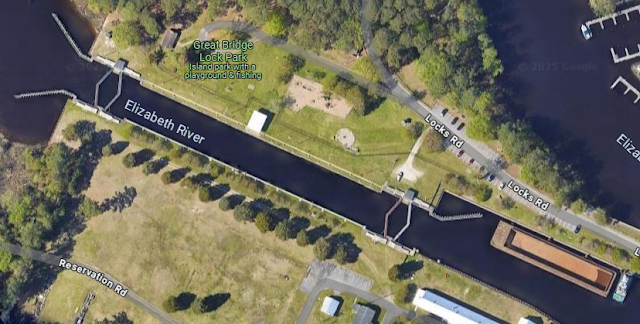
Lock: (Satellite)
Bridge: (Satellite)
The lock is more of a guard lock; that is, it doesn't have a lot of lift. The boat on the right is in the lock. On the right side of this view, we get a glimpse of a boat in the lock.
 |
| Street View, Aug 2023 |
 |
| carolana |
The lock is "a reversible guard lock with double gates at each end of a 220-foot long chamber....The guard lock, reconditioned in 1973 and floored, is unique since it handles alternate heads of water from west and east in the tidal Elizabeth River and fresh water from the North Landing River." [carolana]
 |
| Satellite |
 |
| 1902/23 Norfolk Quad @ 125,000 |
The 75 mile canal had to cut through just 14 miles of land. "The Virginia cut was 8.45 miles long, and the North Carolina cut was 5.6 miles long....The United States government acquired the Albemarle & Chesapeake Canal in 1912 and improved it, first eliminating the guard lock, then in 1932 replacing it with the present six hundred (600) foot steel and concrete guard lock. The channel was dredged and maintained for a twelve (12) foot draft. Covering a distance of almost two hundred (200) miles from Norfolk, VA to Beaufort, NC, the waterway varies in bottom width from ninety (90) feet in land cuts to three hundred (300) feet in open waters. Between 1970 and 1979, commerce on the Albemarle & Chesapeake Canal portion of the Intracoastal Waterway averaged roughly 1.4 million tons annually." [carolana]
The bridge was built by the original Norfolk Southern, not today's NS. The bridge is now owned by the Chesapeake & Albemarie Railroad.
Some of the views do show it is used by commercial traffic. For example:
 |
| Street View, May 2018 |
A train must be close to the bridge because the bridge is not in the raised position.
 |
| Street View, Mar 2023 |
.jpg)
No comments:
Post a Comment