Sunday, October 5, 2014

NKP: Nickel Plate Road, LE&W and Cloverleaf Overview

Update: see Delphos, OH, for a history of the Cloverleaf by Mike Snow.
Update: the labels abanCloverleaf and abanNKP-LEW have been defined to identify towns in the Towns and Nature blog that were on these abandoned routes. Example are Cowden, IL and Paxton, IL.

It started operation in 1881. [american-rails]

Map via NKPHTS

Nickel Plate Road was the popular name for the New York, Chicago and St. Louis Railroad. The reporting mark, NKP, was based on the nickname. While I took a trip along Indiana State Road 28, I knew I was going along a Norfolk Southern track because of my stop in Frankfort to take a picture of a coaling tower. In one of the towns I saw a street name of Nickel Plate. The Nickel Plate got absorbed by Norfolk Western which then became part of Norfolk Southern, but I was surprised that the NKP was this far south. My home town is Fort Wayne, IN, and I knew that NKP's mainline went across northern Indiana. On my trip back, when I spotted the Nickel Plate engine in Tipton, IN, I knew it was time to research the NKP when I got home. A system map shows that the NKP tracks were all over the northern half of Indiana. I'm reminded that before trucks and paved roads were developed, a lot of railroad routes were needed. The four districts gave the NKP system access to several gateway cities -- Chicago, Peoria, St. Louis, Indianapolis, Buffalo, Pittsburgh, and Wheeling. It benefited from good management and became a strong bridge system. The Clover Leaf District would be why St. Louis is in the railroad's official name.

The railroad industry started another round of mergers in the 1960s. For example, NYC+PRR -> PC, Erie+Lackawanna -> Erie Lackawanna and B&O+C&O -> Chessie. Since the Norfolk & Western wanted its own access to the midwest and Chicago, it agreed to merge with the NKP. The 1964 merger also absorbed some smaller systems that asked to be a part of the merger. Those systems were the Wabash; Akron, Canton & Youngstown, and Pittsburgh & West Virginia. (AmericanRails) The Norfolk & Western, in turn, became part of the Norfolk Southern.


Rails and Trails

Jimmy Fiedler posted
Kevan Davis: Somebody explain why gm&o and Erie Lackawanna is on this map?
David Jordan: The Clover Leaf (TStL&W) was allied with the Chicago & Alton RR and parent company until 1921 or so. I believe the Van Sweringens tried to gain control of the Erie RR in 1925-1926. Other than that...

Michael Maitland posted
Going thru some old maps I either picked up at shows, or from the many books purchased over the years (not sure what book this may have come from-apologies) Interesting to see what became of some of the older components. Think the LE&W was called the "clover leaf" and could barely hang on. The T, StL and W was originally a lightly built narrow gauge. North south feeders. Not much left except the NKP and DTSL.
Dennis DeBruler: It was the TStL&W that was called the clover leaf: https://www.nkphts.org/map. I did not know that Detroit & Toledo Shore Line became part of the NKP.

(The above maps make the following ones obsolete. But they were a lot of work, and I can't force myself to delete them)

The route that parallels IN-28 and the route that crosses IN-28 in Tipton are part of the Lake Erie & Western District. To help determine who now owns which segments of the NKP in Indiana, I first augmented the INDOT map with Paint to highlight the different districts by adding colored lines using the colors of the system map. The lines are below or to the right of the NKP lines.

Blue is the NKP mainline, yellow is the Lake Erie & Western, and green is the Toledo, St. Louis & Western, nicknamed the Cloverleaf. Both the LE&W and Cloverleaf were absorbed by the NKP in 1923. (A Railroad Atlas of the United States in 1946, p viii.)

INDOT plus Paint
In the "now" maps, I do it by districts to avoid running out of colors. The Nickel Plate District is easy -- it is now all part of the Norfolk Southern.The Clover Leaf District is now NS (blue), Central Railroad of Indianapolis RR (green), Wabash Central RR (yellow), and Unknown (black).

INDOT plus Paint

The Lake Erie and Western District is now NS (blue); Chicago, Southshore, & South Bend RR (yellow); Fulton County RR (orange); Hoosier Heritage Port Authority (red).
Kankakee, Beaverville, & Southern RR (green); C & NC RR (pink); and Honey Creek RR (black). (Update: details concerning the Peoria Division of the LE&W. The current status of the entire east/west route)
INDOT plus Paint
The Nickel Plate was built between 1881 and 1882. That was late during the railroad building era. The NKP got through Fort Wayne by buying the path of the Wabash & Erie Canal, which was abandoned in 1874. (archfw) For decades, I have been curious how the NKP gained access to Chicago. I found the following map in a discussion of the LaSalle Street Station. The NKP line paralleled the Illinois Central line and then joined the Lake Shore and Michigan Southern Railway, which was part of the NYC system. Initially it used the NYC track to get to its own depot at the northwest corner of Roosevelt Road (12th Street) and Clark Street. Soon after the NKP was built, NYC gained control of it to kill the competition, and then NKP was allowed to use the LaSalle Street station as a tenant. In anticipation of the implications of the Clayton Antitrust Act, NYC sold the NKP in 1916, but it continued to operate into LaSalle until the end of NKP passenger service.

Wikipedia


Satellite

The south part of the passenger service route still exists to serve industry along the track. But most of the passenger extension has now been torn up. But you can still see a land scar of the old route in a satellite image. The image to the right indicates the abandoned trackage with the red line. All of the remaining trackage of NKP in the Chicago area is now owned by and operated by the Norfolk Southern.

Update: Pictures of the north/south route in Sharpsville, IN in Facebook. The comments provide more information. Info on the abandonment of the Cl;overleaf in Ohio in Facebook.

Posted by Jacob Hortenstine and enhanced by Tom Watson in Facebook
Van Buren, IN

While studying the ownership of a lost bridge in Sandusky, OH, I found a couple of histories of the LE&W: akronrrclub and  nkphts. Of note, NYC bought LE&W in 1900 but never integrated it into the NYC System. In 1922 it was merged into the Nickel Plate Road and became the Lake Erie and Western District.

Raymond Breyer posted
Dennis DeBruler I needed a reminder that Cloverleaf was a nickname for the Toledo, St. Louis & Western. In fact, I just had to look up what NKP was a nickname for: New York, Chicago & St. Louis.


Mike Snow posted an extensive comment about the Cloverleaf history.

gorail


Friday, October 3, 2014

Nickel Plate Engine 426

Update: HHR is the reporting mark for Hoosier Heritage Port Authority.

I was driving westbound on Indiana State Road 28 during the evening of August 30, 2014, when I noticed a NKP engine setting next to a crossing in Tipton, IN. Fortunately, traffic was light, and I was able to quickly make a left-hand turn into a parking lot next to the tracks. It had started to move so I grabed this picture.

20140830 0073

Realizing I was on the dark side, I quickly ran around to the other side grabbing this photo as I went since I was "loosing" the train. When I pulled into the parking spot, I could see through the open door in the first car that it was some sort of "support" car. Maybe it contained a Head End Power generator and/or tools.


There was not much train and sun left by the time I got to the other side. There was time to zoom from wide-angle to a normal lens.


I digitally zoomed-in on the "farewell" shot. I assumed I had seen a railroad museum train. An Indiana map indicated that the track segment from Tipton south was HHR. But I was not able to find any info on that. Yesterday when I was doing a Google search for, if I remember correctly, "Indiana railroad map" for another project, I found a link to the Indiana Transportation Museum. I learned that ITMZ 426 is a 1953 EMD GP-7L. Not only does it have the sheet metal of the original Nickel Plate locomotive, it evidently still has the original 16-cylinder EMD 567BC prime mover. Since this engine did not smoke when it started pushing the train, the particulate quality of the exhaust must be a matter of maintenance rather than age.

Kankakee Belt Line Overview and Chicago Bypass Revisited

(Update:  the Chicago, Indiana and Southern Railroad (CI&S) was formed in 1906 and included the east/west route of Indiana, Illinois & Iowa and the north/south route of Danville and Indiana Harbor Railroad that was built in 1905. It was more commonly known by its nickname as the Kankakee Belt Route. (Wikipedia) This NYC north/south route became the Big Four Egyptian line at Danville, IL.)

A summary of this posting: 8-10 trains a day bypass Chicago by going from BNSF to NS at Streator, IL, and some trains connect between IAIS to NS at Peoria, IL.

Matt Lasayko posted
Bill Molony posted
Steven Holding: In working the Main Line Desk for BN you would fix the PC up at the Ill. River Bridge to come over the Trackage Rights. When they got to Zearing they would often wye the power by going over the bridge and then come out in the CTC on the north side thru the crossover and then back into the south year to make up their train and head back South. After working the East End Job(Aurora-CUS) I once asked in a company meeting Why we didn't interchange more at Zearing to get away from the claims on going thru "Indian Territory" and the answer was " We wouldn't want to short haul ourselves." Right just pay the claims.
Jeff Heinie: NYC"s Kankakee Belt route was set up so that NYC could bypass Chicago and interchange with quite a number of the western railroads. The best known interchange was with the Santa Fe in Streator. Trains traveled to Argentine Yard.
Larry Candilas: Jeff Heinie Actually the NYC bought it to tap into the central Illinois coal boom, check out old maps of all the trackage north of the Illinois River NE of Depue and north of LaSalle. By the early 1960s the coal buisness was a lost cause and when the Illinois River bridge burned up in 1962 everything north was let go. The Hennepin rolling mill in the late 1960s was all what kept the line going, the Streator trains was something different, especially with PC since there was the Santa Fe TP&W bypass through Logansport in operation also. It's all very interesting and a lot of unique history.
Dale Burkhalter: Larry Candilas - Actually the Illinois River Bridge was still operating after the 1962 fire. I worked this line starting in 1967 and still went all the way to Ladd and then over the C&NW to Zearing. The Steel Mill closed, but now there is an ethanol plant at Hennepin.
Joel Sieracki: Starting in 1966 Rock Island and NYC began Gemini run-through service between Silvis and Elkhart connecting at DePue IL, lasting until the early PC era.
Joseph Tuch Santucci: Jeff Heinie the old Michigan Central Joliet Branch was a vital link before the hump yard opened in Elkhart in 1958. Three westbounds operated daily between Niles and Joliet. One connected to the Santa Fe, one with the Rock Island and one with the GM&O. When Elkhart opened that Rock and Santa Fe business was rerouted to the Kankakee Belt. I’ve never heard positively but I’m presuming GM&O business was probably also routed that way as well. The Joliet Branch then began a very protracted death. In PC days the local still patrolling the line changed from being based out of Joliet to starting at the eastern end of the line and they ceased going to Joliet. At the beginning of Conrail the line was severed east of Griffith and west of Chicago Heights.
Robert Bertram: This is one of the reasons that if NYC had avoided the hopeless mess of PC, they would still be with us today.
Andy Hughes: Robert Bertram I would disagree. The rate divisions never gave the line a chance to really blossom. Same with the EJ&E. Tho the J did have as many as 4 trains per day up to Waukegan, their rates were always too high. Otherwise they’d have double track and or CTC. When you mixed RRs & the ICC, all involved shot themselves in the foot.
Lance Erickson: Robert Bertram In many other countries this would have been maintained as a emergency route around Chicago. But’s it’s anti rail US.

I've done a couple of postings so far about the amount of train traffic through the Chicago area. There are two ways to address the capacity problem of the Chicago gateway -- increase the capacity and bypass Chicago. I had concluded that trains do not bypass Chicago because I read that the high-priority intermodal train from LA to NYC hands off from BNSF to NS through Ashland Yard and because the obvious bypass route had been abandoned. I'm happy to discover that I was too pessimistic about trains avoiding Chicago.

First of all, the abandoned track is the east part of the Kankakee Belt Route, which was the nickname for the Illinois Division of the New York Central Railroad. Since Norfolk Southern seems to have gotten the NYC part in the Chicago area when Conrail was split between NS and CSXT, this track is now owned by NS.

The segment from the middle of the cross, Schneider, IN, to the North is still intact. BarrysBest reports that this route sees around eight to ten trains daily from BNSF transcon (old Santa Fe mainline) at Streator, IL, to NS interchanges and facilities in Indiana.  Note that trains using the old CB&Q mainline to Colorado can also use this bypass because they can switch to the Sante Fe in Galesburg, IL. But I still can't reconcile this information with the statement about Z-LACNYS using Ashland Yard. I can explain the NS locomotive run throughs that I see on the CB&Q in Downers Grove by assuming that those trains use the Great Northern/Northern Pacific route rather than the Colorado route. The routes split in Aurora. Update: I learned that some of the GN/NP trains go south to use the Streator connection.

I include Barry's list of connections to help me later research the railroads in Indiana.  The connections of interest for NS would be the Nickel Plate. Unfortunately, Walkerton and Knox are both on the abandoned leg. In fact, South Bend to San Pierre are on the abandoned leg.

Location   Railroad
South Bend, Indiana   New York Central and Grand Trunk Railway
North Liberty, Indiana   Wabash
Walkerton, Indiana   B&O and Nickel Plate
Hamlet, Indiana   Pennsylvania
Knox, Indiana   Nickel Plate
North Judson, Indiana   Pennsylvania and Erie
San Pierre, Indiana   Monon
Shelby, Indiana   Monon
Schneider, Indiana   New York Central
Delmar, Illinois   Milwaukee
Momence, Illinois   Chicago & Eastern Illinois
Kankakee, Illinois   Illinois Central and New York Central
Reddick, Illinois   Wabash
Dwight, Illinois   GM&O (Alton)
Streator, Illinois   Santa Fe, Burlington
Lostant, Illinois   Illinois Central
Depue, Illinois   Rock Island
Ladd, Illinois   Northwestern, Milwaukee, LS&BC RR
Zearing, Illinois   Burlington

I studied the northbound route on Google Map. It intersects with the Monon (now CSXT) in St. John, Erie (just an industrial stub in town is left) and EJ&E in Schererville, GTW (now CN) in Highland, NKP (now NS) and IHB in Hammond. From IHB north the line is leased and operated by IHB. But the junction with NKP does not have a connection in the southeast quadrant. So I still don't understand how those 8-10 trains a day bypass Chicago. Update: They connect with the former NYC instead of the former NKP.

Another scenario of a train bypassing Chicago is documented on Flickr. It looks like a unit grain train that went east on the former Rock Island (now Iowa Interstate, IAIS) to Bureau Junction, IL, and then south on their branch to Peoria. Their system map shows that in Peoria the IAIS interconnects with TZPR, CN, NS, TPW, KJRY, UP, and BNSF. Below is the Chicago area of NS. (Update: NS wants IAIS trans to move from Peoria to Chicago to reduce the number of crews it needs to go to, if I remember correctly, Fort Wayne from three to two. But IAIS doesn't want to move. Probably because it would then have to go over track controlled by CSX and Metra.)

NS System
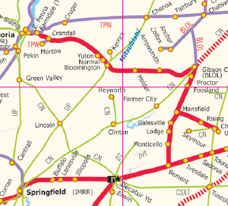
It looks like NS uses a former NKP track to get from Peoria to Bloomington. Then I assumed it uses a former  Big Four track to get to Mansfield. But when I looked at the Google Map to confirm the town names, I could not find any rail line for that segment! So I found another map from their site that is more detailed and accurate. It removes the guess work.

NS .pdf file

The train must have taken a former NKP route to Gibson City. Then it could use track-rights on the CN/IC to get back up to Kankakee where it can use the Kankaee Belt Route bypass. It is too bad the track for the Kankakee and Seneca was torn up, it would have provided a much less circuitous route between IAIS and NS.

Now that I have discovered that NS .pdf map, I can better analyze the northern leg of the Kankakee Belt Route. Below are excerpts from their system map and their Chicago inset.

NS .pdf file

NS .pdf file
 

A nice collection of historic and 2004 pictures for the Kankakee Belt Route.

Update:
Adam Elias posted the comment "BNSF 5450; NS 8101 (COG Heritage); On NS 31K clear of Chesterton at 11:33." The comments indicate that at Porter Junction the train leaves the NS Chicago line and takes the CSX Porter Branch (formerly the Michigan Central). Matthew Ginkel provided a link to a map showing current (2016) ownership and commented: "It takes the Green, to the Purple, to the Blue typically, or Green to orange to blue."

Thursday, October 2, 2014

Roundhouse Footprint in Columbus Ohio

Industrial Archeology evidence of steam locomotive servicing is one of my interests. When I arrived in the Chicago area in the 1970s, I made a point of studying quad maps to find roundhouses and then go photograph them. Posting those pictures is one of the reasons I started this blog. But doing field trips has priority because I need the exercise. To my surprise, one can still find remnants of roundhouses and coaling towers. 

I saw a Facebook posting that is worth noting. It has pictures of extensions welded to a turntable to handle bigger locomotives. And it explained where to find the footprint of the roundhouse that is in the pictures. I have also learned that road salt would be another product that is shipped in a block of covered gondola cars.

Update: this was part of Pennsy's 20th Street Shops.
Satellite


I-64 Wabash River Bridge

Bridge Hunters has several good views of this bridge. I got a grab shot while crossing the bridge that indicates the depth of the girders and the flare over the piers. (Actually, I was trying to get a picture of the RR bridge, but later I was impressed by the size of the girders.)

20140916 0037road

It was bad news to learn that the old steel truss bridges to the North and South of this bridge are no longer usable, but I was shocked to learn that this modern interstate bridge needs to be replaced. A 1985 flood caused an oxbow to be cutoff just north of this bridge and that cutoff increased the flow of the current on the Illinois side. That new flow is scouring the Illinois bank and destroying the I-64 bridge. Illinois has already paid $2.51 million for an emergency scour mitigation project on the piers. Illinois and Indiana are now working on an estimated $71 million project to replace the bridge. (CourierPress) Evidently Illinois tried to keep it a secret that the bridge was in trouble. (Navigator)

A link posted in May 2023 of a 2013 article: https://www.sj-r.com/story/news/2013/07/01/i-64-bridges-over-wabash/44193688007/. According to some comments, it still hasn't been replaced.

Jun 5, 2025:
Illinois Department of Transportation posted three photos with the comment: "Exciting news, White County! Demolition of the westbound I-64 Wabash River bridge near Grayville is in full swing. The deck and steel beams are gone, and Stage 2 is moving forward. Completion is expected by fall 2028. Project details: https://idot.click/8tm"
The $136m project is to begin Aug 19, 2025, and it is expected to be completed in fall 2029.
1

2
[Note the Aban/IC/PD&E Bridge in the right background.]

3

Oct 2026:
Was this video posted many moons ago and is just now being posted? I presume this is construction of this bridge.
Facebook Reel

Oct 16, 2026:
Illinois Department of Transportation posted
Exciting progress on the new I-64 Wabash River bridge in White County! The bridge is taking shape, with supports and steel in place and deck work underway. Thank you for your patience as we work toward a safer, stronger bridge—scheduled to open in November 2029.
Christopher Wood: Wasn’t this supposed to be done in 2027 what happened to that?
Max Bockelman: And I thought INDOT took forever on things🤣🤣 we built two whole on and off ramps for the new I-69 bridge in a year and a half.


New Harmony Wabash River Bridge

(Bridge Hunter; Satellite)

Street View, 2008
When I crossed the bridge a couple of years ago, I waited until I was ready to go home rather than do an over and back when I first visited the bridge because it charged a toll. I was glad because on the Illinois side you are on a raised road that has no shoulders for miles. And it looked like there was no where to turn around on the connecting roads. So I would have had to drive a long way before I could turn around if I had done an over and back. They must have closed the bridge soon after I did that crossing because it was closed May 21, 2012, when the toll company declared bankruptcy. Evidently the tolls went into someones pocket instead of into maintenance. I notice that Google and Bing Maps have removed the line across the river from their road maps. But Bing still has the line on their Birds Eye View.

If you look at the list of bridges in Posey County, there is already a remarkable number of truss bridges that have been replaced. Many of them in the 1990s. Even one that was rehabilitated in 1990 is now gone. I wonder if the same contractor did most of the new bridges. If so, is he a friend of the bridge inspector or a county board member? Or was there money available during the dot.com boom and the county wisely used it to fix their infrastructure? The reason local governments replace rather than repair bridges is that it is cheaper for them because the Federal Government will pay 90% for a new bridge and 0% for repairs. By "cheaper for them", I mean the local government. It is more expensive for the taxpayer because we pay federal as well as local taxes.


Vicki Sigrist Gilbert posted a photo.
Michael Brant Brittany Marie Thies that bridge is not there no more came down last year it’s on you tube
Dennis DeBruler Michael Brant Would you provide a URL? All I can find is 2018 news casts that are talking about reopening it.

Oct 2025. Evidently it is still closed.
Marsha Michael posted
The New Harmony Toll Bridge. It was permanently closed in 2012.


Wednesday, October 1, 2014

Former Aban/IC/PD&E Bridge over Wabash River near Grayville, IL

Update:  PD&E = Peoria, Decatur & Evansville
The first picture of thepde.info page of pictures is well worth a look. Note from the trees in the background how high the river is.

"Former" in the title has a dual meaning. First of all, this line was abandoned by the IC a long time ago. And as of December 27, 2011, the line has been completely abandoned. Secondly, the IC Grayville RR Bridge is no longer intact. I had noticed during the Fall of 2013 while crossing the I-64 bridge over the Wabash River that the second span from the west  (Illinois) side had the west end in the water and the east end still on its pier. It turns out the span fell when a pier failed during the 2005 flood. But the first time I was in the area after buying my "industrial history" camera, the broken span had finally been cleaned up. So it set broken for almost a decade, but between May and July of 2014 it was removed.

But when I studied the Bridge Hunter photos, none of them show a span that is half in the water and half on a pier, including a picture during the 2005 flood.

BridgeHunters: Norm Bredenkamp in Jan 2005.
Note that there seems to be the top of a washed out span visible under the railing of the I-64 bridge. The following photo confirms that the two fixed spans and the swing span you see above in 2005 still are intact, so now I'm really confused as to what span structure I was seeing in the river last Fall. I remember the end that was resting on a pier would have been on the leftmost pier in this photo.

20140916 0037rail
A Bridge Hunter photo shows that land is now under the swing span. This is because the flow in the river changed when an oxbow was cutoff by a 1985 flood. That increased flow on the west side probably helped destroy the bridge in 2005.

Photo provided by Thomas French

The original 2005 damage appears to be the loss of a pier and 2 fixed spans. The Bridge Hunter pictures show that another pier has failed.

BridgeHunters: Tom Barrows
BridgeHunters: Unknown

A 1910 postmarked postcard from the Bridge Hunter collection shows an older swing span and a ferry. Tony Dillon commented:
This is the original 1886 bridge that was built by the Keystone Bridge Company of Pittsburgh, PA. They also built the White River Bridge in Indianapolis that same year, and it still survives today. This bridge would be rebuilt in 1910 and the center swing span replaced again in 1965. The trusses of this bridge are extremely unusual and may possibly be of the Thatcher patent, which I have never heard of being used on a RR bridge before.
 Update Nov, 2014:
20141108 0268c
Robert Shelby posted
1971- pile driver on the wabash river bridge. Grayville IL

Tim Shanahan posted
Railroad crews at work on an approach trestle to the Illinois Central Bridge across the Wabash River near Grayville, IL.  During 1971 the IC rebuilt 9,500 lineal feet of timber and steel bridges.  This photo is now part of the Dillon Collection at the Illinois Railway Museum’s Strahorn Library.

Most of the trestle is tree covered, but some of it does show in a bridge picture.
I commented on a share. Unfortunately, Facebook has broken how I used to get a link to a share.
Dennis DeBruler I fired up Google Earth. It looks like the change was relatively recent. The channel below the swing span still has water.

Eddie Shine posted four photos with the comment:
Former ICRR bridge at Grayville IL.
This bridge was going to be part of a rail trail until the middle spans were washed out by a flood in 2005
1

2

3

Dennis DeBruler commented on the third photo
I see the sandbar has now grown past the first fixed span. It was not that far in my 2014 photo. Note that the sandbar under the east half of the swing span is so old that trees are growing on it.

4

Tim Shanahan shared a Snakegot Rattled post of four photos with the comment:
Indiana Hyrail operated on a shoestring. That thread broke when a pier washed out on their most profitable line, taking down two spans of the former ICG bridge over the Wabash River near Grayville, Illinois. The tracks were pulled up soon after. The article I referenced said this happened in 1990, but I remember walking over this entire bridge, something I could not have done before 1996.
Max and I revisited the site today. The approach trestle is thoroughly overgrown with vines and small trees growing out of the ballast.
1

2

3


4

This bridge has had a rather tortured history.
Bridges Now and Then posted
Not sure of the story on this photo. It's at New Harmony, Indiana in 1920. The University of Southern Indiana says "Railroad bridge across the Wabash River under construction. It's not entirely clear what is going on here, most likely an accident--there are train cars on the upraised, open part of the bridge, seemingly off the tracks." Looks like a swing bridge to me. Any ideas? 
The Southern Illinois Railroad site says "Illinois Central Railroad Bridge Collapses at Grayville, February 1918."
Richard Colby shared
Follow these two Flickr links for more information:   the above photo,   another photo.
[The derrick has been built to recover the the equipment. The description of the second photo says the Wabash used to have dams to aid riverboat navigation.]

David Cantrell posted two photos with the comment: "Grayville, Illinois Wabash River Railroad Bridge was built around 1892 according to bridgehunter.com on the route between Peoria and Evansville. First photo taken at 65 mile an hour crossing the I-64 bridge. http://bridgehunter.com/bridge/il-white-ic-grayville-bridge."
Tim Howard: Here is a story on the emergency repairs to the I-64 bridges and subsequent replacement plans. Looks like IDOT has the project in their MYP 2025. I remember hearing about the flooding up here in Springfield. https://www.sj-r.com/story/news/2013/07/01/i-64-bridges-over-wabash/44193688007/
1, cropped

2

Back when the Wabash River was still close to the town.
Andy Zukowski posted
Flooding caused damage to the Illinois Central Railroad on March 31st, 1913, at Grayville, Illinois.

Matt Koenig posted three photos with the comment:
Former Illinois Central bridge over the Wabash River as seem from I-64 on the Illinois/Indiana border.
It was abandoned in 1996 and a major flood took out a portion in 2005
Tim Shanahan shared
1
Dick Bradley: If you look at the right you can see the original swing section of the bridge. This was used when the old steam River boats traveled the river. It's now over dry land because the river shifted to the west after several floods and that's what undermined a couple of bridge supports.

2

3