Saturday, July 8, 2023

1900 Goteik (Gohteik) Viaduct in Myanmar (Burma)

(Satellite)

safe_image for Monster Trestle Bridge In The Jungle
It is 2,260' (689m, 0.43 miles) long and 335' (102m) high.

It was the highest railroad bridge in the world when completed in 1900. [BordersOfAdventure]
It was the second highest bridge in the world. "The trestle was designed in London. Pennsylvania Steel Company from Steelton USA was then awarded the contract in April 1899 to construct the trestle. Three steamers laden with steel components were shipped overseas from New York in August, October, and November of the same year. The construction project was overseen by Sir Arthur Rendel, engineer for the Burma Railway Company." [MyanmarTravel] I wonder which road bridge built before 1900 was higher.

Lat Aung App Pon Tone, Jun 2022, cropped

HighestBridges, Image by Martin Callum
It has 14 towers and one double tower.
"Although larger concrete viaducts and steel cantilever bridges were constructed before and after Gokteik, no other conventional box tower and girder type steel trestle has ever exceeded it in size except for the monstrous Lethbridge Viaduct in Alberta, Canada which is about the same in height but more than twice the length. The Joso bridge in the U.S. state of Washington, the Poughkeepsie bridge in the U.S. state of New York and the original Kinzua viaduct in the U.S. state of Pennsylvania are the only other traditional steel trestles that are equal in size to Gokteik."
[This "box tower and girder type steel trestle" is globally more rare than I realized. It must be a primarily North American design.]

This bridge was constructed in less than a couple of years. But the railroad between Burma and Yunnan was not finished in a timely fashion. [mdpi]

I Love Trains posted
[Same link as in the photo at the top of these notes.]

Khin Yu commented on the above post

Khin Yu commented on the above post


Thursday, July 6, 2023

1952 Mt. Morris Dam on Genesee River in Letchworth State Park

(Satellite, 426 photos)

I thought this dam would be close to the former-Erie Portage Bridge, but it is not that close because I now see that the Letchworth State Park is long.

I was surprised when I looked at the satellite image and saw more water on the downstream side than on the upstream side. This dam does just flood control.
USACE, Buffalo District, Photo by: Mount Morris Dam Volunteer Bob Oswald

Marilyn Coté Miller posted
Yesterday, (7/3/23) did a tour inside the Mt Morris Dam on the Genesee River at Letchworth St Park. The tour costs $1. You go down 150’ into the tunnels inside the dam. Very interesting.

The reservoir can hold 301,853 acre-feet. "When river flows exceed the natural capacity of the downstream channel and flood damage is likely to occur, flood waters are stored in the dam’s reservoir. As soon as downstream conditions permit, the stored water is released gradually through the nine conduits at the base of the spillway sections. About 30 days are required to empty a full reservoir at a rate that would safely avoid damage to downstream properties....During Tropical Storm Agnes in 1972, $210 million in damages alone were prevented, primarily in the Rochester Metropolitan Area. At that time, the inflows exceeded the storage capacity of the reservoir and it was necessary to release water through the gates of the dam, causing minor downstream flooding. These releases were made to prevent overtopping of the spillway. Had the spillway overtopped, accumulated debris in the reservoir would have passed downstream, causing log jams and additional damages. An inflow of the magnitude of Tropical Storm Agnes is expected to occur on an average of every 300 years." [USACE_history] I wonder how close the impounded water gets to the railroad bridge that is upstream from here.

It must not impound water very often because I could not find any photos with water stored behind the dam.
USACE, Buffalo District, Photo by Avery Schneider

John Kucko Digital posted three photos with the comment: "Mount Morris Dam:  The ultimate flood protection along the Genesee River is this right here—the Mount Morris Dam.  Opened in 1952, it’s estimated the dam has saved over $1 billion in potential flood damage throughout the Genesee Valley through the years.  Made a quick stop there today, lots of ice chunks and tree debris as expected.  Also, the last shot is of one of Letchworth State Park’s tallest cascades that often runs dry."
1

2

3

Lorrie Harris commented on John's post
This picture was taken in 1972. At least that what I wrote on the back. We had a hurricane tear through New York and this was the result.
Thomas Sandford: Lorrie Harris hurricane Agnes
 
Jeff Church commented on John's post
Was Dry in august, Has the water ever gone over the top of it??? If so that would be crazy.
Karen Gibson: In 1972 water was only feet from the top of the dam. Openings at the bottom (9) were opened all the way to stop overflowing. Damage to the dam basin on the north side would have been great from the debris over the top. Flow was regulated until danger was past. Flooding downstream was kept to a minimum. The damn was completed only 20 yrs. earlier and paid for itself in 1972.
Andy Fraser: Karen Gibson I remember going to see the Dam then and all the talk was if it was would hold. It had never been tested like that before. I believe it was two feet from over flowing.

Connie Ash Tartick commented on John's post
John I found this photo among my parents photos. Thought you might enjoy this photo of the progress of the building of the dam.

2 of 9 photos posted by USACE, buffalo District with the comment:
The Mount Morris Dam is critical to protecting people in the Genesee Valley and City of Rochester. And inspections are critical to the dam's operations and maintenance.
🧰 On top of daily and annual inspections by the dam's staff, we bring in a team of engineers from multiple backgrounds to conduct an in-depth periodic inspection every five years.
💵 For 73 years, the dam has served the region, and prevented an estimated $4.5 billion in flood damage. That's huge value compared to the $24M it cost to build in 1948.
📰 Check out news from this year's inspection from...
∙ News 8 WROC Rochester -- https://www.rochesterfirst.com/.../holding-back-the.../
∙ Democrat and Chronicle -- https://www.democratandchronicle.com/.../mou.../83643727007/ 
[Please access the posted link to access the news links.]
a

b

Wednesday, July 5, 2023

2015 Nhật Tân Bridge over Red River in Hanoi, Vietnam

(Satellite)

Unlike many of the bridges I have seen in China, this one has some traffic.
Highway Engineering Discoveries posted, cropped
Hanoi‌, Veitnam [sic]

ne-con
Vietnam - Japan Friendship Bridge
"The Nhật Tân Bridge is the largest bridge in Southeast Asia, with a total extension (including installation bridge section) of 3,755 m. Considering the interannual variability of the Red River riverbed, which the main bridge spans, a double I-girder cable-stayed bridge with six continous  spans was selected, with a bridge length of 1,500 m (center span length 300 m)."
It connects Hanoi's city center with Noi Bai International Airport.

ScienceDirectAssets, p2 and ScienceDirect

They used jump-form construction to build the pylons.
ScienceDirectAssets, p6

HanoiTimes
"These five towers represent Hanoi’s five ancient gates in the old time."

Tuesday, July 4, 2023

1959 1.05gw+1.08gw Kariba Dam on Zambezi River at Zimbabwe+Zambia

(Satellite, 1,809 photos)

RhodesianStudyCircle
"The Kariba Dam is a double curvature concrete arch dam in the Kariba Gorge of the Zambezi river basin between Zambia and Zimbabwe. The dam stands 128 metres (420 ft) tall and 579 metres (1,900 ft) long. The dam forms Lake Kariba, which extends for 280 kilometres (170 mi) and holds 185 cubic kilometres (150,000,000 acre⋅ft) of water."

nsenergybusiness, also e360.yale.edu
Kariba Dam is the largest in terms of water storage capacity. Kariba South has a capacity of 1.05gw and belongs to Zimbabwe while Kariba North has a capacity of 1.08gw and belongs to Zambia. "Although the Kariba South power station typically accounts for more than half of the country’s electricity, low dam water levels due to the prolonged drought in the region since May 2019 has led to trimming down the facility’s electricity output to almost one-fourth of its design capacity as of December 2019." Both of these countries were part of Rhodesia, which was created by Britain. "The Kariba Dam has been undergoing a £235m ($294m) rehabilitation project since 2017, in order to fix the deformities on the structure that were figured out in a series of assessments. The Kariba Dam overhaul project involves the reshaping of the plunge pool and the refurbishment of the spillway gates."

FLY HAC posted
At HAC, you always get the bird's eye view, including a sneak peak of the Kariba Dam wall rehabilitation program.
Zambia - The Real Africa posted

The access road to the bottom of the plunge pool is nearing completion.
FLY HAC posted
The views at HAC continue! With an update aerial of the Kariba Dam wall rehabilitation program from a recent fly by.

I zoomed out to see where we are in Africa, and you can clearly see Lake Kariba.
Road Map

RhodesianStudyCircle
"The double curvature concrete arch dam was designed by Coyne et Bellier and constructed between 1955 and 1959 by Impresit of Italy at a cost of $135,000,000 for the first stage with only the Kariba South power cavern. Final construction and the addition of the Kariba North Power cavern by Mitchell Construction was not completed until 1977 due to largely political problems for a total cost of $480,000,000. During construction, 86 men lost their lives."

All six of the floodgates are open.
ZimFieldGuide
"On the rare occasions that all six flood gates have been opened, over 9,500 cubic metres (300,000 cubic feet) of water surges into the river below each second!"
[To put that in perspective, the design capacity of the Oroville Dam is 160,000 cfs.]

Two of the flood gates are open.
ZimFieldGuide
The commercial fishing of kapenta, the size of sardines, in the lake has been decimated by the red claw crayfish. "Even crocodiles don't eat crayfish." The crayfish are a threat to other species as well.

Feb 24, 2023      
voanews
"Zambians and Zimbabweans have been suffering long hours of power loss since water levels at the Kariba hydropower dam plunged to an all-time low in December. Columbus Mavhunga reports from Zambia, which plans to build a $2 billion solar power project to alleviate the situation."

There is a paywall, but I was able to read that the lake is down to less than 1% of its usable water in Dec 2022. [Bloomberg]
The dam has not been at full capacity since 2011. [EnergyPolicy]
"Building the dam and its reservoir forced the resettlement of around 57,000 Tongan people living along the Zambezi in both Northern Rhodesia and Southern Rhodesia." [ice]
"When the floodgates were opened in 2010, 6,000 people had to be evacuated....Its plunge pool is now a 266-foot-deep crater. As the stony facade continues to crumble, the likelihood rises that the Kariba Dam will not just fail but fall. If the dam collapses, the BBC reported in 2014, a tsunami would tear through the Zambezi River Valley, a torrent so powerful that it would knock down another dam a hundred miles away, the Cahora Bassa in Mozambique — twin disasters that would take out 40 percent of the hydroelectric capacity in all of southern Africa." [nytimes]
The nytimes talked about the impact on hydroelectricity, but not on people's lives. Is it such a wilderness that there are no people in the river valley?
No, there are 3.5 million people. [e360.yale.edu]

2009: The dam "has been a cause for concern on a number of safety issues, including from its earliest days when the filling of its reservoir caused earthquakes, to more recent times when rumors began to surface that the huge dam had structural problems and suffered from poor maintenance. Kariba has also worsened the region's floods in recent years." After bad floods in Mar 2000, the US Army Corps of Engineers (USACE) was requested to inspect the river's dam. They were given full access to Cahora Bassa and Kafue dams, but not Kariba.  "Kariba, like many dams, has been affected by a condition that mars its concrete, known as “alkali-aggregate reaction.” " But the dam operators are keeping the amount of degradation a secret! [InternationalRivers_1]

2012: The plunge pool is deeper than expected. It is not the eroded depth of 90m (300'), but the proximity of the hole to the foundation of the dam. In fact, the preferred solution is to widen the hole.
InternationalRivers_2, Source ZRA ppt, 2012
Multi-beam bathymetric photo of the Kariba Dam plunge pool.


This diagram provides the cross-section I need to illustrate why this is a double-curved arch dam. A normal arch dam looks curved when you view it from above. A double-curved dam also looks curved when you view it from the side.
InternationalRivers_2

2018: The budget to repair the dam is US$294m. "According to the Zambezi River Authority’s KDRP Project Manager, Eng. Sitembinkhosi Mhlanga,  the existing pool will be widened from bank to bank and will also be extended in the downstream direction. The result will be an enlarged pool with an increased volume. The enlarged shape will create a water cushion which will improve the capacity of the pool to absorb the potential energy from spillage, thus reducing the development of the pool, and ensuring the stability of the dam foundation....Over time, alkali aggregate reaction can occur in concrete exposed to water causing the concrete to swell. This causes distortions to the steel-lined guides of spillway flood-gates, affecting the spillway functionality....The spillway refurbishment is part of this dam safety assurance process." They are studying two more dam sites on the river. [zambezira] They make a big deal about having a lot of instrumentation to monitor the performance of the dam. But they don't mention if they are still keeping the data a secret. 

Monday, July 3, 2023

Milwaukee Eagle Nest Tunnel and Trestle over 16-mile Creek near Francis, MT

(Satellite)

"In the winter of 1980 The Chicago Milwaukee St Paul and Pacific Railroad (Milwaukee Road) abandoned almost two thousand miles of track west of Miles City Montana. The abandonment of the “Pacific Extension” was the largest single railroad abandonment in American history." [1980 Flickr]

Jim Arvites posted
On this Day in History on June 19, 1947
the Milwaukee Road flagship train "Olympian Hiawatha" made its first runs between Chicago and Seattle/Tacoma on a 43 Hour 30 Minute schedule. Picture below of the "Olympian Hiawatha" at Eagle Nest Tunnel in western Montana in 1954.
(Sandy Goodrick Photo)
Glenn Olsen: That would have been the fastest schedule between those cities, beating the Empire Builder's 45 hours.
[A "Little Joe" electric locomotive.]
Lance Erickson: Area privately owned today.
Also American-Rails
"It is somewhat ironic then that 'Lines West' was actually one [of] the railroad's few profitable components when it entered bankruptcy for a final time in 1977."
[But Milwaukee management cooked the books to make it look unprofitable so that they had an excuse to abandon it. The Milwaukee is an example of how bad management can kill a railroad.]

The tunnel is not very long, but the east portal is just a rock cut (i.e. no concrete lining), and it opens out directly onto a trestle.

mtmemory, Montana Historical Society Research Center, Educational Use Permitted
"View of Chicago, Milwaukee, and St. Paul Railway Company train crossing railroad trestle preparing to enter Eagle's Nest Tunnel with Sixteen Mile Creek alongside and mountains and trees in background; passengers and conductor in last railroad car. Note on back: 'The Milwaukee famed 'Olympian' powered by a Baldwin-Westinghouse electric locomotive, is shown at Eagle Nest Tunnel in Montana Canyon (near Ringling) in 1939. The complete absence of smoke and cinders on the railroads electrified districts made it possible for passengers to enjoy the luxury of riding in open observation cars through the grandeur of mountain scenery along the route.'"

Note the blue arrow on this map. It points to the Eagle Nest.
American-Rail

1979 Flickr, the Milwaukee had switched to using diesels.


Sunday, July 2, 2023

1960 I-70 Rocheport Bridge over Missouri River near Columbia, MO

(Bridge Hunter broke Mar 22, 2023; Satellite)

Missouri's Historic Highways posted
06-26-1961 I-70 Rocheport Bridge
Marvin McKelvy: No traffic back then. Now there would be 100 cars in that photo.
Russ Gilmore: River had a lot more water flowing through it back then.
[Comments indicate that since the 1993 flood, the farms have been turned into wetlands.]

Street View, Apr 2023
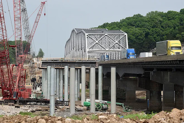
Yet another truss bridge that is being replaced by a UCEB (Ugly Concrete Eyesore bridge). Although there is no shoulder on this bridge.
 
kmmo
The current bridge was opened in 1960. The new bridge is expected to cost $240m. "The bridge carries 12.5 million vehicles per year, including 3.6 million trucks." The crossing will have two bridges, one for each direction of travel. And each bridge will carry four lanes of traffic.

It looks like the old bridge had some non-trivial steel girders in its approach spans.
Amy Lade, Aug 2017

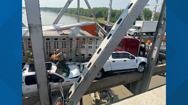
This Jun 6, 2023, accident closed the highway for about 6 hours.
ksdk, Boone County Fire Protection District      Also kbja
"Boone County fire said one person was removed from a vehicle involved in the crash and taken to the hospital. They did not provide an update on their condition. There were no other reported injuries."
The livestock trailer was hauling 55 cows. They sent a brush truck to cool down the cows while they untangled the accident. I think a brush truck is a fire truck with a small pump and a big water supply.

modot

ColumbiaTribune, Don Shrubshell/Columbia Daily Tribune
"The new crossing will be called the Lance Cpl. Leon Deraps Interstate 70 Missouri River Bridge. Deraps, a Jamestown native, was killed at the age of 19 while serving with the U.S. Marines during Operation Iraqi Freedom in 2006."
The first bridge was supposed to be completed in spring of 2023 rather than in June. Construction started in Oct 2021.
"An 11-foot [3.4m] diameter drill bit is being used to drill holes through 50 feet [15m] of riverbed and earth and 20 feet [6m] into bedrock to place the support structures."

ColumbiaTribune, Don Shrubshell/Columbia Daily Tribune

Saturday, July 1, 2023

1937,2010 Port Royal Bridge over Juniata River at Port Royal, PA

Truss: (Bridge Hunter broke Mar 22, 2023; Historic Bridges; Satellite)
Overpass: (Historic Bridges)

The truss bridge on the left caught my eye.
Worldwide Railfan Productions posted
Port Royal Bridge Demolition
A Norfolk Southern intermodal train with AC44C6M 4314 heads west under the demolition site of the PA Route 75 road bridge. This single span concrete bridge spanned four tracks upon its completion in 1910
Location: Port Royal, PA
 By: Brandon Fiume
 Taken on: April 20, 2023
http://www.brandonfiume.com/photos/details/375
Dennis DeBruler: I'm glad you caught all of the truss bridge. They are becoming more and more rare.

The truss bridge was repaired and repainted in 2010. [both HistoricBridges]

RootsWeb
The first bridge was built in 1831. The truss bridge is the fifth bridge at this crossing because of recurring floods. It opened in Dec 1937.

The previous (fourth) bridge was a covered bridge built in 1892. It aligned with a crossing of the railroad tracks at Milford Street. At the beginning of the 20th Century, since the automobile was becoming more prevalent, the Pennsylvania Railroad embarked on a program to replace grade crossings. Thus the railroad built the concrete overpass at Market Street and a ramp to connect it to the river side of Milford Street. They also built a new depot. (The depot was removed in 1969.) [PortRoyal200] The photo below not only shows the 1937 flood that took out the fourth bridge, it also shows the alignment of the road between 1910 and 1937. (The waters have receded some in this photo.) Obviously, when the truss bridge was built, they moved the location of the bridge so that it could attach directly to the overpass ramp.
10th of 36 photos on PortRoyal200

The Pennsy tracks were reduced to three in 1955, and to two in 1985. [Caption on 15th photo in PortRoyal200] (You can see at least seven locomotives pulling a westbound train in the 15th photo. The 16th photo shows eight locos, and the caption notes that is unusual.)

The ramp has already been rebuilt to make it wider and less steep. This show the 1910 ramp.
31st of 36 photos on PortRoyal200

It looks like a derrick used during construction has yet to be taken down. The wood crossing in the foreground was the Milford Street Crossing to the covered bridge. It has yet to be removed. Note that the steam locomotives have already deposited soot on the overpass.
2nd of 36 photos on PortRoyal200

Did they cover the rails with wood to protect them from the falling concrete?
0:12 video @ 0:09

The bridge was closed on Mar 27, 2023, to replace the 1910 overpass. [Caption for the 34th photo on PortRoyal200]
The replacement includes new water and sewer lines and costs $4m. [einnews]
The closure is expected to last six months. [PennLive]

Bonus


Juniata County still has three covered bridges.
UncoveringPA